

Frog Town
-
Posts
970 -
Joined
-
Last visited
Content Type
Profiles
Blogs
Forums
American Weather
Media Demo
Store
Gallery
Posts posted by Frog Town
-
-
Thanks for the insight. It just really makes you wander which way this is gonna go. I've fought the NW trend all my life, now i'm fighting the SE trend. Maybe it's time to move, lol.
-
So why is everyone's forecast hedging towards the GFS operational in their AFD's??
-
The GFS Para has a totally different look. Which one has been better lately??
-
So what's the consensus here?? Are most abandoning the Euro and going with the GFS? Can someone post an ensemble blend of the two for comparison? That would be much appreciated and might help.
-
TY
What's more interesting is it's axis of heavy snow. Any validity to that, or is it also a complete outlier.
by amped, you were probably also refereeing to it's position as well. got it
-
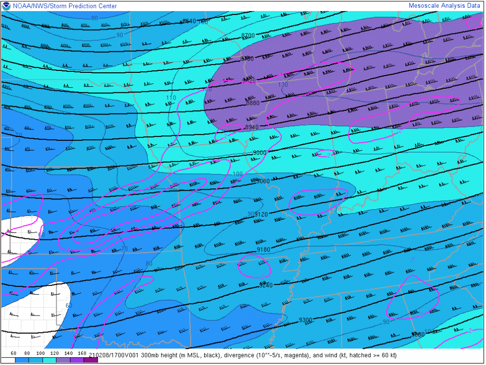
Can someone explain the 21z RAP and why it's so far northwest?? Is it a joke model that never verifies, I assume, based on the sarcasm.
-
12Z NAM trajectories are an improvement for those a bit west.
-
 1
1
-
-
Basically the Euro vs. the GFS more the mid forum folk......Normally I'd be be giddy for what the Euro is showing, but things have been strange lately.
-
1
-
-
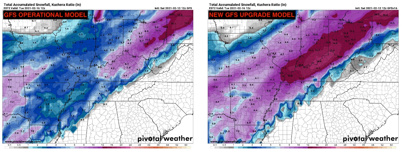
Can someone explain the difference between the two snow maps above?? I guess I always thought the Kuchera was I higher ratio version, but the difference above seems to be more than that.
-
Anyone mind posting the Euro snow map for this storm. Offices seem to be riding this more than what the GFS and others are showing. Thanks!
-
This is 3 storms combined. May be a bit misleading
-
1
-
-
Nice trend for those along I-80
-
54 minutes ago, StormfanaticInd said:
Next week *could* make up big time for this winter in central Indiana!
Is there an echo in here??
-
 2
2
-
-
This would be sooo much better if this weekends storm would materialize into something. I feel like we a chasing ghosts if nothing actually happens that is even close to the models.
-
2
-
-
Holding together here in NW OH and SE MI for some nice high ratio fluff. Still amazing the trend this winter for systems to fade as they reach this longitude....
-
1
-
-
3 hours ago, purduewx80 said:
this is where old-school meteorology gave us some clues for today. not too surprising that fgen forcing is more intense than modeled given this jet streak passing by (it gradually lifts NE from where it's shown below). shame it won't be in place longer than a few hours. That said, there is focus at 700mb through the night, so light snow may end up persisting all the way into tomorrow morning in the general areas its occurring now.
The radar is looking way more solid than the modeling. Purduewx80 was spot on in his analysis!
-
Is the real cold actually gonna come south of 80 like modeled and forecasted for days now?
-
light weight
-
1
-
-
I've noticed over the years that the Big Storms usually come at the beginning, or end, of an arctic air mass. The Euro is hinting at the end of this current outbreak. Week of 15-19 seems to be our best chance of something special.
-
1
-
-
43 minutes ago, MIstorm97 said:
I'd take that HRRR run all day. Low gets cranking as it over CLE and is a great hit for the SEMI crew. Feeling optimistic with this one. Felt good for the last storm too and it played out how I thought it would. Bring it
First call: 5"
Looking at pattern recognition, this appears more likely, and not just because it benefits me more, lol.
-
Why CLE wouldn't issue any advisory for the Toledo area is beyond me! We've had two inches in two hours and have accidents everywhere. We also have another 2 to go. On top of that we will have a legit flash freeze overnight with 30-40 mph winds and an absolutely treacherous morning commute. It's like having 7/10 indicators for tornadoes and not issuing a watch. Almost borderline negligent. If it's not happening in Cleveland proper or the snowbelt, they won't mention it.
-
1
-
-
29 minutes ago, Stebo said:
There is very obviously a SE ridge there too. It can only trend so far south.
It's nice to have Stebo in our neck of the woods offering his insight and wisdom. He's kind of like a big brother for us Michigan/Indiana/Ohio folk. Thanks, Stebo
-
5
-
-
10 minutes ago, CheeselandSkies said:
Thought it was for all types of weather.
Most of us take a hiatus from April-November
-
1
-
-
Definitely wagons south with this so far today. Seems to be a disconnect with Thermals though. Models seems to be playing catchup with a quickly evolving pattern. Thoughts??
February 14-16 Winter Storm
in Lakes/Ohio Valley
Posted
Sarcasm aside, do you see this coming back a little bit??