

Normandy Ho
-
Posts
3,295 -
Joined
-
Last visited
Content Type
Profiles
Blogs
Forums
American Weather
Media Demo
Store
Gallery
Everything posted by Normandy Ho
-
Even that example there is not nearly enough information to say an outrageous statement that there are “no connections”. The entire building is gone. The only thing I can even begin to deduce is it was a wood frame house, with wood framed floors, built on CMU walls with a Crawl space beneath. And even that assumption is guesswork with no other elements to review.
-
More nonsense. That is a standard wood stud framed single family home with brick veneer facing. It has standard anchorage to the slab as seen by the bolts sticking out of the base stud. The brick is completely non-structural and can actually be removed by winds lower than 100 mph. The wood framed building cannot be removed by winds that low, and that is fairly obvious. They have no clue what they are looking at if they think an EF-2 tornado did that.
-
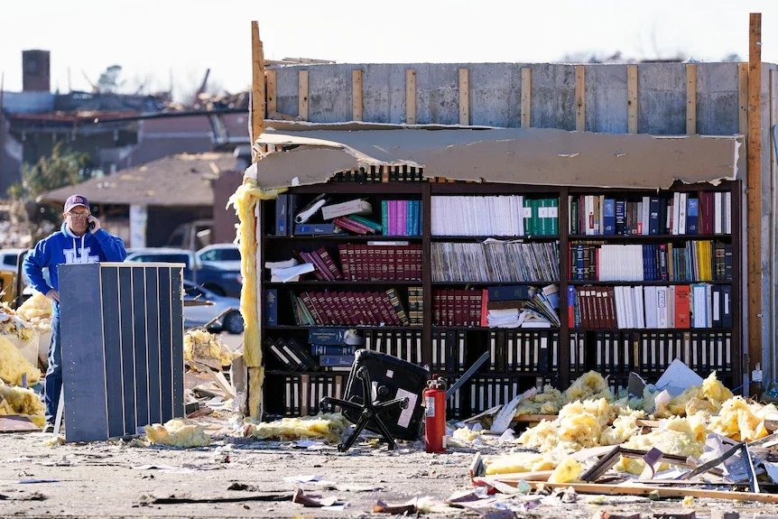
Even the fact that a preliminary analysis of this turns out an EF-4 designation is very problematic. There are several obvious indicators that this was as strong as other tornadoes that have been given both the EF-5 and F-5 designation. Stating that there is a lack of "well-built" structures that have been swept away with only slabs remaining as a justification of not finding EF-5 damage is absurd. As an architect this frustrates me because how is anybody defining what "well-built" means, and more importantly: How can you determine if something was well-built if the entire damn structure is gone? People can say "Well look at the anchorage". There is no building code that requires a structure have anchorage that can survive 200 mph winds. From an engineering standpoint is isn't feasible with wood frame buildings (never mind the fact that the 200 MPH winds are throwing cars, trucks, etc at high velocities that impact the structure). I cannot emphasize this enough: A building is only as "well-built" as the local building codes dictate. The definition of "well-built" should not be determined by the ability to partially survive a 200 MPH tornado. Building codes do change often times, and are usually caused by natural disasters. However I can pretty much guarantee that building codes in tornado alley do not have provisions like those in other natural disaster afflicted areas (hurricane zones, seismic zones, etc). And even if they have it is a moot point because the damage assessment requirements are extremely vague. The EF scale is so flawed on so many levels that its hard to even use it as a scientific tool. How can the El Reno tornado be an EF-3 when 300 mph winds were measured by DOW? How can the Jarrell tornado be an EF-5 based on damage alone when it was moving 10 mph (as opposed to other faster moving EF-5's like this one who did the same damage)? How are we simply ignoring other factors like defoliation, trees being debarked, ground scouring, etc? Damage should never be the be all, end all factor in determining tornadic windspeeds: because we have no earthly idea why tornadic windspeeds do the damage they do. And I present the picture below as evidence. Nobody who is assessing damage can sit in front of me and tell me with a straight face that this tornado did not have 200 mph winds because of poorly built structures when we have a damn bookshelf with books untouched while the entire rest of the house is completely gone. Its all completely absurd and incredibly unscientific.
-
Upon closer inspection of this photo, I do not see the rebar within the pieces of concrete (you would see them sticking out the edges). That being said there is ample evidence that this was EF-5
-
The combination of tree defoliation, mangled vehicles, high death toll, and multiple houses swept clean off foundation leads me to believe EF-5 is likely. Terrrible tragedy and prayers to those affected
-
The latest GFS now develops a second low north of the first one ahead of Sam. Leaves the first cut-off low behind and recurves Sam and the second together. Unsure how plausible this is, why would the second low develop? Would like to hear from a met
-
Sam is really going to work right now. Likely approaching major status
-
The CMC solution is definitely plausible, as all models have the same players on the field. The CMC is just further west and faster, thus allowing the ridge to become more of a blocking ridge and encouraging the phase. Is it the most likely? Probably not.
-
GFS maintains the idea of cutting off a low ahead of Sam, having that low be drawn SW while Sam pinwheels around it heading due north at landfall.
-
Appreciate the input. Lets see what the subsequent model cycles show
-
Can you explain this a little more? That's not how I am reading this and want to be schooled on how I am interpreting this. See tweet below for what I am seeing: https://twitter.com/andretrotter/status/1441137766515937280?ref_src=twsrc^tfw|twcamp^tweetembed|twterm^1441137766515937280|twgr^|twcon^s1_c10&ref_url=http%3A%2F%2Fstorm2k.org%2Fphpbb2%2FEmbedTweet.html1441137766515937280
-
Going to be very close if the Euro pans out. Cut-Off Low to the west with a ridge to the east implies a due north track after the run. Which of the two features becomes the dominant steering element likely dictates whether or not landfall occurs on the East Coast. Stronger low seems like it would send it more west, stronger ridge seems like it would send it slowly north before ejecting NE when the next trough comes in. On the next cycle!
-
The GFS seems to be creating to much spurious vorticity that is causing chaos with the track of Sam. I’m hedging my bets on the euro which has been much more consistent and reasonable
-
It seems like the delayed development is hurting us downstream as this doesn't find the first weakness north. Lets see what the next GFS shows but the Euro showing this consistency is a bit alarming.
-
Hate to gravedig but like I said in the 2021 Atlantic tropical thread this video is required viewing https://youtu.be/Ar8Usv-Kwvs
-
2021 Atlantic Hurricane season
Normandy Ho replied to StormchaserChuck!'s topic in Tropical Headquarters
I could not locate the Dorian thread so I posted it here…. But Oh my ****ing god at this video from marsh harbor. Video is required viewing https://youtu.be/Ar8Usv-Kwvs -
Instantaneous gust or not that still a ridiculous observation. And what exactly is the definition of instantaneous (1-second long?)? I don't know why but since you claimed you saw stronger winds than Josh did in Dorian I always view your posts as angling to keep Michael greater than "x".
-
If this shouldn't be named then what should be named? Does it need to have an eye or something? This complaining about naming of systems is getting ridiculous
-
From what I remember Grand Isle did get into the eyewall....Port Fourchoun was in the middle of the eye and Grand Isle is a few miles east of that location. Its fairly likely Grande Isle received the worst winds in Ida
-
2021 Atlantic Hurricane season
Normandy Ho replied to StormchaserChuck!'s topic in Tropical Headquarters
Unless we have multiple C4 / C5 hurricane strikes on US soil....season ain't exciting enough. -
The most certainly will get upgraded during the next NHC pakcage
-
This thing is crawling to the coast at this point. Gonna need to make some progress inland since models are forecasting a stall and turn east
-
Watching closely for any convective burst occurring on the western flank of the circulation. Radar suggests that the storm while deepening is still limited with respect to western Inflow
-
This would be nothing new to Houston. These 1 and 100 year floods are no longer 1 and 100 year anymore. This region of the country is used to flood events like this. I’m more concerned about this over performing from a wind standpoint. It’s generating a lot of vigorous convection which is usually a sign that over performing in intensity is a possibility
-
2021 Atlantic Hurricane season
Normandy Ho replied to StormchaserChuck!'s topic in Tropical Headquarters
If your measurement of active is cat five hurricanes making landfall then sure I guess you are right. Problem is that’s not how active seasons or active periods are measured.


