

MUWX
-
Posts
1,173 -
Joined
-
Last visited
Content Type
Profiles
Blogs
Forums
American Weather
Media Demo
Store
Gallery
Posts posted by MUWX
-
-
6 minutes ago, The Waterboy said:
Meaning the current actual temp is 2-3 colder than what the HRRR shows?
Yes, at least in the Mt. Vernon Missouri area. The current temp (11:30) at the university of Missouri extension office in Mt. Vernon is 36.3 and the 16z HRRR showed it being roughly 38 there at 11.
-
The 16Z HRRR is 2-3 degrees too warm at 11:00. That's not insignificant
-
6 minutes ago, MoWeatherguy said:
I found one model that still looks bullish this morning. Go RAP!

Most of the models still seem bullish to me. Especially for northwest Arkansas
-
May be of significance or it may not, but we got down to 24.4 last night. Forecast low was 28
-
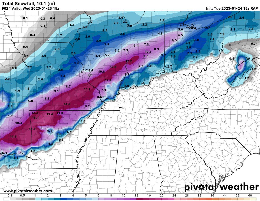
Some of the QPF totals being put out by models are insane tonight. If SGF is right, and ratios are close to 12-1…. Could get pretty crazy.
Oklahoma is getting screwed because most of theirs will fall during the daylight hours, and with marginal temps, I don’t think they see efficient accumulation.
-
2 hours ago, stormdragonwx said:
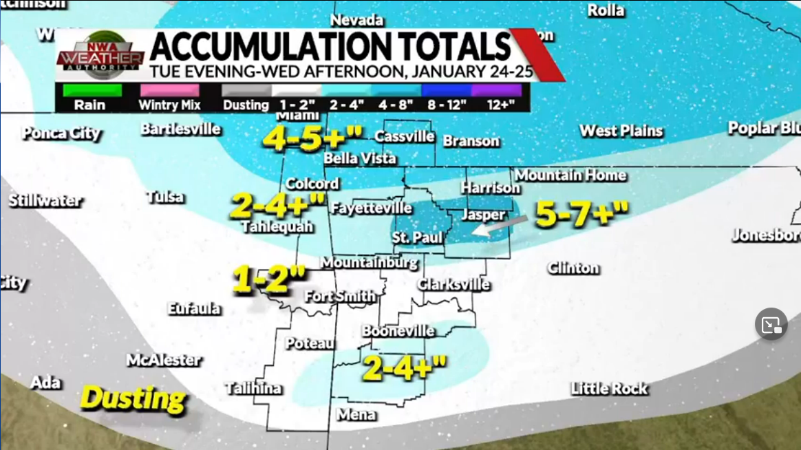
Local forecast totals from KY3 in Springfield and KNWA in Fayetteville. Naturally the guys here in Arkansas are playing it more conservative. Its not too often we see 8+ here.
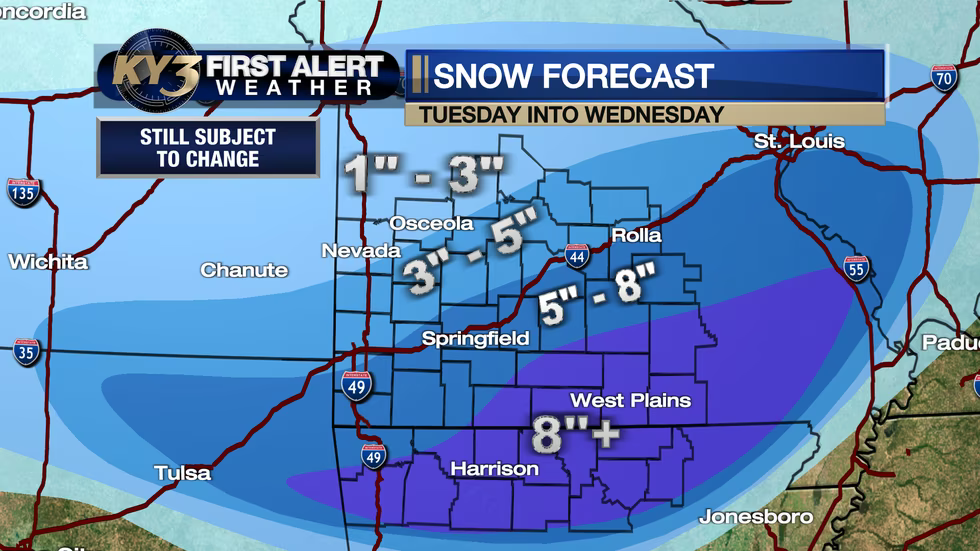
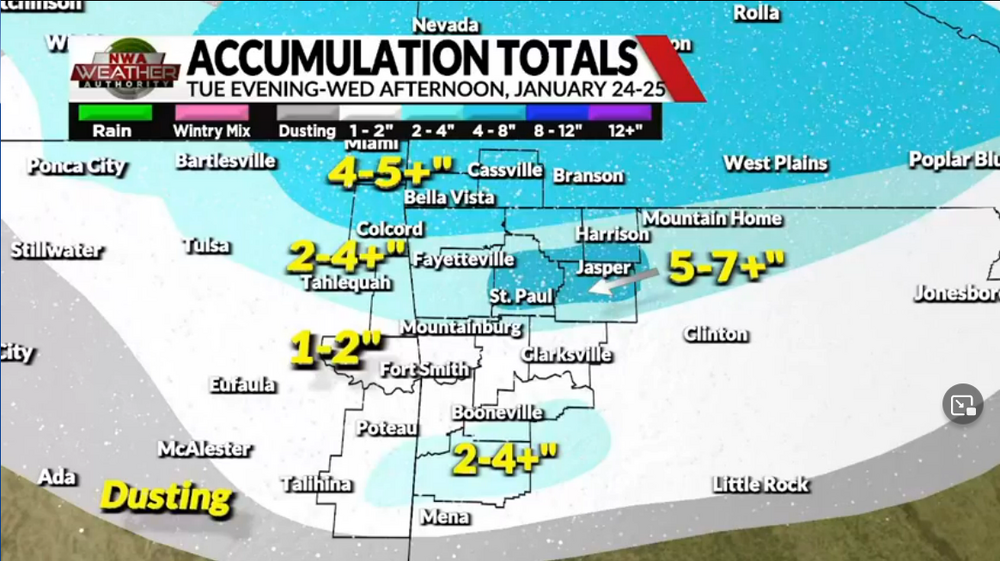
For what it’s worth, KY3 already lowered amounts slightly
-
8 minutes ago, JoMo said:
00z NAM shifted a bit back north.
Maybe a touch colder than 12z, definitely colder than 18z.
-
 1
1
-
-
If we can get another nudge to the north, SWMO might be a really solid spot since most of the snow will fall at night. Even with marginal temps, I think the snow could pile up with no sun
-
Southern trend continues on the GFS
-
Pretty interesting stats
-
1
-
-
-
Surprised there isn’t more talk about next week. Latest Gfs and Canadian are very similar at this range.
-
-
Starting to see some very faint returns on radar. I think we’re gonna have a decent period of freezing drizzle before the snow starts.
-
57 minutes ago, rockchalk83 said:
I thought Kuchera only took into account the column temp below 500 mb? I don't think wind factors into any of the SLR equations at all.
Still, though, I see where you're going. The wind is going to shred the dendrites and make them smaller, thus, harder to accumulate.-
1
-
-
I’d still heavily caution against getting your hopes but based on kuchera. The strong winds will be working hard against high ratios. Kuchera doesn’t factor that in
-
1
-
-
Springfield extended their winter storm watch. It now includes basically everyone except the southern tier of counties.
-
The icon continues to be much faster with the cold air. The 0z icon is about 3 hours faster with the cold air than the nam is. This results in a 6 am temperature difference of 21 degrees between the two models.
-
1
-
-
21 minutes ago, The Waterboy said:
For what it’s worth (which may not be much) the ICON has continued to trend more in our favor over the last 5 runs. The 18z was actually pretty solid.
The icon moves the cold air in fast. I think that’s what needs to be watched the closest
-
SGF went with a watch for their northernmost counties but only mention 2-4 inches for them. Seems pretty reasonable to me. I think most of us struggle to get to 2”.
-
1
-
-
36 minutes ago, StormChazer said:

I'm not asking for 10 inches here in North Tulsa, I'd be happy with 3-4(heck 2 at the rate it's going).
Just need a 30 mile shift south. I don't feel like that's egregious to ask for at this stage of the game, still possible...
I know ratios are likely to be above 10-1, but i wouldn’t rely on the kuchera numbers either. They are notoriously overdone historically.
-
6 minutes ago, StormChazer said:
What’s odd is to my unprofessional eye, the gfs diggs south and west a touch more and yet the precip shifted considerably north. Want to see the ensembles and see if this winds up being an outlier.
The low tracks way north. A low going from Nevada, mo to southern Illinois isn’t gonna produce much for most of us here.
-
7 minutes ago, JoMo said:
lol. Still a lot of runs left. Congrats Minneapolis?
Seems unlikely to me that we trend south over the next 4 days but we shall see. Most of us have been on the southern edge for a while now and that rarely turns out favorably 4-5 days out.
-
It was fun while it lasted
MO/KS/AR/OK 2022-2023 Winter Discussion
in Central/Western States
Posted
Yeah, its looking that way but still a long way to go, and it could mean that we just never really cool off this evening.
With that said, the HRRR is still 3-4 degrees too warm at soon .