

MUWX
-
Posts
1,173 -
Joined
-
Last visited
Content Type
Profiles
Blogs
Forums
American Weather
Media Demo
Store
Gallery
Posts posted by MUWX
-
-
The first round is winding down here in Monett. Tried to change to change over to sleet at the end but it never could fully get it done. Our deck is starting to ice over with the rails solid ice. Now that the rain has ended, I ventured out to the yard, and was fairly surprised. The trees are pretty weighted down, a lot more ice accumulated than I thought. Nothing major, but the cedar trees are touching the ground. If this last band puts down some heavy wet snow, the trees are really going to be weighed down.
-
Starting to give up hope that this is ever going to transition in Monett. Moderate "freezing" rain has been occurring for hours, but only a few slick spots on elevated surfaces.
-
NWS is buying the HRRR and holding the snow off until way after midnight. Sounds about right, never easy to get snow here.
-
Sgf pulled the trigger on a WWA and went with ~3 inches along the I44 corridor. Seems like a good bet to me, most models seem to be locking in on that solution. We still need to watch temps and see if they fall faster than anticipated. Monett has been locked in at 34 for quite some time now. Airport dropped to 32 earlier, but I'm not sure they was accurate
-
4 minutes ago, NwWhiteOut said:
Down to 39 here now, slowwwwwly falling. Kinda misty outside
34 in Monett, seems models might be a little too warm but I'm not positive.
-
3 minutes ago, StormChazer said:
Can you link me to this? I'm having trouble finding it on their page.
I'm interested to see if they are saying 1-2 because they don't want to say double that just yet, or if they don't believe this because it's based off something they don't trust with certainty.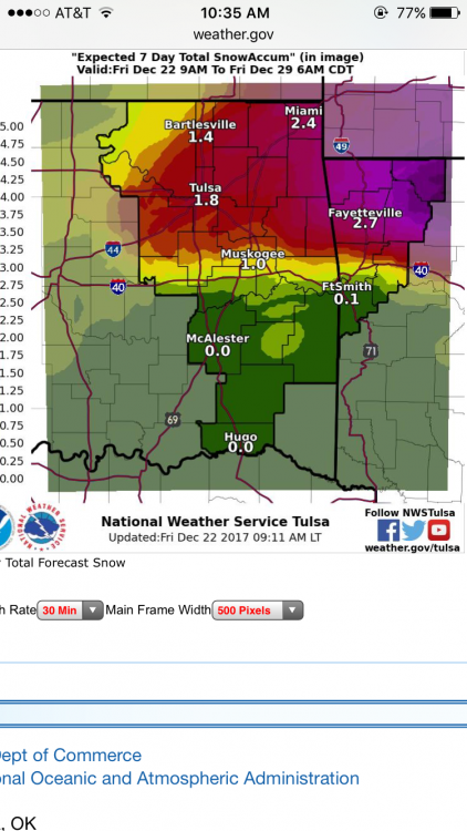
-
15 minutes ago, Weatherdemon said:
Tulsa NWS with a big bump in totals.
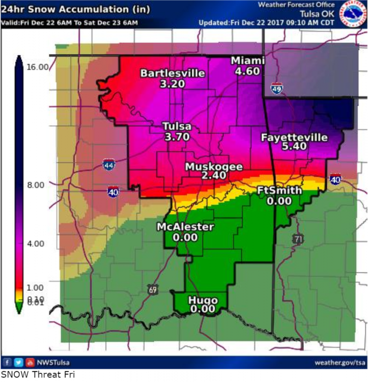
This is their 24 hour snow total, but their 7 day snow total has amounts of about half this. Not sure what the disconnect is.
-
Not sure how to link it, but doug goes with 1-3 for southern Missouri and northern Arkansas
-
12 minutes ago, Spot said:
Crazy GEM AND GFS mid/late next week system. To bad nothing close to any of that will happen.
Not saying it's going to happen, but the euro has a day 9/10 storm also.
-
23 minutes ago, GSwizzle83 said:
Hi all, wx24/7 here. Been trying for a couple of weeks to log in here with no such luck. So I created a new username.
Love how many of the tv mets last week were beside themselves about a Christmas Eve system who are now quickly dismissing it. Still too soon to know just exactly what the system will look like and the track it will take. Solutions have been all over the board. Looks pretty likely that it will be cold though. There is that agreement. Looking forward to tracking again this season!
I was wondering when you would resurface, almost texted you telling you to get back on here!
-
For anyone interested, the Little Rock AFD amazing tonight. Well worth the read.
-
8 minutes ago, Cerakoter1984 said:
Lezak's pattern doesn't work in years like this one until it's already almost too late.
Aren't Doug and his basically the same?
-
I've been reading what Doug Heady and Gary Lezak have to say about the Christmas system, and they couldn't be more different. Doug has kept the same tone for about a week now, and Gary had flip flopped every model run. Gary went from a 10% chance of a while Christmas, to a 55% chance back to a 15% chance in 24 hours. They both use the recurring cycle, but it's pretty obvious that Gary is just following the models for this one, while it seems Doug actually has faith in the recurring pattern idea.
-
11 minutes ago, JoMo said:
00z GEFS made the 00z GFS look like an outlier.
What has the euro been showing? Haven't had a chance to look lately
-
47 minutes ago, JoMo said:
Yep. Probably more to come as well.

Yep... what an insane run...

Absolutely crazy run
-
Looks pretty good, and fairly consistent for being 300+ hours out. Let's see how badly it can crush my hopes and dreams

MO/KS/AR/OK 2019-2020 Winter Wonderland Discussion
in Central/Western States
Posted
Seeing some reports of thunder snow in the Tulsa metro area.
Monett is getting sleet now. Pretty heavy and big in size