sbnwx85
-
Posts
1,933 -
Joined
-
Last visited
Content Type
Profiles
Blogs
Forums
American Weather
Media Demo
Store
Gallery
Everything posted by sbnwx85
-
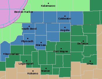
IWX issues watches. Pretty fun map. INZ003>005-MIZ077>079-160900- /O.NEW.KIWX.WS.A.0003.220217T1500Z-220218T0300Z/ La Porte-St. Joseph IN-Elkhart-Berrien-Cass MI-St. Joseph MI- Including the cities of Michigan City, La Porte, South Bend, Mishawaka, New Carlisle, Walkerton, Elkhart, Goshen, Nappanee, Niles, Benton Harbor, St. Joseph, Fair Plain, Benton Heights, Buchanan, Paw Paw Lake, Dowagiac, Cassopolis, Edwardsburg, Marcellus, Sturgis, Three Rivers, White Pigeon, and Mendon 406 PM EST Tue Feb 15 2022 /306 PM CST Tue Feb 15 2022/ ...WINTER STORM WATCH IN EFFECT FROM THURSDAY MORNING THROUGH THURSDAY EVENING... * WHAT...Heavy mixed precipitation possible. Total snow accumulations of 4 to 7 inches and ice accumulations up to one tenth of an inch. * WHERE...Portions of northern Indiana and southwest Michigan. * WHEN...From Thursday morning through Thursday evening. * IMPACTS...Plan on slippery road conditions Thursday afternoon and evening. The hazardous conditions will impact the evening commute.
-
South it goes now. Prepare for slight adjustment northwest 12 hours before storm starts. You gotta love the classics.
-
And wow is it south of GFS and NAM.
-
Focusing on my area and the American models: GFS keeps temps right at freezing during the icing event before temps drop and sleet occurs. Due to marginal temps and heavier rates, I think quite a bit of freezing rain would runoff and lower accretion. NAM and 3k NAM keep me around 30 during the icing portion of the event, increasing accretion. Winds will be an issue if any significant icing should occur. I’m 24 hours away from breaking out the “ice accumulation index chart”.
-
Can’t believe I’m asking this…but anyone have access to sleet accumulation maps?
-
I wonder if the 3rd place tv station is town is regretting branding the GHDIII Storm the “Storm of the Season” yet.
-

Winter 2021-22 Short/Medium Range Discussion
sbnwx85 replied to Chicago Storm's topic in Lakes/Ohio Valley
Four years ago in February, we had absolutely devastating river flooding across Michiana. It was caused by a foot of snow followed by several inches of rain a week later. I hope to never see that again…but the next two weeks are looking eerily similar. -
Starting to think I might reel this one in. Not sure yet on what type of frozen precip I’ll end up with, but looking like we’ll be dealing with a winter storm this week.
-
I got 10” from the last storm. I can’t remember the last time I got back-to-back big dogs. If for nothing else, it’s for that reason I think the one will go northwest of me. I’ll be pleasantly surprised otherwise.
-
Someone on Twitter went snow chasing the lake effect near Benton Harbor.
-
Light to moderate snow in one of the outer bands of the mesolow in SW Michigan.
-
Feeling some of the “outer bands” here.
-
Taking the run verbatim…that would be a lot of heavy snow on top of ice. Just a couple inches of snow after a couple tenths of an inch of ice causes problems. Nothing to get alarmed about at this stage in the game, but certainly something to keep an eye on.
-
For those keeping score at home, my first and final call of rain was for Wednesday. I haven’t made a decision for Thursday.
-
Nice burst.
-
Hoping this burst holds together for a few more minutes. ...A quick burst of snow with gusty winds to hamper travel... Snow was spreading across far southwest Lower Michigan into far northwest Indiana behind a cold front. Winds were gusting to between 40 and 50 mph and were causing reduced visibilities along with blowing and drifting snow. Temperatures will rapidly fall below freezing causing a fast deterioration of driving conditions with the likelihood of road becoming slippery. If you are traveling early tonight over areas north and west of South Bend, use caution. Allow extra time to reach your destination.
-
First and final call:
-
-
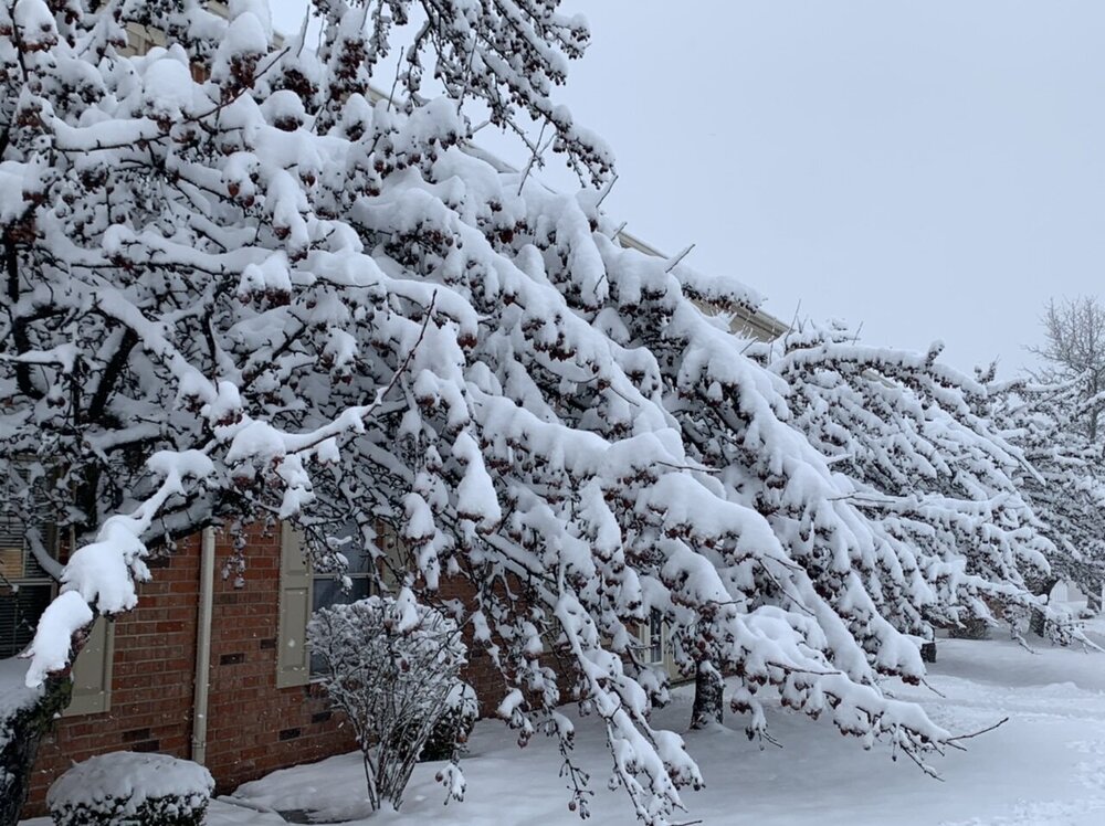
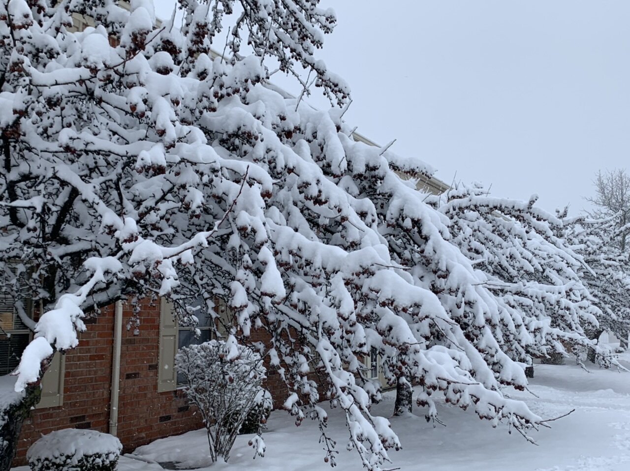
Light glaze covering everything when I got to the car this afternoon before work. Mood flakes now. A very wintry day.
-
Winter 2021-22 Short/Medium Range Discussion
sbnwx85 replied to Chicago Storm's topic in Lakes/Ohio Valley
HRRR and NAM picking up on a coating to an inch in N. IL/IN tomorrow evening. Just something to keep things fresh. -
Ended with somewhere between 9 and 11 inches depending on where I measured. The parking lot in my complex hadn’t been plowed when I got home tonight. The car got into a spot but it’s going to be a battle to leave tomorrow.
-
RECORD EVENT REPORT NATIONAL WEATHER SERVICE NORTHERN INDIANA 0450 PM EST WED FEB 02 2022 ...RECORD DAILY MAXIMUM SNOWFALL SET AT SOUTH BEND... A RECORD SNOWFALL OF 8.2 INCHES WAS SET AT SOUTH BEND TODAY. THIS BREAKS THE OLD RECORD OF 8.0 INCHES SET IN 1908. THIS WILL BE UPDATED AT THE END OF THE DAY WITH THE FINAL SNOWFALL TOTAL FOR THE DAY.
-
I haven't been able to go out and measure lately...but several 8.2" reports around South Bend at 3:00 EST.
-
A little over 6 now. Rates decreasing but hopeful things fill in on the radar.
-
4.75 inches so far. Very pretty. Death band incoming from the west.