

WinstonSalemArlington
-
Posts
2,091 -
Joined
-
Last visited
Content Type
Profiles
Blogs
Forums
American Weather
Media Demo
Store
Gallery
Posts posted by WinstonSalemArlington
-
-
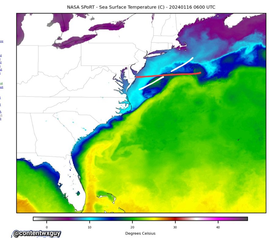
water temperatures
-
 1
1
-
-
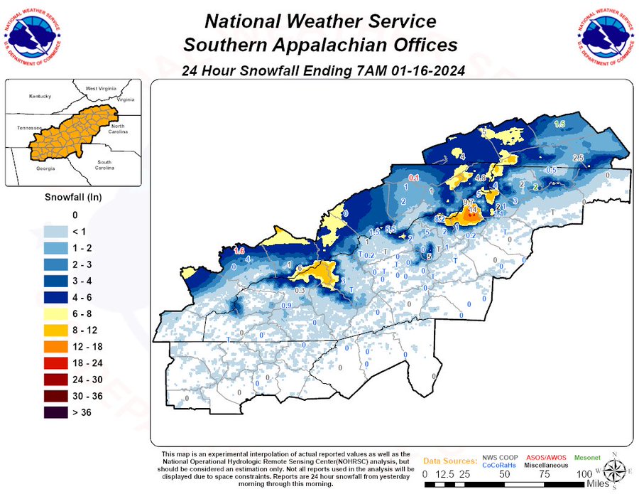
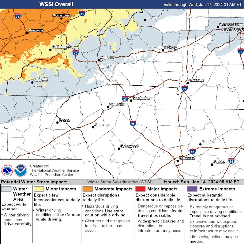
Not everyone in NC is snowless
-
Just now, WinstonSalemArlington said:
It’s interesting that the DMV has snow cover, but most of central North Carolina was colder than or as cold as much of the DC area this morning.
-
1 hour ago, NorthHillsWx said:
Pretty impressive lows considering there’s no snow cover
It’s interesting that the DMV has snow cover, but most of central North Carolina was colder than the DC area this morning.
-
11 minutes ago, JoshM said:
Time to open your windows by the end of the 0z GFS

Disgusting
-
27 minutes ago, mclean02 said:
I think it might have more to do with the southeast ridge slowing down heavy cold air plus the Appalachians
Brad P doesn’t think this is a case of the Appalachians blocking the cold. He says: “actually, no, this has nothing to do with the mountains. The flow is out of the Southwest, and it's colder and snowing to our southwest. It's just where the trough is located, and the moisture, so the mountains play no role in this.”
-
2
-
-
I don’t recall an Arctic plunge taking so painfully long to blast East. It cleared Nashville two days ago, and still hasn’t gotten past the mountains. We routinely have Summer cold fronts that blast through faster.
-
8
-
-
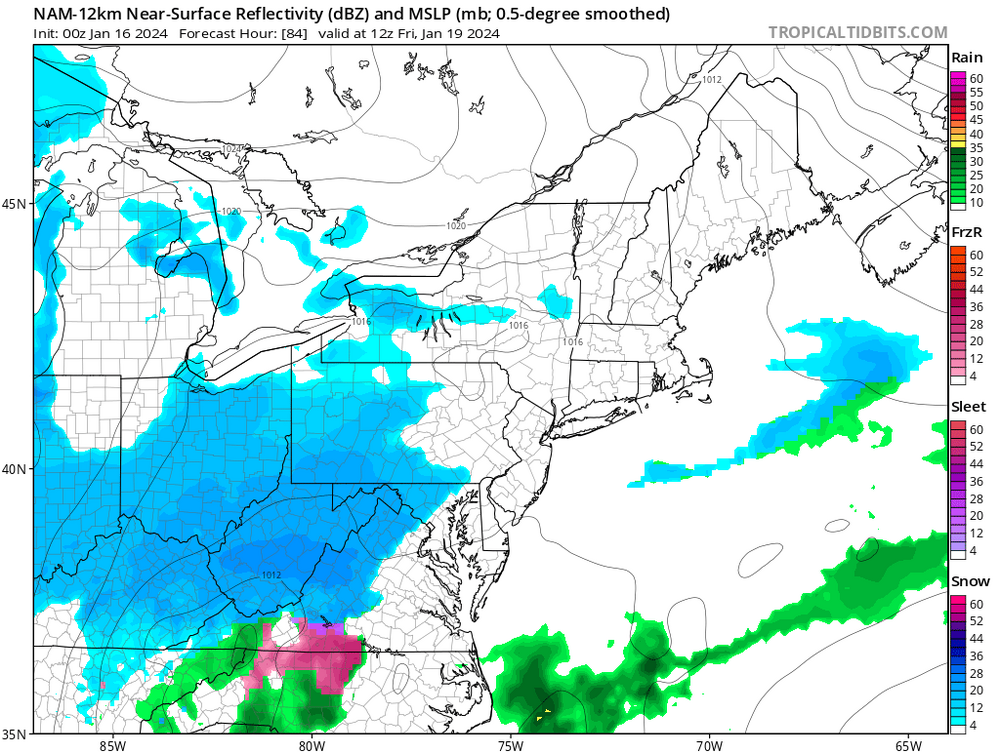
At least Roanoke, Richmond, and mountainous Northwest North Carolina got some decent snow.
Until we get a western ridge, I am not hopeful for the Triad. We need the Eastern trough to be off the Mid-Atlantic Coast, not along the mountains.
-
1
-
-
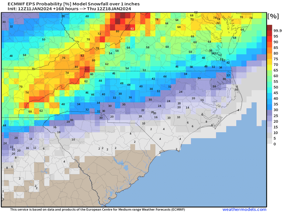
I fairly understand why the cold delivery had failed so far, but I don’t get why the moisture delivery has also failed. GSO has only had a piddling .02 inches out of this entire system. Is it downsloping? But why did Central Virginia and Northern VA get more precip?
-
1
-
-
What even is
-
 2
2
-
-
32 minutes ago, GaWx said:
Per met Alan Huffman's surface compilation of major RDU snowstorms (not talking about ice or sleetstorms meaning sig CAD not necessary)
-best bet is for an Arctic high center, preferably strong and sprawling, to come down into the Dakotas as opposed to further west, which allows for cold enough air to soon after reach the SE in advance of potential precip.
-as opposed to waiting longer for more modified/stale cold first coming into the W, which also often has trouble getting over the Apps
-as opposed to a plunge of the high down into TX/AR/LA, which is often the coldest option but is also usually too dry to allow for moisture return into the lower levels prior to a warmup; high plunges like these often result in extreme cold/dry followed by too rapid a warmup due to warming on the backside of the high
-and then for the large Dakotas high to move SE, ESE and then E through the Ohio Valley thus hopefully still keeping it cold enough in the SE at least as high as 850 mb (with or without significant CAD)
-at the same time you want moist WSW to SW 500 mb flow over the top of the lower level cold in the SE US while the Arctic high is still in/near the Ohio Valley. If the 500 mb flow over the SE is instead WNW or even W, it usually is too dry in the SE for a big storm if any storm at all
-timing is obviously crucial being that big SE snows are infrequent
-best bet at 500 mb is for a split flow of the N stream bringing down but not plunging the Arctic high combined with a moist S stream simultaneously bringing in plentiful moisture from the Pacific and especially Gulf over the top of the S extent of the Arctic high
-more specifically, a +PNA with a 500 mb trough centered near the Mississippi River is what I look for
-Most of the memorable major SE snowstorms are associated with a weak to very weak GOM surface low that doesn't go too far inland, if inland at all other than over FL. These are usually Miller As.
Thanks so much
-
1
-
-
1 hour ago, Leesville Wx Hawk said:
Need ridging in the west via Aleutian low (+PNA) so that cold air from Canada can move SE into our region. This should happen in about 2 weeks hopefully.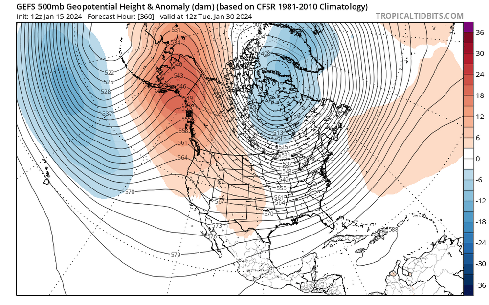
12 Z GEFS ensemble shows a ridge in the west that pushes the SE ridge. While not perfect, this is a better synoptic pattern for our region and something to follow moving forward.Thanks for explaining
-
Could someone explain to me what it takes for Arctic fronts to enter the States in the East instead of the West. It’s clear that’s polar invasion that includes Portland is going to be underwhelming here.
-
-
We need the Arctic plunges to enter the US in the East, not the West or Plains to eliminate the need for cold to get over the formidable Appalachians.
-
3
-
-
-
-
-
-
-
DT: “
Any system that does develop is going to be weak track well to the south and east of Cape Hatteras and will not become a significant East Coast winter storm in any way shape or form.
It is possible however that there could light snow which could accumulate 1 to 2 inches in Northeast North Carolina Southeast Virginia (away from the coast) and Central Virginia in and around Richmond up across the Middle Peninsula, the Northern Neck and the Delmarva.
But even THAT is iffy as this is such a weak and diffuse system that is quite possible that nothing will fall but flurries. Further to the North and the big cities from Washington DC up to Boston this is a big fat zero.”
-
1
-
-
1 hour ago, NorthHillsWx said:
I really feel like if it’s going to happen in central NC, it will not be from Tuesdays storm, but the system on the 20th. Tuesday is cold chasing moisture at best for most of the piedmont and that just doesn’t end well here. The 20th intrigues me. Cold will be entrenched and I do not think any models have a handle on that energy yet
Do you include the Triad in “central NC?” There are some people here who do not for some reason.
-
-


Mid to Long Range Discussion ~ 2024
in Southeastern States
Posted
Phenomenal post!