

dWave
-
Posts
1,951 -
Joined
-
Last visited
Content Type
Profiles
Blogs
Forums
American Weather
Media Demo
Store
Gallery
Everything posted by dWave
-
July 2020 General Discussions & Observations Thread
dWave replied to Rtd208's topic in New York City Metro
Low was 77, now 89 -
It really did..but its sounded like that for over a month now so it kind of wore out its welcome for me tbh.
-
July 2020 General Discussions & Observations Thread
dWave replied to Rtd208's topic in New York City Metro
Makes sense, I never gave it much thought. I always think about upswellings effect in water temps. Dew point shot up last hr. Low 50s to around 70. Temp down to 88. Dry mid 90s felt better. Actual 95 more tolerable than heat index of 95. -
July 2020 General Discussions & Observations Thread
dWave replied to Rtd208's topic in New York City Metro
I went to Robert Moses, fairly warm (around 80?) and quite humid down there. Could feel the heat more in western Nassau and a wall of heat that put AC to the test north of the LIE into the BX. 95 here but a dew point 54. On a side note I cant remember ever seen waters so turquoise around here, alot of ppl were marveling at it. -
July 2020 General Discussions & Observations Thread
dWave replied to Rtd208's topic in New York City Metro
The cool 96 summer was like the historic 95-96 winter refusing to fully let go. -
July 2020 General Discussions & Observations Thread
dWave replied to Rtd208's topic in New York City Metro
After the rain down to 77..dew 76 Park got to 90. -
July 2020 General Discussions & Observations Thread
dWave replied to Rtd208's topic in New York City Metro
missing the heavy stuff..mostly cloudy drizzle/light rain 90 after high of 92. -
July 2020 General Discussions & Observations Thread
dWave replied to Rtd208's topic in New York City Metro
90 here -
July 2020 General Discussions & Observations Thread
dWave replied to Rtd208's topic in New York City Metro
Some breaks of hazy sun now 88/71 -
July 2020 General Discussions & Observations Thread
dWave replied to Rtd208's topic in New York City Metro
Cloudy..temps rising slowly, 86 dew 70. -
July 2020 General Discussions & Observations Thread
dWave replied to Rtd208's topic in New York City Metro
80, after low of 79. -
July 2020 General Discussions & Observations Thread
dWave replied to Rtd208's topic in New York City Metro
Sea breeze right at the immediate shore. Wind went south. Thought they might make it, saw 88 at one point. 94 here -
July 2020 General Discussions & Observations Thread
dWave replied to Rtd208's topic in New York City Metro
LGA up to 93. Meanwhile, Central Park went down to 88 ? -
July 2020 General Discussions & Observations Thread
dWave replied to Rtd208's topic in New York City Metro
92 dew 64. 5th 90+ of the season -
July 2020 General Discussions & Observations Thread
dWave replied to Rtd208's topic in New York City Metro
Not a cloud in the sky, 83 dew 66. On track for NWS forecast of 90 -
June 2020 General Discussions & Observations Thread
dWave replied to Rtd208's topic in New York City Metro
The worst of that t storm missed to my west and SW but i got a rainbow. Over E Tremont Av in Parkchester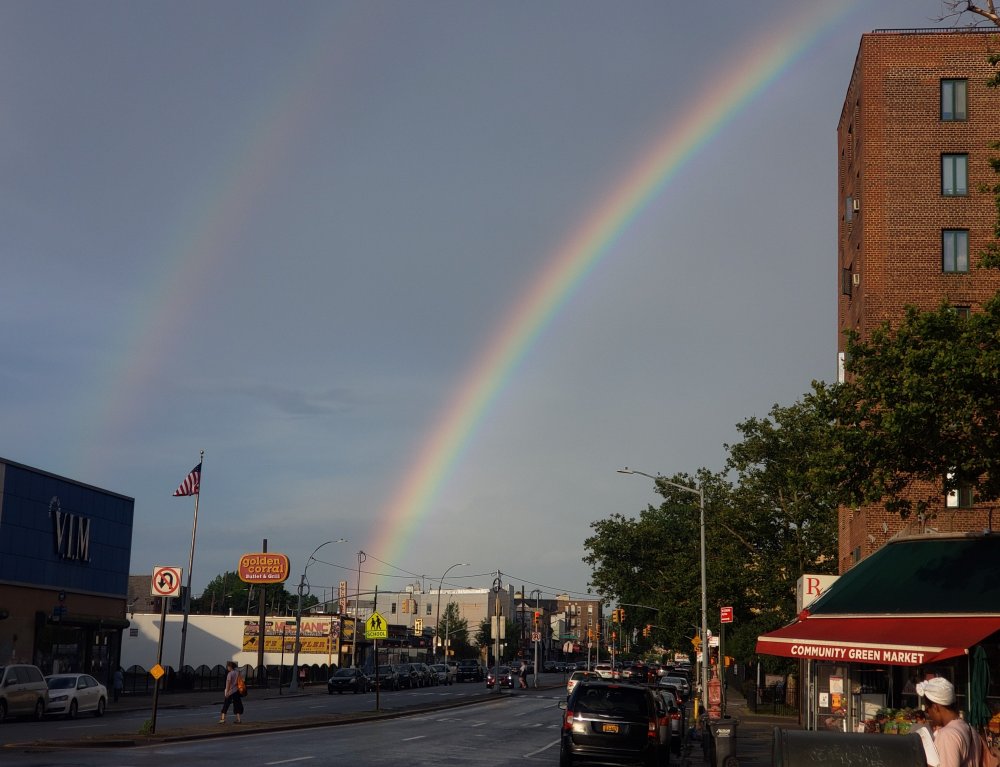
-
June 2020 General Discussions & Observations Thread
dWave replied to Rtd208's topic in New York City Metro
In the bx..Look like it was about to pour but just light rain with some gusty winds,lots of lightning but worst of it look like it shifted just west headed down Manhattan. -
June 2020 General Discussions & Observations Thread
dWave replied to Rtd208's topic in New York City Metro
T storm incoming, lots of lightning looking north The sound of thunder and the endless fireworks, M 80s etc here is an interesting mix. -
June 2020 General Discussions & Observations Thread
dWave replied to Rtd208's topic in New York City Metro
Today might be JFK warmest day so far, with a off shore wind -
June 2020 General Discussions & Observations Thread
dWave replied to Rtd208's topic in New York City Metro
actually pushing 90 again here. Steady at 89 for a while. No rain or rain cooled low temps yday helps -
June 2020 General Discussions & Observations Thread
dWave replied to Rtd208's topic in New York City Metro
Mostly cloudy 88 dew 66 after a high of 92. A few distant rumbles of thunder, but saw some dramatic lightning strikes looking north. Was briefly on the roof but then got the hell off. Also looks very ominous looking toward Westchester while some sun shines looking toward LGA. -
June 2020 General Discussions & Observations Thread
dWave replied to Rtd208's topic in New York City Metro
Party cloudy 89/70. HI 94. Touched 90 a few times. -
June 2020 General Discussions & Observations Thread
dWave replied to Rtd208's topic in New York City Metro
Warming up quick. warm, humid morning 81 dew 72, HI 85 -
Suns out, 81 dew 71
-
Moderate rain now 81.

