

The Iceman
-
Posts
11,638 -
Joined
-
Last visited
Content Type
Profiles
Blogs
Forums
American Weather
Media Demo
Store
Gallery
Posts posted by The Iceman
-
-
Yawn, winter is over. Bring on the warmth.
-
 2
2
-
-
Just under 4” here and no shoveling needed, win-win all around. Pleasantly surprised waking up. Things looked super meh when i went to bed at 1 am. Winter now graded at a D+ as opposed from a D. Still 8” away from average. LV is the snow capital of the east coast this year…
-
1
-
-
59 minutes ago, Blue Dream said:
Haha same, I was planning a 4am wake and bake but maybe not.
Bro can I come join? We can toke our sorrows away
")
-
 1
1
-
 4
4
-
-
18z NAM further decreases totals in extreme SE PA and South-Central jersey. Trending towards another melted by noon storm.
-
1
-
-
I'm 100% getting into that narrow subsidence zone have already accepted it, also why I'm not staying up lol
-
1
-
-
12 minutes ago, ChescoWx said:
Last 2 HRRR starting to step back on snow totals especially the further south and east from earlier runs -something to watch!

Fake news
-
4
-
-
18z NAM... everybody happy!

-
5
-
-
3 minutes ago, LVblizzard said:
Was March 7-8 the storm that knocked out power to much of eastern PA? I remember that clearly, I was in the Poconos for it and the forecast was 1-3”, instead we got over 6” with blizzard conditions at times.
Yup! One of my favorite storms the last 10 years. I'm actually pretty sure temps were above freezing the entire event IIRC at least down here by 95.
-
11 minutes ago, Kevin Reilly said:
I was 9 years old in that storm in 1983, but I think this is a wee bit different set up. This trend here is unprecidented, fun, unexpected but the temps???
HRRR is 32-34F during the heaviest rates...that'll definitely accumulate regardless of how warm it has been leading up to the storm. This sort of set up reminds me of March 7-8th 2018... we were light rain until the heavier echoes moved in then BAM 5-6 hours heavy snow/thundersnow..all surfaces caved despite temps 32-34 during the day...got 9 inches of concrete at 6-7:1 ratio's.
-
1
-
-
6 minutes ago, LVblizzard said:
Zoomed in HRRR. I think the entire subforum would be happy with this!
-
17z RAP and still thumping at that hour...I believe!


-
 1
1
-
-
Uncle UKIE goes even further south now with a SNJ jackpot lolz
.png.1984198fcebd42430e9760638cbd6bc6.png)
-
2
-
-
I'd be happy with a slushy inch, won't believe anything more until I see it...
-
1
-
-
Pretty interesting trend on the EPS from 12z yesterday to today(stolen from the mid atlantic forum).

If I lived in the LV/Pocono's, i'd be getting excited.
-
Well we have the wiggum rule going for us with temps soaring above 60 on Saturday...
-
1
-
-
1 hour ago, Duca892 said:
Can I ask a really novice question? Everyone’s hyping up this pattern change, but when will that be reflected with storm chances in the LR? It just looks rainy and warm?
Not sure what you're looking at TBH. 06z GFS A. doesn't even look all that "warm" unless you consider mid 40's "warm"...there's one day past day 10 that possibly gets into the 50s but who knows at that range. B. It doesn't look all that wet either save for a few showers tomorrow. The next major synoptic threat isn't until Feb. 15 which is likely the table setter for the pattern change. It's really not far off from a snowy solution but it's also 330 hours out so really no use hammering details at that range. First half of the month looks mostly slightly above normal temps(again mostly in the 40's) and dry. The storm on the 15th will likely be the first "threat" in the new pattern that could be wet or white, details TBD as it's 14 days out...the best potential lies after the 15th if LR ensemble guidance is to be believed at this range.
-
1
-
-
I think the first half of Feb is about the worst possible winter pattern imaginable. Still cold and raw enough to not really be able to enjoy the outdoors but not cold enough for any snow threats, just endlessly slightly above normal temps(upper 40's) with zero snow chances. 2nd half of the month still looks on track to get into a better pattern but how much staying power will it have? Thinking it ends up being similar to the January good pattern. 10-14 days with multiple legit threats and hopefully we land 1 or 2 to get us close to average on the year. After that though, likely on to Spring...
-
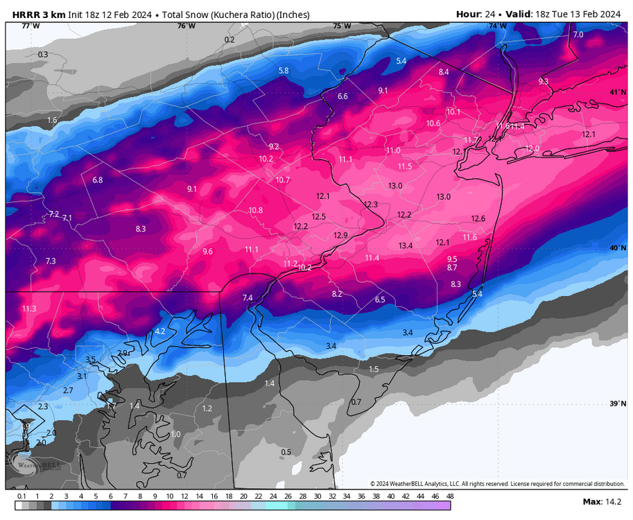
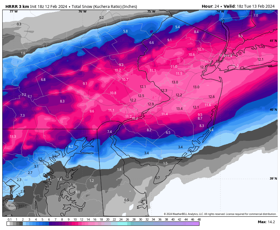
12z euro gets accumulating snow even down to the 95 corridor. I think you may have to cut the totals on the clown map in half down there due to the changeover from rain and surface temps but would still be a decent event for many. As Newman said, LV gets absolutely pasted:

-
1
-
1
-
1
-
-
Finally tapering off to light snow now.. currently at 4.6”. Don’t think we get to 5” but this was an enjoyable storm! Kudos to mt holly, their snow map was pretty bang on from even their first call. Hope this shows people there is more to snow forecasting than reading model clown maps.
-
1
-
1
-
-
Just crossed 4” in Levittown
-
2
-
-
Up to 2.5” here now, this band is delivering the goods.
-
1
-
-
1.2” of pure powdah so far. Currently in between bands with light snow. Radar looks great for se pa into south and central jersey.
-
2
-
-
1 minute ago, greenmtnwx said:
Where is the NWS coming up with these 6-7” forecasts in monmouth and ocean county? Every piece of modeling indicates 2” maybe abs have been getting drier?
Read the AFD, it explains it pretty well.
-
3
-
-
From the most recent AFD
QuoteBands of heavier snow may enhance the wet bulb effect, resulting in colder surface temperatures and higher liquid to snow ratios. This will result in locally higher snow amounts. Overall, liquid to snow ratios will be on the order of 14:1 to 17:1, but could get as high as 20:1.Straight powdah as they say up north. That would also explain the higher projected totals area wide than what some of the models are spitting out on the clown maps.
-
2
-

E PA/NJ/DE Spring 2024 OBS/Discussion
in Philadelphia Region
Posted
We're heading into another Nina, might want to countdown to fall 2025.