

Weatherdemon
-
Posts
401 -
Joined
-
Last visited
Content Type
Profiles
Blogs
Forums
American Weather
Media Demo
Store
Gallery
Posts posted by Weatherdemon
-
-
31 minutes ago, MoWeatherguy said:
Yah man all well here. Just trying to temper my excitement after all these dud winters. Its paying off so far lol.
It’s killing me. This storm as modeled has been brutal.
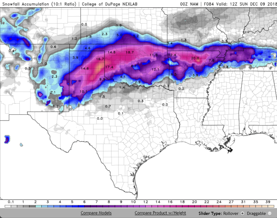
NAM says 2-3 for Tulsa now and the 3K likes 3-4 so, I guess that’s something to hold me over until the next heartbreak run.
-
 1
1
-
-
Just now, ouamber said:
For Fallin to declare a state of emergency for this is just about the biggest bust for Oklahoma!
Just saw that? Seems strange...
-
9 minutes ago, Wx 24/7 said:
No more looking at a potential storm until 24 hours out.

Seriously...
Exremely frustrating.
-
12z GFS and NAM pretty warm.
NAM still "cold enough" for 3-5.
A lot of things can still happen but I'll forever hate the GFS if it nailed this several days out... I don't care for it as it is as it always lets us down... now in both ways, LOL.
-
1
-
-
Tulsa NWS
Benton-Carroll-Washington AR-Madison-Crawford-Franklin-Osage-
Washington OK-Nowata-Craig-Ottawa-Pawnee-Tulsa-Rogers-Mayes-
Delaware-Creek-Okfuskee-Okmulgee-Wagoner-Cherokee-Adair-Muskogee-
McIntosh-Sequoyah-
Including the cities of Rogers, Bentonville, Berryville,
Eureka Springs, Fayetteville, Springdale, Huntsville, Van Buren,
Ozark, Charleston, Pawhuska, Bartlesville, Nowata, Vinita, Miami,
Pawnee, Tulsa, Claremore, Pryor, Grove, Jay, Sapulpa, Okemah,
Okmulgee, Wagoner, Tahlequah, Stilwell, Muskogee, Checotah,
and Sallisaw
429 AM CST Thu Dec 6 2018
...WINTER STORM WATCH IN EFFECT FROM LATE FRIDAY NIGHT THROUGH
SATURDAY EVENING...
* WHAT...Heavy mixed precipitation possible. Total snow and sleet
accumulations of 1 to 3 inches, with localized amounts up to 6
inches, and ice accumulations of up to two tenths of an inch are
possible. The most likely area for the locally heavier snow
amounts will be over the higher terrain of northwest Arkansas.
* WHERE...Portions of east central, northeast and southeast
Oklahoma and northwest and west central Arkansas.
* WHEN...From late Friday night through Saturday evening.
* ADDITIONAL DETAILS...Plan on difficult travel conditions.
Significant reductions in visibility are possible -
19 minutes ago, ouamber said:
Does anyone get the UKMET?
Only at 15z Thurs right now
-
-
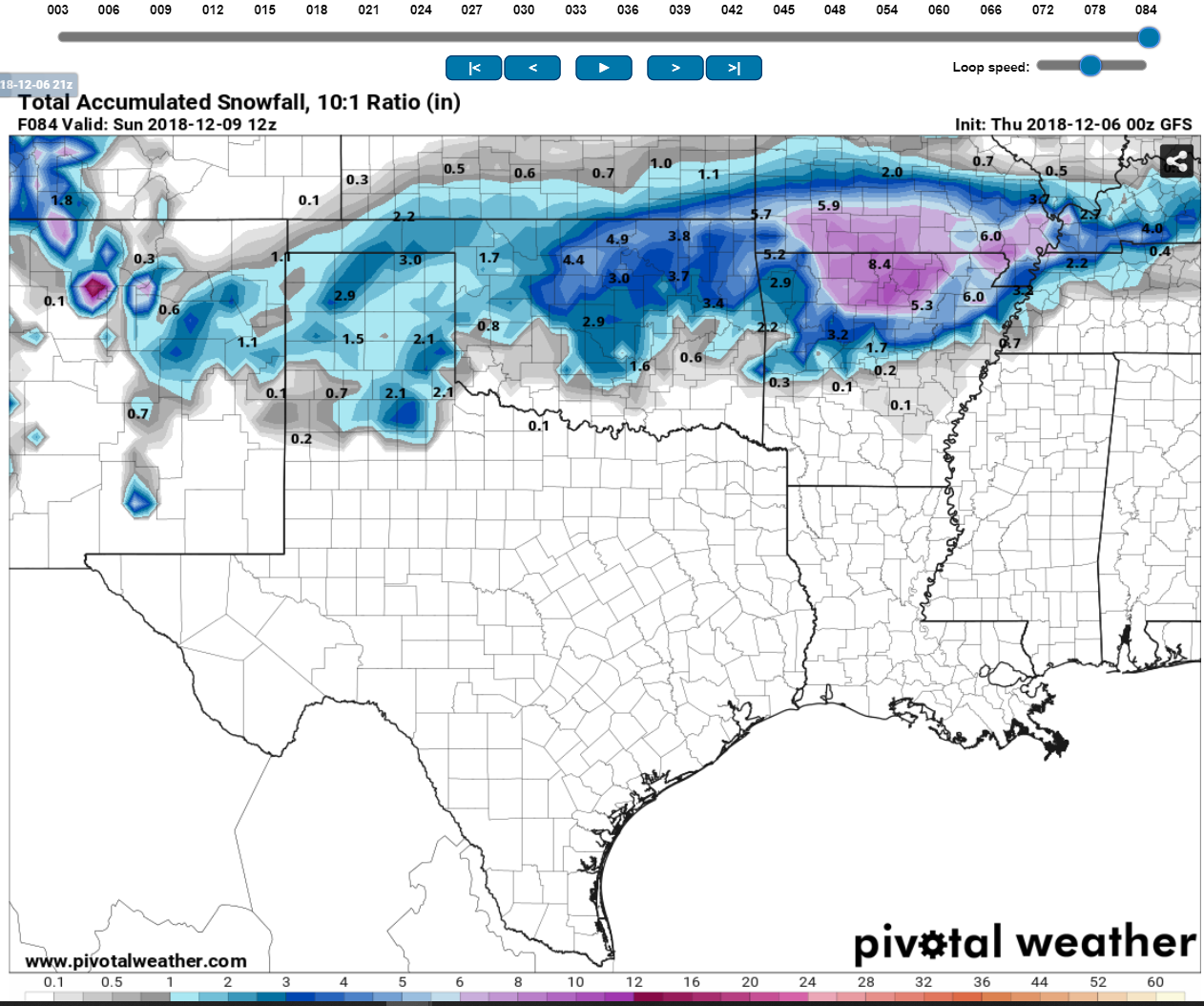
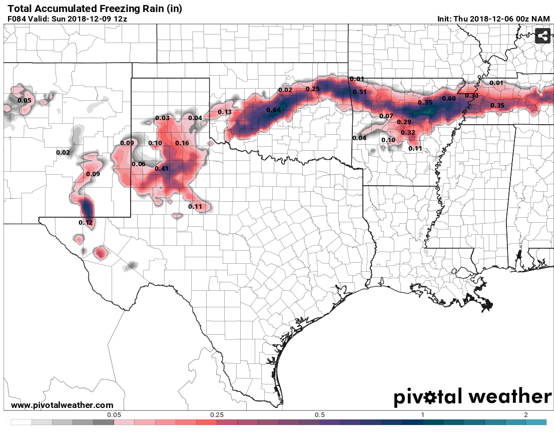
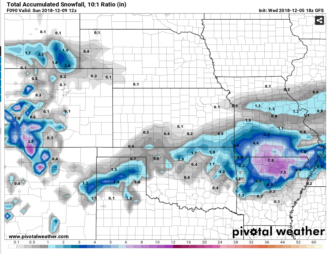
GFS at 3.3 inches by 21z Sat in Tulsa. That's already 2 inches more than previous run.
-
Tulsa NWS needing more data before issuing watch.
Area Forecast Discussion
National Weather Service Tulsa OK
933 PM CST Wed Dec 5 2018

...UPDATE...

.DISCUSSION...
A rather wide range of temperatures was observed this evening,
with low dewpoints/light winds allowing a few spots to quickly
fall below forecast lows already. Have generally lowered temps
across most of the area the remainder of the night, although
increasing clouds should keep lows from completely bottoming out.

Quick look at the 00Z NAM doesn't clear up the winter weather
potential, as it maintains a band of significant snow/sleet northwest
of I-44 with a secondary max across parts of northwest AR. NAM has
been consistent with previous runs but also a significant outlier
as far as amounts go. A winter storm watch will likely be needed,
but don't have the confidence yet to put one out without seeing
more 00Z data/model runs
-
-
Wow.
NAM still not backing off.
-
3 minutes ago, JoMo said:
So, NCEP is having data issues?
Don't know but, the NAM just kicked off
")
-
Damon Lane calling for 3-6 across the expected areas and 6-12 for parts of western OK almost to Enid and Stillwater. OKC metro in the 3-6.
-
3-6 seems to be the generally accepted amounts for Tulsa at this time.
-
25 minutes ago, StormChazer said:
Where did you find this???
Mine is a screenshot from the YouTube update.
-
2 minutes ago, StormChazer said:
Pretty surprised Tulsa hasn't issued the watch yet....and this evening's NAM run is going to be a very important one as it'll have more information to go off of.
CH 9 in OKC has 4-8 inches from SW OK through NE OK. Width covers virtually all of NE OK. along with .25 of ice in the same area.
-
OUN Discussion:
Area Forecast Discussion
National Weather Service Norman OK
405 PM CST Wed Dec 5 2018.DISCUSSION...
We have high confidence in impactful winter weather across the
forecast area. The main changes were 1) to confined to precipitation
chances to southern portions of the area through early Friday
morning, and limited probabilities across northern Oklahoma until
late Friday/Friday night, 2) to make minor adjustments to ice
accumulations and amounts, 3) increase snow amounts across portions
of western and northern Oklahoma, 4) increase precipitation
probabilities, and 5) significantly lowered post-event temperatures
Sunday into Monday given expected snow cover.Low level saturation near/behind the cold front tomorrow doesn't
appear to be sufficient for drizzle or freezing drizzle but we'll
need to watch the trends in the observations. Further south, deeper
moisture and a more pronounced near-surface saturated layer below
capping warm/dry layer may yield some drizzle. Temperatures there
will be warm enough for no freezing concerns. For post-frontal
temperatures through Friday we went with the low end of model
guidance (NAM, WRF-ARW) which seems most reasonable given the
pattern and character of upstream cold/dry cP air mass.Models are in fairly good agreement with synoptic scale features. A
closed mid-upper low will move across the Southwest tomorrow night
and Friday and through the southern Plains Saturday. Large scale
ascent and deepening moisture will eventually lead to light
precipitation across the area, but it's onset, amounts, and
resultant impacts from icing are probably the most uncertain part
of the forecast at this point. There will be a west-southwest to
east- northeast corridor of potentially impactful icing, including
the possibility of tree and powerline damage as well as travel
problems. This would be commensurate with icing amounts that
approach or exceed 0.25 inches Friday and Friday night, and
appears to be most likely across southwest Oklahoma extending up
near and south of the I-44 corridor. We may need to adjust the
highest chance of freezing rain further south from current
graphics based on the latest model forecast soundings which show a
deeper cold layer across the northern half of the area supporting
just light freezing drizzle, and eventually sleet once dendrite
probabilities increase through saturation <-12C. It's also worth
noting that our cold NAM/ARW hourly temperatures may not be cold
enough and at least low-end icing event may evolve further south
than earlier thought, to around the Red River and into western
north Texas.Where freezing rain does occur, accretion should be tempered by
latent heat release where temperatures are at or just below
freezing. But, 10-15 knot northeasterly winds may help offset that
some. So fairly optimal ice-to-liquid ratio according to the FRAM
model could develop. Again, potential rainfall amounts will need to
be monitored closely. Fortunately, this is not expected to be the
most optimal scenario for significant icing which would occur with
colder temperatures and higher QPF amounts.We trended more aggressive with sleet potential given strengthening
warm nose aloft and it's possible that sleet could at least briefly
be the dominate precipitation type in a band from southwest/west-
central Oklahoma eastward along and either side of the I-40
corridor, especially Friday evening and overnight. Saturday morning,
as the closed low passes to our south cooling aloft will support all
snow. There are some model differences by then with regards to the
degree at which the low becomes closed. However, ECMWF matches well
with its ensemble mean counterpart, and the spread in GEFS members
is minimal for this time range as well. Deterministic GFS matches
this reasonably well, and the GFS-FV3 is slightly more closed
off/anomalous. All this is to say that although some slowing or
slight variations in track could alter ptype placement and amounts,
overall confidence is fairly high given that the peak of the event
is about 3 days out.The aforementioned described synoptic setup is favorable for
development of a pronounced TROWAL and deformation snow event as
the deep low passes south and southeast of the area. One potential
limiting factor for more robust snowfall amounts could be mixing
of sleet given currently depicted thermal profiles, but current
thinking is that models could be too aggressive with this and a
longer duration of moderate to heavy snow could form across
portions of the area. 2-4 inch snowfall amounts should be common
across much of the area (especially the northwest half), and there
could be a band of 6+ inches given impressive QPF amounts that
have been consistent in models.We lowered temperatures after the system departs given likely snow
cover.BRB/PW
-
1
-
-
1 minute ago, Wx 24/7 said:
There is more than enough in that graphic to prompt TSA to issue a Winter Storm Watch. Wonder if they are waiting to analyze the 00z data first?
Their discussion below. No mention yet but I would bet you're right.
A
rea Forecast Discussion
National Weather Service Tulsa OK
322 PM CST Wed Dec 5 2018.DISCUSSION...
The big story continues to be the potential for wintry
weather Friday into Saturday. Winter weather headlines
will likely be needed as impactful weather is expected
across portions of eastern Oklahoma and western Arkansas.A cold front is slated to move through eastern Oklahoma
and western Arkansas on Thursday with the potential for
rain in the vicinity of the boundary as it moves through
the area. Temperatures will be noticeably cooler on Thursday
behind the cold front.The precipitation shield will begin to return to the north
on Friday as isentropic lift increases north of the frontal
boundary as it continues to sag south toward the northern
Gulf of Mexico. Some of the precipitation along the north edge of
the precipitation shield may fall as a wintry mix of freezing
drizzle and light snow Friday.The potential for wintry weather really ramps up later Friday
night into Saturday as an upper level moves out of the Southwest
United States and across the Southern Plains. With this forecast
Package went with slightly colder surface temperatures than the
blended model guidance provided and an even blend of the GFS,NAM12
and ECMWF thermal profiles. Stayed fairly close to the WPC QPF
with a small increase Saturday Night as a nod to the slower moving
ECMWF. A wintry mix will transition to mostly all snow across the
majority of the area by Saturday Evening as the cold air deepens
before ending Sunday Morning.Of course, it is still early to give any real specific amounts of
snow and ice. However, it is looking more likely that there will be
impactful amounts of snow and ice across much of northeast Oklahoma
and northwest Arkansas Friday Night into Saturday. It all depends on
the ultimate track and strength of the upper level as it moves across
the Southern Plains.As we move into next week high pressure will build at the surface
and aloft resulting in a slow warming trend across the region. -
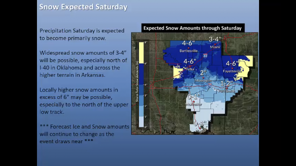
Here is a good Tulsa NWS graphic.
-
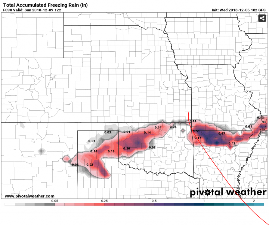
GFS starting to cool off. Pretty decent change in snow but ice about the same as last run.

-
25 minutes ago, JoMo said:
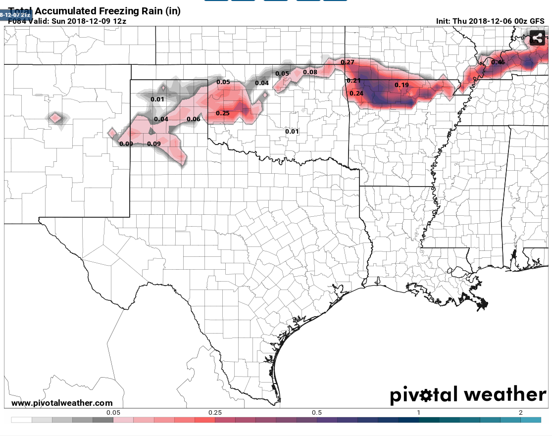
The NAM usually overdoes precip amounts. Don't get your hopes up, yet. Pretty to look at, but it is the NAM.
I know. I really expected it to begin its stroll into reality this run, not flip out more, LOL!
-
I haven’t looked but I thought this run was supposed to have inland measurement data and ideally be more accurate?
-
54 minutes ago, StormChazer said:
Was asking that myself haha
My bad guys.
Was on F5 and it said 12z but was old frames.
Yea, I'm fired....
Thanks for posting the right one!
-
2
-
 1
1
-
-
12z Euro still looks good for 4-6 in Tulsa.
Not a lot of change from the previous run.
Keeps things liquid until late Sat morning S of I44 in NE OK.


MO/KS/AR/OK 2019-2020 Winter Wonderland Discussion
in Central/Western States
Posted
Ugh, yes.
I think I hate it even more now though... GFS
GFS