

Weatherdemon
-
Posts
401 -
Joined
-
Last visited
Content Type
Profiles
Blogs
Forums
American Weather
Media Demo
Store
Gallery
Posts posted by Weatherdemon
-
-
Excellent point on snowpack! I haven’t looked at that this morning and I should have!
-
Good stuff! Thanks!
FWIW... Tulsa NWS mentioned it at the end of their morning AFD.
Your Tigers may have a long tonight with lightning delays vs the Trojans if tonight's forecast pans out.
-
Starting to feel more like an icing event with some light snow on the back end.
GFS has tracked further N and keeps most precip liquid.
v3 puts down most of the precip as ice in some form generally NW of I44.
Euro puts down some decent snow of 3-7 inches along I44.
Canadian more in line with the GFS.
Less track agreement this morning but still general agreement on the system and it's potential winter impacts so that's good.
-
I like the general agreement amongst at least 6 models for a winter system for parts of OK during this time.
Hope it becomes a matter of how much here and not how close it will be. Would prefer to not have ice though.
-
 1
1
-
-
11 hours ago, jojo762 said:
After these few nondescript Slight/Marginal Risk days we've had across the plains with what once looked like a conditionally promising system, we appear to be headed for an incredibly boring period of unremarkable weather systems and below average temps, followed by possibly above average temps for a brief period and more unremarkable systems. There seems to be no real chances for S/W flow across the Central or Southern plains for the foreseeable future, likely well into April.
Ugh... just took a look at the models and this simply sucks.
-
-
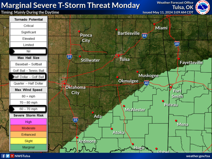
Tulsa NWS posted this earlier
-
Temps running about +1 compared to the 17z HRRR.
HRRR doesn't typically overdue freezing rain from what I remember.
-
Not confident in precip amounts or temp.
I would lean toward colder than shown for sure.
-
Got a glaze up here but it looks like the precip is shifting east faster than models indicated
-
3 minutes ago, JoMo said:
Hanging around 33-34 here. HRRR has come in a bit more concerning in the coming hours when it comes to icing.
Wouldn't surprise me to see some freezing drizzle sticking around after the main rain shield moves east tonight.
-
10 minutes ago, ouamber said:
33 in downtown Tulsa right now..temps are hanging on, but not sure for how long. Back windshield of my car is getting a glaze.
Seriously? Wow
-
42 minutes ago, StormChazer said:
I'm starting to think we may get some ice storm warnings issued to the NW of Tulsa Metro area. Down in DFW they extended their flood watch to the west because their expecting that heavier precip to shift some to the west, if that plays out, that area of precip will make its way up to NE Oklahoma after the freezing temps are in place. Just my two cents.
Pics on Twitter in Stillawater water showing what looks like near 1/2 inch of ice on trees
-
Tulsa NWS with a new Winter Weather Advisory basically along and NW of I44.
31.4 degree drop just S of Collinsville since 7:35. Temp now at 38.2
-
And now from 69.6 to 49 in 18 minutes
-
1 hour ago, NJ_Ken said:
The front has been literally hovering in my backyard all night. It was 44 F when I went to bed. It is now 68 F. El Reno and Guthrie, both less than 30 miles away, are at 37 F!
Edit: and just like that, the front is heading south again. Literally minutes later, it is back down to 37 F in my backyard on the north side of OKC.
Wild ride at my house last night....
-
3 hours ago, GSwizzle83 said:
And just as the NAM and GFS begin to move toward the EURO solution... it sort of changes. Will be interesting to see if the EURO's moves are a one run thing or the beginning of a new trend. I am personally okay not receiving 1"+ of ice.
Neither am I.
Tulsa NWS sticking with hundredths of an inch but no amount of freezing rain is good.
-
NAM hammering parts of E OK Tues night into Wed with accumulating freezing rain to 1.39 inches.
-
15 hours ago, Weatherdemon said:
Late next week has gotten the attention of local Mets and Tulsa NWS.
Looks like there is potential for as much as a 1/2 inch of ice. Not devastating but would be significant pain.
&^%$#
Models hung on until Sun AM and now doing their thing and killing it... which has been accurate this close but still frustrating.
-
Late next week has gotten the attention of local Mets and Tulsa NWS.
Looks like there is potential for as much as a 1/2 inch of ice. Not devastating but would be significant pain.
-
Left downtown around 3:15 and the IDL was really slick.
HWY 75 N had slick bridges and a couple wrecks. One closed 75 SB.
51 west was closed for a bit too.
Sidewalks were slick when I got home as well.
Things are looking better for roads at last for the N half of Tulsa as dry air works in.
-
Canadian, GFS, and Euro all on an early week system next week putting down 1-4 in most of OK.
-
Had a good 1.5 in Owasso
-
4
-
-
Owasso has had moderate sleet off and on with rain tonight. Had heavy enough sleet to accumulate on sidewalk and cars.
it transitioned to freezing rain and glazed everything and has been off and on snow or sleet since. Had a 15 minute period of moderate snow with big flakes around 10 that started to accumulate before it ended. Back to sleet right now with some light accumulations on cars and roofs.

Severe weather Potential Nov 30-Dec 1
in Central/Western States
Posted
Fairly large tornado watch issued.