

EastonSN+
-
Posts
6,846 -
Joined
-
Last visited
Content Type
Profiles
Blogs
Forums
American Weather
Media Demo
Store
Gallery
Posts posted by EastonSN+
-
-
Horrible start to the 0z model suite.
-
 1
1
-
-
I got 10 the last storm and a tree fell on my house.
I WANT MORE.
-
 6
6
-
-
-
4 minutes ago, JC-CT said:
shaken? Do you have money riding on this?
Not yet
-
3 minutes ago, Hoth said:
Do you remember what it did within 24 hours of the last event? Wouldn't give it too much weight. This is the model that had Feb '13 as a weak reflection scraping the Cape the day of the storm.
Good point
-
I will be honest the GFS taking a step back has shaken me a bit.
-
-
-
To my untrained eye 18z GGEM looks better and stalled.
-
TWC has 2 to 6 already all the way here in SW CT
-
1 minute ago, Typhoon Tip said:
I'm actually rather surprised that there is that much variation through those mesh changes...
Almost head scratching why was we get smaller resolution we are ending up with a westward lean - hmm. I need to think about that one. From my experience, usually, these higher resolution models don't really change those types of aspects; they're better for things like storm component/detailing, such as winds...QPF .. etc.
I dunno. Not sure what to make of that. I mean I could go science fiction author and say it's convective sequencing where the off-the-charts q-vector forcing first moves over the interface between land/fresh polar air and the west atl heat source... and in fact, there may be something more than fiction about that... but I am less than certain what physical differences there are in these 3 versus 12 versus 32 km runs.
Thanks
-
1 minute ago, weathafella said:
I think high resolution beyond short range is subject to more noise so for this time frame I’d trust neither (NAM) but the 12k more.
Thanks.
Pulling for 3k so Washington can join in the fun too.
-
 1
1
-
-
Just now, Typhoon Tip said:
Not to add hysteria already to detonating powder -keg of excitement, but ... I'm actually surprised the surface low was more pulled back west. Not a lot, but a little more, as the 500mb features were a bit more dramatic it seemed.
Nevertheless, that impressive how at 78 hours, you can really see this thing wants to stall... it does, because the 84 hour frame doesn't give that any option to escape the clutches of the N/stream .. .so in fact, this is captured enough to delay departure as it is. Fascinating...
Which is more realistic, 3k or 12k NAM.
3k is a typical Washington to Boston classic.
-
3k NAM would be a top 10 snowstorm easily.
-
-
-
-
-
3k NAM is a Washington to Boston I95 crusher
-
1
-
-
3 minutes ago, RUNNAWAYICEBERG said:
East folks will remember this for a very long time. Jan 15 2.0
I think west gets hit too. Check out the 3k NAM.
-
11 minutes ago, Rtd208 said:
This is what Forky was alluding to. Coast flooding.
-
1
-
-
On 9/15/2017 at 2:03 PM, ORH_wxman said:
Bumping this thread...while responding to new Vermonter das in the 2016-2017 winter thread, I went into my attachments to find an old snowfall map...I came across a bunch of images from last winter.
All in all, last winter really was pretty decent for most. Def a bit more frustrating right on the coast, but even there it was still above average for snowfall.
Some of my favorite images I saw were:
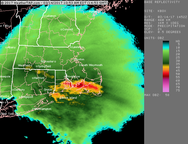
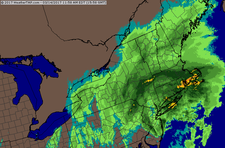
The approach of the huge March 14th nor' easter. We had over 14 inches in ORH...this storm happened too right around when we closed on our new house. We had around 11-12 inches in Holliston judging by the landscape the next day driving there. This one hit all of New England hard save maybe parts of the south coast which flipped pretty early and some extreme exposed spots on the eastern MA shore...Logan underperformed a bit. We actually managed to avoid flipping to sleet in ORH despite most models thinking we would...the snow did get a bit rimed though late in the storm when we finally dryslotted: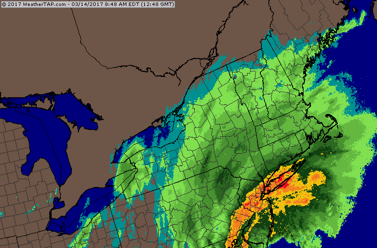
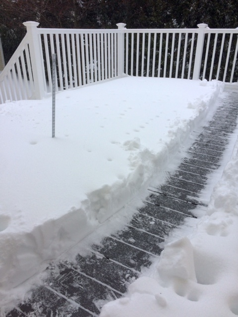
Here's the big thump on Sunday Feb 12th that gave us about 9 inches...that had followed the really nice snowstorm on February 9th...we achieved max depth after the 12th storm:
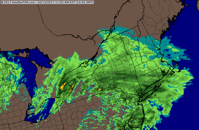
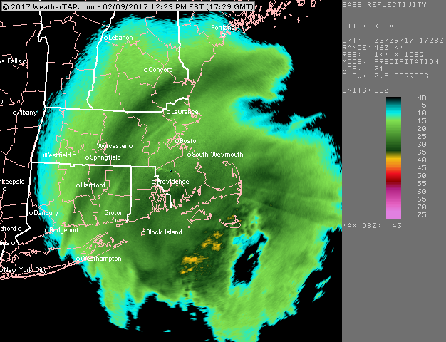
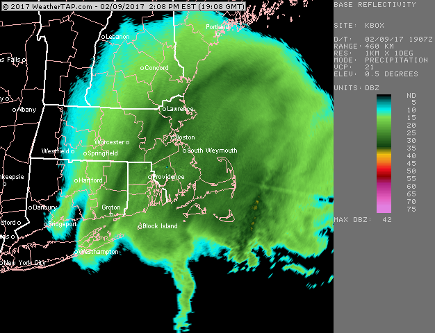
Awesome banding in the February 9th storm:
The March storm was a dynamic one. 9.5 inches of snow sleet mix for sw coastal CT.
-
Twc lowered to 6 to 10 for NYC stating RPM model.
-
21 minutes ago, Brian5671 said:
Yep another early end to winter. Seems like 2/15 has been the date of the last big snows for a few years. Big warmth in middle of the country-hard to see how we don't get warm at some point in the next week or so. Tough winter, the cold could never hit and hold. The loss of the warm blob of water in the Pacific was a big deal along withe the AO and NAO staying positive much of the winter.
At least we reached average snowfall for the winter (actually 1 more inch to average). Very impressive considering the factors.


March 13th ... west Atlantic bombogenesis type low clipping SE New England, more certain ...may be expanding inland
in New England
Posted
Could be just a waffle, but seeing the cut back on the GEFS along with the NAM development is disheartening. Not over but disheartening.