
Arnold214
-
Posts
2,187 -
Joined
-
Last visited
Content Type
Profiles
Blogs
Forums
American Weather
Media Demo
Store
Gallery
Everything posted by Arnold214
-
Active mid December with multiple event potential
Arnold214 replied to Typhoon Tip's topic in New England
Streamlines probably have some sort of smoothing factor involved. -
Active mid December with multiple event potential
Arnold214 replied to Typhoon Tip's topic in New England
Most of the HREF members are very high res. Could just be local upslope/downslope effects also. -
Active mid December with multiple event potential
Arnold214 replied to Typhoon Tip's topic in New England
Porky pig will probably remain just north of your fanny. -
Active mid December with multiple event potential
Arnold214 replied to Typhoon Tip's topic in New England
That pork pipe there near MHT on several models that it's actually showing up on the NBM. That area caught between 2 forcing mechanisms. -
Active mid December with multiple event potential
Arnold214 replied to Typhoon Tip's topic in New England
it has the 18z runs today. its bassackwords. -
Active mid December with multiple event potential
Arnold214 replied to Typhoon Tip's topic in New England
The kooch will do that. -
Active mid December with multiple event potential
Arnold214 replied to Typhoon Tip's topic in New England
That northern band is tied nicely to warm front at 600mb. Strongly sloped ascent in the mid levels is good for the soul. -
Active mid December with multiple event potential
Arnold214 replied to Typhoon Tip's topic in New England
Kootchie likes the white stuff too much in this here case. -
Active mid December with multiple event potential
Arnold214 replied to Typhoon Tip's topic in New England
Don't want to drop a sonde down someone's chimney. -
Active mid December with multiple event potential
Arnold214 replied to Typhoon Tip's topic in New England
I know wxbell and pivotal weather have it. I haven't looked elsewhere but it should be. -
Active mid December with multiple event potential
Arnold214 replied to Typhoon Tip's topic in New England
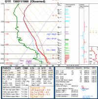
I think a few more may have been added...but the general idea.
-
Active mid December with multiple event potential
Arnold214 replied to Typhoon Tip's topic in New England
Lol, dude you are vicious. -
December 5-6, 2020 Storm Observations and Nowcast
Arnold214 replied to Baroclinic Zone's topic in New England
Yeah almost 200k out. Should put us in the top 10 as far as outages go. -
December 5-6, 2020 Storm Observations and Nowcast
Arnold214 replied to Baroclinic Zone's topic in New England
4.5” of slime. No power. -
Dec 5/6th major coastal/ west Atlantic cyclogenesis ...?
Arnold214 replied to Typhoon Tip's topic in New England
Not sure why that is. It’s possible that sv sets snow algorithm to 0 when temp is >32. With that said, wb could end up being too high in places due to weaker forcing. -
Dec 5/6th major coastal/ west Atlantic cyclogenesis ...?
Arnold214 replied to Typhoon Tip's topic in New England
A lot of interesting things are bound to happen tomorrow. Some people are going to stay rain longer than thought and some will go over to snow quicker. I’m just watching run after run of the HRRR to find continuity and so far it seems to be alright. -
Dec 5/6th major coastal/ west Atlantic cyclogenesis ...?
Arnold214 replied to Typhoon Tip's topic in New England
That only has lewiston maine getting 3”. I’d be fairly shocked if it was that low. The only way i can see that happening if we warm sectored aloft and the banding stayed to the west then dissipated. -
Dec 5/6th major coastal/ west Atlantic cyclogenesis ...?
Arnold214 replied to Typhoon Tip's topic in New England
Wow, nice. The Sugarloaf Ski area should get wrecked pretty good. -
Dec 5/6th major coastal/ west Atlantic cyclogenesis ...?
Arnold214 replied to Typhoon Tip's topic in New England
Probably melting into the floor. -
Dec 5/6th major coastal/ west Atlantic cyclogenesis ...?
Arnold214 replied to Typhoon Tip's topic in New England
Randy, Where are you set up for the storm? -
Dec 5/6th major coastal/ west Atlantic cyclogenesis ...?
Arnold214 replied to Typhoon Tip's topic in New England
I can’t believe you still have that. That was an epic thread lol. -
Dec 5/6th major coastal/ west Atlantic cyclogenesis ...?
Arnold214 replied to Typhoon Tip's topic in New England
Probably #1 for me also. Although I have special memories from several. -
Dec 5/6th major coastal/ west Atlantic cyclogenesis ...?
Arnold214 replied to Typhoon Tip's topic in New England
Yeah he lived in CT. Usually he was too busy in OT posting pics of himself flexing shirtless in front of a mirror. -
Dec 5/6th major coastal/ west Atlantic cyclogenesis ...?
Arnold214 replied to Typhoon Tip's topic in New England
I was just gonna mention that lol. I had forgotten his user name tho. He was a disaster in off-topic. -
Dec 5/6th major coastal/ west Atlantic cyclogenesis ...?
Arnold214 replied to Typhoon Tip's topic in New England
Yep, that’s him.


