Arnold214
-
Posts
2,187 -
Joined
-
Last visited
Content Type
Profiles
Blogs
Forums
American Weather
Media Demo
Store
Gallery
Everything posted by Arnold214
-
This mainly to bust Will's balls. Still, this snowstorm probably makes my top 5 list.
-
post the link to when it gets good.
-
The 15.8" I got from that was a little disappointing when I look back on it. That could have been my 20 incher. My folks got like 8-10 more than me, lol. Banding was too transient over my place.
-
I think I would have been OK with the 4" in that case. I think Ray would have tied the noose tho.
-
If I had only another 100 ft in elevation I probably would have had accum snowfall at my place.
-
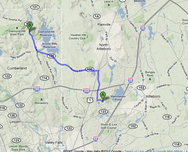
Here's the route I took that night. My house in attleboro at point A. It's 5.5 miles (or so) as a crow flies (8 miles driving). It was all snow about the time I got to the RI border if not a mile west of that on 120. Painful.
-
I was angry. I was like 5-10 miles as a crow flies from heavy snow in attleboro. Had 55-60dbz echoes overhead for 3 hours there and all it was white rain falling. Another attlehole screwjob. On my birthday no less. So, I figured I'd treat myself to a birthday present and drive the 15 minutes to see S+
-
Historic Tornado Outbreak April 27, 2011
Arnold214 replied to CUmet's topic in Weather Forecasting and Discussion
Not sure if this video was posted or not. Sorry if it was. http://mypictures.abc3340.com/MediaItemView.aspx?id=1254500 -
Historic Tornado Outbreak April 27, 2011
Arnold214 replied to CUmet's topic in Weather Forecasting and Discussion
Another debris ball...this time near Warm Springs, GA.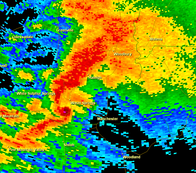
-
Historic Tornado Outbreak April 27, 2011
Arnold214 replied to CUmet's topic in Weather Forecasting and Discussion
I've never seen so many. The supercell near Dadeville, AL still has one. -
Historic Tornado Outbreak April 27, 2011
Arnold214 replied to CUmet's topic in Weather Forecasting and Discussion
I had the same exact thought. Exactly 20 years ago yesterday, too. -
Historic Tornado Outbreak April 27, 2011
Arnold214 replied to CUmet's topic in Weather Forecasting and Discussion
Very strong couplet heading toward Cave Spring, GA.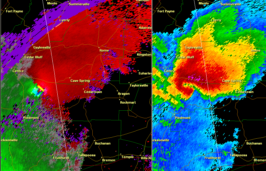
-
Historic Tornado Outbreak April 27, 2011
Arnold214 replied to CUmet's topic in Weather Forecasting and Discussion
I'm pretty sure I've never seen a more classic example of a tornadic supercell on radar than this. Maybe 5/3/99. I think I have my new avatar.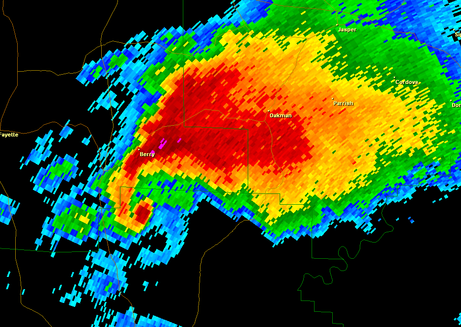
-
Historic Tornado Outbreak April 27, 2011
Arnold214 replied to CUmet's topic in Weather Forecasting and Discussion
You know it's a nasty outbreak when the current tornado warnings outnumber the svr warnings by at least double. -
Historic Tornado Outbreak April 27, 2011
Arnold214 replied to CUmet's topic in Weather Forecasting and Discussion
Yeah, that's just out of control. Big cities of Tuscaloosa and Birmingham look to be in serious trouble in the next 1-3 hours. -
Historic Tornado Outbreak April 27, 2011
Arnold214 replied to CUmet's topic in Weather Forecasting and Discussion
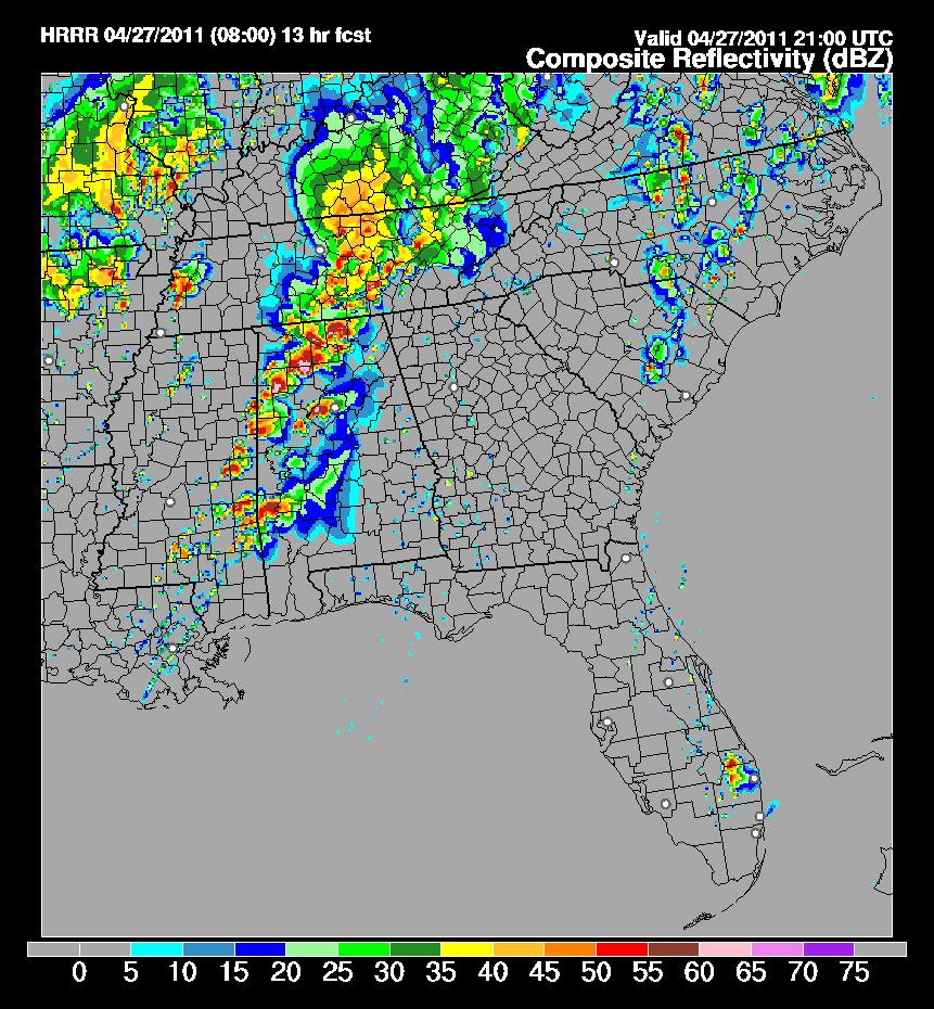
The 08z HRRR mauls much of the northern 2/3rds of the state of AL and south-central/eastern TN after 20z this afternoon. It gives ample time for the airmass to re-destabilize behind this morning's action. Here's what it's showing for CR for 21z. We'll see how it does.