CNY-LES FREAK
-
Posts
3,144 -
Joined
-
Last visited
Content Type
Profiles
Blogs
Forums
American Weather
Media Demo
Store
Gallery
Everything posted by CNY-LES FREAK
-

Upstate/Eastern New York
CNY-LES FREAK replied to BuffaloWeather's topic in Upstate New York/Pennsylvania
Bro, not for nothing, but you sir, are the culprit of all this negativity all across this forum. We all know its been an horrific winter thus far but saying the same thing over and over doesn't help anyone and as a matter of fact it probably adds fuel to an already stoked fire, but of course to each his own! -
Upstate/Eastern New York
CNY-LES FREAK replied to BuffaloWeather's topic in Upstate New York/Pennsylvania
Then WTF are u doing here? Beat it cuz -
Upstate/Eastern New York
CNY-LES FREAK replied to BuffaloWeather's topic in Upstate New York/Pennsylvania
With an aligned WNW flow, that set-up would absolutely bury CNY! -
Upstate/Eastern New York
CNY-LES FREAK replied to BuffaloWeather's topic in Upstate New York/Pennsylvania
I've been living up here for 18yrs and I've never seen no snow otg in January especially up here in Scriba, NUTS!! Sent from my SM-G970U using Tapatalk -
Upstate/Eastern New York
CNY-LES FREAK replied to BuffaloWeather's topic in Upstate New York/Pennsylvania
Terrible for you unfortunately, great for ME!!! Sent from my SM-G970U using Tapatalk -
Upstate/Eastern New York
CNY-LES FREAK replied to BuffaloWeather's topic in Upstate New York/Pennsylvania
At least! Sent from my SM-G970U using Tapatalk -
Upstate/Eastern New York
CNY-LES FREAK replied to BuffaloWeather's topic in Upstate New York/Pennsylvania
Classic -NAO map right there and if we can get that HP to migrate just a tad bit further West into WC Canada, then it would be a coupled -NAO + -EPO, with an added -AO +PNA, yowzers that would be EPIC. It would definitely bring the COLD fo sho, but that's not the issue if this in fact does come to fruition, we need moisture, and in such a cold pattern it's sometimes hard to come by. At least we have part of the equation solved, lol! Sent from my SM-G970U using Tapatalk -
Upstate/Eastern New York
CNY-LES FREAK replied to BuffaloWeather's topic in Upstate New York/Pennsylvania
They need to retune that European model I don't know what's up with it lately Sent from my SM-G970U using Tapatalk -
Upstate/Eastern New York
CNY-LES FREAK replied to BuffaloWeather's topic in Upstate New York/Pennsylvania
Yeah too bad that'll never happen Sent from my SM-G970U using Tapatalk -
Upstate/Eastern New York
CNY-LES FREAK replied to BuffaloWeather's topic in Upstate New York/Pennsylvania
Congrats to all that added to their totals!! Sent from my SM-G970U using Tapatalk -
Upstate/Eastern New York
CNY-LES FREAK replied to BuffaloWeather's topic in Upstate New York/Pennsylvania
I'd have to say if you had some elevation with this event you definitely made out because most of the low-lying areas practically got nothing Sent from my SM-G970U using Tapatalk -
Upstate/Eastern New York
CNY-LES FREAK replied to BuffaloWeather's topic in Upstate New York/Pennsylvania
For the event as a whole I think I got about an inch and an inch and a half of slop Sent from my SM-G970U using Tapatalk -
Upstate/Eastern New York
CNY-LES FREAK replied to BuffaloWeather's topic in Upstate New York/Pennsylvania
Snowing real nicely here in West Monroe as I head to work in boonville. I'm just hoping the whole ride is not snowy but the way it looks to me 29 degrees foggy snow is falling moderately and the roads are covered. I guess I will have to live vicariously through work for the next three four weeks. Sent from my SM-G970U using Tapatalk -
Upstate/Eastern New York
CNY-LES FREAK replied to BuffaloWeather's topic in Upstate New York/Pennsylvania
The whole country is practically above normal and this map shows how disgusting this Winter really is! The only pocket of cool air is over the Ohio Valley and the NE but that should be gone by tomorrow, lol! -
Upstate/Eastern New York
CNY-LES FREAK replied to BuffaloWeather's topic in Upstate New York/Pennsylvania
The LES during that period on a W-WNW flow would be absolutely EPIC but we all know its just not gonna happen unfortunately! -
Upstate/Eastern New York
CNY-LES FREAK replied to BuffaloWeather's topic in Upstate New York/Pennsylvania
I don't see any backbuilding but perhaps it can reform later this evening but I wouldn't hold my breath! -
Upstate/Eastern New York
CNY-LES FREAK replied to BuffaloWeather's topic in Upstate New York/Pennsylvania
You guys want a cross-polar flow well here you go and it doesn't go anywhere as it seems to stick around but its a ways away so we can see 50's at this time as well but id root for the latter, lol Dare I say -EPO guys as perhaps the SSW may infact start the process so we'll see! -
Upstate/Eastern New York
CNY-LES FREAK replied to BuffaloWeather's topic in Upstate New York/Pennsylvania
This is the kind of track we want for substantial snows throughout the forum, well maybe not far WNY but you guys would still get something id imagine. The SLP starts out in SEPA heads directly over NYC then heads NNE through the Conn river valley and continues to move NNE into the GOM. Thats one of my fav ttracks for this area except of course for the Hudson Valley runner that I have yet to experience, lol, and I've been here 18yrs so thats how common that track is, RLMAO! yeah its eon's away but this period bears watching! -
Upstate/Eastern New York
CNY-LES FREAK replied to BuffaloWeather's topic in Upstate New York/Pennsylvania
Wow is Buffalo that good that they just beat the crap out in of Miami 56 to 19 with still 6 minutes and 18 seconds left in the 4th quarter. I mean they're not a scrub team at 10 and 5 so if Buffalo can just run all over these guys or actually should I say run through these guys the way they did all day, Man the BIG GAME might be a lock? Sent from my SM-G970U using Tapatalk -
Upstate/Eastern New York
CNY-LES FREAK replied to BuffaloWeather's topic in Upstate New York/Pennsylvania
Thats not the least snowiest, its 32.6" in 1936 or something like that. Either way, I think we can do it, why not as it just refuses to snow anymore! -
Upstate/Eastern New York
CNY-LES FREAK replied to BuffaloWeather's topic in Upstate New York/Pennsylvania
That disturbance down in the South Central GOM moving Northward is Sundays event and i think that one needs to be watched as it can change quite rapidly from a nuisance to something trackable.
-
Upstate/Eastern New York
CNY-LES FREAK replied to BuffaloWeather's topic in Upstate New York/Pennsylvania
Yeah but when do they ever, lol, oh wait when theres a cutter forecasted then their agreement is amazing, lol! -
Upstate/Eastern New York
CNY-LES FREAK replied to BuffaloWeather's topic in Upstate New York/Pennsylvania
18Z GFS is just chock full of snow chances but not too terribly cold but definitely cold enough for snow, oh and quite a few chances for a WNW-NW wind flow regime so LE chances are looking better and better. For instance after Sundays debacle, our LE chances ramp up day after day so we'll see what happens! -
Upstate/Eastern New York
CNY-LES FREAK replied to BuffaloWeather's topic in Upstate New York/Pennsylvania
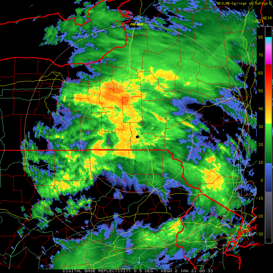
Here she comes, the good ole dry-slot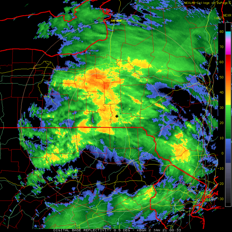

-
Upstate/Eastern New York
CNY-LES FREAK replied to BuffaloWeather's topic in Upstate New York/Pennsylvania
The critical thicknesses were above our latitude all day so expecting snow wasn't a good idea. I too expected a couple before any changeover but after I looked at them, I changed my tune as I knew it would start off as a mix unfortunately!