CNY-LES FREAK
-
Posts
3,144 -
Joined
-
Last visited
Content Type
Profiles
Blogs
Forums
American Weather
Media Demo
Store
Gallery
Everything posted by CNY-LES FREAK
-

Upstate/Eastern New York
CNY-LES FREAK replied to BuffaloWeather's topic in Upstate New York/Pennsylvania
How much rain we getting from that cutter Sent from my SM-G970U using Tapatalk -
Upstate/Eastern New York
CNY-LES FREAK replied to BuffaloWeather's topic in Upstate New York/Pennsylvania
Might of been the best 9-10 hrs of the past 5-6 winters except for 14-15 of course but it was exceptionally just a perfect set up as I will study what actually happened with this band as it just sat over me for hrs and hrs as I haven't seen it do for yrs and yrs with temps dropping as the center of the band came over head and just stalled, WOW. In the middle of the band, winds went calm almost as though u were in the center of a hurricane where,I'd imagine winds just drop off after ur affected by the inner wall, same kind of thing here happened. Then it just poured, and I mean poured [emoji3587][emoji3587][emoji3587][emoji3587] for hrs at ann avg rate of 2"/he at times flirting with 3-4"at special times as I was under yellow returns for a long time. All of the neighbors house's were gone as they all live about an 1/8 of a mile from me and the fog was thick as well, just a fantastic winter night! Sent from my SM-G970U using Tapatalk -
Upstate/Eastern New York
CNY-LES FREAK replied to BuffaloWeather's topic in Upstate New York/Pennsylvania
At, 7 this morning we had 13.6 and I just came out to do another measurement and we're at 14.8" close to 15 as e continue to snow in between showers. Sent from my SM-G970U using Tapatalk -
Upstate/Eastern New York
CNY-LES FREAK replied to BuffaloWeather's topic in Upstate New York/Pennsylvania
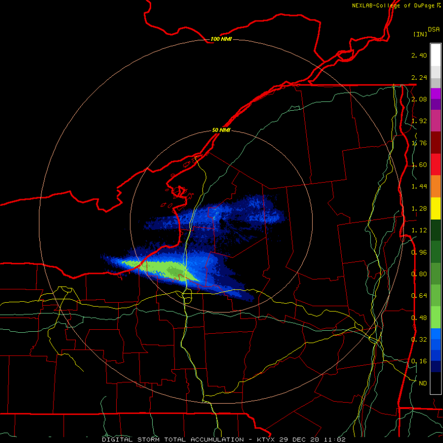
Here's a storm total in liq and you can see right overhead we're approaching .6-.9" liq eq and with ratios easily approaching 15"/1" I can see me easily reaching 15" or perhaps more but we'll see soon enough after I take a measurement!
-
Upstate/Eastern New York
CNY-LES FREAK replied to BuffaloWeather's topic in Upstate New York/Pennsylvania
Ive been up all night and for a time between 2-4 rates were easily 3-4"/hr! -
Upstate/Eastern New York
CNY-LES FREAK replied to BuffaloWeather's topic in Upstate New York/Pennsylvania
Thats my zero turn mower, oops, lol, but it's practically covered, lol! This has to be one of the best bands I've experienced in at least 10 yrs as far as intensity goes as well as longevity so congrats, finally to CNY, MAX and I as we finally cashed in big time for once! After I take a measurement at 7, I'll have to take a nap cause I've been up all night tracking this beast and it finally paid off! Max will wake and say he got 3" watch, lol! Sent from my SM-G970U using Tapatalk -
Upstate/Eastern New York
CNY-LES FREAK replied to BuffaloWeather's topic in Upstate New York/Pennsylvania
I'm nearing close to 15" we easily if not more but I'll know soon enough but from the looks of this banister it's close Id say! Sent from my SM-G970U using Tapatalk -
Upstate/Eastern New York
CNY-LES FREAK replied to BuffaloWeather's topic in Upstate New York/Pennsylvania
yeah, its usually windy on the outer edges of a band but in the center its calm! At least ur getting some action! -
Upstate/Eastern New York
CNY-LES FREAK replied to BuffaloWeather's topic in Upstate New York/Pennsylvania
TUG, u should definitely be into it now no? -
Upstate/Eastern New York
CNY-LES FREAK replied to BuffaloWeather's topic in Upstate New York/Pennsylvania
I'm well over a foot and I cant wait to take a measurement when the sun rises so I can see, lol! -
Upstate/Eastern New York
CNY-LES FREAK replied to BuffaloWeather's topic in Upstate New York/Pennsylvania
You can see the Northern extent starting to dissipate at it starts to settle to the South but either way, I'm super happy as I can now say I got something appreciable! -
Upstate/Eastern New York
CNY-LES FREAK replied to BuffaloWeather's topic in Upstate New York/Pennsylvania
Since I took that pic, it has snowed another 2-3" easy, lol, thats how hard its been falling and like I said with virtually now wind! -
Upstate/Eastern New York
CNY-LES FREAK replied to BuffaloWeather's topic in Upstate New York/Pennsylvania
Thanks George and I was thinking the same thing as you can see the band starting to take a steady jog to the South and then Matt can get in on some of the fun! -
Upstate/Eastern New York
CNY-LES FREAK replied to BuffaloWeather's topic in Upstate New York/Pennsylvania
A band of heavy snow continues over southern Oswego County early this morning, and also clipping northern Cayuga and extreme northeast Wayne counties at times. This band has been far more stationary than model guidance has suggested overnight, allowing for greater accumulations in one concentrated area of southern Oswego County. With that in mind, the advisory was upgraded to a Lake Effect Snow Warning for Oswego County. Added convergence from the approaching cold front will continue to enhance the lake band generated convergence through about 12Z, and an upstream connection to Lake Huron will also aid in intensifying the band. Snowfall rates of 2"/hr will continue through early morning under the heart of the band. Expect some minor north/south oscillation of the band through 7AM, possibly drifting a little north into central Oswego County briefly. The band will then move quickly south and west across northern Cayuga and Wayne counties by mid to late morning and weaken as boundary layer flow veers northwest behind the cold front. Meanwhile the western end of this band will continue to clip the south shore of the lake at times from eastern Niagara County to western Wayne County, including the Rochester area. This will produce minor 1-2 inch accumulations mainly along and north of Route 104 this morning. All of the lake effect snow will end this afternoon as high pressure builds into the eastern Great Lakes. As far as accumulations go, expect snow totals to reach 8-12" across southern Oswego County, and 4-7" for northern Cayuga and far northeast Wayne County, with 2-4" farther west in Wayne County and 1-2" along the lakeshore in the Rochester area. This is why models are absolutely useless when it comes to the placement, intensity and most of all the movement of these bands! -
Upstate/Eastern New York
CNY-LES FREAK replied to BuffaloWeather's topic in Upstate New York/Pennsylvania
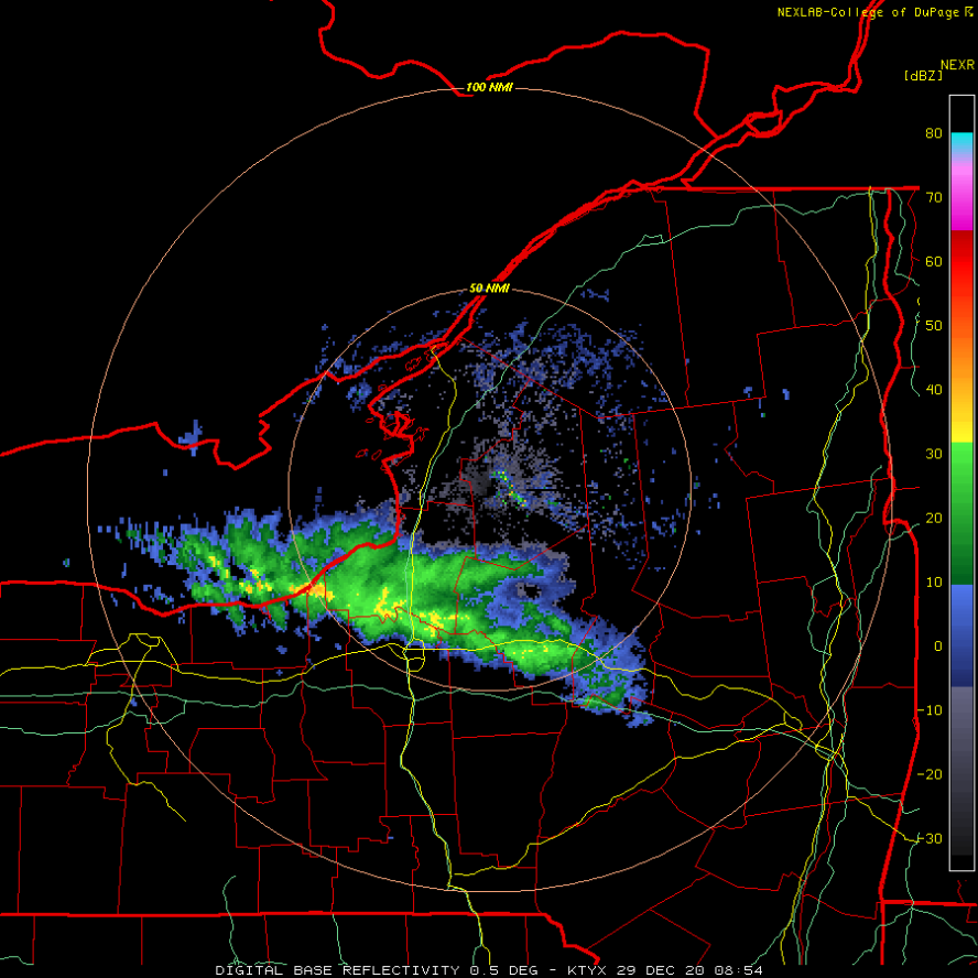
There are some reds and yellows coming my way which indicates rates approaching 3"/hr easily!
-
Upstate/Eastern New York
CNY-LES FREAK replied to BuffaloWeather's topic in Upstate New York/Pennsylvania
Wait, are you in Lysander or up by the Great Northern Mall? I thought thats where u were but if ur in Lysander then you might have to wait a bit longer! -
Upstate/Eastern New York
CNY-LES FREAK replied to BuffaloWeather's topic in Upstate New York/Pennsylvania
You can see over the Lake that its starting to take a slight jog southward so that may be the start of the move, I hope for ur sake TUG! -
Upstate/Eastern New York
CNY-LES FREAK replied to BuffaloWeather's topic in Upstate New York/Pennsylvania
Best part is, when it starts to sag Southward, it'll snow here for quite a while longer cause it looks like the lion share of the heavier returns are off to my North, [emoji38]! Sent from my SM-G970U using Tapatalk -
Upstate/Eastern New York
CNY-LES FREAK replied to BuffaloWeather's topic in Upstate New York/Pennsylvania
Here s a pic of my porch and I'm sure it's higher in some spots across my front yard! Sent from my SM-G970U using Tapatalk -
Upstate/Eastern New York
CNY-LES FREAK replied to BuffaloWeather's topic in Upstate New York/Pennsylvania
Im sure as I chased when I first moved here and drove to Mexico and went off the road and took out the Welcome to Mexico sign, lol! -
Upstate/Eastern New York
CNY-LES FREAK replied to BuffaloWeather's topic in Upstate New York/Pennsylvania
If you have AWD, I'm 4 miles to ur North if you want to u can come chill and Jebwalk all you want my friend, lol! -
Upstate/Eastern New York
CNY-LES FREAK replied to BuffaloWeather's topic in Upstate New York/Pennsylvania
Thanks as I've waited just as long as you but you will definitely get something when it starts to head South later this morning. I'm exactly 3 miles to the SW of Central Square! -
Upstate/Eastern New York
CNY-LES FREAK replied to BuffaloWeather's topic in Upstate New York/Pennsylvania
There seems to be a triple lake connection right now as well which is fueling such a strong band which usually doesn't occur on its own! -
Upstate/Eastern New York
CNY-LES FREAK replied to BuffaloWeather's topic in Upstate New York/Pennsylvania
If you ;literally drive 3-4 miles to ur North ull be in the heavy snow which makes it even more maddening, lol right! -
Upstate/Eastern New York
CNY-LES FREAK replied to BuffaloWeather's topic in Upstate New York/Pennsylvania
Nah, ur gonna see something Matt guaranteed brutha!