

caviman2201
-
Posts
1,884 -
Joined
-
Last visited
Content Type
Profiles
Blogs
Forums
American Weather
Media Demo
Store
Gallery
Posts posted by caviman2201
-
-
that mt airy cell really blew up in the last frame
-
44 minutes ago, WinterWxLuvr said:
We’ve had ensemble maps posting to the point of nausea this year but with a system approaching Monday we can’t get a single ensemble map? Friday either? Somebody kidnap Will?
Maybe folks are tired of posting snow maps that are somehow only accurate north of 70 and west of Parr's Ridge
-
 3
3
-
-
95 S&E getting a light dusting that the NW crew isn't getting in on..

-
3
-
 5
5
-
-
As per the usual arrangement, watching CHART on the Web webcams in PSU and Mappyland to see some snow in this obnoxious winter...
This let down of a storm should make those seasonal gradient maps even more painful to look at.
-
Just now, ILIKERAKE said:
dumping snow in Sparrows Point, nice surprise
You're just NE of me across the Patapsco... I'm in GB on the Marley peninsula. That band is crazy.
-
I've seen smaller ice pellets in summer thunderstorms.. the sleet is huge and pouring
-
Giant snow asteroids mixed with some of the heaviest sleet I've ever seen in Glen Burnie... crazy to watch
28/22
-
1
-
-
20 minutes ago, Bob Chill said:
Those widespread 1"+ qpf runs were suspect anyways (imo). When they first started hitting I was thinking if my yard can pull off .75 is would be fine. About right.
Ptypes on this one are nutty. Walking lines all over the area at times. 3k nam says this is sleet ptype but this sure looks like a snow sounding to me. There's a lot of that going on under the hood it seems

It doesn't help that TT uses a shade of pink/purple for heavy snow and mix lol
-
1 minute ago, Quasievil said:
Exactly. By the time it starts sleeting, we've got a comfortable snow pack. Lock it up.
I agree I'm just saying the map showing 9" is misleading... 18Z NAM was good to the whole area for sure I'd lock it up in a heartbeat.
-
So both NAMs came in snowier... maybe the start of a good last minute trend?
-
1
-
-
Just now, Quasievil said:
I'd say that's a NAM'ing.

I'd say its a lot of sleet... I hate the TT NAM maps
-
4
-
-
18Z NAM coming in snowier for the cities vs 12Z

-
3
-
-
Just now, mappy said:
This is the correct snowfall map. Yours was from 3am.
Yea i dunno what was going on with the copy/paste... in the paste window it looked fine but was reverting to the 3am map after i submitted the reply. Very weird.
-
1
-
-
LWX updated their maps...

-
4
-
-
This is the second storm this year that I've noticed has shown that 'crab claw' look that seems to have precip avoiding the cities for a while... weird

-
1
-
1
-
 1
1
-
-
This one is going to really hurt when it's puking snowballs at PSU's house and raining in the cities... again...
on the bright side, a storm starting out as nothing, getting way better right up to kickoff before getting reverse-NAM'd is the only square left on my bingo card
-
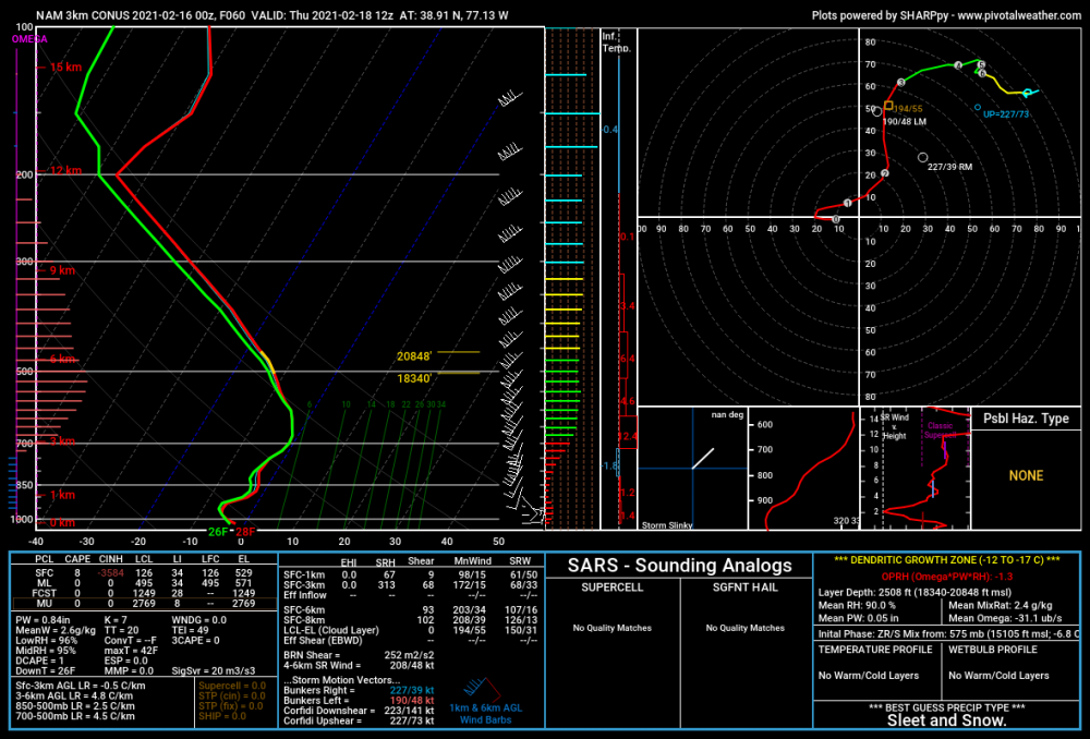
17 minutes ago, Bob Chill said:
Look at the left hand side of the sounding. The bar graph shows omega/lift at various altitudes. The denritic growth zone (DGZ) is marked in red. Super short answer is you want the biggest bars between the red lines. On this sounding car alarms are going off and visibility is -.5 miles. Yes, it's a minus sign. You can only see what happened half a mile ago cuz it's atomic puking
Thats exactly what i was going to say
-
look at the lift in the DGZ on that NAM 3k 60h sounding at DCA... that would be epic
-
1
-
-
Please let this verify...

-
1
-
-
4 minutes ago, MN Transplant said:
3k NAM. This is the sounding at DCA (top) while the sim radar looks like that (below).
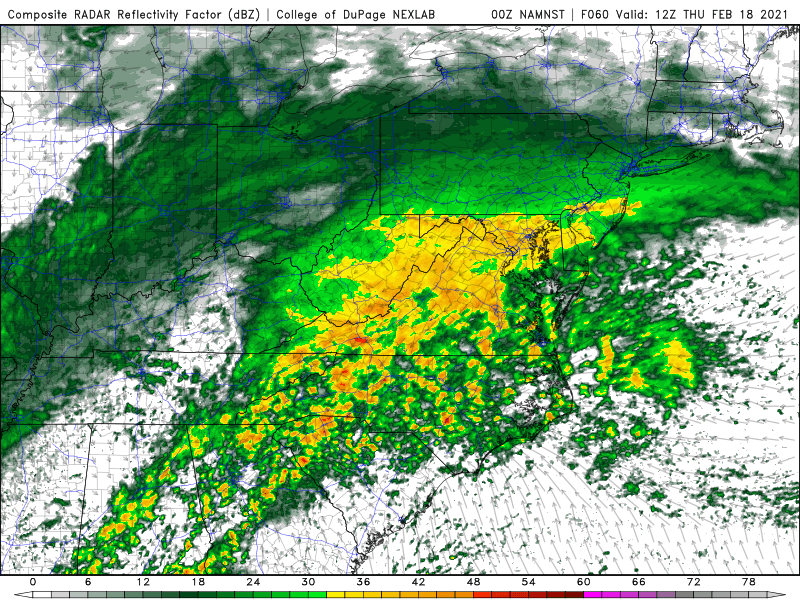
Meteors
-
 1
1
-
-
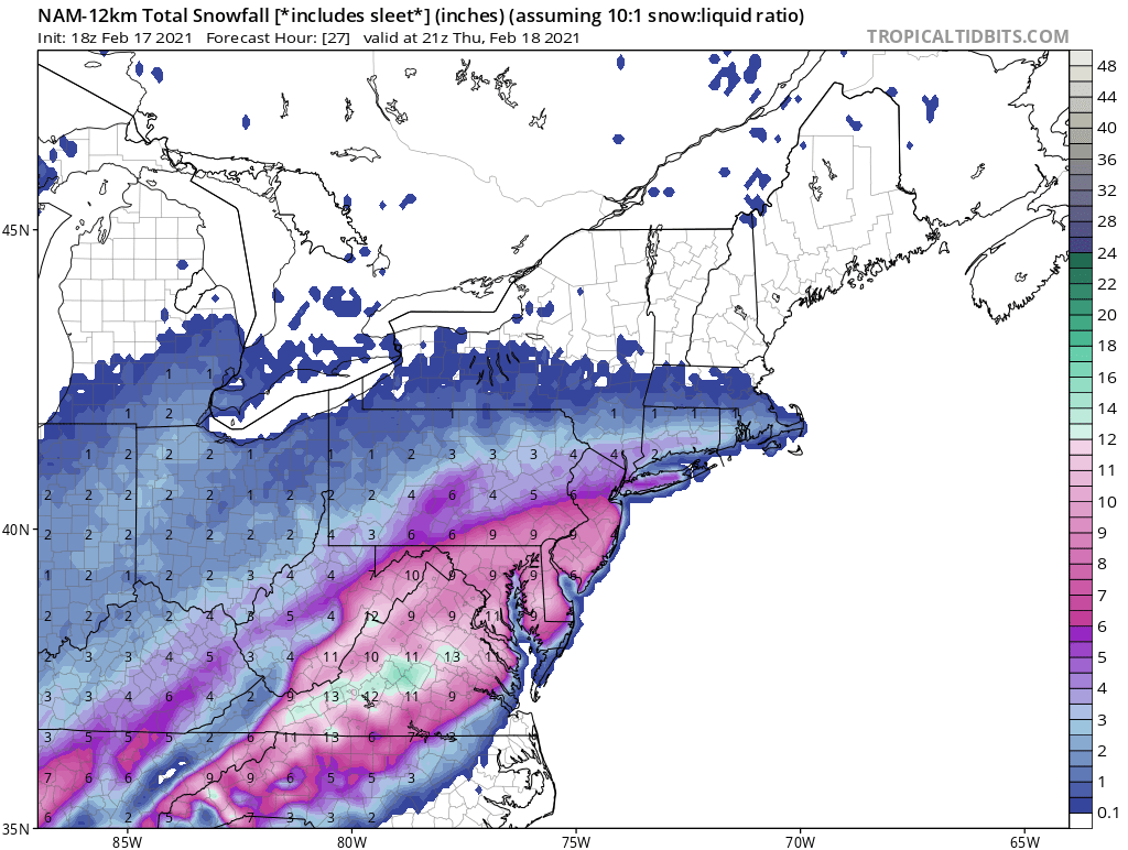
Para did the same thing as regular.. moved that heavy precip axis south compared to 12z... still a great thump area-wide
-
1
-
-
Even talking about a thread makes me nervous... the snow gods are going to think we're getting cocky
-
2
-
2
-
-
-
Para looks snowy again... DC getting the goods at 84h


2021 Mid-Atlantic Severe Weather - General Discussion
in Mid Atlantic
Posted
that seems... improbable