caviman2201
-
Posts
1,884 -
Joined
-
Last visited
Content Type
Profiles
Blogs
Forums
American Weather
Media Demo
Store
Gallery
Posts posted by caviman2201
-
-
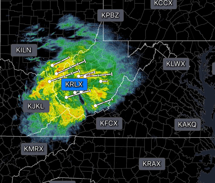
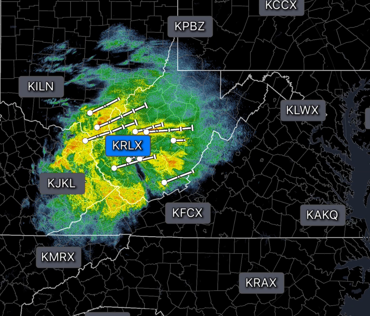
Definitely see it there. That's awesomeCheck out the CAPE Loop.
Sent from my SM-S911U using Tapatalk
-
23 minutes ago, yoda said:
https://weather.cod.edu/forecast/legacy/
Choose our region, HRRR as your model, and then time back to 12z.
You'll see a cell go into MD by DC around hour 6. Then slowly move forward to hrs 7 and 8 and you should see it
on the sim reflectivity? maybe i'm looking too hard for it... I was expecting to see it actually model the little 'ring' of outflow reflectivity like you can see in real radar scans
-
1 hour ago, MN Transplant said:
You can see on the 12z HRRR how an initial cell kicks off an outflow boundary and then new cells fire on that this afternoon. Not saying that’s exactly what will happen, but it is cool to see those processes on the models.
Had no idea even HRRR was modeling things like that... If you have a min, can you post what you're seeing? I looked and can't see it
-
Wow...
-
 1
1
-
-
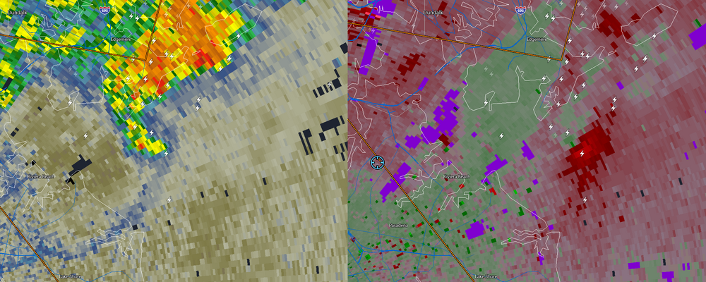
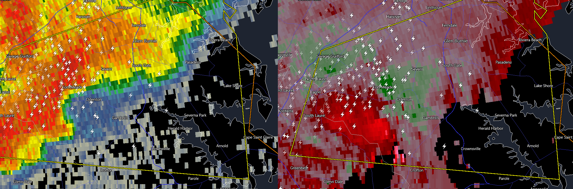
That really should be TOR warned IMO...
-
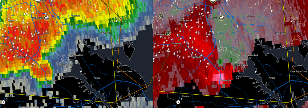
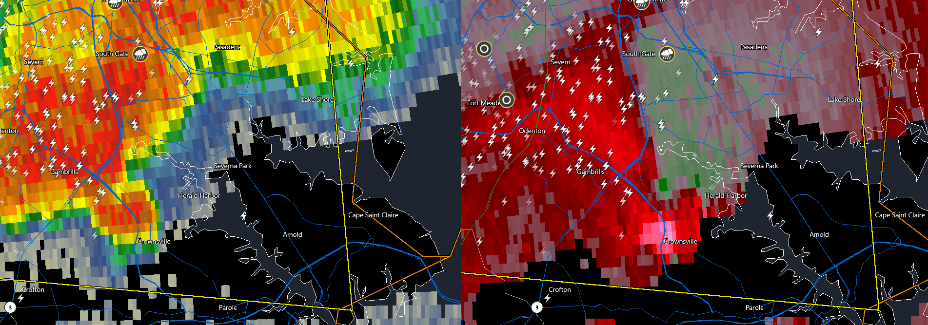
That Northern AACo storm looking kinda spicy...

-
Just now, Solution Man said:
The Icon, once again lost in space
It is coming around though...
-
3 minutes ago, DDweatherman said:
Early thoughts, fixing to make a fool of myself. Seeing hr36 on the ICON makes me think wave 1A of this will be a bit south of 12z.
ICON has been kind of on its own for days
-
1 minute ago, EB89 said:
Love that WSW cutoff right at the Frederick/Moco border

I'd be surprised if it stays that way for long
-
 1
1
-
-
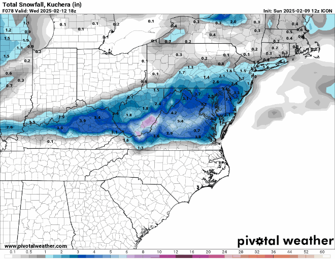
One thing thats been pretty nice this year is how the snow has been pretty evenly distributed throughout the sub. Seasonal totals from York to HGR to OKV to EZF to SBY all within 2-3" of each other and this event appears to just add to everyone's totals.
-
4 minutes ago, ravensrule said:
I fixed it dude calm down... sorry
You might want to censor it in the quote too -
1 minute ago, Terpeast said:
Just loving this board.
When models trend south, we say it’s not coming back north and bail from the storm. Then the second models shift north, we say it’s gonna go all the way to PA.
we are damaged people...
-
1
-
 6
6
-
1
-
-
We have now entered the most ************ part of this hobby... bickering over snow that hasn't even happened yet
-
3
-
3
-
-
My name is <redacted> and I am a snowaholic experiencing withdrawl...
Took the family up to Deep Creek this weekend during winter for the first time... what an experience. Got up there Thurs night and there was well over a foot on the ground. Stayed at a nice little cabin with a fireplace. It was in the teens all weekend. Friday the fam and I experienced Wisp and went tubing for the first time. Sat morning we woke up, went to a little bakery for breakfast and I sat there drinking my coffee while it poured snow with temps around 19. Driving home I got to experience first hand how magical Deep Creek/the Allegheny Front is... It snowed heavily all the way up 219 with temps in the upper teens... It was snowing heavily with temps in the teens as I drove down 68 towards Frostburg... I crested Big Savage Mountain and it began to taper off noticeably... I started to see the sun shine through the clouds... the road turned from snowy to wet... as I descended through Frostburg, the snow ended completely, the sun came out and the temp spiked to the mid-upper 20s. From Cumberland to all the way home it was sunny with wet, salty roads... with temps increasing the whole way from 19 to 36...

I thought this trip would satisfy my snow needs for a little while... especially right after our little storm on Monday... It didn't. I can't wait to go back up there as soon as possible.
-
4
-
-
Up at Deep Creek for the weekend... Around 12-15" on the ground in most places. Currently SN- and 18 at 2600ft. My first time up here in winter. Spent the day playing in the snow and tubingat Wisp with the wife and kids. Absolutely spectacular up here right now.
Sent from my SM-S911U using Tapatalk-
8
-
-
This stuff is pure pixie dust... its like its snowing glitter. Everything caved immediately
-
1
-
-
3 minutes ago, Deck Pic said:
This will be bigger than Knickerbocker. I expect to see you on mall tomorrow with a yardstick measuring 28.5"
Thats next weekend... one thing at a time
-
1
-
-
5 minutes ago, stormtracker said:
I need the youtes to simmah down. Look at this shit


-
 1
1
-
-
SN- in Glen Burnie... 31/11
-
1 minute ago, MillvilleWx said:
Hey Jeb!
I'm thinking 7-12" with up to 15" is pretty good call. 7" is for right along the bay, but even a small touch away from the bay will likely see 8+". Should be pretty! I'll be sure to get in a snow Jebwalk for you
Do you think the bay will have that much of an impact on totals given how cold its been? I noticed today driving around that most of the creeks are nearly frozen over
-
2
-
-
I find the mosaic to be highly useful in snow events... to mitigate radar "holes"
https://weather.cod.edu/satrad/?parms=subregional-Virginias-comp_radar-24-1-100-1&checked=map&colorbar=undefined-
 1
1
-
-
4 minutes ago, clskinsfan said:
JonJon about to get smashed.
The Wisp cams are the best for seeing whats going on up there... I'm shocked they still have the snowmakers on
-
2
-
-
Perhaps its been discussed already but what are the odds of some thundersnow with some of this?

-
1
-
-
This is that part of the hunt where you don't even know what to do with yourself... lol... sometimes it all just comes together nicely. We have a fantastic SNF game coming up, all schools have already closed tomorrow... kids are excited... AND, maybe something already on the horizon for next weekend.
Personally I also have the added excitement that I'm taking the fam up to Wisp on Thurs for some tubing fun... if next weekend comes to fruition and we get to come home to a blizzard... sheesh, what a week.-
1
-

2025 Severe Weather General Discussion
in Mid Atlantic
Posted
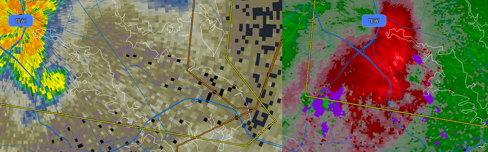
I bet this is producing a waterspout right now at the mouth of the Patapsco...