

beanskip
-
Posts
2,055 -
Joined
-
Last visited
Content Type
Profiles
Blogs
Forums
American Weather
Media Demo
Store
Gallery
Posts posted by beanskip
-
-
1 minute ago, Wow said:
No significant changes with the gfs
I know everybody is hanging on every wobble (and that's a lot of the fun of it all), but the 30,000-foot view is worth mentioning -- this is quite remarkable model consistency over the past 36 hours or more.
-
 3
3
-
-
18z GFS 500 and 850 lows actually a bit south of 12z positions at 60 hours.
-
850 temps significantly warmer at 72 hours of 12z euro. Upper features a little faster and maybe a tick south.
-
Nice little south jog vs. 0z for 12z CMC at 500 mb.
-
3
-
-
4 minutes ago, ILMRoss said:
I noticed something in the NAM suite that I thought was very promising for our general low evolution, and it's indicative of why I like to wait for the convection allowing models before I really make broad remarks on the low pressure track and how it transfers to the coast.
The low transfer is going to occur along the ribbon of low level vorticity that forms off the coast along the wedge front. It's really easy to see this on the 3km NAM at hour 60:
So, we have transfer area. Transfer portal if you will. No other model really has this depicted well. 6z GFS at 66:
12Z NAM (not hi res) which is a tough better:
Seems like a pretty small detail but it's important because if you get a sharp boundary you'll get convection/storms to form along it. Thunderstorms will take that low level vorticity and stretch it, inducing cyclogenesis and stretching that air column. How important is this feature? Elevated convection, and models not handling the ramifications well of that convection well, is how we ended up with the debacle that was Jan 2000 (I'm saying that as an example, in the year of our lord 2022 that's not happening again please dont twist my words.) Well, the 3KM NAM has some of that action at hour 60.
My entire point here is that I still think the models aren't handling the cyclogenesis along the coast well and we're still leagues away from figuring out how the transfer will work. I think there's still room for some corrections further off the coast. Or maybe this is just weenie wishcasting. There's too much football on on Sunday for my power to go out so I'm going to manifest better solutions by making long posts on weather forums.
Posts like these are why this board is so great.
-
14
-
-
6z GFS has 850 low at 90 hours over Roanoke.
12z NAM at 84 hours has it over ... Athens.
That's a pretty big spread.
-
Great trend and track for NAM but man, it's a sleetstorm for most outside of mountains until the backside comes through.
-
Man, 12z NAM got MUCH more aggressive with the CAD. Dewpoints 3-8 degrees colder from GSO down to Atlanta, vs. prior runs.
-
1
-
 1
1
-
-
Man, the CMC has the upper features moving pretty much due east from Texas/Oklahoma to Birmingham, then that sucker hangs a hard left and cuts up through western N.C. -- really screws D.C., among others.
-
 1
1
-
-
Seems like the shift in upper features didn't really translate to surface/sensible weather. Probably just model noise which will sort itself out.
-
ICON was pretty similar to past runs until 96 hours - then it really holds the 500mb low well to the south of prior runs -- Augusta instead of Asheville.
-
18z drops almost 2 inches of QPF into 2m temps in the mid-20s for the duration of the storm west of I-77. Doesn’t matter the breakdown of p-types … that’s some serious shit.
-
4
-
1
-
1
-
 3
3
-
-
11 minutes ago, rduwx said:
I know over the past 20 years of tracking storms for this area that the warm nose is always under modeled. I'm not sure the reason but there have been many times models showed all snow and I had mixing issues. Just the area we live in. I'm looking forward to a possible storm this weekend but I believe it's always best to count on mixing issues for the RDU area. Therefore you're not surprised when it happens. Not necessarily directed at you Brick. The good news is the mixing makes for some good sledding weather. Yes, 52 years young and still go sledding with the kids...LOL!
Yeah this is SOOO true. Now that I'm just an observer from afar, it helps check my "excitement bias" -- the two main biases are underestimating the "nose" and ignoring model issues with boundary layer temps. Can't tell you how many times I've been a sucker for those who say "meh, heavy precip rates will overcome those +3 BL temps" and then cursed my naivete as I watch it rain.
Having said that -- good luck, everyone, from Tallahassee. I'll be rooting hard for the BIG DOG!
-
6
-
-
5 minutes ago, KPITSnow said:
THat is a less than reliable source.
Agree. Lots of Twitter accounts tonight are claiming to be storm chaser/spotters -- but they only have a couple hundred followers and are from Indiana or someplace. May or may not be legit.
-
1
-
-
0z GFS -- east at 12 hours vs. 18z at 18 hours.
-
1
-
-
Heads up guys, I just talked with Larry Cosgrove, he says the cold air damming is waayyyyy overdone by the models. Should be a cold rain for most ....
;-) :-0
(got to be a board oldtimer to appreciate that one)
-
2
-
17
-
-
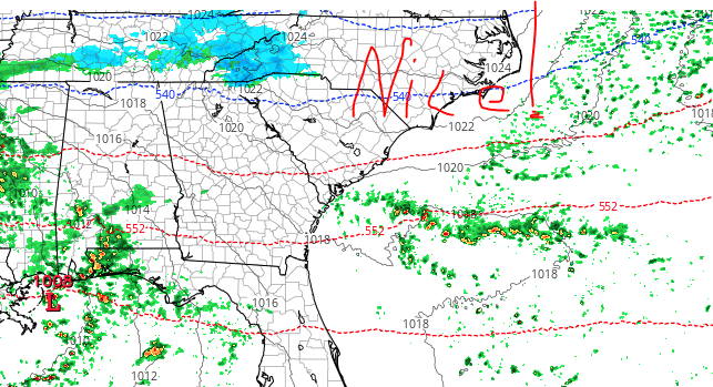
Man, 18z RGEM just plastered the mountains of NC/TN/VA.
-
1
-
-
Greetings to my SE friends -- I'll be rooting hard down here in the panhandle for every one to hit the jackpot.
I must say, though, I would exercise caution on this one for a couple of reasons:
1) this ULL is not very strong and thus will not necessarily drive high QPF rates which means ...
2) Boundary layer issues will be real -- the latest Euro run, for example, never gets it below 36 in my old stomping grounds of Shelby -- even during the highest times of precip. That's no bueno.
If I were in the mountains/northern foothills of western N.C., I'd feel good about this and with ULLs you just never really know what's going to happen in more marginal areas. But it looks very very borderline for the I-85 corridor.
That won't stop me for wishing for a Hail Mary though!
Good luck!
-
7
-
-
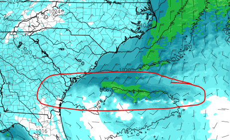
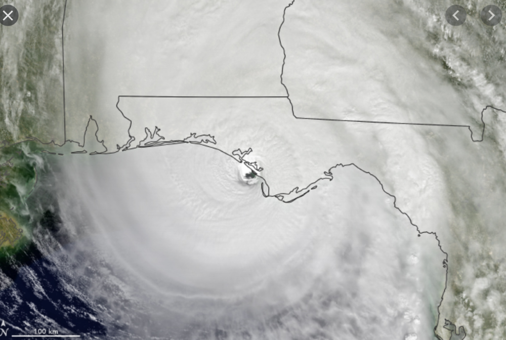
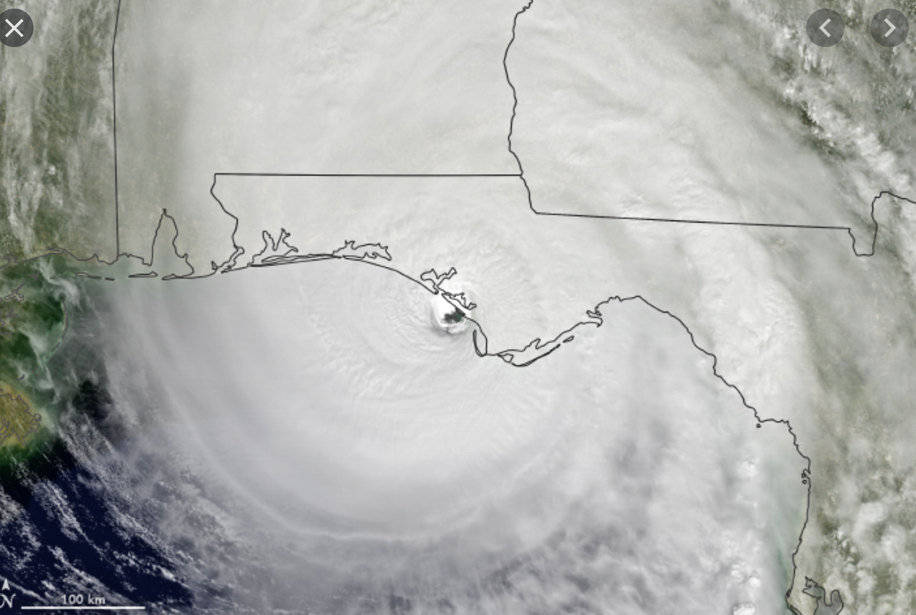
A worst-case track for New Orleans -- Zeta comes "ashore" right up Terrebonne Bay, keeping it over water for as long as possible.
-
2
-
-
Still strengthening, per latest recon pass -- yikes.
-
1
-
-
1 minute ago, jm1220 said:
Models show quite a bit of dry air entrainment and some shear in addition to the cooler waters as it comes in, so it likely peaks overnight and then starts dealing with these factors. The dry air will erode the south side pretty fast and lead to the half-a-cane. We’ll see though if this can break the pattern of many northern Gulf landfalls that go half-a-cane like Laura and Michael.
Yeah that half-a-cane Michael was really pathetic. Could barely even tell it was a storm. #facepalm
-
1
-
8
-
-
How much value can these model runs have that are initializing the surface pressure 20-40 mb too high?
-
Cold chasing precip -- a recipe for disappointment.
-
5
-
-
NHC will start "Potential Tropical Cyclone 16" advisories at 11.
Jan 15-16 Winter Storm
in Southeastern States
Posted
Yes and the 850 low on the RGEM was just about 40 miles south of the 6z position while over Georgia.
Within the model margin of error? Probably.
But I've also seen life (and death) by paper cut where 4 straight 20-40 miles shifts suddenly turned into a game-changing trend for some folks.
Worth watching when in places like my old stomping grounds, 10 miles can make all the difference with the sensible weather.