

beanskip
-
Posts
1,946 -
Joined
-
Last visited
Content Type
Profiles
Blogs
Forums
American Weather
Media Demo
Store
Gallery
Posts posted by beanskip
-
-
6 minutes ago, packfan98 said:
UGH!

That's one of the scariest maps I've seen on these boards. Greenville and Spartanburg would never been the same -- and Charlotte/Rock Hill wouldn't be much better.
-
Ok, I see now (although DPs also seem higher vs. 12z run). Will be interested to see how total QPF compares -- seems like more precip was lost in this run.
-
-
OK, so the NAM just warmed 2m temps by about 6 degrees F over the Carolinas vs. the 12z run at around 30 hours. WTF?
-
Wow, but it's so much slower that precip isn't arriving in time to take advantage of the colder temps.
-
 1
1
-
 1
1
-
-
18z NAM 850s 0c line another 25 miles SW vs. 12z run at 26 hours. Good news for I-85 corridor in SC.
-
1
-
-
12z Ukie?
-
FV3 colder ... again. Heavy snow breaking out in southern NC Piedmont at 18z Saturday.
-
 1
1
-
 1
1
-
-
Just now, PackWxMan said:
compared to RD
 U
U
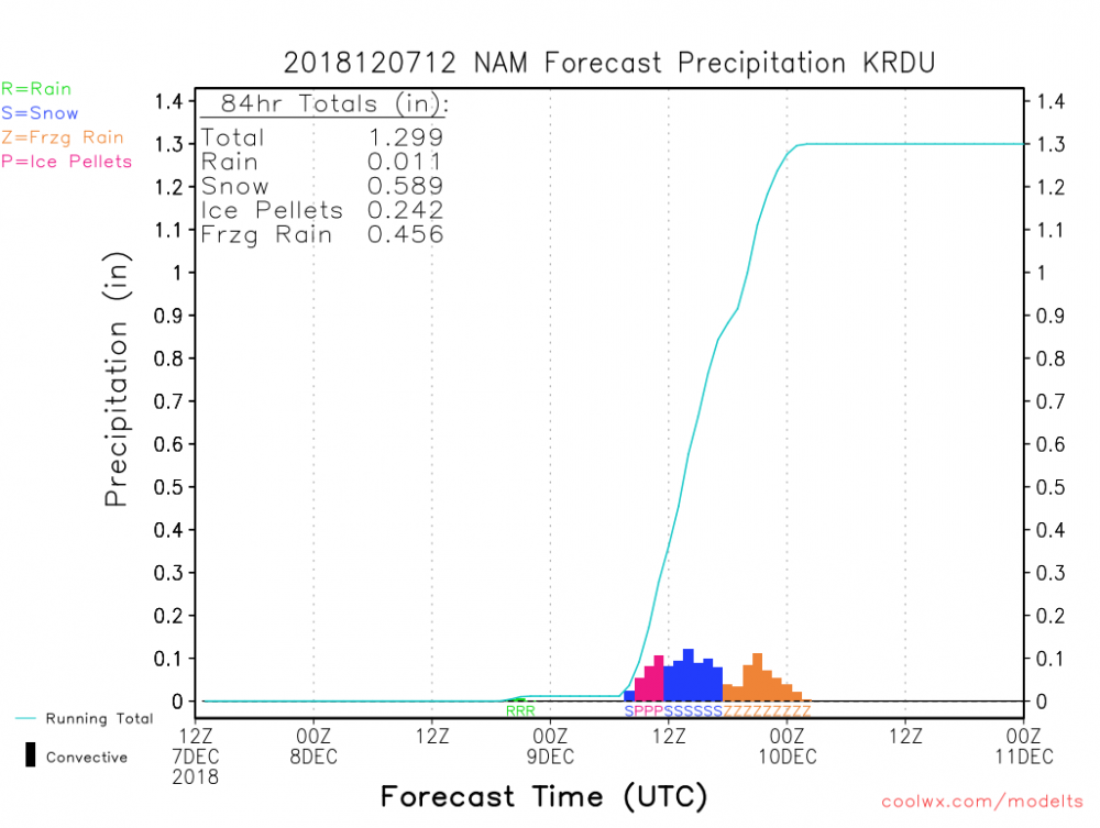
Man, that RDU sounding -- ugly ... almost a half inch of freezing rain glaze on top of 5 inches of snow on top of a layer of sleet.
-
CMC actually went back north with snow field -- would take I-85 corridor from CLT to GSP pretty much out of the game -- sleet/zra, it appears.
-
Surface low is quite a bit faster than 6z run -- was over Mobile Bay -- now all the way over to Milton, NW of Pensacola.
-
Definitely some changes vs. 6z with the orientation of the 5h disturbance. I'm not smart enough to figure out what it means, but just eyeballing, something has changed.
EDIT: 12z version seems flatter?
-
Wow -- huge surge south of 850 temps vs. 6z run -- about 50 miles south at 30 hours.
-
1
-
-
At 27 hours -- 850 temps looking nice over NC -- the 0C line has moved south a little, but the gradient is better -- that is, -5 temps have made it across the VA/NC line.
-
2
-
-
Also, nice improvement in 850 temps over NC at 21 hours vs. 6z run -- sunk down over NC/SC line on the 12z -- hadn't made it that far on prior run.
-
1
-
-
As 12z NAM gets rolling, through 15 hours, at 500mb, it's holding back the southern stream energy a bit -- and it also looks stronger.
-
1
-
1
-
-
4 minutes ago, Poimen said:
The FV-3 is another whopper for western NC. The Kuchera map is insane again. Obviously, this model may have a problem with its qpf output, as it seems to be higher than others, though the EC/GGEM aren't far behind.
Would love to see the Kuchera map. Also — is there a public site for those?
-
Very strange run. Almost like somebody jostled the map of the US and everything got shifted south. Temps looked good until the end when 850s pooped out at 72 hours. I don’t know — odd.
-
3
-
-
0z GFS basically just shifting every feature (cold air/precip/low pressure center) south throughout the run.
-
5
-
-
NAM comes back to momma.
-
1
-
-
Man, FV3 still going at 90 hours -- 12z Monday -- with snow all the way back into Georgia.
-
3
-
-
FV3 doubles down -- 850s even colder through 48 hours than the 12z run -- 0c 850 line makes it into NE Ga.
-
4
-
-
3 minutes ago, Queencitywx said:
Could definitely see this being a situation in CLT where Davidson/Mooresville see double digits, Huntersville gets 5”, an inch or two at carowinds and freezing rain once you get to Dave Lyle Blvd in RH.
Yeah, the difference between Kings Mountain and Casar in Cleveland County is going to be interesting.
-
2
-
-
7 minutes ago, wncsnow said:
Bang (not to take away from Burger)
.thumb.png.572623ac2e9a8731d208094214d0b1a8.png)
Brutal map for I-85 corridor -- not only do they take a hit on snow, but its surely replaced with ice and sleet.
.gif.3147cc27cdb0efae862d9d03899abce1.gif)

.png.4770ac4fb6be6a36e7d4058d8c068486.png)
December 8-10, 2018 Winter Storm
in Southeastern States
Posted
The hi-res NAM and the other NAMs need to huddle up and get on the same page!