

qg_omega
-
Posts
3,050 -
Joined
-
Last visited
Content Type
Profiles
Blogs
Forums
American Weather
Media Demo
Store
Gallery
Posts posted by qg_omega
-
-
12 minutes ago, bluewave said:
This was the most hostile Pacific for snowfall here in years. That big ridge north of Hawaii was something out of the most unfavorable La Nina’s. It’s a shame since we actually had pretty decent Greenland blocking in the means.

There was no real negative nao this winter despite those higher hights over Greenland
-
 1
1
-
-
43 minutes ago, SnowGoose69 said:
The always overamped RGEM at 40-54 not being too far north with the snow makes me feel the metro has a shot at this still as far as getting 2-3 inches. Even the Euro which came way north still shows around 2 in NYC
For when? Tomorrow night? No shot. It's north and mostly rain / white rain for NYC.
-
1 hour ago, LongBeachSurfFreak said:
NYC with absolutely not be raining by 7 not here on the Nw side not even close. Moderate sleet/snow continues
Most of NYC now above freezing
-
2
-
-
1 minute ago, NittanyWx said:
You busted, so did Upton. Predicting weather is hard. Learn from it.
my snow amounts were bang on, low level cold was a tad more impressive than i thought but the end result is the same. NYC will be raining by 7pm. My thoughts on mid level warmth severely reducing the snow to a 1-2 hr period was bang on.
-
 1
1
-
 4
4
-
 1
1
-
-
20 minutes ago, Stormlover74 said:
Totals so far
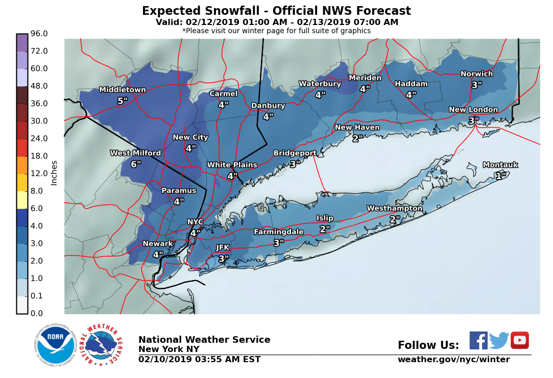
CONNECTICUT

...Fairfield County...
   Danbury                2.5   115 PM  2/12  Public
   Bethel                 2.5   130 PM  2/12  Social Media
   New Canaan             1.7   220 PM  2/12  Trained Spotter
   Bridgeport Airport     1.5   100 PM  2/12  Co-Op Observer

...New Haven County...
   North Haven            2.5   235 PM  2/12  Trained Spotter
   West Haven             2.1   130 PM  2/12  Public
   Seymour                2.0   125 PM  2/12  Trained Spotter
   Guilford               2.0   130 PM  2/12  Co-Op Observer

...New London County...
   Ledyard Center         1.5   230 PM  2/12  Trained Spotter
   New London             1.0   230 PM  2/12  CoCoRaHS

NEW JERSEY

...Bergen County...
   Ridgewood              1.3   100 PM  2/12  Trained Spotter
   Franklin Lakes         1.1   100 PM  2/12  Trained Spotter
   East Rutherford        0.5  1130 AM  2/12  Trained Spotter

...Essex County...
   Cedar Grove            1.6   130 PM  2/12  Public

...Hudson County...
   Hoboken                1.0   100 PM  2/12  Public
   Harrison               0.5   230 PM  2/12  Co-Op Observer

...Union County...
   Newark Airport         1.2   100 PM  2/12  FAA Observer

NEW YORK

...Kings County...
   1 SSW Bergen Beach     1.0  1245 PM  2/12  NYC OEM CERT

...New York County...
   Central Park           1.0   200 PM  2/12  Park Conservancy

...Orange County...
   New Windsor            2.4   130 PM  2/12  Trained Spotter
   Monroe                 2.0  1237 PM  2/12  Trained Spotter

...Queens County...
   Rego Park              1.0   130 PM  2/12  Trained Spotter
   NYC/LaGuardia Airpor   0.8   100 PM  2/12  FAA Observer
   NYC/JFK Airport        0.8   100 PM  2/12  FAA Observer

...Suffolk County...
   Mattituck              2.5   130 PM  2/12  Trained Spotter
   Ridge                  2.0   135 PM  2/12  Social Media
   Upton                  1.4   100 PM  2/12  NWS Office
   Yaphank                1.3   125 PM  2/12  Public
   Islip Airport          1.2   100 PM  2/12  FAA Observer
   Babylon                1.0  1200 PM  2/12  Social Media
   Central Islip          0.5   130 PM  2/12  Social Media

...Westchester County...
   Larchmont              1.3   150 PM  2/12  Public
1 inch for the park. .8 for the aiports, upton on twitter this morning had 3-6. Also had 5 inches at White Plains this MORNING. These totals are spot on what I predicted on Sunday. I mean its not even close.
-
1
-
-
Upton moved White Plains down to 3 inches from 5 and NYC up for 3 to 4 inches, still terrible map and way too high for NYC. NYC is quick flip to sleet from any snow, I like 1 inch of snow and maybe an inch of sleet before rain. My call has not changed. Snowgoose still like 3 or 4 easy for NYC?
-
1
-
-
4 minutes ago, HVSnowLover said:
NAM is straight out nasty especially for anyone even just north of the city, lots of sleet followed by some ZR
On 2/10/2019 at 12:31 PM, qg_omega said:Guys it's sleet to rain, stop with the snow maps. Less than an inch of snow for NYC then sleet and rain. It's a nothing burger
NAM is a nothing burger, precip is delayed and when it hits its some sleet to rain, little to no snow. My thoughts remain the same, Upton looking to bust hard once again.
-
1
-
1
-
-
Just now, powderfreak said:
I'm thinking SLK-MPV-1V4.
Now, that doesn't mean it has much of an impact that far north. I just think there will be some non-flakes up to that area...or sleet/snow mixture. Not something that will really change accumulations, but some pellets fall.
I do not think Gore or Whiteface mix with sleet for any real period of time. This looks like a good storm for them, not 20 inches like the storm in January, but still a solid 12-15. Its too bad we had all that warmth and rain in between, it was epic conditions just two weekends ago. I heard this past weekend was ok firm/fast. Base is still solid in woods, this snow should reopen everything.
-
23 hours ago, qg_omega said:
Guys it's sleet to rain, stop with the snow maps. Less than an inch of snow for NYC then sleet and rain. It's a nothing burger
23 hours ago, Snowshack said:You should let upton know, they are forecasting numbers similar to what’s being discussed here. A couple of inches in the metro actually would be notable given what’s transpired this year.
 23 hours ago, SnowGoose69 said:
This should be 3-4 inches easily. It’s possible if models are too slow advancing the precipitation in which they very well might be given they stall it for ages across EPA and NJ that this could be similar to the November storm in amounts
23 hours ago, qg_omega said:They are wrong, look at their snow map for the MLK January storm two days before, 4 to 6 inches for a large portion of the area. How much did we pick up?
23 hours ago, qg_omega said:I'll bet under on that for NYC all day. 3 to 4 easy.... Not in this setup. I'll bump this on Wednesday.
23 hours ago, SnowGoose69 said:The setup was nowhere near as good. High wasn’t a one piece anchored high. It was a sprawled our high with the neck positioned too far west across Quebec so you just didn’t get the proper CAD signature. Also the air mass wasn’t as good in place ahead of the storm
23 hours ago, weatherpruf said:I don't dismiss posters like SnowGoose. And in fact the major forecasters on 1010 and WNYC are talking similar numbers, either 1-3 or 2-4 coastal and 3-6 inland plus possible ZR there. May not be the world's biggest event, but likely to be more significant than a nothingburger, and will probably be a shock to the system for folks who have gotten complacent.
23 hours ago, SnoSki14 said:This ain't the MLK storm. The high is much stronger and better placed.
We shall see then. Also don't dismiss those just inland and away from the city.
23 hours ago, SnowGoose69 said:The MLK event high position only works when a system tracks from a low latitude. That system originated too far north in the Plains and Midwest for the CAD to properly work
22 hours ago, Ericjcrash said:I've never agreed more with an Upton product before, especially 2 days out. Excellent.
No changes to my forecast, Upton still going with 3 inches for NYC (this is down from yesterday but not nearly enough) and 5 inches for White Plains. I am in White Plains and I am expecting 1-2 inches of snow then sleet/rain.
-
1
-
-
37 minutes ago, powderfreak said:
To be honest Im not sure. Don't think it will matter much in the end but RGEM/NAM/WRF family gets it up here. EURO looked like it might get to MPV. GFS is oddly cold in mid-levels while torching low levels.
I think sleet gets up to a GFL -> RUT line , similar to Jan storm
-
Just now, SnowGoose69 said:
This should be 3-4 inches easily. It’s possible if models are too slow advancing the precipitation in which they very well might be given they stall it for ages across EPA and NJ that this could be similar to the November storm in amounts
I'll bet under on that for NYC all day. 3 to 4 easy.... Not in this setup. I'll bump this on Wednesday.
-
1
-
2
-
-
2 minutes ago, Snowshack said:
You should let upton know, they are forecasting numbers similar to what’s being discussed here. A couple of inches in the metro actually would be notable given what’s transpired this year.
They are wrong, look at their snow map for the MLK January storm two days before, 4 to 6 inches for a large portion of the area. How much did we pick up?
-
1
-
1
-
-
Guys it's sleet to rain, stop with the snow maps. Less than an inch of snow for NYC then sleet and rain. It's a nothing burger
-
1
-
1
-
1
-
-
2 minutes ago, ORH_wxman said:
These are some weird solutions being spit out for Friday. I wouldn't trust really anything right now including the cold EPS mean. Most solutions are pretty torchy right now even if they are bizarre.
It's another cutter, pretty simple as we have had them since December in this remarkablely stable winter pattern.
-
 1
1
-
-
22 minutes ago, Snow88 said:
The 2nd one isn't all rain
Any sleet will quickly go to rain
-
1
-
-
First storm is south, second is rain. It's this winter pattern in two storms
-
22 minutes ago, CoastalWx said:
Friday floods. Deep winter rolls on.
We Yore, good thing cutters ended on January 10th
-
5 hours ago, Damage In Tolland said:
He’s been wrong all winter. Why start being right now ?
Crushed my forecast from November, one of my best ever
-
20 hours ago, ORH_wxman said:
The antecedent airmass in this one is much colder than the one back in January....we actually had to advect in the cold last month during the storm. We started that one in the upper 20s and then eventually fell back as the CAD strengthened....this one is gonna be like in the teens at the start once we wetbulb.
The front end potential in this one looks a bit better too because of where the high is located...smack in the middle of Quebec is a good place for it to form the "brick wall" of cold that can create the big front end ML fronto for a thump.
Started that storm near 10 degrees and fell back to 5 degrees, this airmass is actually much warmer
-
1
-
-
50 minutes ago, SnowGoose69 said:
The GFS will never get an event like this correct ever at this range. Based on that high postition and the degree of lift that’s easily a repeat of the November event with probably 3-6 inches even to the coast
very very very unlikely, honestly no snow at all fits the pattern let alone 3-6 inches. Its a awful setup
-
Just now, purduewx80 said:
not so good for the east as a whole.
Miles better than any forecast I have seen on here or wx Twitter
-
1
-
-
3 minutes ago, purduewx80 said:
As a reminder:


Dec 1 - Feb 2 anomalies (from Maue's twitter):

not bad at all, one of the best for sure
-
1
-
-
58 minutes ago, purduewx80 said:
Just 1 operational run as an example, but last night's 00Z GFS:

That is a monster +height anomaly showing up.
meaningless, will be gone in 12 hrs.
-
1
-
-
Looks like anther rain storm cutter on Tuesday, rinse and repeat
-
1
-
1
-


Feb 18 overrunning threat
in New England
Posted
NYC will be mostly rain, snows will be well north.