

qg_omega
-
Posts
3,465 -
Joined
-
Last visited
Content Type
Profiles
Blogs
Forums
American Weather
Media Demo
Store
Gallery
Posts posted by qg_omega
-
-
Anyone have EUROWX snowfall map, that was most accurate last storm.
-
The lack of sea ice and associated -AO had a ton of momentum a few years ago, but then the sea ice remained low and the blocking went away. It doesn't mean the research is bad, could be other influences overwhelmed the pattern.
-
 2
2
-
 1
1
-
-
2 minutes ago, donsutherland1 said:
The trace was in the preliminary daily climate report, but removed from the one issued overnight.
So does this mean it officially did not occur?
-
20 hours ago, powderfreak said:
Nice to have a couple Advisory events on the Euro through Day 5-6.
I think the ski areas do well over the next 72 hours too. That’s got “the look”.
Then we have whatever the weekend does.

It’s too bad the Euro is just awful so far this year. This was gone in six hours
-
9 hours ago, donsutherland1 said:
There were flurries in parts of the area, including Central Park.
I don't see it Don:
-
 1
1
-
-
2 hours ago, donsutherland1 said:
New York City received its first snowfall of winter 2020-21 today. However, it was not measurable. Just a trace of snow was reported.
Through today, the preliminary AO average for December is -0.949. On 75% of days, the AO has been negative, including 63% when the AO has been -1.000 or below. Nevertheless, a warm anomaly has prevailed during the first eight days of December. Moreover, December remains likely to finish with a warm anomaly.
Such situations are not common. December 2001 was one such case. The AO was negative on all 31 days and at or below -1.000 on 53% of days. The AO averaged -1.276 with a minimum value of -3.293 on December 28. At New York City, the monthly mean temperature was 44.1° (then the warmest December on record, which was eclipsed in 2015) and only a trace of snow was recorded.
Tomorrow will likely remain cooler than normal. Some snow flurries and snow showers are likely. Some parts of the region could pick up a coating of snow. Afterward, milder air will move into the region. Somewhat cooler air could return to the region after next weekend.
A sustained warmer pattern could begin to develop toward the winter solstice. The closing 10 days of December could wind up generally warmer than normal. The EPS weeklies and new subseasonal guidance are in strong agreement that the last week of December will likely be warmer than normal. The latest CFSv2 weekly guidance favors much warmer than normal readings.
Historic experience following exceptionally warm November cases suggests that a warmer than normal December remains the base case. Almost 90% of cases with a November mean temperature of 51.5° or above in Central Park (2020 saw the temperature average a record 52.9° in November) went on to record a warmer than normal December and just over three-quarters of such cases saw December register a monthly mean temperature of 40.0° or above.
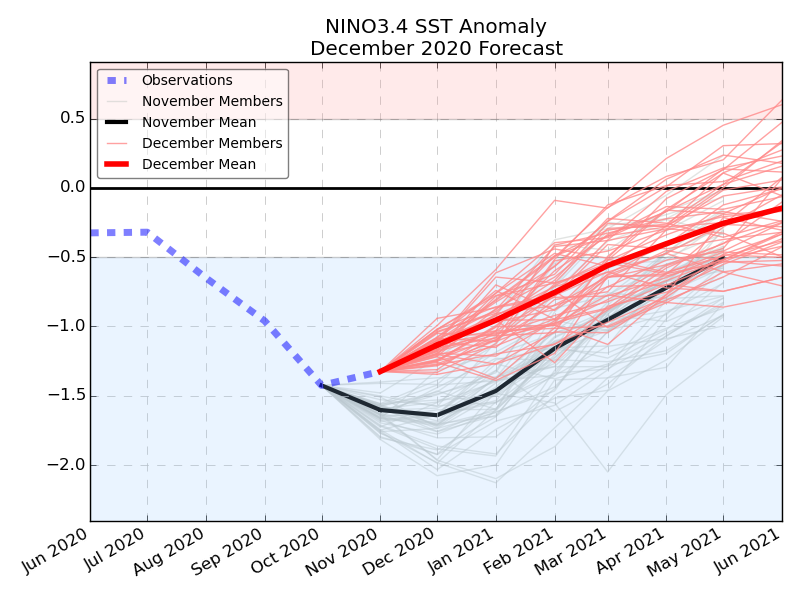
The ENSO Region 1+2 anomaly was -0.5°C and the Region 3.4 anomaly was -1.1°C for the week centered around December 2. For the past six weeks, the ENSO Region 1+2 anomaly has averaged -0.77°C and the ENSO Region 3.4 anomaly has averaged -1.35°C. La Niña conditions will likely prevail at least through the winter.
The SOI was +7.73.
Today, the preliminary Arctic Oscillation (AO) figure was -1.261.
On December 7 the MJO was in Phase 4 at an amplitude of 0.677 (RMM). The December 6-adjusted amplitude was 0.784.
Based on the latest guidance, no significant stratospheric warming event is likely through the first two weeks of December. The warming above 3 mb in response to recent strong Wave 1 activity could abate toward or just after mid-month.
Since 1950, there have been five cases where a La Niña developed during June-July-August or afterward following an El Niño winter. 4/5 (80%) of those cases saw a predominant EPO+/AO+ winter pattern. The most recent such case was 2016-17. 10/11 (91%) of the La Niña winters that followed an El Niño winter featured a predominantly positive EPO. A predominant EPO+/AO+ pattern is very likely for winter 2020-21. It is likely that the Middle Atlantic and southern New England areas will see a warmer than normal winter with below normal snowfall.
Based on sensitivity analysis applied to the latest guidance, there is an implied 73% probability that New York City will have a warmer than normal December. December will likely finish with a mean temperature near 40.0°.
There was a trace of snow today?
-
1 hour ago, jm1220 said:
Urban heat island and coastal affects already showing up this evening. Down to about 28 in my area but on the LI Sound/South shore and in NYC still in the mid to upper 30s.
Odd 31 here
-
PF, that’s crazy just checked the radar and it’s still going strong. Reminds me of finger lake effect snow, with the mountain replacing the lake
-
1
-
-
10 minutes ago, leo2000 said:
Enjoy it Met DT has posted just awhile ago on another sub forum. He showed a model directly from ecmwf which shows a dramatic weakening of the Moderate La Nina.
IN MAJOR DEVELOPMENT the ecmwf enso model shwos DRAMATIC WEAKENING of the Moderate La Nina.
It is hard to understate how BIG this is...or COULD be...
a rapidly weakening La Nina... in essence a WEAK La nina combined with SSW EVENTt
It’s just a model, wouldn’t put much stock in it. It’s very strong and there are no imminent signs of weakening
-
2
-
-
Niño is very strong, I don’t believe the weakening forecasts
-
1
-
 1
1
-
-
PIG setting up shop for the rest of the winter

-
2
-
5
-
-
1 hour ago, Allsnow said:
The GEFS were the first to back away from the better look mid month. The eps continues to show a good pattern in the 11-15 until it went towards the GEFS yesterday.
The models have been chasing this -epo/blocking pattern for a while now. In reality we just end up with more of the same. We really need something to shake things up.
We needed that massive cutter, it ended up east and weaker (the storm before yesterday’s)
-
4 minutes ago, JJBASHB said:
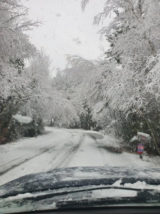
Ashburnham pic
Will be destruction there
-
1
-
-
1 minute ago, SnoSki14 said:
Except it wasn't that close. Temps were in the low 40s all night. It's not like it was mid 30s and rain.
Its 37 here right now
-
9 minutes ago, MJO812 said:
The storm last December was a big bust.
No it was a historic storm not a bust at all
-
This was really hurts enjoy the snow from NH to Maine, another very tough start to the ski year in NY
-
You can’t miss opportunities and expect a good winter, this one really hurts and likely the only opportunity until after Xmas
-
1
-
-
Can someone remove my daily post limit
-
 1
1
-
 1
1
-
1
-
-
15 minutes ago, Dan76 said:
Nah....even better
That verified lol
-
2
-
1
-
-
986mb in the perfect spot first week of December:

-
1 minute ago, jfklganyc said:
The catskills are still completely shut down. scary. I can’t wait to put on the skis
its just bad luck, if this storm was 200 miles west like the Euro was forecasting, the ski resorts in NY would be cashing in and NH and Maine would be raining, it just is what it is
-
32 minutes ago, bluewave said:
This was one of the highest daily December +PNA readings on record. It looks like it reached a +1.9. The only other years with a +1.9 that I could find were 2002 and 1989. December 2002 was a moderate El Niño and 1989 was a neutral ENSO. This would be the first for a moderate La Niña. November 2020 reached a -1.32 monthly Niño 3.4 anomaly. Both those Decembers started much colder for NYC than this year with lows under 20 during the first week. So this year is an unusually warm +PNA. This is related to the record warm November lead up to this major amplification of the ridge over Canada. There was no cold to trap underneath for us and the ridge was flatter and extended further east to the Canadian Maritimes.

its odd the EPS initialized the PNA at +4 yesterday, maybe that is why it was way too far west with the storm tomorrow and for the past few days.
-
23 minutes ago, Allsnow said:

And it’s over again, awful model
-
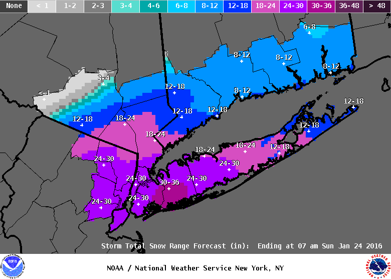
Icon and Euro are over a foot with possible blizzard conditions, GFS and NAM have sun and clouds on Sunday.
-
1
-


NNE Cold Season Thread 2020-2021
in New England
Posted
How’s the euro’s snow and ice storm for this weekend looking?