

NEOH
-
Posts
3,354 -
Joined
-
Last visited
Content Type
Profiles
Blogs
Forums
American Weather
Media Demo
Store
Gallery
Everything posted by NEOH
-
The local snow gradient is quite noticeable over short distances. The corridor from Rt.87 south to 422 seems to have the most amount of snow on the ground. Thankfully I'm sandwiched right between that area
-
The few events we've had favored areas that cash in on a NW wind direction. The Bentleyville/Solon area seems to be ground zero. Payback for all the events that have a due westerly wind we miss out on
-
Picked up just under 2" from the snow yesterday evening and overnight. Nice LES band on the west side. None of the high res models seem to have that.
-
It was RN/SN mix earlier this morning now its primarily snow. Not much accumulation with temps above freezing but the roads are slushy.
-
12z high res models are pretty snowy for the higher elevations east of the city. Wonder how long we can hang on to snow tomorrow before changing to rain.
-
Excellent AFD from OHWeather. Worth a read - https://forecast.weather.gov/product.php?site=NWS&issuedby=CLE&product=AFD&format=CI&version=1&glossary=0&highlight=off
-
Shame to be on the warm side of the low. Hopefully it continues to trend further south as we get closer. Definitely more chances for snow as we get into the weekend.
-
I use https://weather.cod.edu/satrad/nexrad/?parms=CLE-N0B-0-24-100-usa-rad
-
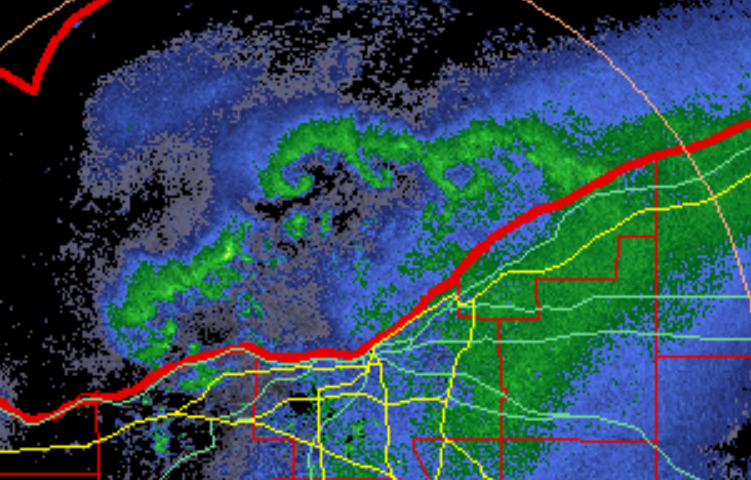
Cool to see several meso lows over the lake...
-
3"+ so far. Looks like deep winter out there. Excellent start to Winter.
-
Picked up 2.5" last night... nice surprise.
-
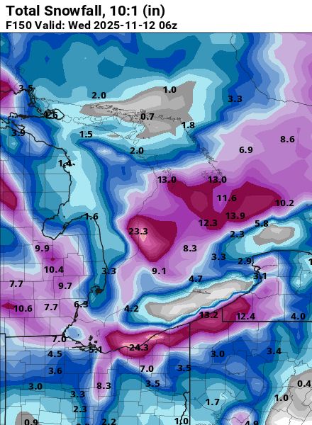
10” total so far. Looks like the hrrr was on to the southern band placement. Not sure how much more we’ll see today. The snow is very dense for lake effect.
-
Yeah the hrrr has been locked in with that band placement today. Not sure if it has a southern bias but we still have some wiggle room out this way at least. 8”+ looking likely.
-
Nice. I'll probably be sweating a little this far south in Geauga county.
-
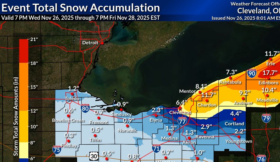
Nice to wake up to this... looking like a snowy Thanksgiving day. HZ012>014-089-251430- /O.EXB.KCLE.WS.A.0006.251127T1200Z-251129T0000Z/ Lake-Geauga-Ashtabula Inland-Ashtabula Lakeshore- Including the cities of Ashtabula, Jefferson, Willowick, South Russell, Roaming Shores, Eastlake, Middlefield, Wickliffe, Geneva, Mentor, Chardon, Bainbridge, Chesterland, Orwell, Willoughby, Conneaut, Burton, Andover, and Painesville 122 AM EST Tue Nov 25 2025 ...WINTER STORM WATCH IN EFFECT FROM THURSDAY MORNING THROUGH FRIDAY EVENING... * WHAT...Heavy lake effect snow possible. Total snow accumulations over 8 inches are possible. Winds could gust as high as 45 mph. * WHERE...Ashtabula Inland, Ashtabula Lakeshore, Geauga, and Lake Counties.
-
Nice! I didn't measure until this morning so there has definitely been a lot of compaction since yesterday.
-
Closing in on 5". Much more on elevated surfaces... although the roads were pretty bad this morning.
-
1.5" overnight. We'll see what today/tonight delivers. Nice to see the snow again.
-
Seems like the models are shifting to a more NW wind direction. Still a long way out but some of the clown maps are interesting... CMC with a 2' bullseye over downtown.
-
This is a nice spread the wealth type lake effect event. Hopefully we can get a set-up like this when its cold enough for snow.
-
It has been a rough stretch from the westside of CLE on west to your area for sure. Hopefully more rain chances to come.
-
1.47" of much needed rain yesterday. We had a good run... I'm going to miss the San Diego like weather.
-
Finally had a good drink yesterday... 1.6" of rain IMBY. Looks like CLE missed most of the rain. Not sure it is going to be a good foliage season... the colors seem muted with rapid leaf drop.
-
It definitely felt like a short Summer. August turned out quite dry around here with just 2.7" IMBY. Noticing some reds starting to show up in the maples which seems early... but has been a common theme the past few years.
-
July turned out similar to June... 8.29" of rain IMBY, with 5.18" at CLE. We had a nice dry spell during July but it didn't last long. Looks dry and comfortable for the next week or so.


