

NEOH
-
Posts
3,190 -
Joined
-
Last visited
Content Type
Profiles
Blogs
Forums
American Weather
Media Demo
Store
Gallery
Posts posted by NEOH
-
-
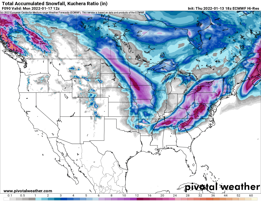
18z NAM and HRRR look pretty good for the first clipper. 3-5" across Northern Ohio. Nice to see the increase in precip.
-
 1
1
-
-
9 hours ago, OHweather said:
We got about an inch of fluff out here in Reminderville this evening on top of half an inch to an inch while I was at work. Very much feels like a Cleveland winter the last couple of weeks with a big synoptic snow plus a few LES events that have been tough to forecast but have kept us on our toes. Drove out to the Independence / Seven Hills area around 7 PM and drove through the same band that was still extending from Lake Huron down the 271 corridor into the Garfield Hts / Mayfield Hts area (and actually started snowing as far east as 91 and 422 in Solon). It was absolutely dumping near the 271/480/422 interchange. May have been 2" per hour rates. 1/8th mile visibility and just pouring dendrites. Highways were in rough shape. Got a good inch or so in the Seven Hills / Independence area of fluff in the few hours I was there, looks like what was left of that band drifted into that area.
A cold front followed by some LES and perhaps a weak clipper look on tap Saturday night through Sunday night...could be a few inches where LES occurs with a W-ish wind. Another clipper Monday or Monday night is possible (GFS still has some southern stream interaction and the timing would be more like Tuesday, but today's Canadian and Euro just have the clipper Monday evening-ish which is what I leaned towards a bit in the forecast today) followed by more cold weather and some (likely modest) lake effect with a NW flow off the icy lake through Wednesday next week.
Don't see any significant snows out of all of this but it will be cold with flakes in the air at times over the next several days.
This area was just east of the good stuff yesterday. It was interesting to watch the bands coming south off the lake then shift west and hug the 271 corridor. I had to drive up to Kirtland yesterday evening and it was dumping snow under the heavier returns. Definitely looks and feels like Winter out there. I'd image the lake will be mostly ice covered over the next couple of days.
-
1
-
-
The snow band has been hanging out around the 271 corridor for awhile now. Probably a narrow corridor that gets a few inches. Noticed that CLE put out a snowfall map for 4-6" this morning. Tough to forecast with such narrow bands. Looks like we will potentially be out the game this far east.
-
1 hour ago, dta1984 said:
Surprised to see the WWA. Looks like the Huron band is pivoting this way.
Just noticed the WWA. The Huron band is meandering back west. Looks it might be stalling out a bit in western geauga/eastern cuyahoga. Pretty much what the RGEM was showing. That model seems to have the hot hand with LES.
-
11 hours ago, OHweather said:
Not an impressive lake effect set-up, but it will be in the air later tonight and Thursday. With a light flow and fluffy snow, any Lake Huron band will drop some accumulations, but unless it stalls for a time (which could result in a fluffy few inches for a small area) it'll be light stuff.
Getting a few decent bursts of snow off of the lake. These dry arctic air masses are never good for LES. Been awhile since we've had a lake huron connection this far west so that will help. Looks like the lake huron band is currently coming through Ashtabula county and headed west.
-
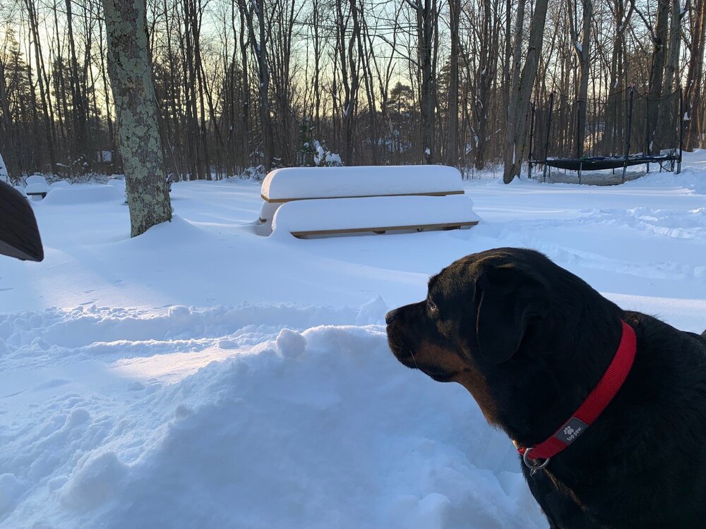
High res models are showing a lake huron band through the eastern suburbs... and even back west to CLE. Will be interesting to see if that develops. Not expecting much with the dry air though. Hopefully the clipper train can bury the picnic table.
-
4
-
-
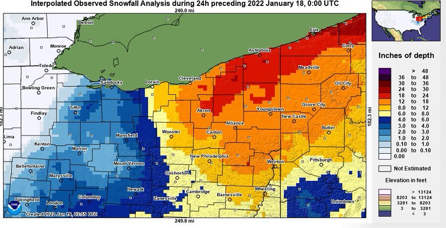
Looking at CLE's snowfall map the NAM seemed to have a good handle on snowfall totals.
-
1
-
 1
1
-
-
18 hours ago, dta1984 said:
I'm going with 17" here, average of several measurements. Decent amount of blowing and drifting now.
Storm total of 18.5" here. Picked up an additional 4.5" after 6am yesterday. The snow did compact a bit with the strong winds yesterday.
-
12 minutes ago, dta1984 said:
What a storm! We traveled home yesterday from VA so got to experience the snow down there as well.
I'll get a measurement shortly, I see there's a 19" measurement from South Russell, with most between 12-15". Still moderate snow falling.
Its still coming down nicely but definitely starting to lighten up on radar. I measured just over 14" at 6am. No idea how much has come down since then but 19" probably isn't too far off.
-
4
-
-
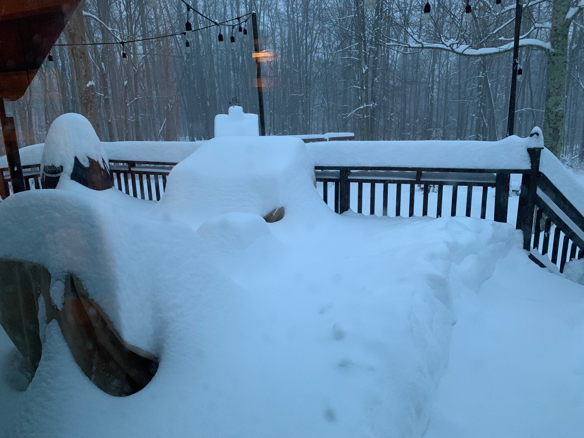
This will likely be a top 10 storm IMBY for synoptic snow. The flake size with the lake enhanced band has increased and its dumping. Drove into the office and it seems the plows have given up for the time being. Buried deck earlier this morning...

-
8
-
-
28 minutes ago, OHweather said:
Yeah there’s a silly amount of snow out there, eyeballing close to a foot. Not snowing as hard as when I went to bed but it’s still coming down. Wow.
I measured just over 14” at 6am. Looking at the radar we could push 18-20”. Awesome storm with the winds picking up.
-
2
-
-
Wow. Wasn’t expecting to wake up to this much snow. Looking at the radar loop we got smoked overnight. Eyeballing 12+ already.
-
Snow started around 5:45… couple hours earlier than expected. Snowing nicely, everything is covered and the radar looks great. Stopped looking at the models after 12z today. Going to be a nice storm for much of the area.
-
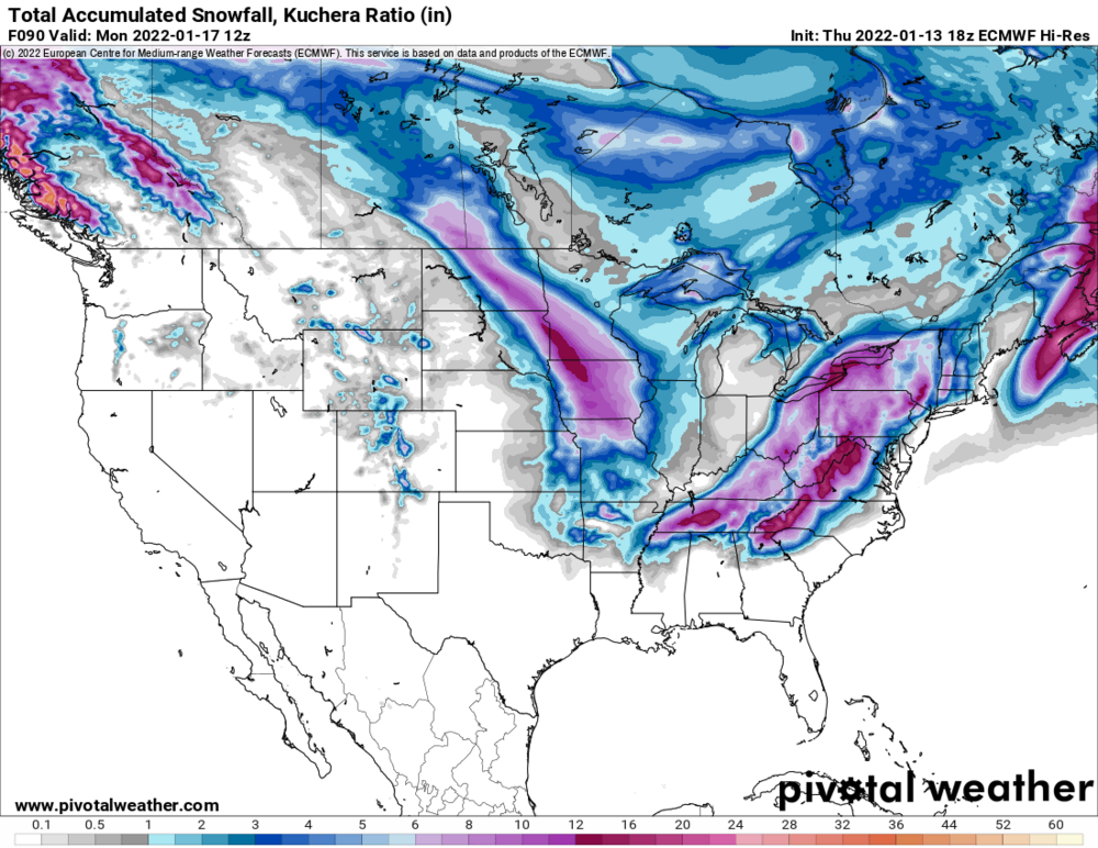
06z models with another nudge west which give a little more breathing room. Shaping up to be nice storm. Erie PA looks like the jackpot zone. We should do well in the northeast counties as well.
-
1
-
-
12 minutes ago, WHEATCENT said:
Hmm NWS only pulled trigger on WWA for lake
Just noticed that. Maybe they don’t buy the higher amounts. Today’s runs have increased a bit with most showing 8-12+ across lake and Geauga. 18z nam bumped a bit as well.
-
8 hours ago, OHweather said:
Well, models aren't shifting east or if anything, have edged west a bit. Feel like we'll probably see the watch expanded a row of counties west overnight tonight given these trends. Will be another day of interesting runs on Saturday! It'll be a sharp cut-off from warning criteria snow to just an inch or two, so small shifts can make a big difference for the Cleveland area.
Nice to see no major changes in the models. Watch out now for 8+ in Geauga county. Definitely a sharp cut off to the west. Another bump west today would certainly ease any concerns.
-
34 minutes ago, WHEATCENT said:
Another great run from Euro.
Seems like most models took a slight shift back west today... would feel a lot more comfortable with more room but all good trends today.
-
1 hour ago, WHEATCENT said:
Euro has been really consistent.

The last couple of runs have been consistent which is good to see. Hopefully it stays that way. We'll be riding a fine line either way.
-
20 minutes ago, ILSNOW said:
Nice. Thanks for posting it. Back and forth it seems with the euro.
-
Latest AFD - hopefully OHWeather didn't author this. Let's hope the northern stream is faster and stronger.
If the northern stream shortwave is a bit faster coming out of the Mississippi
Valley Saturday night and/or the associated upper trough is slightlymore
negatively tilted, then a farther west track is still possible. At this time,
brought chance PoPs for snow into southern and eastern areas Sunday afternoon
 followed by likely PoPs east of I-71 Sunday night. My gut feeling is that this
will be an advisory level snowfall, and if warning amounts are reached, they
will occur from about Youngstown to Erie, PA.
-
23 minutes ago, buckeye said:
Looks like euro went east some, but still decent for eastern half of Ohio. Biggest change I noticed was the southern vort moving much quicker and taking the turn north a little further east. Ironically still ends up over DC.
Overall pretty much everything stayed the course today. Someone said new data comes in later today? Maybe we'll start to see a swing one way or the other by tomorrow.
I believe the new sampling was incorporated in the 12z model runs. Saw that on one of the other regional discussions. If this can go negative west or along the Mississippi river you would think Central OH on east would be in good shape.
-
1 hour ago, dta1984 said:
I like where we sit to the NW side. The bleeding to the E seems to have halted. Ukie came west, and Cmc and GFS still give a good storm. We're very close to being big storm, just need a slight bump W.
Yep, feel much better on the NW side not sweating p-type issues. Sharp cut off on the NW side though so hopefully we can get a bit of a NW trend with this. Still a long way to go... A 50-75 mile shift either way makes a big difference.
-
1 hour ago, WHEATCENT said:
6z eps east as well now... i guess hope for a last ditch back west at 12z
Should have a much better idea with the 12z runs today.
-
Here's the top CIPS analog. Haven't looked at these in quite sometime but this was definitely good for Ohio - http://www.eas.slu.edu/CIPS/ANALOG/Event.php?reg=MV&fhr=F108&rundt=2022011212&dt=2012122618&HH=0&map=COSN24
Northern Ohio Obs/Discussion Part 2
in Lakes/Ohio Valley
Posted
Nice to wake up to snow falling and increased snow totals. Radar looks great.