

NEOH
-
Posts
3,279 -
Joined
-
Last visited
Content Type
Profiles
Blogs
Forums
American Weather
Media Demo
Store
Gallery
Posts posted by NEOH
-
-
14 hours ago, dta1984 said:
Ya take what we can this winter since it seems snow is hard to come by. Should be a scenic plastering with the marginal temps.
Models still look good... even increased snow totals across the the lakeshore counties. The ground will be wet, and with marginal temps there will likely be a lot of melting to start.
-
The 12z suite have a general 3-6" across northern ohio with the late week storm. Really low confidence but that would likely be the largest storm of the season.
-
29 minutes ago, OHweather said:
There were some nice bursts of borderline moderate snow last evening that quickly covered anything that wasn't paved, which was nice to see...even if the good snow lasted all of 20-30 minutes where I was! I'm getting a little more optimistic we get a crack at a better pattern for a couple of weeks around the end of Jan/beginning of Feb...but it's quite possible we don't get much of anything until then. Low odds we get a little wet snow with the low pressure going by this Friday if it tracks just right I guess, but I'm not optimistic. So, we'll see if that brief period around the end of this month can deliver. I'm sure we'll get some snow, but it's been scraps so far if you don't live up towards Erie or Buffalo (not that I'd want what Buffalo has had to go through this winter).
Good to hear the optimism toward the end of the month. The lack of lake effect in this area has been crazy. Can’t recall going this far into the season without a good event.
-
8 minutes ago, OHweather said:
Occasional dustings of snow over the last 36 hours here that have struggled to stay on the ground for long during the daylight hours...running "event total" of 0.8" with less than 0.5" (so a T) on the ground at the moment. Racking it up this season.
Nice to see the snow flying again. Temps are colder today so the grass is mostly covered. About an inch or so here. Take what we can get at this point I guess.
-
What a way to kick off January with a +18 temp departure. At least the western basin ice has probably melted
") .
.
AVERAGE MONTHLY: 48.6 TOTAL FOR MONTH: 1.55
DPTR FM NORMAL: 18.4 DPTR FM NORMAL: 1.11
HIGHEST: 62 ON 3 GRTST 24HR 0.94 ON 3- 4
LOWEST: 37 ON 4, 1
-
 2
2
-
-
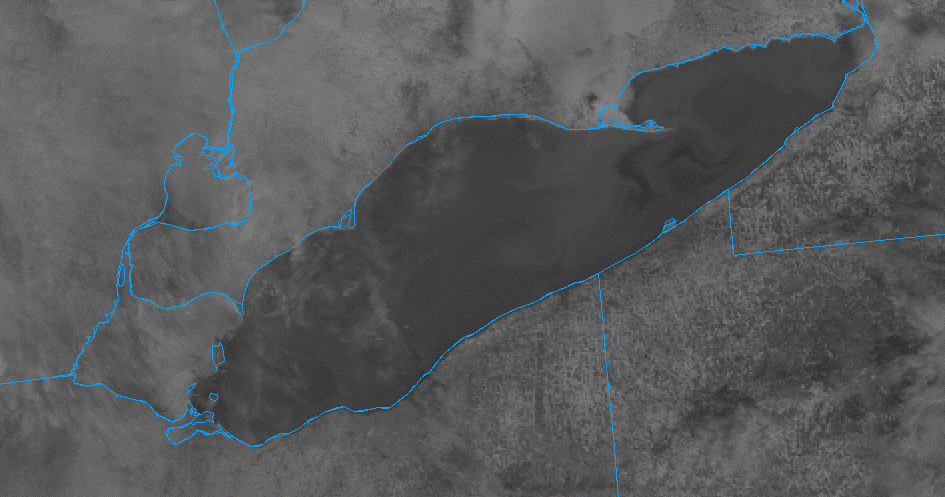
Looks like the Western basin is frozen from the Islands on west. The upcoming warmth and rain should melt most of it.
-
1 hour ago, dta1984 said:
Snow falling and snow on the ground
 . Merry Christmas all.
Merry Christmas! Perfect morning with snow falling.
-
 1
1
-
-
Buffalo had 8.8" YTD last year on 12/24... what a difference a year makes (and a favorable wind direction for lake effect).
-
5 hours ago, Floydbuster said:
Lost power for around 9 hours! Had to go down the street to my sister's house to have warmth. Nasty storm.
That sucks. Somehow we never lost power here which was nice. Just hours and hours of arctic dust and high winds. Browns game should be interesting today.
-
1 minute ago, WHEATCENT said:
1st blizzard warning in 10 years
Its pretty brutal out there. Left my house at 6am and could barely see driving. Guesstimating 3"+ of snow so far. CLE is calling for 2-4" more but not sure we will see that. You'll probably see the higher amount along the lakeshore.
-
1
-
-
Down to 20 degrees already with heavy snow. Winds are ripping as well.
-
4 minutes ago, buckeye said:
My sister and brother-in-law built a new house east of lakewood, OH. The back of their house is about 70' from the shoreline of lake erie.
Needless to say the house will be tested tomorrow
They must be in the Edgewater community. Hopefully they have a strong/large breakwall.
-
8 hours ago, MJO812 said:
Is this unusual for Buffalo ?
What lake takes long to freeze over during the winter ?
Erie freezes the quickest. There will likely be a quick freeze on the western basin this weekend.
-
1 hour ago, WHEATCENT said:
Nws is seeing 12-15 but uh....well ill hope

I really don't know what to expect snowfall wise. Seems the models have bumped upwards. CLE has 6-8" throughout Geauga county. Some of the clown maps are much higher. You should do well up by the lakeshore. .. the winds will certainly be ripping. Just hoping not to lose power out this way.
-
1
-
-
1 hour ago, dta1984 said:
Same here. Interested to see when more short range models get into better range. The fv3 looks interesting, but it's only one model.
Euro attempts to throw us a bone. A low east of Lake Ontario is usually a good spot. But everything is elongated from west to east which keeps the winds southwesterly on the backside. Probably very little chance of the orientation changing.
-
Really have no idea what to expect from this storm. A couple of inches of snow with extremely windy conditions isn't all that interesting. Hoping for a more eastward trajectory as the storm exits to maintain a flow off of the lake for as long as possible before winds turn southwesterly.
-
9 minutes ago, MJO812 said:
Syracuse area?
They have been getting screwed by lake effect recently .
I'm in the Northeast Ohio snowbelt. It has been a "lake plain" year from Ohio through WNY with the west/southwest wind direction.
-
1
-
-
1 hour ago, BuffaloWeather said:
Will be posting a ton on Twitter and YouTube.
What a season in your area. Congrats. We're on the sidelines again for this event.
-
1
-
-
2 minutes ago, Floydbuster said:
What's the trend for NE Ohio? Less snow? More snow? If those winds are gusting as strong as they say, the wind chills are going to be brutal.
Ha. Who knows at this point. What a tough storm to forecast. Sounds like the models will have full sampling later today. Hopefully the eastern trends continue. I think the trajectory of the low as it passes by will have a big impact on lake enhancement snowfall behind the low.
-
38 minutes ago, OHweather said:
I'm setting my local expectations to rain changing to a couple-few inches of wrap-around snow, with 50-60mph wind gusts and a dramatic temperature drop. I feel like that's a safe floor and is still quite a storm, though with fairly modest snow amounts. There's some potential it trends a bit less wrapped-up and east which could up the snowfall some, but given current depictions I would keep snowfall expectations somewhat in check unless we start seeing a solid east trend. My guess is the lake effect quickly becomes a southwest NY thing, as with a very deep low just to our NNE I feel winds would quickly go rather southwesterly as it pulls away.
Hey, I was hoping for better news from you
! What a LES season for WNY... really couldn't draw it up and better for that area this year. Its going to be a little frustrating when we will finally get a favorable set-up and a NW wind direction when the lake has ice.
-
15 minutes ago, dta1984 said:
Lol let's hope not.
Seems 12z runs bringing things a bit back east. Let's hope the trend continues with more sampling.
Going to be windy, that's for sure!
The CMC was a small step in the right direction. A tightly wound low due North would not be good. We need the low to move more easterly to bring the winds around to a more favorable direction.
-
21 minutes ago, Crowbar said:
Forgive my ignorance, but this means an Apps runner? Even I know that means heavy snow here.
The solution he was forecasting is likely not even close to being correct...
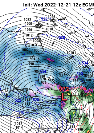
That would be the 18z GFS series, which develops a surface low pressure over the Carolinas and takes the impulse straight north into the QC Eastern Townships, then into the Laurentian Shield.
As you can tell by the packed isobar configuration on all of the mapped depictions, high winds and piercing chill factors are a given in association with this storm. The freezing air at one point may reach central Mexico. But rain and snow boundaries, and intensities, are not as easy to outline. Because of the lack of surety in the trajectory, even parts of the Mid-Atlantic and New England could see substantial snow. Accumulations of snowfall, along with icing, could reach farther south due to the broad upper low and mesoscale impulses rotating around the core. The 954MB pressure forecast on Saturday morning in QC is probably correct; this system has the word "bombogenesis" written all over it! -
19 minutes ago, dilly84 said:
Well let's hope he's right.
Long shot unfortunately. If today's 12z runs stay well west we are likely done.
-
Tough model trends for those of us in Ohio. Everyone's favorite met LC thinks this goes south and east...

There are two influencing factors that most of the numerical forecast models are missing. That would be the strong Baffin Island ridging and the energy-laden subtropical jet stream. The lower latitude feature is a boundary that a developing low pressure could realign with. And the Rex signature that is drifting westward from the mouth of the Davis Strait blocks the "into Quebec" route that predictive guidance is suggesting. Plain and simple, it makes sense to go with the scheme that shows a farther south and east track.
Northern Ohio Obs/Discussion Part 2
in Lakes/Ohio Valley
Posted
Just noticed the snowfall map... they must have let OHWeather create it