
WxMan1
-
Posts
746 -
Joined
-
Last visited
Content Type
Profiles
Blogs
Forums
American Weather
Media Demo
Store
Gallery
Posts posted by WxMan1
-
-
29 minutes ago, clskinsfan said:
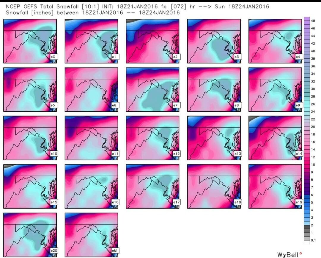
Ya'll remember Will and the rest of those guys from the NE forum coming into our thread and being amazed by what we were about to experience in 2016? They are about to get their 2016 up there.
It's like a Cowboys fan (like me) recalling the glory days, now over a quarter century ago. Thankfully we don't have to wait that long for a historic, at least Top 10 snowfall around these parts.
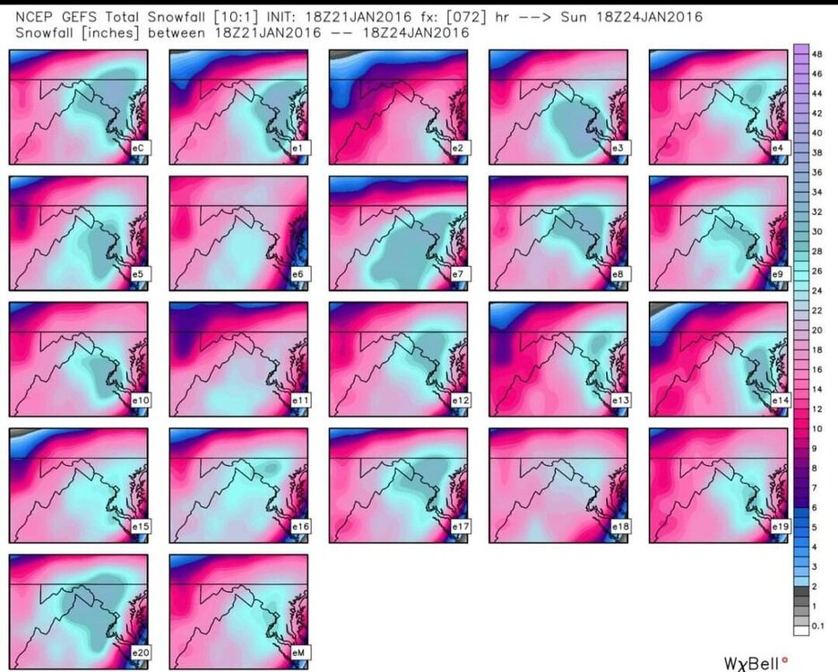
Reminisce with these GEFS panels just before the 1/22-23 event 6 years ago. Every member had at least a foot for DCA. We'll get there again someday, and it will be oh-so-sweet when it happens!
-
 17
17
-
 1
1
-
-
9 minutes ago, stormtracker said:
I know we don't want to hear about Boston, and I swear this is the first and only time Im going to mention it...but NAM is about to have a closed low and they are going to be annihilated.
They're already on it...wowzers...their storm thread is over 300 pages now. I already know 2 folks flying out of BWI tomorrow to go chase.
-
Op GFS reminding us that the in-situ dry slot can be a real deal with a transfer/low deepening offshore. What's more, I think we're all wary of several hours of pixie dust snow/lack of dendritic growth and light rates when it actually does snow.
I have no idea what the 'bar' for this storm is yet. 2-4" for the Beltway region? Sure, let's start there..-
5
-
-
Nice lift in the dendritic growth zone at FH084 around DCA.
.png.484ff7c5e188383951c159e052fc040c.png)
-
12
-
 1
1
-
-
1 minute ago, snowfan said:

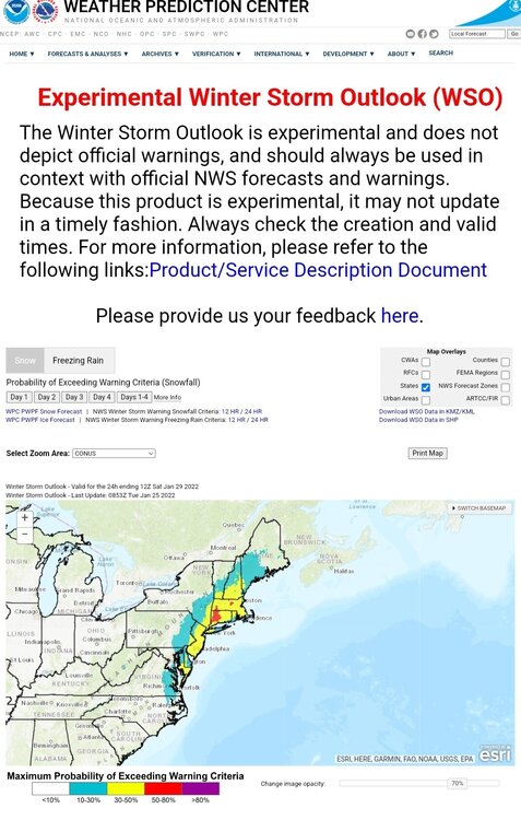
I had a heck of a time getting the cities to match up with the graphic. Thankfully the shift before last night got the key messages started. Notice how the probs went up, especially in New England.
We also now see the storm in the day 4 WSO! Let's hope the probs keep going up for us!!
-
6
-
 1
1
-
-
Just now, MillvilleWx said:
06z Euro would have been a nice spot for the sub-forum. Solid snow probably I-95 on east with Advisory level stuff to the west, easy. @CAPE @Lowershoresadness @frd and anyone on the coast would have a great time if that run kept going.
That would be a second time this winter for us easterners. I had 10.25" with the Jan 3rd system here in Crofton.
-
6
-
-
Hello all!
I figured this forum (banter) would be as good as any to put this in. Many have been talking about Miller A vs B. A few years back we did a review of the Miller Cyclone classification system -- based off of James E. Miller's research that was published in the Journal of Meteorology (June 1946). We also applied the classification to some more recent examples (and by recent, I mean the past 10-15 years). As many of you noted, there are many "hybrid" A/B types, but even in those situations, the characteristics are going to be either A or B dominant.
Not the gospel on the subject by any means, but I thought perhaps it would provide a little more clarity to the topic.
Or not.

Miller_Cyclogenesis_Classification_US_Atlantic_Coastal_Region.pdf
-
3
-
4
-
-
GFS is pretty bullish with the snow *fall*, but this could be one of those instances (ground sfc temps initially) where the actual snow is closer to the pos snow depth change map, or something between the two..
.thumb.png.01fa9ecb6a8b0298c7376f7354ab9721.png)
.thumb.png.63fdf5d7a29ab341ef8733e73dcae59f.png)
-
3
-
-
22 minutes ago, Yeoman said:
NGM and AVN, baby! I'm a half century this year, as well.. hard to believe
AVN's claim to fame: It NAILED the March 12-13 1993 Superstorm/Storm of the Century at least 5 days prior. It was very well forecasted, much like the Jan 22 2016 was once we got within 120 hours.
-
2
-
-
23 minutes ago, nw baltimore wx said:
God. The ETA.
I hear ya. Gonna be 52. DiFax charts with the ETA, but before that, the NGM, AVN, MRF, and (*cough*) LFM.
Baratropic model was a little before my time (Thank God).-
1
-
 1
1
-
-
Yes, we definitely cannot sleep on that potential next Fri-Sat, 28-29th.
-
5
-
-
1 hour ago, jlh said:
Reminds me a bit of Jan 2017.
There was also the Boxing Day snow on Dec 26, 2004. Same day as the big Tsunami in Indonesia. I was working at the Wakefield NWS at the time. 8" in Norfolk, 13" in Newport News, and 3.1" at the Wakefield NWS. Back at my house in Chester -- less than an inch. Wild storm.
-
1
-
-
49 minutes ago, HighStakes said:
One of the driest, fluffy and lightest snow I've ever shoveled.
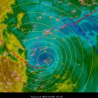
3 minutes ago, Steve25 said:Great stuff! What website is this by chance?
If off of the WPC's interactive surface analysis website...
https://origin.wpc.ncep.noaa.gov/html/sfc-zoom.php
You can also use this one to overlay satellite imagery (data quality of course dependent on how far back you go)...just click the 'archive' tab in the upper right to get to the event you're looking for, and the tab on the upper left to choose what kind of satellite imagery you want to overlay..-
1
-
6
-
-
42 minutes ago, HighStakes said:
One of the driest, fluffy and lightest snow I've ever shoveled.
It was also during Super Bowl 25, I believe the Giants vs. the Broncos. I believe the forecast for my area (West Springfield at the time) was 6-10", and we ended up getting around a foot. Fluffy stuff. At one point, DCA was getting several hours of mod-heavy snow with temps in the upper teens.
.thumb.png.1e12fe58ce1ddce5e6af875a4a80ebb4.png)
-
9
-
1
-
-
5 minutes ago, WinterWxLuvr said:
Yeah the Kuchera might be playing a role
Yeah, it certainly looks like a cold system at low levels (surface temps in the 20s), but as we know, what do the thermals aloft look like, and in particular, the lift in the DGZ? Waaay to early to quibble over those details -- the 850/700/500/250mb setup looks terrific, as does the surface low track. Reminds me a little of the Jan 26 1987 system (2nd one)...the cold Miller A that isn't overly explosive going up the coast. At least for now..
-
12
-
-
Irony...
There were people that couldn't believe we'd have snow and temps falling into the 20s during the day on Monday, Jan 3, with highs in the 60s the previous day.
And yet here we are today, temps in the mid 20s, dewpoints 0 to -6F, and yet we could be looking at plain rain in a little over 24 hours.
Just goes to show how it all comes down to the storm track (dictated by upper levels) and where the winds are blowing in from.
-
8
-
-
9 minutes ago, MillvilleWx said:
I want to make sure anyone interested in meteorology and wants to follow along with storms now and of the future; the upper level evolution is the driver the atmosphere. What happens up top will reflect what happens below it. Once you understand the dynamics of the levels 700mb and up, you can be a better forecaster. Cold and warm air will always have the ability to be washed out by an evolving surface and low-mid level pattern. This storm is no different.
Sampling is a smaller issue at range than it ever has been due to GOES 16/17 and the countless reconnaissance we have delivered over the course of the past 10-15 years. Yes, some minor shifts that could play major components to a pattern evo can occur when a specific feature is sampled over land, but the discourse of, "Changing to tunes of 100s of miles" is ancient history. Overall, this has been a pretty well documented storm with minor adjustments here and there, but in a setup where every 10 miles counts and timing is everything, they are magnified.
I didn't post last night for two reasons:
1) I was tired and my wife was finally off. I wanted to spend some time with her and we watched some of our favorite shows. It was a wonderful evening.
2) I wanted to see if models held serve on what the hi-res guidance has been insinuating recently, and it looks like they are. This will lead to a forecast shift myself, which I'll have today.
For those interested in meteorology, I will preface by saying this will be a sight to watch unfold. Result you are looking for may be damned, but take it from someone only getting more wind and absolutely no precip from 2000 miles away; enjoy the meteorology and learn, or I would find something to do on Sunday evening that will take your mind off it all. Ice will be coming, and there's nothing we can do to stop it. Pattern is still loaded in the long range. We are okay for now.
Enjoy your Saturday!! Life is too short to worry about what Mother Nature is gonna do.
"We'll weather the weather, whatever the weather, whether we like it or not!"

Absolutely spot on! While not the result we all want, it's such an anomalous track, which in of itself it pretty cool.
My neighbors now have discovered a new way of figuring out whether or not we're going to get a big winter storm. Since the pandemic, we've had the capability of working forecast ops from home. It's a great option too when the roads are awful. So my neighbors wait to see if I'm going to work (College Park). If the meteorologist leaves his house to go to work, they know we're not getting much. I told them all yesterday I'll be driving to work, lol.
-
5
-
4
-
-
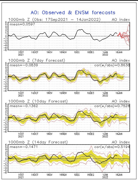
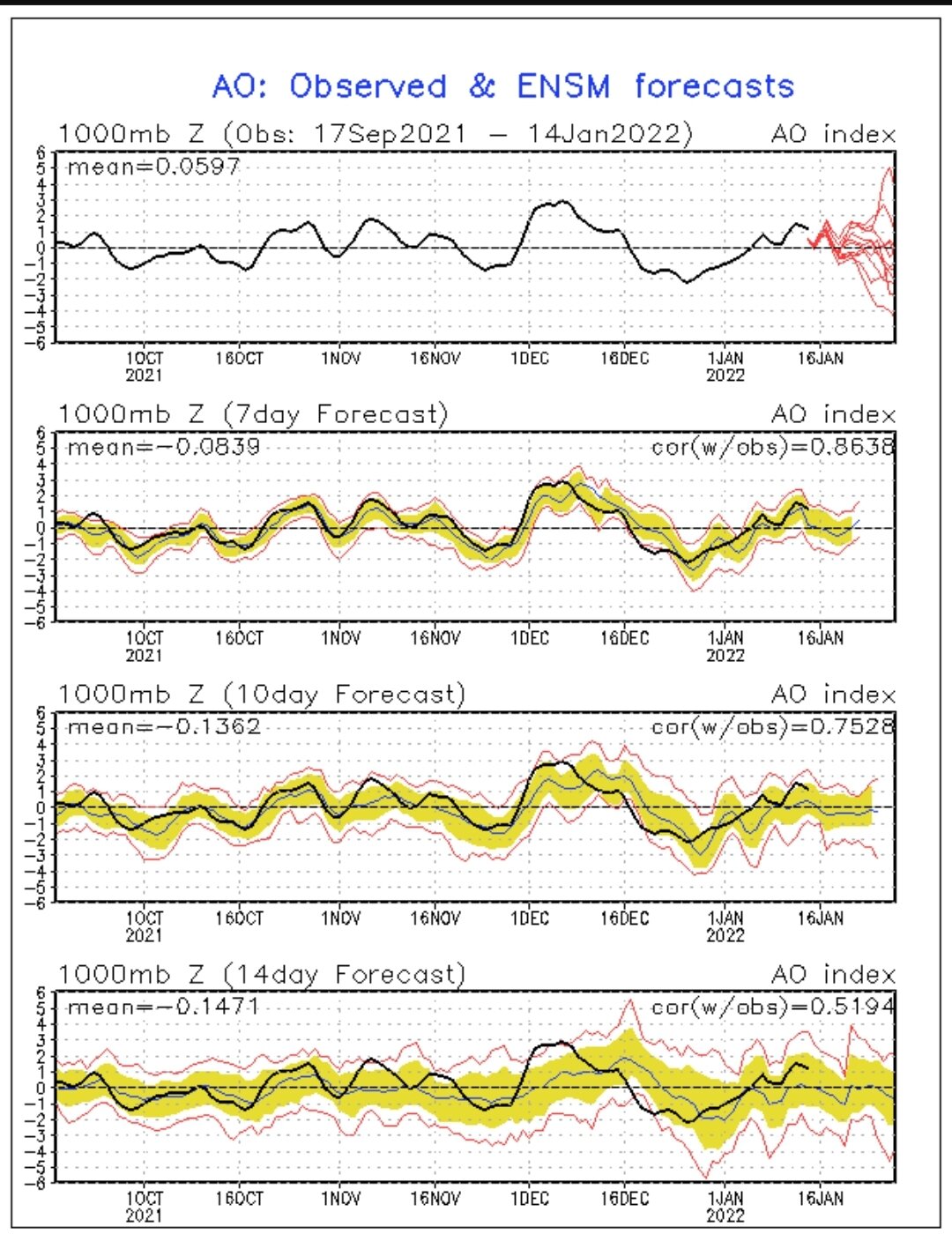
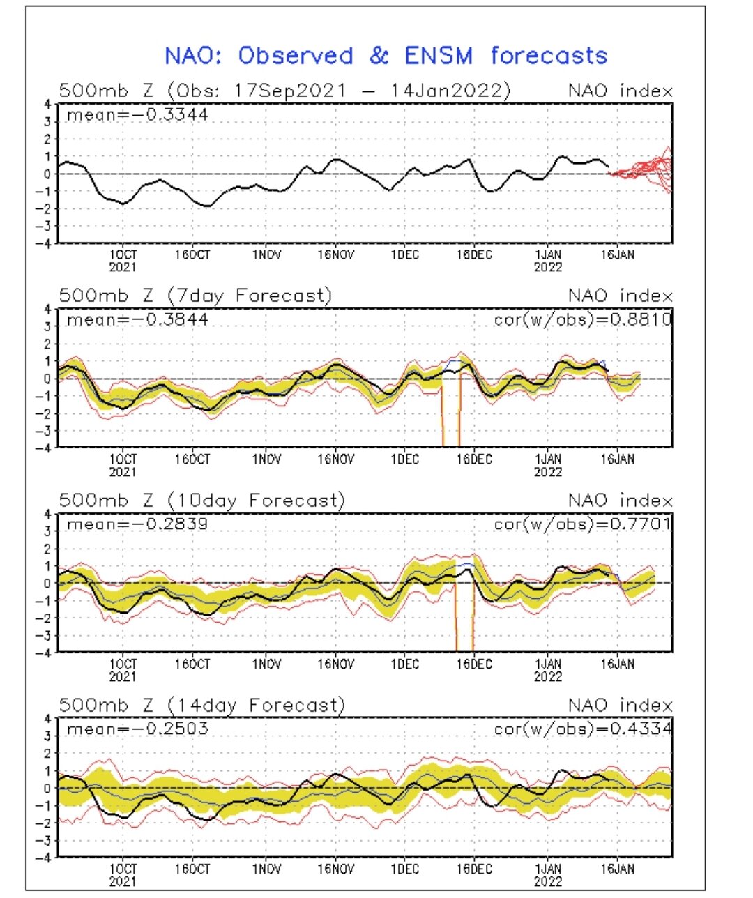
9 minutes ago, StormchaserChuck! said:
-NAO, -EPO
CPC earlier this morning was talking about the spread among the ensembles with respect to the AO (in particular) at 2 weeks. Pretty good polarity with some of the members, indicative of some key players that need to be resolved over the next week.

-
6 minutes ago, LP08 said:
GFS sure is trying to for next weekend.
Yeppers...
.thumb.png.147501549033ced12fecaba6dd8c13ed.png)
-
6
-
-
1 hour ago, Snowfan96 said:
Couldn't agree more! With these types of events, the transition to sleet is often sooner and farther north and west than what the models like to depict. And if the parent system gets any stronger than currently projected - which is quite possible - that quick changeover is even more likely.
Seems like the over/under is 2-3" for many of us near/along the beltway in this setup. As noted, when the models suggest maybe 6 hours of snow, it's more like 3-4 before the mix. We can get a quick 2+ inches though because of good rates in that 3-4 hour burst.
-
2
-
-
I've seen this script before, as have many (all?) of you being active in this and the Eastern US weather boards over the last 15+ years. My bar along and east of 95 here in the beltway region is 2.5-3.5" before the flip. Yes, with strong WAA and a retreating high the snow always seems to come in faster. ...but then the changeover seems to happen a little quicker too. I have no issues with the GFS snow maps given what we know now.
-
5
-
-
1 hour ago, WxUSAF said:
Be very very cautious of that. I’d bet good money there would be a 925-850mb warm layer in there with that solution verbatim. Driving pingers.
Yeah, awfully tough to not given the 60-70kt winds between 925-850mb.
-
1
-
1
-
-
9 minutes ago, clskinsfan said:
Stuck at work again today. First chance I have had to look at the 12z runs. I dont want to piss anyone off but:

I think it's all good. Perhaps because MBY has already received 14" in Jan, including a little over 10" last Monday. With a La Niña, and being in the perfect spot 1/3, it's like playing with house $ at this point. I'd be more than happy to take 4-6" of clingy, greasy heavy wet snow while others have their turn getting heavier amounts this time around.
-
4
-
-
11 minutes ago, MillvilleWx said:
That front end thump on both the GFS and Euro are something else. This is giving me very 2/2014 vibes right now. That precip will come in like a wall. With the mid-level ascent depicted, 1-2"/hr wouldn't just be a possibility, it would be a certainty. Would certainly be fun to watch come down in the first part of the storm.
Yeah. I think we can get to 4-6" in a lot of areas with around 6 hours before the flip. Like low-end warning criteria that someone pointed out.
-
1
-


.png.5888a2bf4cbe6e227d2f0451ef0ddf6c.png)
.png.74995536a21c2224026452acb5be19f8.png)
.png.66af9197082edf8eda8b49fbc85fd6c6.png)
.png.5ab2f9d066e0aff69b9ba6faad834787.png)
January 28-29, 2022 Miller abcdefu Storm Threat
in Mid Atlantic
Posted
https://twitter.com/MikeTrout/status/1486854871743610881?t=g6qqB584yfS5ccOi5m4m1Q&s=19