
WxMan1
-
Posts
746 -
Joined
-
Last visited
Content Type
Profiles
Blogs
Forums
American Weather
Media Demo
Store
Gallery
Posts posted by WxMan1
-
-
2.25" here in Crofton, still all snow for now..
-
A little over 2" in Crofton when I measured about a half hour ago. Thinking we might get past 3" before the flip. I'm not gonna complain, because this area overachied with the 9-10" on Jan 13th. Hope central MD folks blow past 6 before the flip!
-
 1
1
-
-
11 minutes ago, snowfan said:
3K NAM is a bit better on the QPF front.....by 15Z, DCA is at .27". By 18Z, DCA is up to .5" and still holding the surface and 850s.
Yes, but not very good dendrites before the flip to sleet according to the Ferrier or rime corrected SLR per the NAM3. I'm hoping we're closer to the 2-3" bar I've set for our BY, which is on the 10-1 NAM3 map, vs. the 1-ish inch per the NAM3 Ferrier. The Ferrier has consistently been 1 maybe 2 inches for the I-95 corridor. Now it's barely 1" (2nd and 3rd from the bottom blue colors). Hoping it's more of a QPF issue, but as you said, with 0.27" by 15Z, that tells me we've got a) riming problems (less than a 10-1 ratio) and/or b) a quicker transition to a snow-sleet mix (way less than 10-1).

-
 2
2
-
-
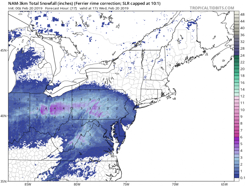
16 minutes ago, Deck Pic said:
NAM is ok... has the DC flip sometime between 10 and 11, probably closer to 10...I like 2-3" before flip and maybe 0.5" sleet on top...on the flip side, it is a cold run, so frozen probably well into mid afternoon...
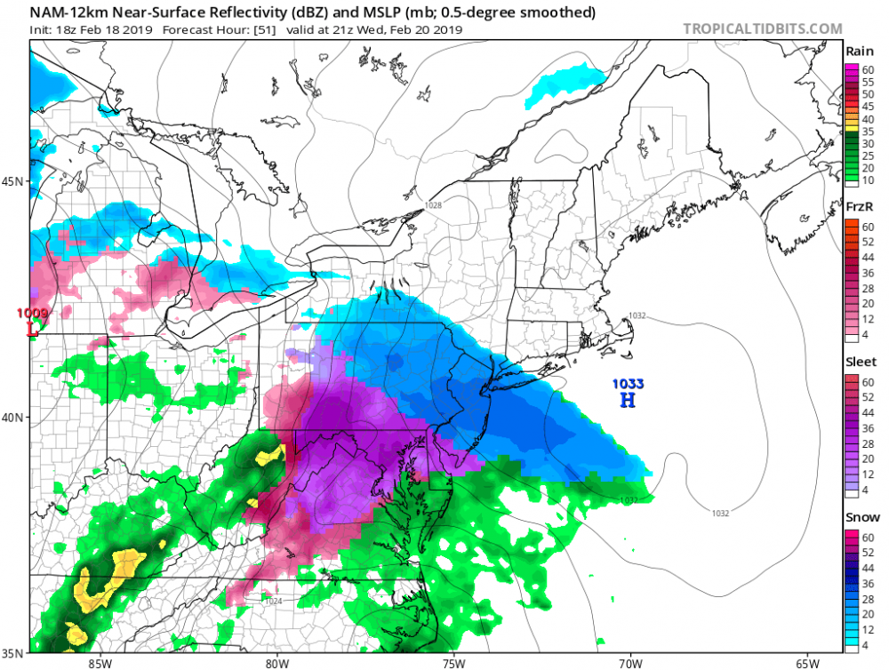
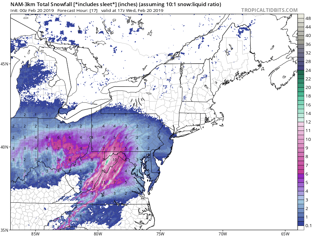
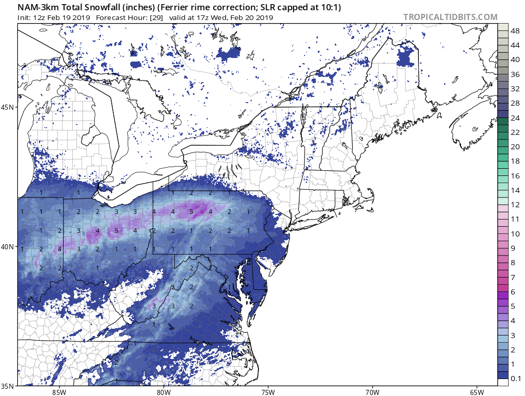
Yep. Check out the 18Z NAM3 Ferrier-based SLR snowmap through 16Z -- lots of 2-3" totals -- some near 4" -- here before the flip to sleet for most in the urban corridor.
-
2
-
-
11 minutes ago, psuhoffman said:
NWS must be weighting the GFS/FV3 a LOT in its forecast... only way those bullish numbers make a lot of sense.
I know I'm biased since I work there, but one thing I like to look at is the trend in the WPC probabilistic guidance. What looked like a bar of 4" here in the urban corridor from yesterday's PWPF is now closer to 2-3". 4-6" here in central-northern AA feels like a pipe dream. If this were deal or no deal, I'd sign up for 4" right now, but instinctively I think 2-3" would be more realistic. In fact, I think there's a better chance of 1-2" of snow before sleet here than 3-4". Hope I'm wrong.


-
2
-
-
It still very much feels like a 2-4" thump for most before a layer of sleet and a coating of ice for us along the urban corridor. Hoping for closer to 4" with the snow IMBY, but I have a feeling it'll be closer to 2-3" before the flip.
-
1
-
-
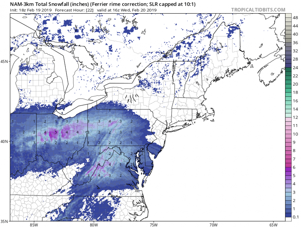
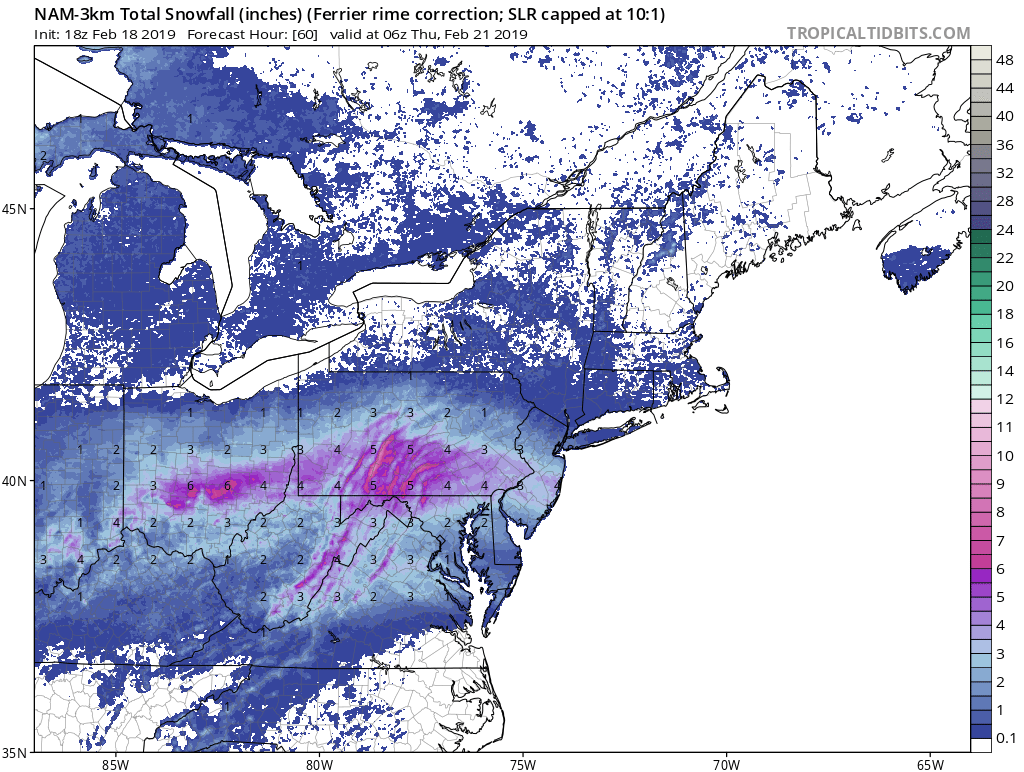
12Z NAM3 continues to be underwhelming with the QPF prior to the changeover (~17Z). Generally .15-.20" liquid equivalent. I trust these Ferrier-based SLRs implicitly when riming snow and eventual ptype issues arise, but I still think the continued 1-2" general area-wide average for the cities and I95 corridor through 17Z is lacking with the QPF. I hope so, anyway.

-
9 minutes ago, snowfan said:
3K NAM isn't much different than 18Z for the DC area. Not entirely sure what people are looking at. It's 2-4" snow with a change to sleet.
Yep. In line with the Ferrier-based SLR snow map from the 18Z NAM3. Though I think if the precip isn't as lackluster prior to 16-17Z as the NAM3 suggests, most of us can get closer to 4" (or more) of snow vs. 2".
-
1
-
-
Well, all I can say is I hope this is the absolute lowest amount of snow possible. It's the Ferrier-based SLR snow map from the 18Z NAM3, which would factor in ptype transition and thus a reduction in SLR. Think (hope?) this is a bit too much of a reduction, but it does give some pause to some of the clown maps out there that are probably overly optimistic with the high end amounts.

-
7
-
-
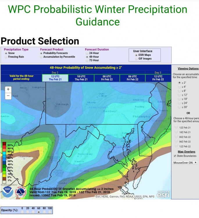
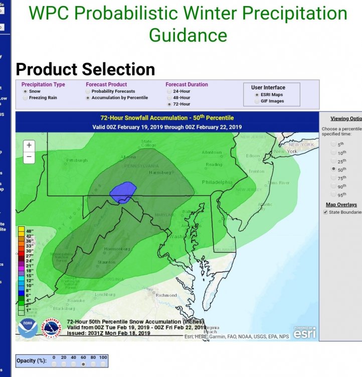
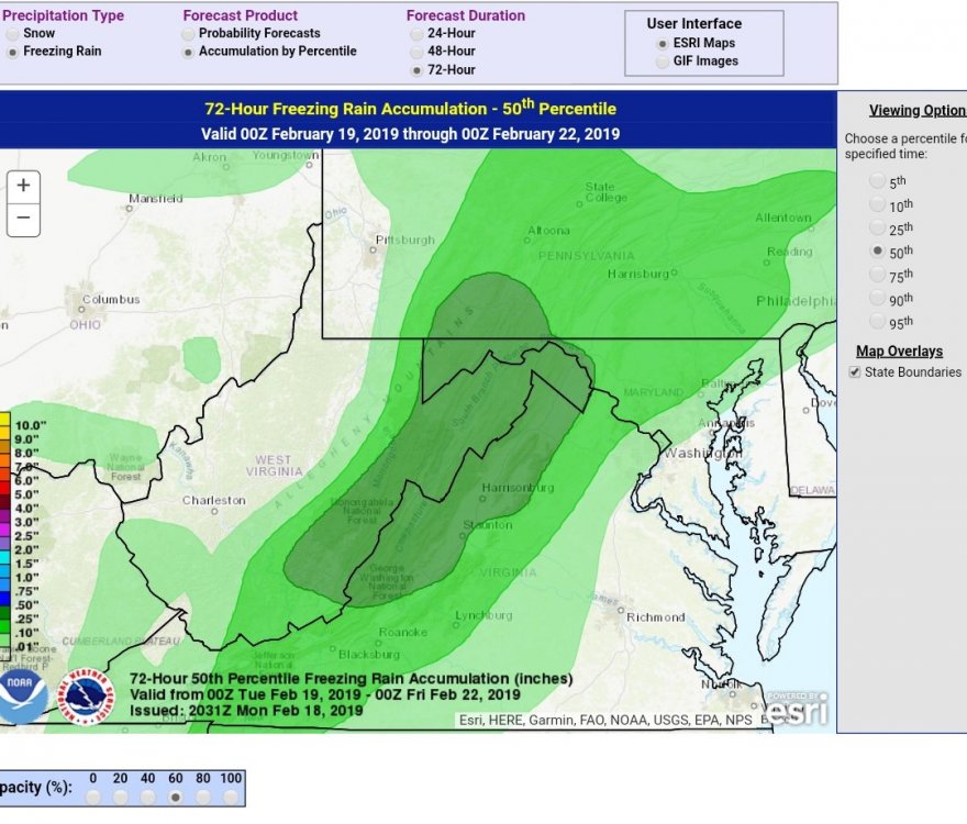
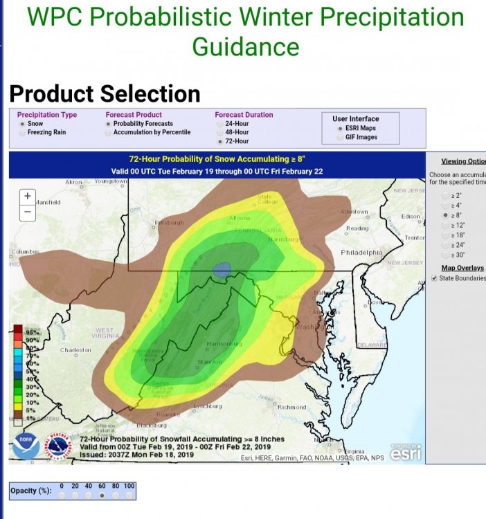
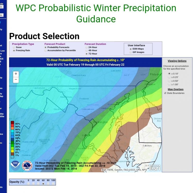
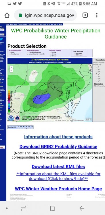
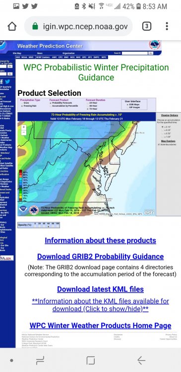
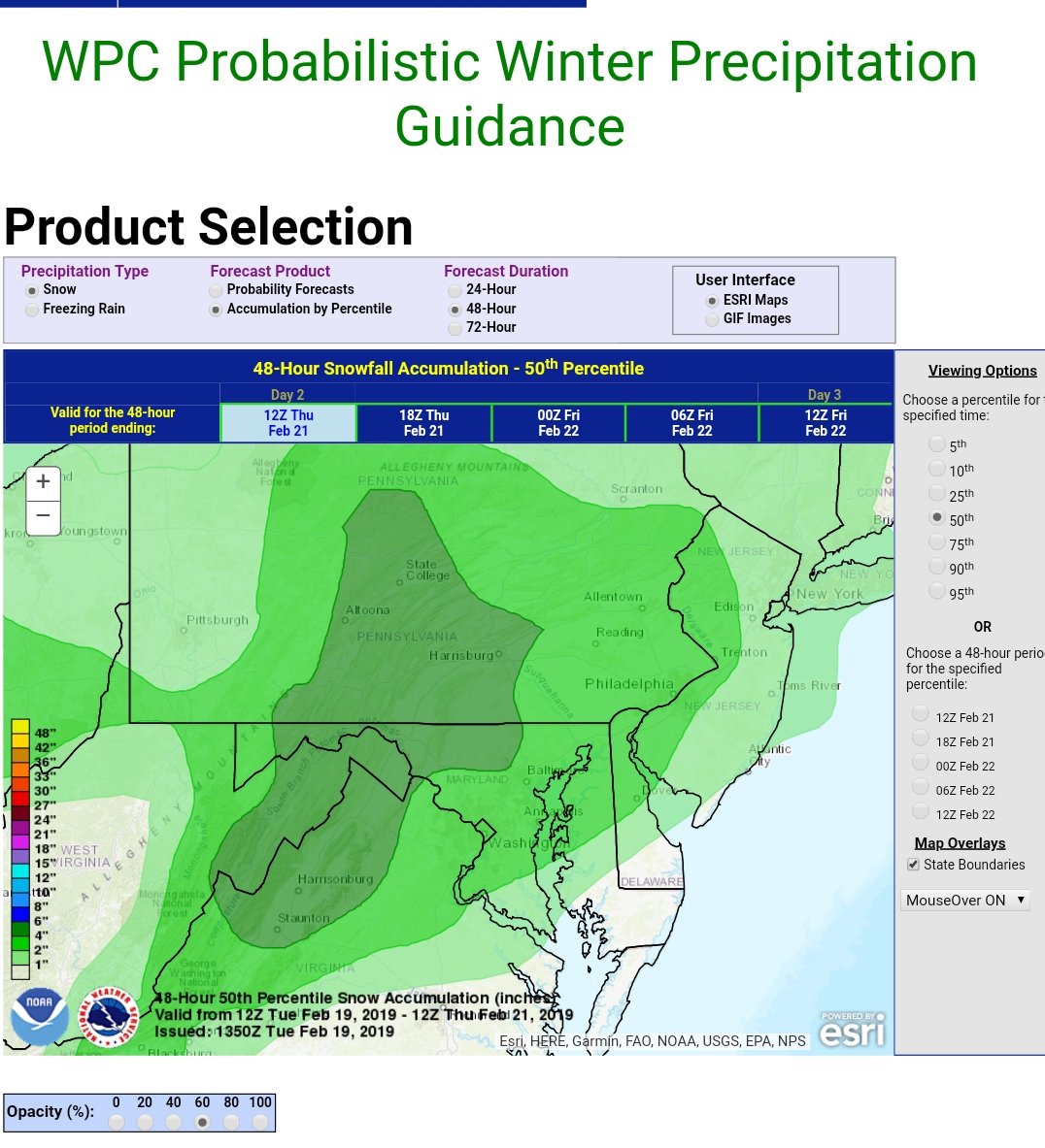
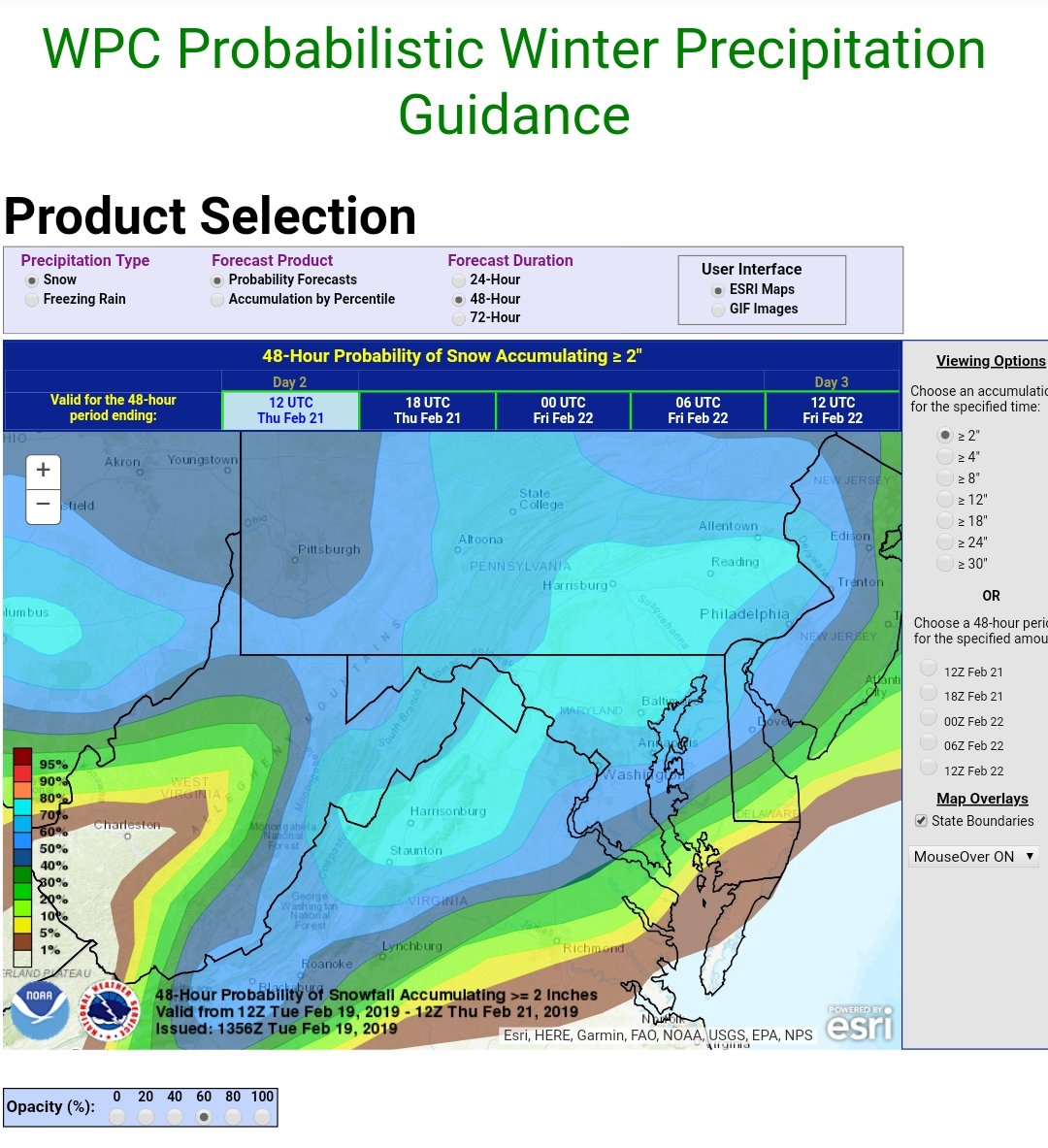
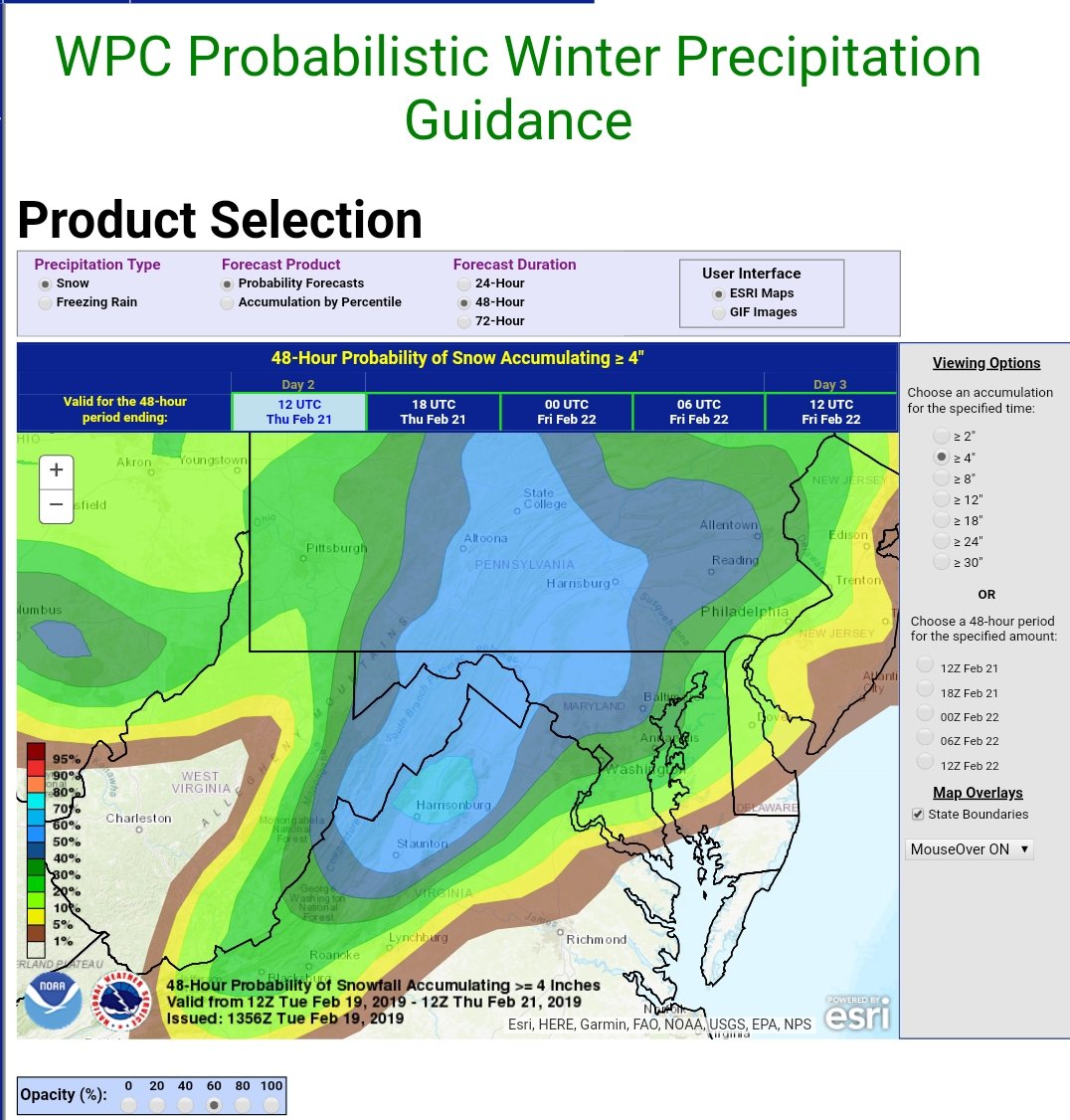
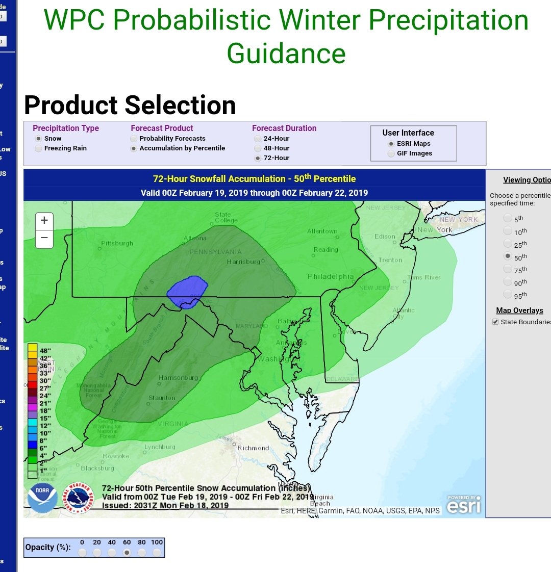
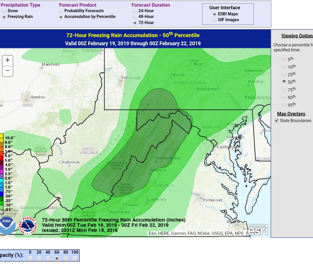
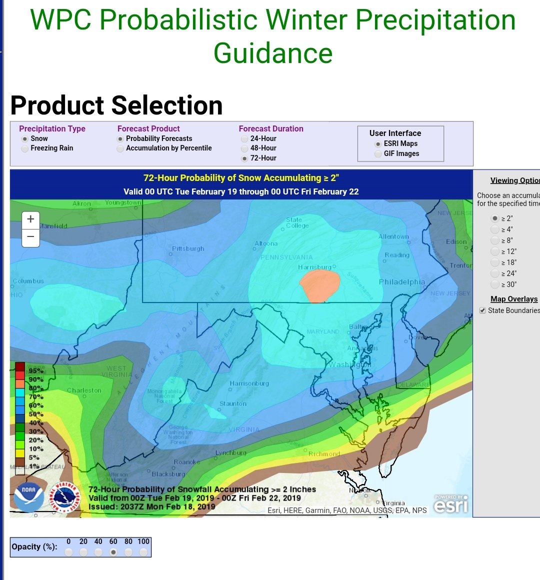
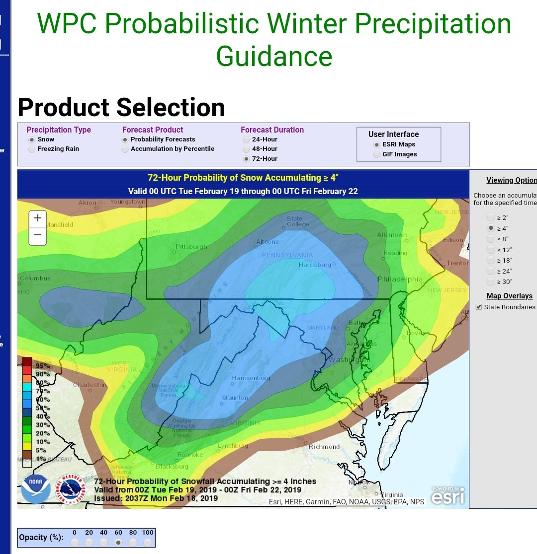
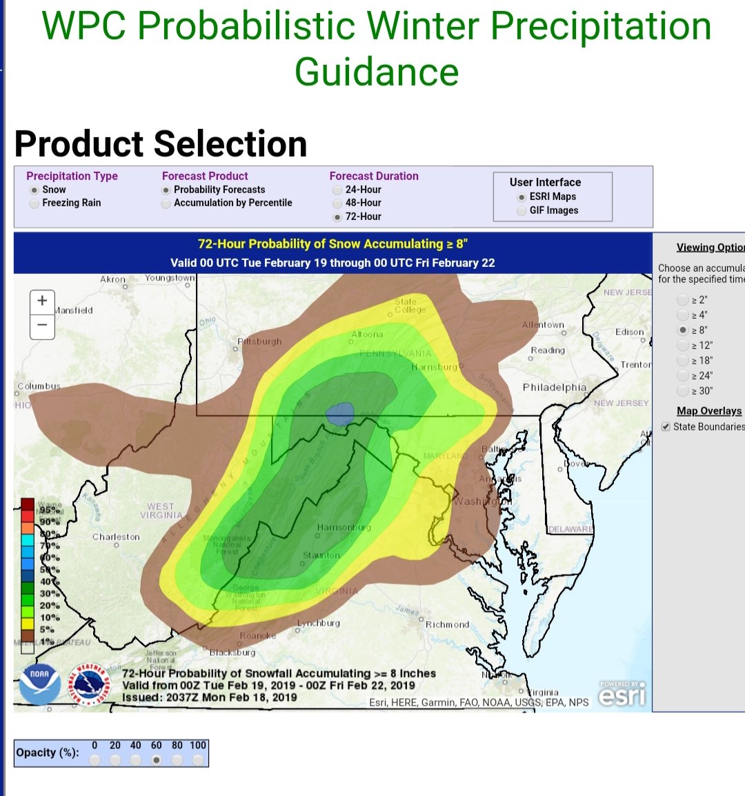
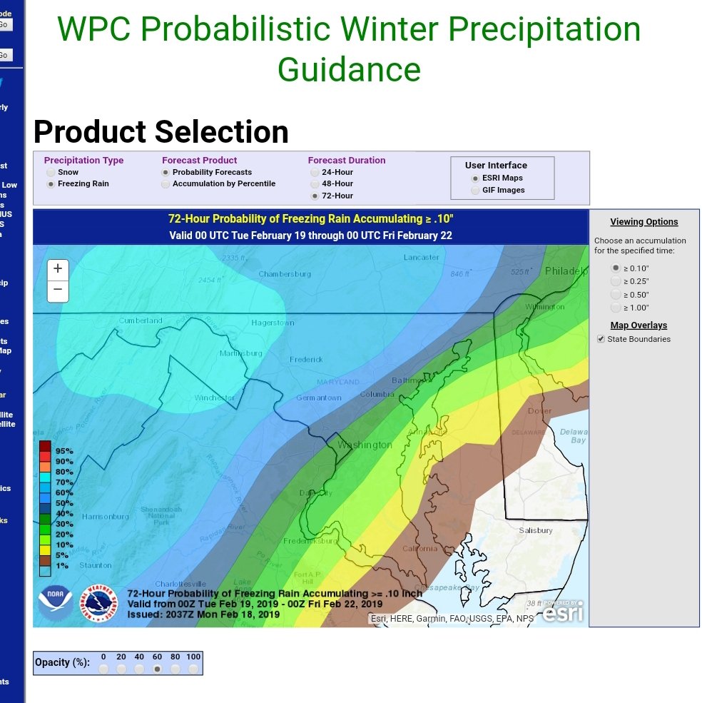
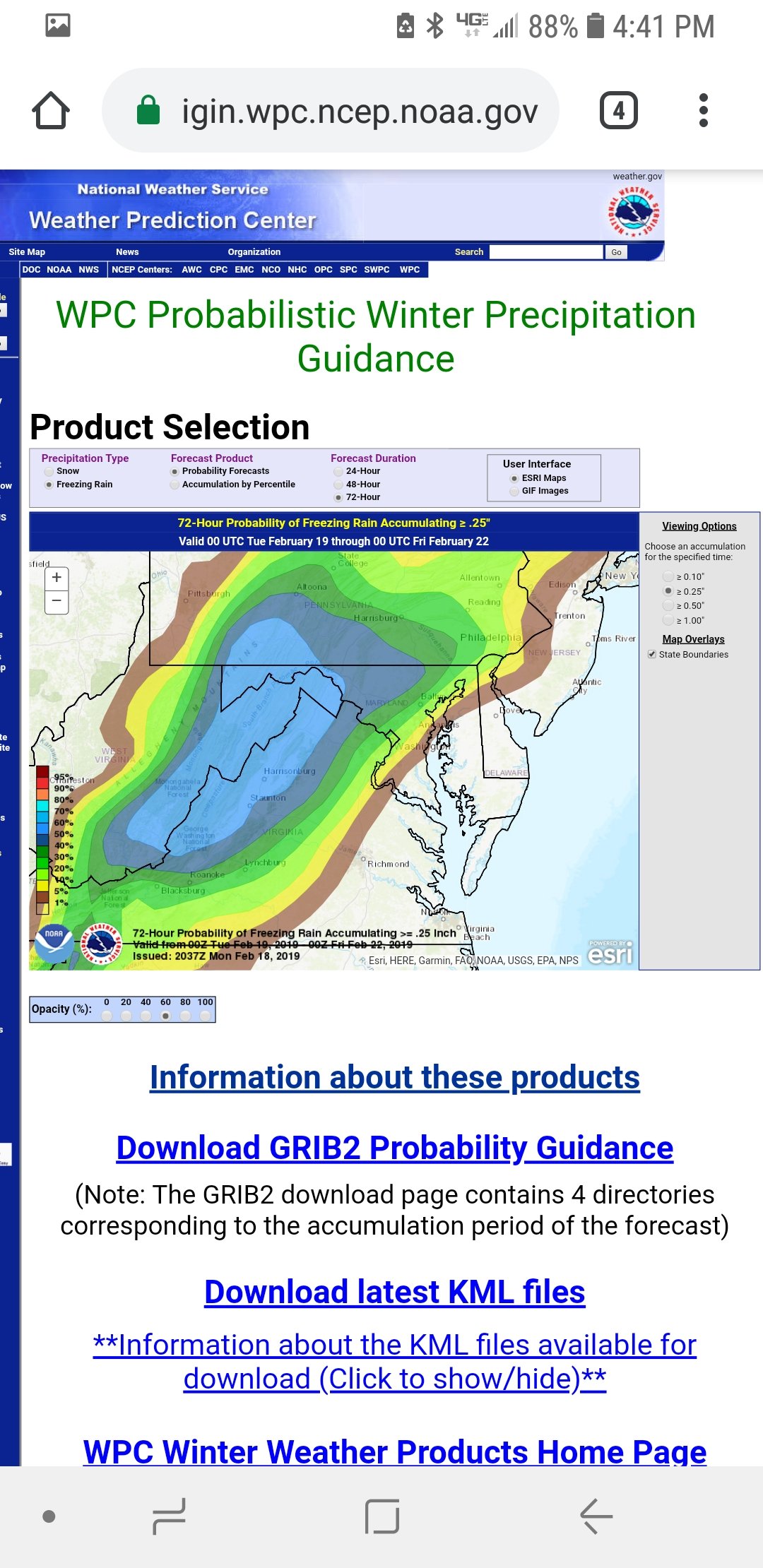
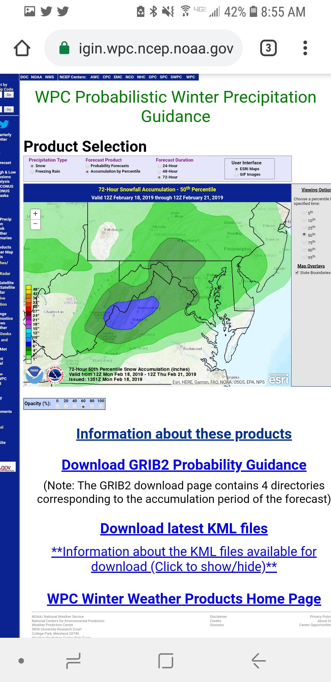
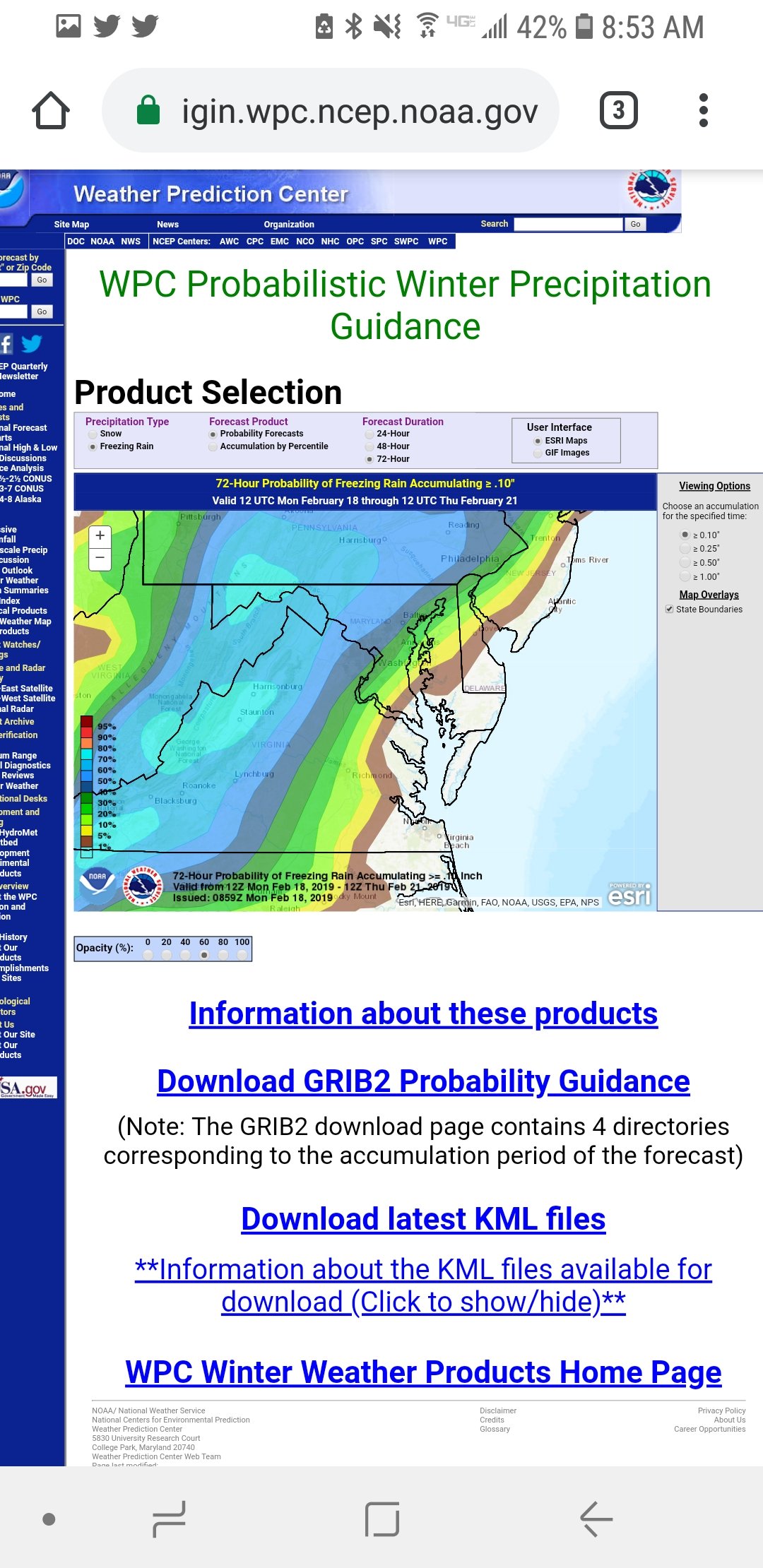
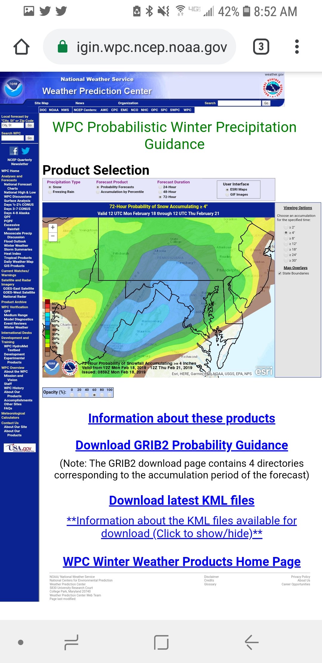
Latest WPC probs, (00Z based, though they do not include any of the 18Z guidance, including GEFS, not the 12Z EC ensembles).
First is the 50th percentile (most likely) snow accumulation, then freezing rain. Might be a touch underdone on the fzra along the I95 corridor. Also notice how quickly those snow probs go down after 4", especially east.

-
Just now, ers-wxman1 said:
Areas out toward Ashburn, Martinsburg, Frederick, Carroll...higher snowfall
Yeah I agree, probably more likely at or above 4", say 4-6", but 8" is really pushing it with this setup (750-700 mb warming, which is completely independent of the strength if the CAD down below).
Still, highly impactful as you noted, especially west of 95. 4-6" snow, plus a layer of sleet and ice accretion to boot.
-
1 minute ago, osfan24 said:
That's what I'm seeing as well, and in my experience in these setups, snow changes to sleet faster than modeled and sleet and freezing rain changes to rain slower than modeled.
Yes, mine too. As far back as I can recall around these parts, which would be the early 80s.
")
-
1 minute ago, psuhoffman said:
Maybe I’m looking at it wrong. I only see about 2-4” across most of our area before it flips to sleet. I don’t really see any big thumpy snow totals until up in central PA. Looks like BAD ice though. Some people are into that.
Same here. I live in Crofton (central-northern AA) and I would LOVE for LWX's current forecast map to pan out IMBY (4-6"). Me thinks it'll more likely be 2-4", and fearing closer to 2-3" than 4".
But we'll just have to enjoy the rest of the precip during the afternoon while surface temps remain below freezing. Very curious to see how much sleet vs. ice we'll all get.
-
Seems to me that for us in/near the cities or along the I95 corridor, we probably have a 4 maybe 5 hr window of accumulatingsnow, taking the NAM timing literally. 7 am through 11-noon. If we can average .50-1.0"/hr during that time, it would equate to 2-4" of snow before the sleet. I have a feeling here in northern AA we'll average 2-3" before the changeover. What happens next (how much accumulating sleet/freezing rain) is a bigger mystery IMO.
-
Dang that's a lot of sleet following the changeover for the cities/95 corridor around midday. As noted earlier -- 850s still below 0C, but layer near 700 climbs above 0C for this corridor by ~18Z
-
1
-
-
14 minutes ago, stormtracker said:
Yeah, I keep forgetting about the 3k! Thanks for the reminder. One should hope that the better resolution would be a ton better. I'm watching the surface temps closely. At this point we know it's not going to be all snow and we're going to changeover. But we do have a chance to hold on to the surface longer than modeled now.
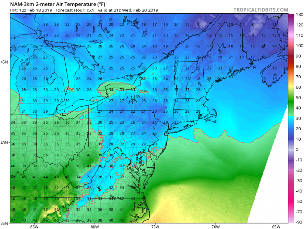
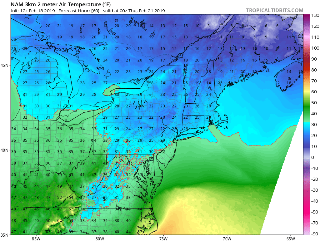
NAM3 sfc temps at 00Z Thurs. Certainly not ideal for appreciable ice accretion, especially with higher rates (which more runoff). But, light fzra or fzdz at 32°F is certainly more efficient, especially on elevated surfaces, as we saw with the recent event in/near Mt. Airy.

-
3 minutes ago, stormtracker said:
Yeah, I keep forgetting about the 3k! Thanks for the reminder. One should hope that the better resolution would be a ton better. I'm watching the surface temps closely. At this point we know it's not going to be all snow and we're going to changeover. But we do have a chance to hold on to the surface longer than modeled now.
Totally agree! Here's what the NAM3 has at 21Z We'd for 2m temps.
-
3 minutes ago, stormtracker said:
Damn, NAM trying to keep even the city frozen until 7pm. Haven't looked at the boundary thermals, but it's probably like 32 and rain. So realistically, if we can hold until like 4pm, I'd consider it a win. Hell, it's already a win with some sig front end snow.
...and wait 'till the NAM3 goes out into the 57h and beyond range. Much better vertical resolution than the 12km version...will simulate surface temps (degree/depth of CAD) much better.
-
1
-
 1
1
-
-
9 minutes ago, ers-wxman1 said:
There are always surprises in a CAD wedge. Some are not ever progged in the guidance. We are moving into the timeframe where the high resolution models better handle these setups. Global become less useful.
NAM3 is especially useful, as it did comparatively well during the last freezing rain event, and especially well during the March 2017 icing event.
The thing is, while the CAD will likely keep surface temps aob freezing for a longer while than most progs, it obviously has no bearing on temps aloft. Which is why there's no doubt an 'upper bound' with respect to snowfall potential before those temps aloft rise above 1C. And that's likely 2-4" for us east of 95.
-
1
-
-
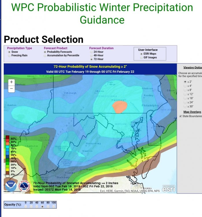
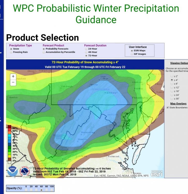
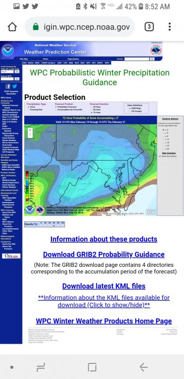
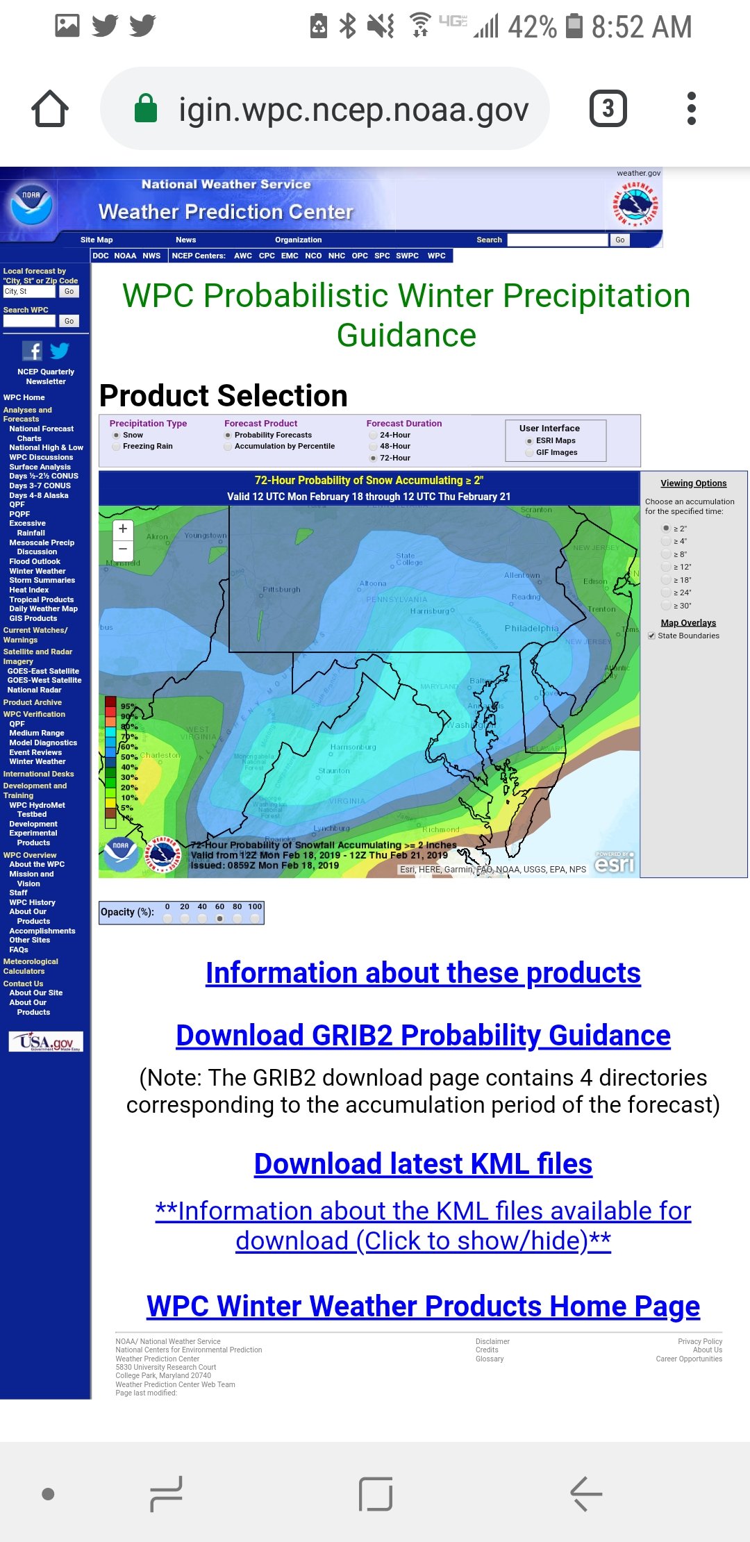
Some of the latest probability maps from my fellow colleagues at WPC. 50/50 (most likely) snow 2-4" east of 95, 4-6+" west. Over 70% probs that we all see at least 2" (so we at least have that going for us, which is nice). Some ice, but certainly a better shot at .10" or more west of the cities. We'll see -- that March freezing rain event in 2017 was certainly an overachiever as the CAD wedge held strong.

-
6
-
-
Round 2 does not disappoint.
5.5" part I
1.5" part II and still coming down heavily!
7.0" total in Crofton
-
1
-
-
55 minutes ago, senc30 said:
FV3 South and landfall at ILM
Which means the "new" GFS core is much closer to the EC and UK compared to the operational GFS and CMC.
Doesn't give one much credence to the current GFS solution..
-
3
-
-
Felt it here in Chester, while in the bathroom (of all places!) Actually felt the first wave, though barely, then soon after the surface wave, which shook the mirror.


2/19-20 Winter Storm Observations
in Mid Atlantic
Posted
Nearing 3" in Crofton. Still ripping, though the snow is definitely riming. No pingers yet.