

Neblizzard
-
Posts
1,091 -
Joined
-
Last visited
Content Type
Profiles
Blogs
Forums
American Weather
Media Demo
Store
Gallery
Posts posted by Neblizzard
-
-
1 minute ago, e46and2 said:
pdii had a min pressure of like 1010mb. this is about gradient with the high, and thermal overrunning, both of which should produce a storm more intense than the minimum pressure may suggest.
Exactly. You don’t need a strong storm with the amount of moisture this storm will tap into. Having a massive high to the north will generate strong winds even without a very deep surface low
-
 1
1
-
-
Just now, weatherbear5 said:
Honestly, in that look, it looks more like a front-end dump which would be mostly snow and then changing over. Would still be good accumulations even for the coast
A good move from 6z for sure. Hopefully that trend continues for the rest of the 12z suite
Yes it’s much better than 6z. The high is stronger to the north and trends at H5 were a step in the right direction. I would take that run as a positive for the metro.
-
1
-
-
Just now, friedmators said:
NAM is better but H5 still closes off over PA eventually.
It’s a colder solution and a shift south . Onto the GFS...
-
1
-
-
5 hours ago, Damage In Tolland said:
Snower after snower
The period from Christmas to New Years looks really good on the EPS. Robust PNA ridging coupled with an -AO/-NAO. Hardly La Niña like...
-
1
-
-
9 minutes ago, sussexcountyobs said:
You can keep the wind. I don't want it
It adds to the ferocity of a storm. Nothing like strong winds and heavy blinding snow.
-
1
-
-
Just now, HVSnowLover said:
This is becoming like a 10 hour event but it really dumps for a short period of time.
Canadian and GFS are 14-16 hours in duration
-
2 minutes ago, Nibor said:
I think that's the first run of the euro where it closed off at 500mb. 0z CMC did so as well a little further south than the euro.
Also notice the enhanced PNA spike, very encouraging trends
-
1
-
-
24 minutes ago, rclab said:
That is wonderful. I also remember Storm Field. That would be a great name for a forum members child. Although, my lost love would have made sure I was gelded if I tried. As always......
My brother and I met storm field several times when we used to visit Larry Cosgrove at UPN 9. Two class acts
-
2
-
-
26 minutes ago, Allsnow said:
Incredible look at h5 on the euro for the mid week system
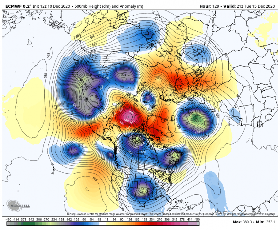
50/50 low and -NAO are your friend so far. Hopefully that look holds. I’ve been saying getting the SV to weaken enough is our best shot at fending off this La Niña. We’ll see...
-
1
-
-
5 hours ago, snowman19 said:
The GEFS and GEPS have completely lost all of the high latitude blocking (-EPO, -NAO, -AO) in the long range, I strongly suspect the EPS will be next. This is shades of last winter when the EPS would insist on high latitude blocking mirages in the long range, run after run, only for them to completely disappear as you move forward in time
Models can’t be trusted 24 hours out let alone 15 days out. It’s amazing you always post when they show an unfavorable solution for snow. The models are finally predicting warming closing in on the polar stratosphere . If the PV stretches then cold air can plunge south mid-late December into January for the east.
-
6
-
 1
1
-
-
1 hour ago, snowman19 said:
The new Euro seasonal is as ugly as it gets. Dec-Mar are a total disaster
I see you’re back in full force hoping for another blowtorch . Glad to see you posting again.
-
1
-
 4
4
-
-
6 minutes ago, NJwx85 said:
The 18z 3k NAM has two lines moving through the area, one around 00z and the next one at 06z. The line moving through CT smacks Suffolk.
Actually now that I’m looking storms are firing in western NY state. That could be our shot later on tonight
-
3 minutes ago, ny10019 said:
looks like NYC metro is missing out on everything again today?
Yes the warm front and best dynamics is further north than what the models were showing . Perhaps we can get some scattered convection between 6-9pm. If not the threat is done.
-
 1
1
-
-
36 minutes ago, forkyfork said:
we're too far away from the warm front imo
So another bust incoming? Horrible
-
1
-
-
8 minutes ago, Snowlover11 said:
upton really backing down on the rain.
That’s been the trend for the last day
-
5 minutes ago, Brian5671 said:
quick hitter on the nam-precip is done by 7-8pm tomorrow eve

This was always was a fast mover I don’t think anyone is shocked by that
-
13 minutes ago, forkyfork said:
these don't go far inland as they ride north unless a powerful block/phase forces them
How much you thinking for our area ? I’m in union county as well . 3-6 inches of rain ?
-
1 hour ago, forkyfork said:
as soon as we heat up this afternoon storms are going to fill in. no cap and a moist profile
Yup sun is coming out now , that was one of the concerns . Instability is rising .
-
2 hours ago, RU848789 said:
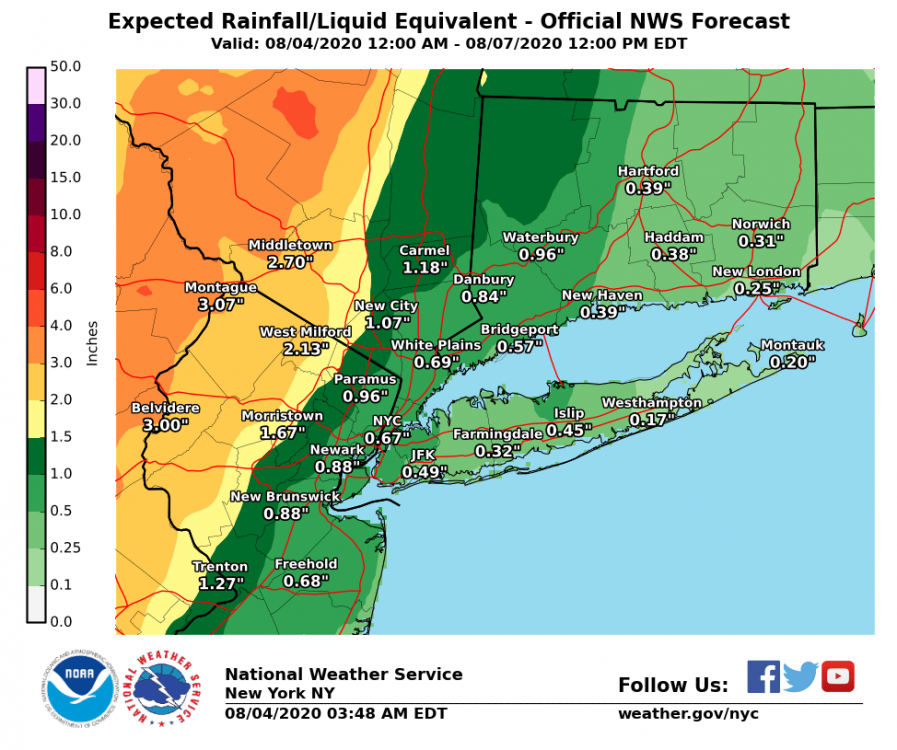
Two camps in the 0Z suite. Camp 1 shows about 2-4" of rain for most of the Philly-NYC corridor (and points within 50-75 miles of 95) on the GFS and NAM with the low coming right up along the coast, while camp 2 has 1/2-1" of rain on the Euro (which was showing 2-4" of rain for the area in its previous two runs) UK, and CMC (less well inland, with the 1" amounts at the coast) with the track 100+ miles offshore, for what it's worth. More tracking on tap...
The 6z NAM has the low going right over NYC. Perfect track for 3-4 inch rain totals.
-
29 minutes ago, Animal said:
12z nam backed of qpf
Doesn’t matter , it’s now casting time .
-
13 minutes ago, snowman19 said:
Of course as soon as Upton bumps up expected totals, the NAM backs off: https://www.tropicaltidbits.com/analysis/models/?model=namconus®ion=neus&pkg=asnowd&runtime=2020011718&fh=48
Since when is the NAM been God like this winter?
-
6 minutes ago, EastonSN+ said:
Would be terrible if we waste a negative NAO and AO period due to a crappy pack. We are going to see a great storm track ex on GFS with all rain.
We need that vortex south of Alaska to slow down or retrograde. If that can happen we’ll build some ridging out west. The negative NAO looks great but the pacific can do it’s damage with this set up.
-
1
-
 1
1
-
-
2 hours ago, HeadInTheClouds said:
Here we go again. The GFS is the only model that shows a cutter and even that scenario would still cause an extended period of frozen precip north and west of NYC before changeover to rain. Every other model shows a colder solution right now.
Yes it is the only model showing this scenario. Pay no attention to snowman19s posts. He’s like a parrot every winter.
-
2
-
-
1 hour ago, SnoSki14 said:
If you like a lot of winter rain then this is the pattern for you.
I suppose there's a chance the weekend storm acts as a 50/50 for the following system but there's no block around to hold the 50/50 in place so tough luck.
Not sure what you’re looking at. The ensembles have a robust -NAO building by day 8. Whether that happens or not is another story


December 2020 General Discussions & Observations Thread
in New York City Metro
Posted
Exactly. Why would anyone trust models 7-10 days out?