

Orangeburgwx
-
Posts
2,592 -
Joined
-
Last visited
Content Type
Profiles
Blogs
Forums
American Weather
Media Demo
Store
Gallery
Posts posted by Orangeburgwx
-
-
Just asking, but do you think all the models are going to be blindsided with the pattern change and not catch it until it is within 3 days?
-
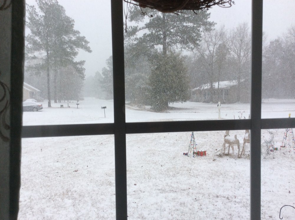
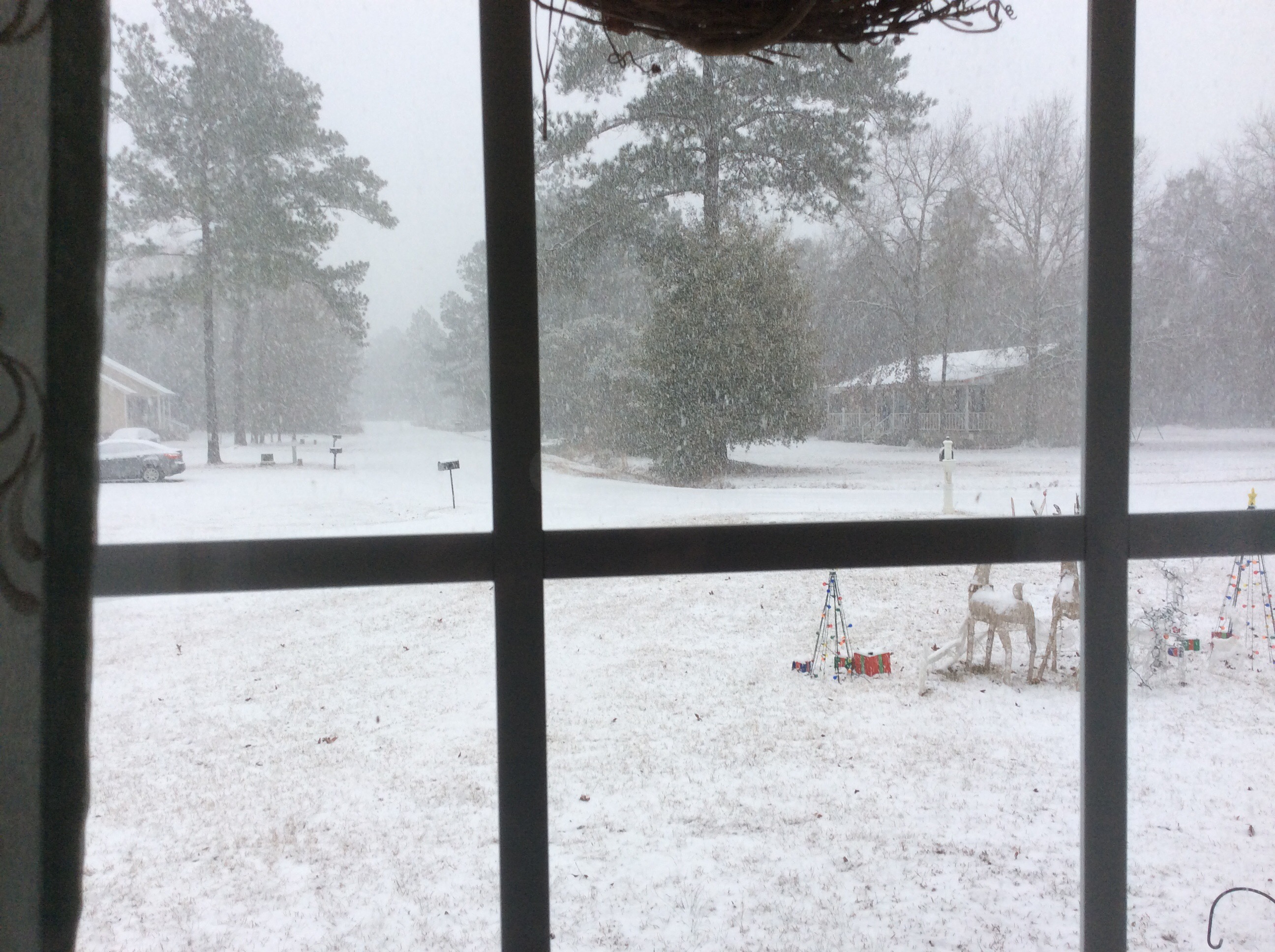
Guys I apologize for waiting a full month to post this, but I had to wait for my upload size allowed to build up enough. This pic was taken during the height of the Coastal Crusher, I had 2”/hr snowfall rates at its heaviest. I figured that seeing a nice blanket falling would bring everyone’s hopes up that we will get AT LEAST one heavy hitter before winter ends. Good luck everyone and I hope we get a board-wide big dog!


-
 1
1
-
-
15 minutes ago, Eric said:
It's not often Charleston's season-to-date snowfall exceeds DC's.
Charleston - 5.3"
Washington National - 3.1"
Dulles - 5.0"
Im at 5.4” so even I have had more snow than DC...
-
1 hour ago, jburns said:
Yep, but you won't live to see it.
What is the saying then?
-
just curious, but is there some sort of saying about a large flock of buzzards and winter storms? I came home last night to 50-60 of them huddled together.
-
4 minutes ago, AsheCounty48 said:

So close...
I think we can get a decent hit off that with the CAD
-
18 minutes ago, Cold Rain said:
You know it’s a boring pattern when all we got is past storms and basketball.

Might as well recharge the snow shields
-
1
-
-
Just looking at the 12z 2m GEFS run shows a dominant SER all the way to Feb. 7th, then cold takes over. Will trend colder due to CAD I believe but overall look is way better than the 6z suite.
-
1
-
-
CAE NWS latest output
&&

.LONG TERM /MONDAY THROUGH FRIDAY/...
After maybe a few lingering light sprinkles early in the
morning Monday, drier and cooler air will once again return to
the area through Wednesday as high pressure at the surface
dominates. By Thursday the upper pattern flattens out and then
turns more southwesterly once again ahead of the next rain
maker. This next front is expected to cross the region Thursday
night and Friday. Temperatures cool through Tuesday, then
gradually warm, and return to near or above normal by Thursday.
Colder air will move in behind the front Friday night. There is
a lot of uncertainty at this point, but if enough moisture
lingers into Saturday morning, there could be some light snow to
the north. Have kept mention out of the forecast for now.
-
17 minutes ago, Cold Rain said:
Yep, it might never get cold again. That is definitely within the realm of possible outcomes. Not sure that I would tag it with a high probability marker, but you can’t deny that within the universe of all possible outcomes, eternal warm weather is one.
especially in our part of the CONUS
-
6z GFS took all of us to Heartbreak Hotel... torch
-
24 minutes ago, mackerel_sky said:
Isn't it NAM time? For Tuesday's blockbuster???
")
NAM runs tomorrow will be a better guideline
-
I like the look at the end of the GFS
-
4 minutes ago, burrel2 said:
It hasn't been that good for everyone in the Southeast... maybe that's why some are gnashing teeth more than others.
yeah, that is something when the eastern half of the Carolinas (North and South) have had a better winter than the western half
-
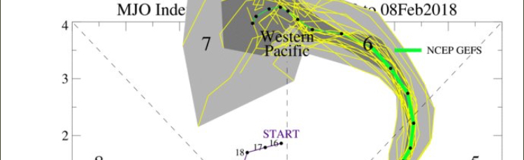
omg the GEFS MJO update... off the damn chart
-
1 hour ago, Snow dog said:
If you are waiting for a storm to dump several feet of snow in Orangeburg, SC, your wait might be quite long, because that's not happening. I've lived in the upstate of SC all 47 years of my life, and have only seen a 12"+ snow (1988). Some peoples' expectations are hilarious to say the least...
I am happy with an inch a year, so anything more than that and I’m satisfied. Luckily I’m sitting at 5.4” total so far
-
28 minutes ago, Upstate Tiger said:
I don't understand all the wailing and gnashing of teeth on here right now. We are at our below average the next 10 days after this weekend. There is also a potential threat showing up for next weekend and the indices look even better after that. It turned cold the second week of November and except for a few brief warmups it has been cold since then. We have had a 3" snow before Christmas and a 5" snow in January plus a number of morning with single digit lows IMBY. I have been closely following winters for 41 of my 53 years here in the SE and this one has been a good one by SE standards. Even "great" winters here in the SE are usually front, middle or back loaded. We still have possibilities heading into Feb. It is quite unusual for us in the SE to go multiple months with threats of winter weather. Enjoy it folks, it's a rare thing.
You raise a good point, even I saw a few flakes before Thanksgiving (first time in my life I have witnessed that). I think the main reason there is so much gnashing is because we are snow hungry, most of us are way overdue (myself included) for a major winter storm that dumps several feet of snow IOBYs.
If you think about it, the pattern goes back to LAST winter, Savannah got snow showers around St. Patrick’s Day for crying out loud (I was there). Then our summer was cooler than the last few years m and rainy, IMBY anyway, then followed up with the pattern flip at the end of October that set us up. Keep in mind, this is a LA NIÑA winter, just imagine if we had this set up with a weak El Niño...
-
1
-
 1
1
-
-
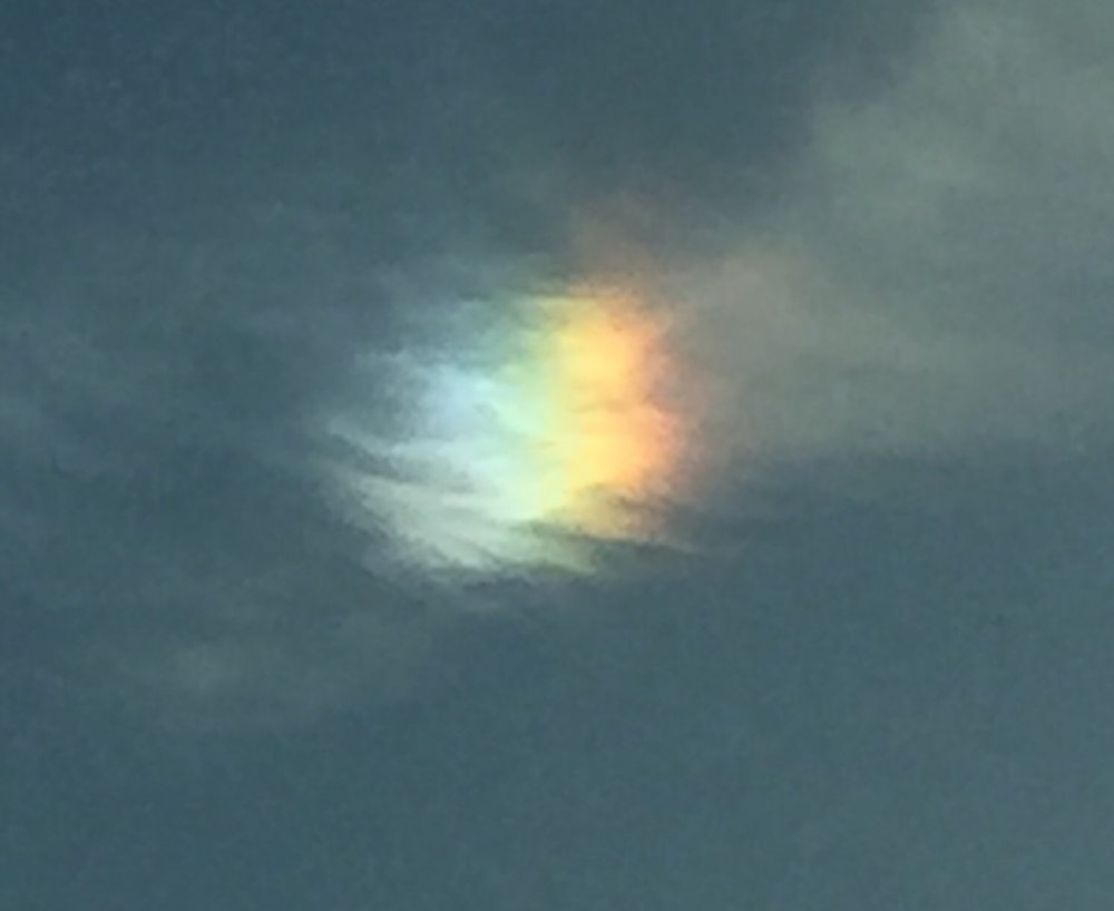
took this picture while on the way to the doctor this morning
-
2
-
-
57 minutes ago, BIG FROSTY said:
JB, this morning, comment on the Euro!
He thinks the Euro is cold, but not cold enough!!
He said Right now, the MJO is loaded for bear in the warm phases and the result has been the thaw that we are experiencing........
So During the second week of February, the precipitation pattern looks like its into Phase 8....
He thinks we are starting the step down period here, and the coldest 20 days comes February 17 - March 7. The slow move of the MJO will extend cold well into March.
There is still warmth in the first few days, but this is headed toward our analog. With bitter cold ready to come down from the arctic, once the MJO lines up, a similar evolution with the magnitude of cold should occur.
The teleconnections have a deep negative EPO developing quickly, which suggests the Euro's Week 2 & 3 temperatures are suspect, as that would favor more cold farther to the east............................. Guess we'll see pretty soon!
Hope everybody has a great day!
wow, the sure does sound optimistic AND it buys us another month of possible storms
-
1 minute ago, downeastnc said:
The last storm didn't get modeled well until 48 hrs out and was not even on the radar really 5 days out or so....its funny folks are putting stock in the GFS after 144 hrs much less 300+....once the pattern change actually starts the GFS and every other model will go wall to wall cold but I doubt they really show it well until mid next week.....its like folks don't remember the models did the exact same thing just 1 month ago with the last cold outbreak.....or that models typically have trouble resolving pattern changes and try to flip back to the existing pattern instead of locking into the new pattern.....its like that literally every single time there is a major change in the pattern.
some think the models are golden and true, but they can’t beat God (NOT trying to stir a hornet nest, was just stating my opinion.)
-
1
-
-
11 minutes ago, mackerel_sky said:
GFS was a dumpster fire
It was the 6z GFS (which typically runs hot anyway) and the end of the run is still on the 11th. If deep cold hasn’t shown up by this coming Wednesday THEN we can call torch. Go look at the 6z GEFS, the 2m and 850mb temps trended colder compared to 0z.
-
-23 near the WIS/CAN border at 240
-
shift it south and I will be satisfied, but you NC folks will be happy
-
1
-
-
STRONG apps rubber at 186

Mid to Long Term Discussion 2018
in Southeastern States
Posted
******* SER keeps all the good stuff to my north...