

Orangeburgwx
-
Posts
2,592 -
Joined
-
Last visited
Content Type
Profiles
Blogs
Forums
American Weather
Media Demo
Store
Gallery
Posts posted by Orangeburgwx
-
-
6:00 PM EDT Thu Sep 13
Location: 33.9°N 76.3°W
Moving: WNW at 5 mph
Min pressure: 955 mb
Max sustained: 105 mph
-
7 minutes ago, Solak said:

Looks like that would be a direct hit on Emerald Isle
-
Just now, rjtysinger said:
Let me guess, you’re from SC! Any scientific proof or just wish casting? I had a post deleted yesterday for wishcasting it to you!
The center blob looks like it is moving almost due west right now, that plus slowing in forward speed might kick it further down south-southwest west. This is going to be a long day and night for everybody, so even nowcasting is wishcasting.
-
GFS, to me, ran the system in too high imo... I think it dives down further into SC than that last run showed because it is really slowing down now
-
 2
2
-
-
IR and Dvorak continue to improve by the minute
-
11 minutes ago, ILMRoss said:
I think that you need a much smaller storm in order for that to really have an effect.
I don't know man... Last 90 minutes or so the IR and Dvorak looks better
-
1
-
-
Eye seems to be drifting west the last 30 minutes or so
-
From my NWS office:
FridayTropical storm conditions possible. A chance of showers and thunderstorms, mainly after noon. Mostly sunny, with a high near 91. Chance of precipitation is 40%. New rainfall amounts of less than a tenth of an inch, except higher amounts possible in thunderstorms.Friday NightTropical storm conditions possible. A chance of showers and thunderstorms. Partly cloudy, with a low around 72. Chance of precipitation is 30%. New rainfall amounts of less than a tenth of an inch, except higher amounts possible in thunderstorms.SaturdayHurricane conditions possible. A chance of showers. Partly sunny, with a high near 88. Chance of precipitation is 50%.Saturday NightHurricane conditions possible. Showers likely. Mostly cloudy, with a low around 71. Chance of precipitation is 60%.SundayTropical storm conditions possible. Showers likely. Mostly cloudy, with a high near 85. Chance of precipitation is 70%.Sunday NightShowers likely. Mostly cloudy, with a low around 71. Breezy. Chance of precipitation is 60%. -
Yeah she is really coming in high and hot by a full degree longitude
-
1
-
-
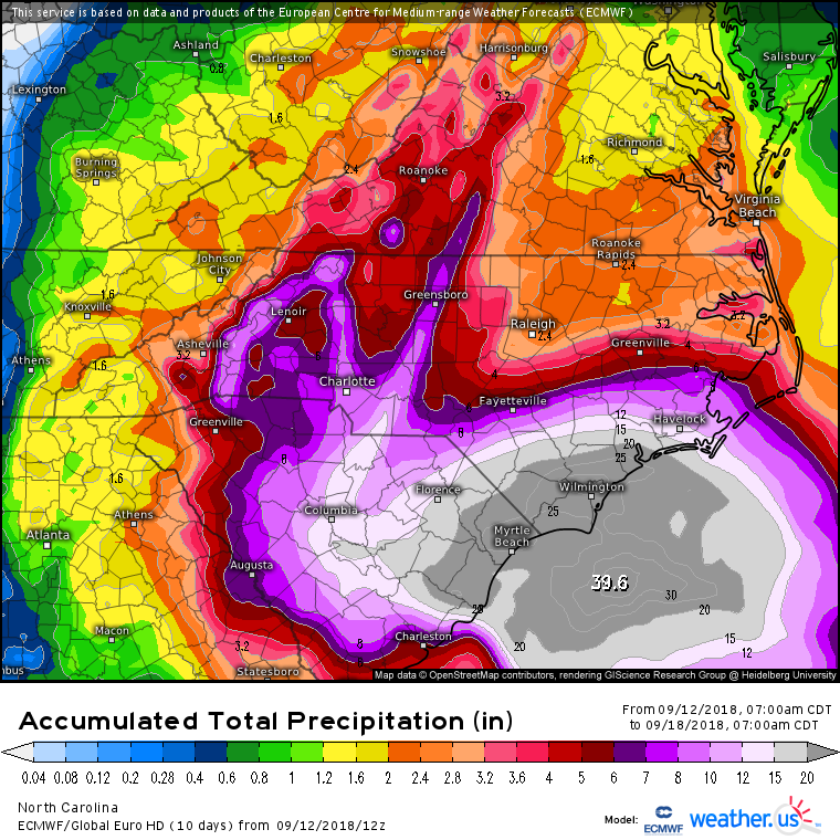
4 minutes ago, griteater said:
Euro Ensemble Mean is much like its last run. Storm moves into Wilmington area, then moves SW, where the mean is actually just off the SC coast (same as last run). This run is slower with the progression SW thru the SC coast...so, an increasing heavy rainfall threat in eastern / NE South Carolina.
Also more time over water (ie the Gulf Stream)
-
13 minutes ago, NC_hailstorm said:
Euro at day 6
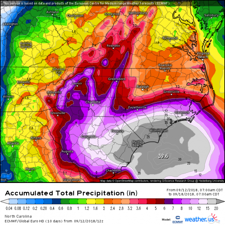
13" of rain for me... The Edisto river is going to flood
-
43 minutes ago, tramadoc said:
I explained the reasoning behind your comment and what Michael Ventrice tweeted. BTW, good to see you brother!! Looking forward to some winter tracking with you again this year.
Sent from my SM-N950U using Tapatalk
I'm looking forward to it too, stay safe during Florence!
-
1
-
-
22 minutes ago, Geno said:
140 mile wide eye? Link to source.
5 minutes ago, Steven_1974 said:There's no way the eye is 140 miles wide. That would be greater than the distance from Wilmington to Raleigh which is only 114 miles.
Here is where I got it from
https://mobile.twitter.com/MJVentrice/status/1039895342609772544
-
1
-
-
-
4 minutes ago, griteater said:
Power Outage forecast - https://twitter.com/JamesBelanger/status/1039888372607721473

70-80% power outage for Orangeburg... Not good since my brother is on a nebulizer
-
Forward motion is down from 17 to 15
-
I'm staying put here in Orangeburg, further inland so not as much winds but I'm interested in the rain totals
-
1
-
-
-
1
-
-
My aunt just texted me with a question that I hope one of you can answer...
"How big is Florence across at the moment?"
-
The crazy SW drift on the GFS would be tossed if it was by itself... But the EURO showed it first with a near identical track with a Charleston landfall
-
12 minutes ago, SENC said:
Ander420, Is in fact Quite Right If you seriously think about this. In todays Political Climate...
With ALL the Major media News organization(s) HYPING up this Storm, OMG End of the World is coming… After being called out & caught-up in many________, ending up with Egg in their faces for the Past Two years... Time after time..
Screaming, now, LISTEN to US! We are [/I]"thinking for you, AND then Tell you WHAT to think & Do"[/I] (It's for the Children you know)..
Gosh dern right the General Public at Large Will in fact Ignore ANY future Warnings.. Until it's to late...
Look at Memes All over the net concerning, & making fun of Jim Cantore, when He shows up before & during a Major Weather event..
Then there WILL be the reasoning that yes, in fact, MSN & Media are "earning" the Moniker of Fake News..
With that said...
Floyd dumped 19.50 +/- inches of Rain here in Wilm.. Ya'll remember what happened then..
I cannot Fathom 25~45 inches of rain with all the Development in the past 3~5 years in SENC..
Destruction would be on the Biblical Type scale.. Floyd AND Fran, times TWO...
So...
Floyd, Fran, Hugo, and Harvey all tied into one?
-
 1
1
-
-
What the actual hell caused the EURO to bury me like that... If the GFS follows suit that would cause trouble
-
Man that eye can't get itself together on the IR
-
Pressure down to 940.8 for the moment

Hurricane Florence
in Southeastern States
Posted
Yep