

Math/Met
-
Posts
235 -
Joined
-
Last visited
Content Type
Profiles
Blogs
Forums
American Weather
Media Demo
Store
Gallery
Posts posted by Math/Met
-
-
Thought I’d give a quick update on the mountain wave event. Already getting some gusts of around 60mph at Camp Creek today, but this isn’t the main event.
There are still a few things that could go hinder mountain wave development this weekend. As Jeff mentioned in the Severe Weather topic, the NAM has shown signs of wanting to keep 700mb winds more southerly. If that happens, then that could hinder the critical layer development (need SW winds at 700). Also, if there is any instability near the mountains, that could also decrease downslope potential. With that said, if everything comes together this could be a very significant wind event. The parameters are some of the best that I can remember. Just talking potential, because it’s impossible to say for sure when you are talking about wind speeds within stationary gravity waves.
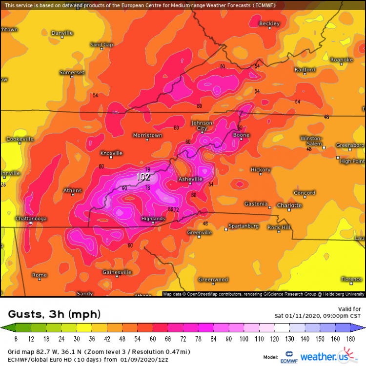
Here is one example of the Euro wind gust output. Not sure how reliable this particular product is, but models always underestimate winds with these events (along the mountains) so it caught my attention.
-
 3
3
-
 3
3
-
-
I know this doesn’t directly impact many people on this forum, but the 12z Euro is showing what would likely be a MAJOR mountain wave event this weekend for East TN. Details can change between now and then, but that looks like a very high end event currently.
-
4
-
4
-
-
27 minutes ago, Blue Ridge said:
My wife, a native of Greeneville, often mentioned the Snow Bubble™ to the point that it became a household joke (hence the trademark symbol :D). Then we decided to move there for a couple of years. Those winters made me believe. Friends in Tusculum and points north and east would do well. Seems like there's at least a 25% difference between downtown and Tusculum during many events.
Greene County has several microclimates and is an absolutely fascinating study.
I’ve seen that many times. Even just 1-2 miles east or northeast of Greeneville can make a big difference. Especially with marginal temperatures.
I drove around NE TN a lot for one of my previous jobs. I was always amazed at how well Jonesborough did, often better than any other low elevation areas of NE TN. You're in a good spot.
-
1
-
-
2 hours ago, Blue Ridge said:
1.5" at home in Jboro. The last couple of bands absolutely ripped as they raced the dry air.
Roughly an inch at the office in Greeneville. Not nearly as much on trees/bushes. The Greeneville Snow Bubble™ is no joke.
From downtown Greeneville to western Greene county can struggle to get much accumulation at times. Areas to the east of Greeneville often do a little better. My obs from last night aren’t far from downtown, but it’s on the eastern side.
I used to complain about the Greeneville Snow bubble all the time growing up. After working near the Tri-Cities airport for a few years and realizing how much they struggle with NW flow events, I stopped complaining so much. Greeneville typically does ok with those, but not as good as Jonesborough. Jonesborough always seems to be a good spot for those events.
Of course, the snow hole really shows up when there is any kind of SE flow across the mountains.
-
2
-
-
Just measured 1.75 inches on a picnic table. Heaviest snow of the event falling currently in Greene County. The band is moving out quickly now.
-
3
-
-
The High Wind Warning was warranted for sure (based on MRX reports), but it wasn’t an impressive wind event for the typical areas. The wind direction at Camp Creek was very erratic during the event. Usually during mountain waves, the wind is consistently gusting from a very stable SE wind direction at CC. I knew that conditions during the day yesterday weren’t the best for mountain wave formation, but I thought conditions would become more favorable during the evening. That never really happened… at least at Camp Creek. My best guess is that there was too much of a southerly component around 700mb, so the critical layer wasn’t really established. Still some downslope/ gap enhancements, but true stationary mountain waves had a hard time forming, based on the erratic wind directions at Camp Creek.
Greyhound, I’m not aware of any data in that area.
-
3
-
1
-
-
Regarding the high wind warning across the mountains and foothills, there have been some gusty conditions so far but nothing too impressive (based on Camp Creek data). The overall atmospheric conditions aren't overly favorable for strong mountain waves yet, but that should change significantly later this afternoon and into tonight as the surface low lifts north. This will put the East TN mountains and foothills in a very favorable position relative to the LLJ location and orientation. The other atmospheric parameters look favorable as well, so there could be some very strong gusts in the usual spots.
-
1
-
-
According to the Greeneville Sun, the UT Experiment Station recorded 0.24 inches of rain in September, which was 3.00 inches below normal for that location. My rain gauge recorded 0.20 yesterday, which brought my final September total to .24 as well.
-
1
-
-
15 hours ago, John1122 said:
Someday this will happen again. I honestly feel like a lot of these totals are underdone. Most all of CC was over 18 inches in the storm. Above 2500 was 36+ here. I believe Oak Ridge was at 18 too, much more than this map seems to imply.
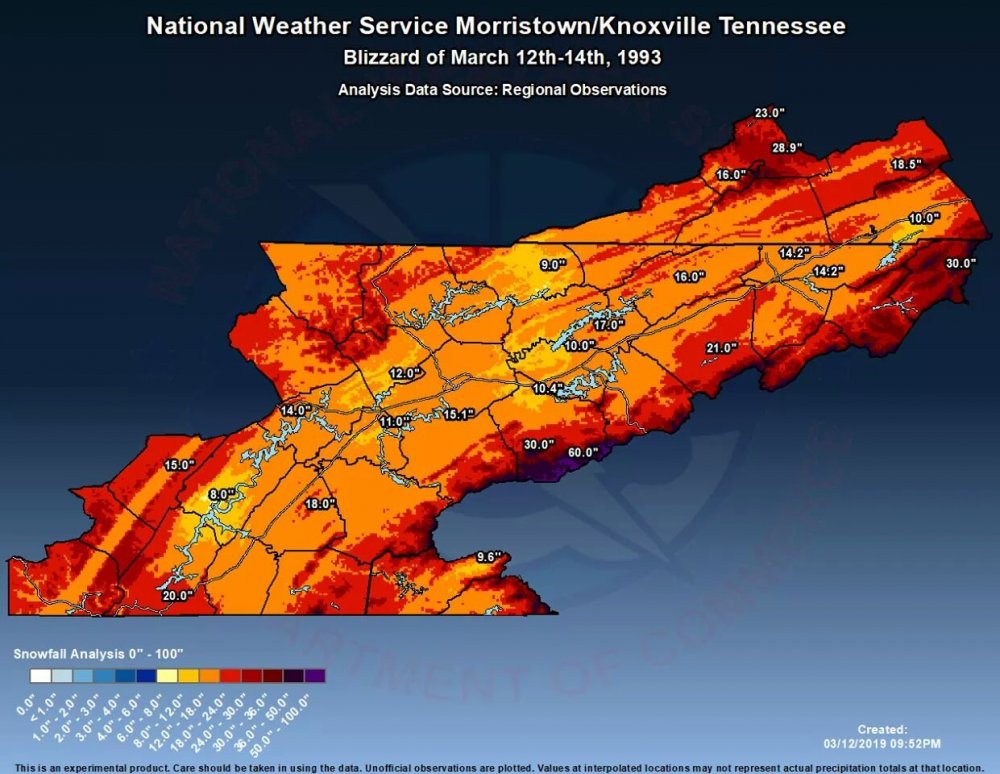
Some of those totals seem a little low, but I have no way of knowing for sure. I think the Greeneville total is pretty accurate. That 21.0 in Greene Co. was likely from the UT Experiment Station. They used to keep daily hand written records. The two biggest snows I saw in their data were 21” in 1993 and 18” in 1998.
-
3
-
-
Recent gust of around 71mph at Camp Creek. The rain overcame the downslope flow and moved over the area, otherwise I think the gusts would have been higher so far.
Edit: Update from MRX discussion.
Quote.DISCUSSION...Quick update to upgrade rest of wind advisory area to a high wind warning. Also included Cherokee and Clay county North Carolina. The strongest wind gusts will occur above 3500 feet with gusts between 60 and 70 mph. Gusts between 70 and 80 mph are possible at elevations above 4000 feet. Decision was made based on HTX and MRX velocity readings. Both radars have consistently been showing 70kts of velocity above 3500 feet and 80kts above 5000 feet. Sevier county electric currently reporting 3000 customers without power. Sevier county dispatch reported much of Gatlinburg without power.
-
1
-
-
Already gusting close to 60 at Camp Creek. How strong this event gets will likely be determined by how effective downsloping is at keeping rain out of the area. When rain moves in, it usually prevents stronger gusts.
-
1
-
-
Winds are starting to pick up along the mountains and foothills. There could be a significant wind event tonight in a few spots. The wind profile on models is more favorable now. I could see an upgrade to a high wind warning being warranted as the event gets going.
-
1
-
-
1 hour ago, Runman292 said:
Playing devil’s advocate here in regards to watches not being taken serious by the general public:
In the case of East TN, a good chunk of Tornado and even Severe Thunderstorm Watches that have been issued for the area end up being unnecessary. A big part of that is due to the storms weakening over the plateau and the instability and wind shear rarely seem to be favorable at the same time in the region. It’s gotten to the point that because a lot of the watches in recent years have turned out to be false alarms, it can give the average person the idea of “Well, they seem to issue watches often and nothing bad ends up happening. Why should I take them serious?” So, I understand why some people are skeptical about the watches.
The link between meteorology and social/behavioral science is an interesting field of study. I'm certainly no expert on that. However, one of my grad school professors was interested in that field. If I remember correctly, the correlation between false alarms and people not responding to the next severe threat was pretty weak. For many people, they will either take watches and warnings seriously or not based on their own personal trust in the forecast(or belief in science in general). That trust is probably independent of any previous false alarms. I'm sure we've all heard people say "they never get it right". That statement is obviously false and they probably know that at some level, but you would never get those people to take shelter during a warning. They would probably need to visually confirm a tornado before they would seek shelter.
-
1
-
-
Just wanted to say congrats to TN fans. I knew today would be tough for UK. UT is a much better team than they showed the first game. As bad as UT played the first game, UK took it to another level of bad today. They were terrible today. Got to give UT credit though, they played with more energy and made it tough on kentucky to get anything going offensively. As a fan of good basketball, it's a shame that neither game was competitive.
Bone was outstanding today. If he plays like that, UT should go a long way in the tournament.
-
4
-
-
2 minutes ago, tnweathernut said:
Yes, it is. He claims he was overseas and found the shirt and just wanted to give Alabama fans a hard time, but I don't buy it. He was much more active wrt questionable calls in that game (29 to 15 whistles in favor of LSU). Barnes wasn't happy and I consider him pretty fair minded and not one to make a big deal out of nothing.
The SEC office knows about it and has put out a statement trying to smooth it over talking about all his accolades as an official. I personally don't think he ever needs to officiate an LSU game again with several questionable calls and several missed calls in favor of LSU. You don't make that foul call with 0.6 seconds left in OT either. He was the one that blew the whistle on that play 80 feet from the basket.
All this said, TN absolutely had chances to put them away and didn't. Kudos to LSU (and their fans) for taking advantage of the situation and pulling out the win.
I saw that picture on social media and originally thought "there's no way that's real". That’s ridiculous..
Regardless of the true story behind the picture, it shows a lack of integrity on his part for even agreeing to do an LSU game. He knew that picture was out there.
-
2
-
-
Is that picture of the ref ( LSU-TN game) holding a LSU shirt real? If so, that's a terrible look for SEC officials.
-
1 hour ago, 1234snow said:
Camp Creek gust of 123mph was ruled erroneous after quality control. Gust was revised to 81mph.
Glad they did quality control and straightened that out. Are they saying 81mph was the peak gust today? Just wondering because it looked like there were legitimate gusts in the mid to upper 80's based on the plot. Not that it really matters at this point, just wondering if all recorded gusts were higher than actual winds.
-
2
-
-
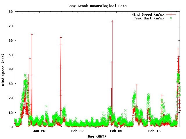
I don’t want to post too much about the mountain wave event, but here is why I think the red data plots are incorrect. If you expand out to a 720 hour plot, you can see errors show up several times. The peak (green) is usually very accurate.
-
1
-
-
I haven't heard any major damage reports, but it looks like there are a lot of trees down in southern Greene County.
Probably not the best idea to be standing there.
-
1
-
1
-
-
1 hour ago, 1234snow said:
All local tv Mets have used the 123mph measurement on social media this morning.
That’s unfortunate. It may end up being correct, but I would be VERY surprised. The near 90mph gusts seem legit. I have a full dataset for research purposes that goes back to 2008, and 123mph would be way above anything recorded there. I do think it’s possible for Camp Creek to gust over 100mph in mountain wave events. I’ve speculated that it was over 100mph in 2004, but there was no reliable data at that point.
-
1
-
-
31 minutes ago, PowellVolz said:
Is there a weather station the public can access in that area?
.-
2
-
-
1 hour ago, Blue Ridge said:
For those playing along at home, 1 m/s = 2.237 mph. Alternatively, use this handy calculator.
Ignoring the high outliers, it looks like Camp Creek is consistently flirting with 40 m/s - nearly 90 mph. (FYI - if that 54 m/s observation is verified, that's ~121 mph.)
@Math/Met Thoughts?
I think you are correct to ignore the red data on that chart. It is unreliable. The peak gust data (green) is probably accurate, so nearly 90mph.
-
1
-
-
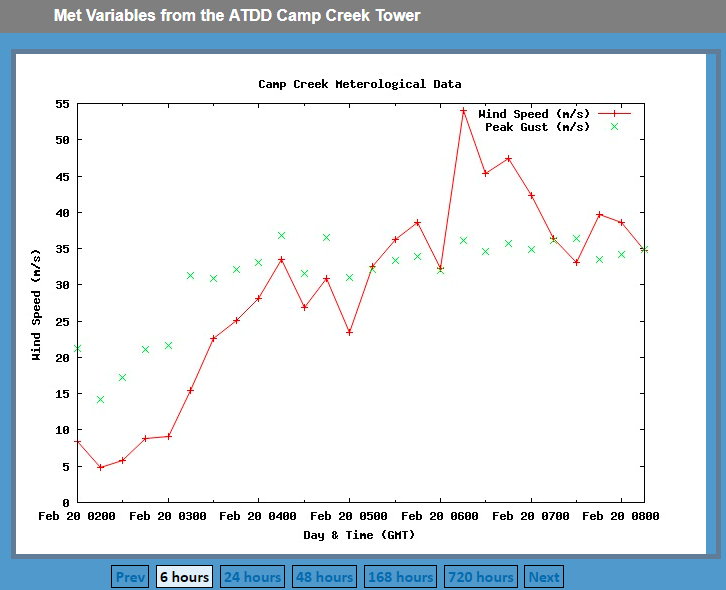
About 30 minutes after posting that, Camp Creek switched to a SE wind and gusted to 53mph. It should continue to increase.
-
Everything still looks on track for a significant mountain wave wind event. It has taken awhile for conditions to become favorable. Even though VWP indicates 40kt SE winds at 4000ft, the cross barrier flow remains blocked. Camp Creek winds haven't really increased yet and aren't currently blowing from a SE direction.
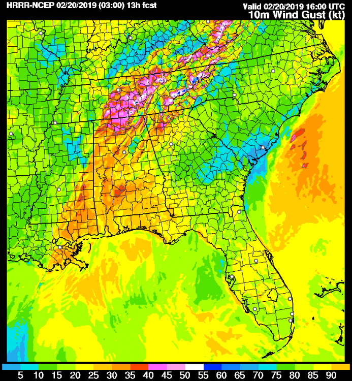
Conditions become much more favorable in the next few hours. HRRR is showing the enhancement right along the mountains and especially in the Camp Creek area by tomorrow morning. That's not the most reliable wind product, but it usually does a good job of showing areas of mountain wave enhancement (even if wind speed isn't accurate). The biggest question for me is how trees will hold up in areas with possible 75+ mph wind gusts and saturated soil.
-
1
-


December/January 2019/20 Winter Speculation Thread
in Tennessee Valley
Posted
That seems to match the graphic I posted.