

Math/Met
-
Posts
235 -
Joined
-
Last visited
Content Type
Profiles
Blogs
Forums
American Weather
Media Demo
Store
Gallery
Posts posted by Math/Met
-
-
Ended up with 5.5 after that last band this afternoon.
-
 5
5
-
-
Heavy snow band moving through Greeneville at the moment. Any melted areas on my road are completely covered again.
-
5
-
-
There was about 4 inches on the picnic table the last time I measured. I'm trying to remember if Greene County ever had a decent mountain wave event (75mph gusts this morning) and then had this much snow in the same day. Interesting day for sure.
-
7
-
-
Good post by John about the DGZ. You can see the effects of the lowering DGZ starting to show up on radar. This allows for some of the low level instability and lift to extend into the DGZ, and helps to aid these bands.
-
5
-
-
A quick update on the mountain wave event with this system. Camp Creek has gusted to around 70mph so far.
-
4
-
 2
2
-
-
Looking at the soundings after the initial band moves through, the 3km NAM soundings are extremely impressive over NE TN on the lingering snow. Snow growth layer drops very low, so terrain induced lift extends into DGZ. Very steep lapse rates extend through the DGZ (SFC CAPE of over 50 in some areas). This all suggests potential convective snow bands and very high snow ratio on the lingering snow by 03z and beyond. Probably 20:1 or better ratios after 03z with some of those snow bands. Those are always some of my favorite things to watch.
-
5
-
4
-
-
30 minutes ago, Stovepipe said:
Those mountain waves though, whatta ya think @Math/Met?
I’m definitely following the mountain waves. It should be a pretty good event. Mountain waves and snow within a 24 hour period... I can’t ask for much better than that.
-
2
-
2
-
-
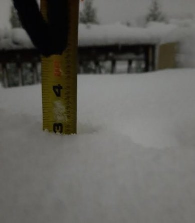
Just measured about 2.5 inches on my back deck in Greene County. By far the heaviest snow of the night is falling at the moment. Over .5 in the last 30 minutes.
Edit: This band is really impressive. Probably right at 3 inches by the time I'm posting this image.
-
6
-
1
-
-
5 hours ago, John1122 said:
There's a possibility of convective snow showers with these disturbances. If you get under one you can see very heavy snow and strong wind for brief periods of time. The GFS advertises some flakes basically statewide.
The NAM soundings are supportive of that for Wednesday night/ Thursday morning. Steep low level lapse rates as 850mb temps drop to below -10C by Thursday morning. Those are always fun if you can get under one.
-
4
-
1
-
-
2 hours ago, MotoWeatherman said:
12z NAM and GFS both really upped the ante for late Wednesday into Thursday. Solid 3+" for most above 4k feet.
I was just looking at that and wondered if you guys were talking about it. The soundings on the NAM are pretty impressive.
-
2
-
-
15 minutes ago, Carvers Gap said:
Agree, if this came in at night...we would have had 4-5" of snow IMBY.
I was thinking the same thing earlier. We had no problems with moisture. Night could have made a significant difference.
-
2
-
-
39 minutes ago, Dsty2001 said:
Spoke with the wife in Greeneville, said snow is starting to stick on roads and temp has dropped below 32
Obviously accumulations vary depending on the surface with these marginal temps and warm ground, but I have nearly an 1 inch on my car. Still coming down at a decent rate, but it’s having a hard time adding to the accumulation. It takes heavy snow rates to really add to the accumulation. The time of day didn’t help here either.
-
1
-
-
The Greeneville airport is down to 32 and reporting .25 visibility.
-
1
-
-
00z Euro has significantly improved for East TN. A step in the right direction.
-
2
-
-
Strictly in terms of precip totals, there was a decent jump in the right direction for East Tn on the 00z UKMET vs 12z.
-
I believe this snowfall output was from a weak inverted trough event. Totals increased at the last minute if I remember correctly.

-
3
-
1
-
-
15 minutes ago, PowellVolz said:
Absolutely. What I was thinking is if the boundary was in the valley, the SE flow over the mountains might down slop before it was lifted back up. I very well could be overthinking this and cramming to much into a small space.
.When it comes to downslope winds in East TN, I would never say never. There are so many possible ways for it to happens. I assume that areas along the mountains of SE TN would have a slightly better chance of that happening, due to the surface winds being SE on the other side of the mountains in that area. I think areas farther to the northeast would be pretty safe from downslope in this situation.
Just to be clear since there is some discussion about this now, this isn't a significant inverted trough. It is very subtle (mainly seen in wind field), but it maybe just enough to help us out a little. Especially in eastern counties. And the northerly flow down the valley could help areas further south with temps, as Jeff mentioned.-
1
-
-
1 hour ago, PowellVolz said:
Just thinking out loud here but with marginal temps the valley needs a possible inverted trough to stay over the mountains. If it lines up in the valley wouldn’t downsloping become a problem?
.In these cases, the inverted trough is induced by the terrain. The air flow is different on either side of the mountains, so you can basically get a "pinching" (not a very technical way of describing it) between the two flows. Neither side has to deal with much downslope because it creates rising air in the low levels. It is a fixed feature because the mountains are a permanent feature. Hope that makes sense.
-
3
-
-
I always try to looks at small details for any event in East TN. Mainly because the terrain can cause things to go unexpectedly wrong or sometimes in our favor. Looking at the NAM, the thing I like about this system is that low level winds over WNC are from a more easterly direction during the start of the system, while winds over the ETN valley are more northerly. This typically happens when we get an inverted trough induced along the mountains, which helps provide some low level lift and often produces more precip than modeled. This current situation is more subtle, but the characteristics are still there. It’s something to watch to see if precip trends upward as we go.
-
5
-
1
-
-
Just got back from Camp Creek. The wind is pretty strong there tonight. I estimate that it was approaching 70mph where I was. I've definitely felt much stronger there in other events, but it was still worth the trip. Fairly consistent gusts.
-
3
-
1
-
-
I’ll move this to the main discussion based on Carvers suggestion. Just wanted to say that the wind event potential has trended a little stronger in my opinion. I thought the MRX discussion was very good regarding this potential.The NAM has slightly shifted the 850mb wind to more of a southerly direction, and that could be just enough to increase the mountain wave enhancement. You don’t really need a southeasterly flow at 850mb because the cross barrier flow is determined at lower levels based on statistical analysis. We often have a southerly or even slightly SW flow over the valley during a mountain wave event. This current event is right on the threshold, so it could go either way in terms of significant MW enhancement. Everything else is favorable. Regardless of MW enhancement, the LLJ is strong enough to potentially cause some tree problems in the mountain and foothills due to saturated ground conditions.
-
5
-
2
-
-
2 hours ago, PowellVolz said:
Mountains yet again are taking a beating this morning. The lack of a sold soil will eventually be a real issue.
.That’s definitely something to watch. There will be some additional strong winds... likely starting tomorrow afternoon. It doesn’t look like a strong wind event at this point, but enough for some concern. I don’t think it would take much to cause some downed trees at this point. If the LLJ trends slightly more southerly (versus SW), then the potential for higher gusts will increase.
-
2
-
2
-
-
19 minutes ago, Carvers Gap said:
Math/Met, what is the timing for this event on Saturday - more late in the day?
It is a prolonged event, but wind gusts should pick up by Saturday morning and continue into the evening. The strongest LLJ winds move in later in the day. Sometimes there's a weakening of winds during the afternoon, and it gets stronger as the sun goes down.
-
2
-
-
17 minutes ago, John1122 said:
I saw that MRX actually started putting social media posts out about it already. I wonder how many places in the United States have such a unique local phenomenon. I know Mount Washington gets extremely high winds but I don't know if that has anything to do with mountain waves.
I know Boulder, CO gets mountain waves too. My former advisor during graduate school wrote a paper on it. Strange coincidence that we both had interests in mountain waves.
-
1
-
 1
1
-

January 2021 Medium/Longterm Pattern Discussion.
in Tennessee Valley
Posted
As currently modeled on the Euro, I have some downslope concerns for parts of East TN (particularly for my area) but that could change over the next couple days depending on the strength and position of the low at 850mb. It's not too bad, just something to keep an eye on. I do like that a bit of an inverted trough is showing up along the mountains leading up to the heaviest precipitation on the Euro. That can help in multiple ways.