

Math/Met
-
Posts
235 -
Joined
-
Last visited
Content Type
Profiles
Blogs
Forums
American Weather
Media Demo
Store
Gallery
Posts posted by Math/Met
-
-
2 hours ago, Carvers Gap said:
@Math/Met, any mountain wave updates. It is howling in west Kingsport BTW. Looks like that wind has worked its way down to the surface here.
There have been a few personal weather stations reporting gusts over 60mph in southern Greene Co earlier today. There is probably bit of a lull right now (typical afternoon lull), but conditions likely become more favorable again tonight and continuing tomorrow. Very strong LLJ with this system. Still think it has potential to create some high end MW gusts in the usual areas.
Unfortunately, I don't think the NOAA tower data for Camp Creek is reliable right now. I have suspected that for a year or two. Seems to be recording wind gusts too low. Because of the tower height and open field at the base of the mountain, it has always recorded higher than other stations in the area. That changed over the past year or two. I kind of confirmed that for myself last event. I went out there, and the tower only record gusts in the 50s while I was there. It felt significantly stronger than 50mph while I was there. Other weather stations recorded 60-70mph around that same time, which seems more in line with my estimates. I have a pretty good idea what a 70mph gust should feel like at this point, so the NOAA tower only recording in the 50s just didn't seem correct. I can't say for certain if it's always unreliable, but I'll probably have to rely on PWS's for wind data in the area.
-
 3
3
-
 4
4
-
-
Several gusts in the 50-65mph range on weather stations in the Camp Creek/Greystone area of Greene County.
-
3
-
-
I'm posting this more from a scientific standpoint because impacts should be minimal. Even though the LLJ isn't strong tonight (only in the 30 to 40kt range at 850mb over the mountains before 12z), conditions on forecast soundings are almost ideal for mountain waves late tonight and tomorrow morning. This would be a turn nothing into something scenario. Just interested to see how windy it can get with relatively weak cross barrier winds. I'll update with obs if it materializes.
Thursday still looks like a major event. The stronger LLJ events like Thursday tend to hit the Smoky Mts pretty good too, in addition to Camp Creek.
-
4
-
-
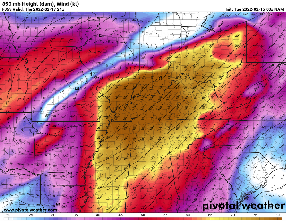
Just wanted to mention that the mountain wave event for Thursday is looking very impressive. The 850mb wind chart is what you'd expect for a damaging wind event in the typical mountain wave areas. There are obviously other factors in these events (850mb wind speed and cross barrier wind direction only explain about 50% of the variability in MW wind gusts at Camp Creek), but this has many characteristics of a very strong wind storm along the mountains and foothills.
-
5
-
2
-
-
I had a nice band of snow move through earlier this evening. Still have very light snow falling at the moment. It was enough to give me a dusting of snow on the grass and cars.
-
7
-
-
Cove Mountain recorded a 74mph gust.
I saw one gust at 64.4mph on a weather station in Camp Creek.
That isn't overly impressive for either location but worth mentioning.
Edit: Just found a 76.7mph gust at Camp Creek on another personal weather station.
-
2
-
1
-
-
Winds have been kept in check so far at CC with the area of rain moving through. That might actually contribute to more favorable conditions for mountain waves (more stable due to precip) this afternoon and evening as the LLJ strengthens and with a break in precip. There seems to be a window today when things could really get going. I think MRX issuing the High Wind Warning was the right call.
-
1
-
-
39 minutes ago, John1122 said:
Does Camp Creek have usually high winds outside of mountain wave events? I often wonder if it's one of the windiest places in the lower 48.
There are definitely breezy days outside of the true mountain wave events...anytime the flow is off the mountains. But it's not constantly windy there. They actually put in a temporary 135ft wind tower over a decade ago to study the potential for wind energy. Nothing ever came from that.
Camp Creek gets all the attention because of the NOAA wind tower, but all of southern Greene County is very windy. That whole area is perfectly positioned at the base of the mountains with the French Broad Valley on the other side helping to funnel the southeasterly winds. South Greene HS is not in the Camp Creek community, and that school has been damaged several times by mountain wave winds. As far southwest in the county as the St. James community has really strong winds too.
-
4
-
-
Winds did pick up again late this afternoon before the stronger winds at 850mb pulled away. The peak gust today was 61mph. I normally wouldn't even bother with mentioning a 61mph gust at Camp Creek, but it's been awhile since there's been a wind event.
Tomorrow is tricky from a forecast standpoint. The LLJ is projected to be much closer to the mountains and strong tomorrow afternoon. The 3km NAM has 850mb winds 65+knots in parts of EAST TN. The problem is the orientation of the flow. It is close to being too much of a SW direction. You don't need 850mb winds to be SE for mountain wave events. In fact, most events have 850mb flow from due south or slightly SSW (winds below mountain tops have to be southeasterly to establish orthogonal flow). However, the 850mb winds tomorrow could be slightly outside of that threshold. It will be very close. The wind energy is certainly there for High Wind Warning type situation, IF the 850mb flow isn't too much from the SW. It is really close as currently modeled.
-
5
-
-
Camp Creek has recorded a gust around 58mph so far. The HRRR suggests it could go a little higher later this afternoon and evening. The flow gets a little stronger over the mountains, and the atmosphere generally becomes more conducive for mountain waves in the evening versus daytime.
-
3
-
2
-
-
It still looks like there will be a prolonged wind event along the mountains and foothills. Winds will begin to pick up tomorrow in the typical areas. The LLJ tomorrow is approaching 65 kts into Middle TN and Kentucky on some models. The flow directly over the mountains is weaker, but still enough to produce strong gusts with the direction of the cross-barrier flow being favorable
Models redevelop and lift the core of the LLJ just far enough north on Thursday to continue the mountain wave threat. Some models have been less aggressive bringing the LLJ that far north, and possibly with a more SW direction. So still a few uncertainties. Either way, this is probably the best mountain wave setup so far this winter(very slow year for mw's). It's not a textbook MW setup, but I think there will still be some decent gusts. Depending on how it develops, I might make a trip to Camp Creek in the next two days.-
5
-
5
-
-
3 hours ago, Daniel Boone said:
Thanks for the uplifting posts Carvers. You made valid points as did Holston. Hopefully, ur right irt the MJO.
There was a time I'd been completely delved n2 and saturated with the current data but, not anymore as my health prevents it. Terrible to seldom feel like doing things you enjoy.
If it weren't for you guy's on here I'd be lost anymore. Those of you that aren't Mets, u r as good as and even better than many. It's a shame most in the Field r not as you all.
This Tennessee Valley forum does a great job with these discussions. I intentionally stay away from the long range stuff personally, because I really don’t think I could add much to what’s already posted here. Obviously Jeff is an expert in long range forecasting, but the rest of you do a great job as well.
I told someone a few days ago. The collective knowledge of all the microclimates and historical data on this subforum is really remarkable too.
-
3
-
-
2 minutes ago, John1122 said:
After getting missed to the west all night it looks like the snow squall in Kentucky is going to miss me to the east by a couple of miles.
These types of bands are great if you get one over your area for a significant amount of time, but they can also be very frustrating to track.
-
1
-
-
2 minutes ago, Reb said:
Huge flakes and heavy snow in Seymour, wow!
I noticed that on radar. Looks great.
-
2
-
-
Got a light dusting out of that band that just moved out of Greeneville.
-
2
-
-
Some of the soundings for tonight are really impressive for this type of setup. Just have to hope you get under some of those bands.
-
4
-
1
-
-
It looks like potential mountain wave event is showing up for next Wednesday/Thursday on the GFS and Euro. I normally wouldn’t mention it this far in advance, but this has been the longest I can ever remember without a legitimate mountain wave event. I know MRX issued a high wind warning at least once this season, but I didn’t consider that to be a true mountain wave event. A lot can change between now and then, but it’s something to watch.
-
6
-
-
Light snow falling in Greeneville.
-
1
-
-
There’s still a subtle inverted trough signature along the mountains on the GFS. Just need a little more of a westward shift, and then that inverted trough could help eastern areas.
-
3
-
-
Really nice band moving through Greene County with larger flakes than earlier. Might be helped by some of the low level instability the models were showing.
-
5
-
-
This current band has easily the heaviest rates of the night for me. Blowing around too.
-
5
-
-
33 minutes ago, Silas Lang said:
Good news for tomorrow. According to MRX:
Outside of the mountains on Monday, low temperatures
should be below normal levels given snow pack, even went below
guidance for the fcst.   Otherwise, expecting a cloudy typical
northwest flow day with light snow showers over the northern plateau
and central/northern valley with afternoon highs struggling to top
the freezing mark north of I40 (and any higher terrain across the
mountains/plateau), with low/mid 30s southward in the valley.  Given
these expecting temperatures, would expect lingering roadways
hazards due to remnant snowpack for much of the area that receives
ample snowfall tonight.
I’m fairly optimistic for some additional snow in the morning in parts of the area. The soundings are encouraging on the 00z 3km NAM. There’s not a lot of moisture to work with, but the northwest flow, combined with 850mb temps dropping to around or below -10C (steepening low level lapse rates), is usually pretty good at squeezing out precipitation in these situations. It obviously varies across the region, but the foothills areas in NE TN can do okay in these setups.
-
2
-
-
It's been a long wait, but Greeneville is finally seeing some decent snow. This band moved in just about 15 minutes ago, but the ground is already turning white.
-
7
-
-
3 minutes ago, ShawnEastTN said:
Something im curious about is the clipper tonight/early morning. In similar situations like this with departing storm with clipper/energy on its heels there is often left over low level moisture from the storm for the clipper/energy to interact with and can make for an over producing event.
Sent from my SM-G965U using Tapatalk
I was just looking at that. The 3km NAM for Northeast TN for tomorrow morning has some nice snow soundings for the lingering snow shower activity associated with the disturbance moving through. The DGZ drops significantly with lift extending into it, and we get some fairly steep low lapse rates to create some low level instability (the sounding I looked at had SFC CAPE of 44, which is pretty good for these situations). With the high ratios, those types of bands can be a lot of fun because they can add up quickly if you are lucky enough to get under one.
-
5
-


Fall/Winter '21-'22 General Obs
in Tennessee Valley
Posted
There's been a 64mph gust so far today in Camp Creek and a 78mph gust on Cove Mountain, so high winds are already verifying in the warning areas. The best opportunity for this mountain wave event is probably after 4:00pm today into early evening, as the LLJ increases over the mountains, 850mb flow backs slightly over WNC, and loss of daytime heating. Thermal profiles aren't ideal, but the amount of wind energy still provides plenty of the potential.