

Math/Met
-
Posts
235 -
Joined
-
Last visited
Content Type
Profiles
Blogs
Forums
American Weather
Media Demo
Store
Gallery
Posts posted by Math/Met
-
-
54 minutes ago, fountainguy97 said:
Here you go. Hard to see but leaves and small debris are ripping past. This is my new record for wind! Previous was 74mph during hurricane Irene in Eastern, NC. Station recorded 83 while I was recording.
Great video. Thanks for sharing. Hopefully you enjoyed your trip.
-
 4
4
-
-
Just now, fountainguy97 said:
I have been to camp creek but not for wind event. I was going to head to the elementary school.
That's the best area. I usually go to the church parking lot that is next to the Camp Creek Memorial. It is next to the school. I like that spot because it gets me away from trees and power lines.
-
5
-
-
15 minutes ago, fountainguy97 said:
Wind is nearing extreme here. Trees down. Power out. I'm heading to camp creek which is gusting toward 90! Only 40min drive.
Keep us posted. Have you been there before?
-
Camp Creek is already getting gusts to nearly 70mph this morning. I actually think this Mountain Wave event is slightly more favorable for Camp Creek than the previous system.
-
4
-
 3
3
-
-
26 minutes ago, Carvers Gap said:
@Math/Met, are we gonna have power tomorrow in E TN? I see where school systems are wisely on delays or closed due to wind potential. Any update on the mountain wave event?
It looks like the mountain wave event is underway. Just noticed a 60mph gust on a weather station in southern Greene Co. I'm actually keeping an eye on areas west of Camp Creek too. On rare occasions, that area can get wind gusts that rival what is experienced at Camp Creek Elementary for a particular event. Unfortunately, the data in that area aren't as reliable. That includes areas like Cedar Creek and St. James. The roof has been blown off the gym at South Greene HS a few times, so these windstorms aren't isolated to the Camp Creek community. This event might actually favor areas just to the west of Camp Creek...but that's just speculation on my part.
Regarding your question, I still believe the effects of the mountain waves will extend away from the foothills in a few areas, and it could cause tree and power issues. It's difficult to pinpoint where. It's common to have 70mph wind gusts in one area while winds remain relatively light just a few miles away.
The LLJ is extremely strong tonight and other parameters are favorable, so it's hard to imagine there won't be some very high gusts recorded.
-
3
-
4
-
-
2 hours ago, Carvers Gap said:
On a non-winter wx note.... @Math/Met , is this a high end event? It looks like it may take a while to burn out....
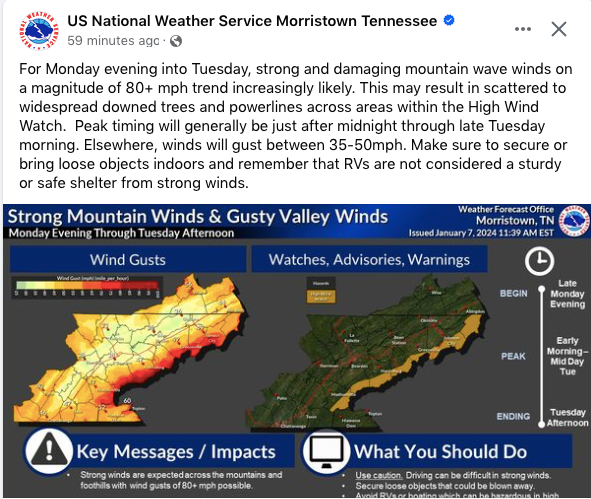
Yes, this could be a very impressive event. I need to give credit to MRX for their great afternoon discussion regarding this. I completely agree with everything they wrote, and I actually agree that the mountain waves might extend a little further away from the mountains than usual.
-
4
-
-
53 minutes ago, fountainguy97 said:
Hrrr goes nuclear with the wind event Tuesday morning. Quite the wind event shaping up. Thankfully rain quickly after.

The potential is definitely there for significant wind event. When HRRR wind gusts look like that, it’s usually a pretty good indication of a high-end event. Even the high-resolution models typically underestimate wind potential with these events, specifically for places like Cove Mountain and Camp Creek. Hopefully we can avoid any major fire issues.
-
5
-
-
The Tweed fire near the Cocke County/Greene County line is showing up pretty good on satellite this evening. Hopefully they can make some progress with that fire in the short term. Wind might become more of an issue for that area by midweek as a southeasterly flow gets established over the mountains. It shouldn't be a significant wind event (the 850mb flow is pretty weak) but it could create some breezy/windy conditions. That area isn't as bad as Camp Creek, but it still gets some significant downslope enhancement with southeasterly flow. You can see signs of the potential enhancement over that specific area on model output.

-
3
-
-
3 hours ago, Jed33 said:
3.47in here so far and still raining. This is the most single day rainfall in my backyard in years. I’d say probably 5 yrs at least!
I was thinking about that earlier today, in terms of where this rainfall total ranks for me. I ended up with just over 6.00 inches today. It caused several flooding issues across Greene County today. Schools are closed tomorrow...it would have been their first full day.
It's definitely one of the largest one-day totals that I can remember. My largest total by far occurred at the same time of year in 2001 (August 3&4). I had over 14.00 inches of rain with that event, but it was actually worse in other areas. I really wish there was a reliable rainfall total from the max area in that 2001 flood. The NWS wrote this a few weeks after the event "An unofficial gauge at Viking Mountain, located approximated 7 miles southwest of the radar-indicated maximum, measured 15.35 inches from Friday evening until Saturday morning". That was probably one of the top 5 most memorable weather events that I've experienced. It was unbelievable how hard it rained for about 4 hours that morning. Today's flooding doesn't compare to that, but it is still a notable event.-
5
-
-
44 minutes ago, Math/Met said:
My rain gauge has 4.60 inches so far today in Greeneville. Still pouring.
Up to 5.53 now.
-
3
-
-
My rain gauge has 4.60 inches so far today in Greeneville. Still pouring.
-
2
-
1
-
-
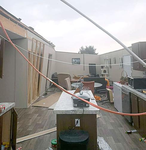
I'm a little late posting this. This is a picture from the Greeneville Sun newspaper. The roof was blown off a double wide mobile home in southern Greene County (Camp Creek area).
-
2
-
-
23 minutes ago, Dsty2001 said:
Sitting in the car waiting for the wife in Greeneville, graupel or something is falling (definitely not 100% rain) but it's 48 here... The heck?
Just noticed that as well.
-
1
-
-
3 hours ago, Math/Met said:
It looks like Camp Creek has gusted to 78mph so far.
Just to follow up on this. I haven't looked to see how bad it was in other areas, but I don't really consider 78mph to be a particularly strong mountain wave event for Camp Creek. This type of system (the evolution and orientation of the LLJ)has underperformed several times at CC in my years of studying them. That's why I was kind of reluctant to go all in on a high end event. Still a decent mountain wave event though.
-
3
-
-
It looks like Camp Creek has gusted to 78mph so far.
-
2
-
1
-
-
Regarding the mountain wave event, the 18z 3km NAM is about as impressive as you will see in regards to the strength and location of the LLJ by tomorrow morning. Greene Co schools are closed tomorrow due to the wind forecast. That's probably a good decision. You don't want buses on the road in southern Greene County with such a high ceiling to this wind event. I still think there are a few potential limiting factors (as I mentioned previously), but there's likely to be a few hours of possibly damaging winds in the favored locations.
-
2
-
1
-
-
1 hour ago, Carvers Gap said:
@Math/Met, what are your thoughts about the upcoming wind event?
There is potential for a significant wind event. Fountainguy's post above illustrates that. It's really a matter of how far north the strongest core of the LLJ gets. Initially, the LLJ builds in from the south and the 850mb flow is more SE across the mountains. In my experience, mountain waves can be slow to establish is this scenario. There's often too much low level lift in this scenario, so parcels don't really oscillate in a wave manner. Once the LLJ gets far enough north, the flow at 850mb veers slightly, to a more traditional direction, and the overall atmospheric profile improves for mountain waves.
The 00z NAM would probably be the most significant outcome. It produces a few hour window of a VERY strong wind event, because it lifts the strongest LLJ winds pretty far north and gets the 70+ kt 850mb winds to the north of the mountains. The 18z Euro is less aggressive with bringing the 70+ kt portion of the LLJ this far north. It would still produce some strong winds but probably not a high end MW event.
So the potential is there for a relatively brief high end event, but my confidence for the severity is lower than normal due to the reasons above. I'll be watching future model runs for how the LLJ evolves.-
3
-
-
1 hour ago, Carvers Gap said:
Just saw a twitter report on WATE...that is a long, long fire line.
Terrible situation. I hope short range models are wrong, because they try to really increase wind gusts near that area over the next few hours. I'm hoping there's some limiting factor that keeps the higher end mountain waves winds from materializing.
-
1
-
-
30 minutes ago, Carvers Gap said:
The fire in Wears Valley is now 1,000 acres with zero containment.
The winds are starting to pick up in that area. Cove Mountain is now up to 74mph.
-
1
-
-
3 hours ago, Holston_River_Rambler said:
Wildfire showing up on radar in Sevier County
Unfortunately, winds will likely increase significantly in that area this evening. This particular setup actually favors that area for very high winds, especially in the Cove Mountain area.
MRX
QuoteA climatologically high-end mountain wave event is occurring this afternoon and into tonight. Gusts 80 to 90 mph still seem likely, and possibly close to the 100 mph range. Outside of the mountains, gusts up to 50 mph are expected in some areas.
-
1 hour ago, Carvers Gap said:
We managed to to get to 3 to 3.5". We would have gotten more had that little area of dry circulation not rotated through last night. It wasn't downslope I don't think. It was location to the track and that little mesoscale circulation of dry air which rotated through. Overall, I thought models did really well with the exception being last minute trends.
I think you are correct about this. It wasn’t downslope in my opinion (at least not in my area). Some models had a hint of a meso- low on this side of the mountains. It wasn’t much, but even a short lull can make a significant difference when rates are high.
-
3
-
-
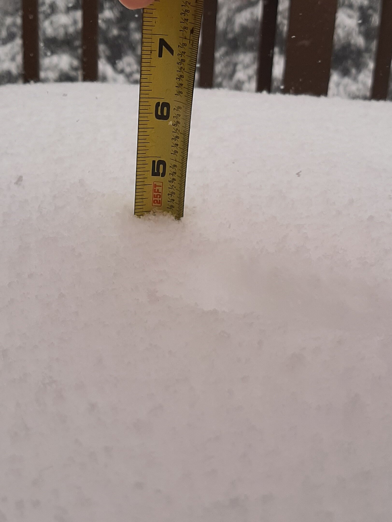
I’ve been fortunate with these snow bands in the last hour. Picked up an inch in the last hour. Up to 4 total. Still snowing very hard at the moment.

-
7
-
-
I saw this on Twitter. I didn't go out there today, so I'm glad someone got some obs from the school since the tower isn't working.
-
4
-
1
-
-
Latest update.
83mph at Cove Mountain
70mph at Camp Creek.
-
2
-
1
-
March/ Spring mid-long range
in Tennessee Valley
Posted
I'm pretty sure the gust of 93mph at Camp Creek overnight was the highest ever recorded at that station...unless I'm forgetting something. I think the previous record was 92mph. I'm certain there were other stronger events (2004 was the strongest I can remember), but there weren't reliable data at that point.