

Spartman
-
Posts
1,202 -
Joined
-
Last visited
Content Type
Profiles
Blogs
Forums
American Weather
Media Demo
Store
Gallery
Posts posted by Spartman
-
-
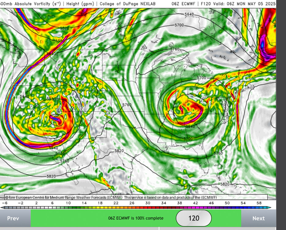
12z Euro (HINT: Most of that falls through next week):

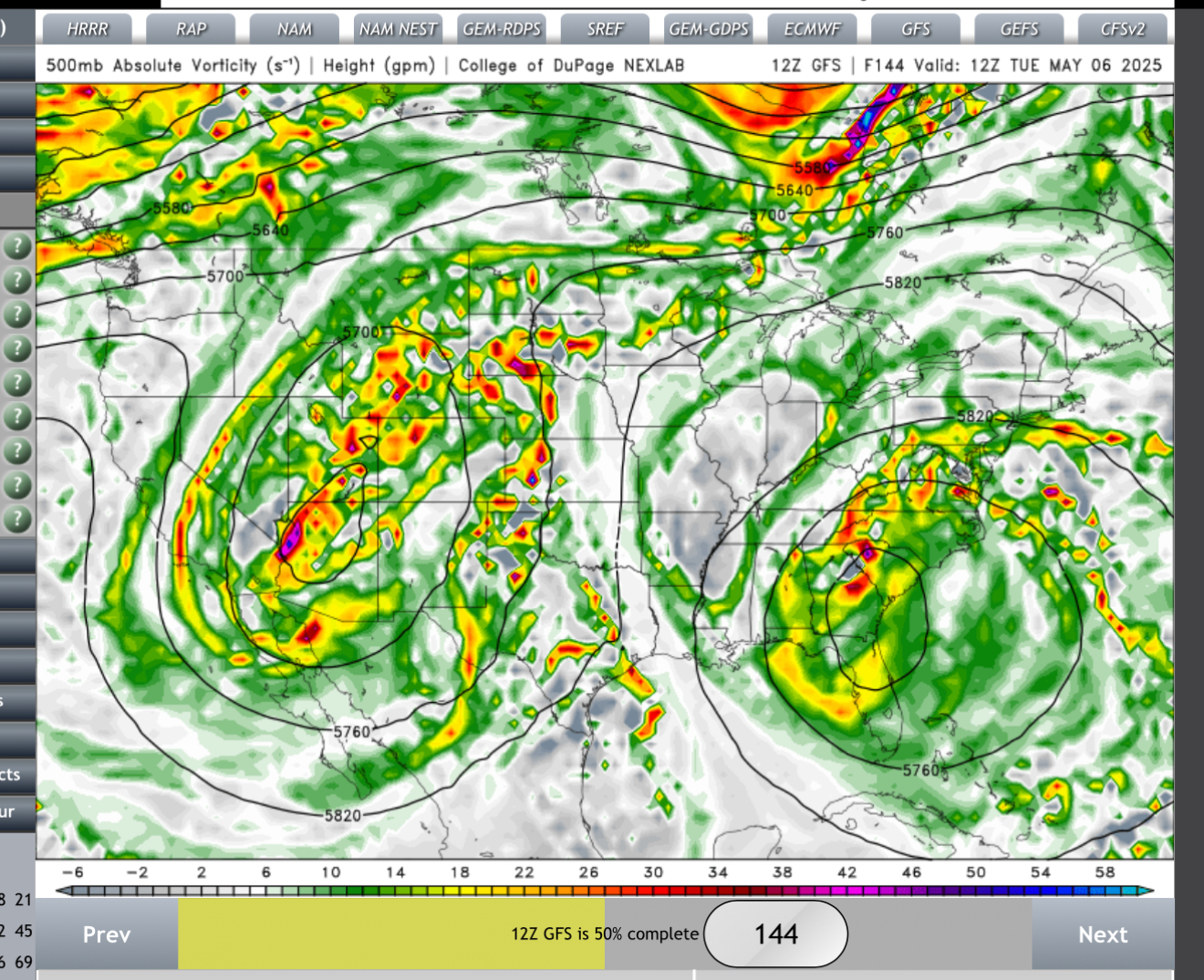
12z GFS:

-
Ben Noll considering the lows in next week's Omega Block as bowling balls
https://x.com/BenNollWeather/status/1917927485087642085 -
14 hours ago, Chicago Storm said:
another nice month on tap.
Another nice month? April was a washout.
Even with a garbage blocking pattern taking place this weekend into next week....

-
Some last minute rain to close out the month with 0.02". Final total for the month is 6.15", still making it the 8th wettest April on record.
Top 10 Wettest Aprils (DAY):
1. 9.20" - 1996
2. 8.72" - 2011
3. 6.95" - 1947
4. 6.78" - 1993
5. 6.52" - 1989
6. 6.32" - 1994
7. 6.19" - 1998
8. 6.15" - 2025
9. 5.98" - 1964
10. 5.87" - 1911Cincinnati had an additional 0.18" to close out the month. Final total for the month is 7.47", making it their 5th wettest April on record.
Top 5 Wettest Aprils (CVG):
1. 13.52" - 2011
2. 9.77" - 1998
3. 8.36" - 1947
4. 8.20" - 1996
5. 7.47" - 2025I had a feeling that was coming all along thanks to the very wet start to the month.
-
12z GFS caving to the recent Euro runs regarding the Omega Block next week

12z Euro has the Omega Block through a good portion of next week followed by another low trying to cut off near Mother's Day weekend, meaning no sustained warmth for at least the 1st half of the month


-
22 minutes ago, MN Transplant said:
The 12z GFS is moving towards the Euro with the cutoff situation. It is wild to see two lows side by side like this.

If only that happened in the winter....

-
With today's storms, now at 6.13" for the month. Currently the 8th wettest April on record for DAY while the 7th wettest April for CVG with 7.29" with only one day left in the month.
-
Still in the COD
-
Can't get any worse, right?
-
17 hours ago, CheeselandSkies said:
Puke. Classic dreaded spring omega block that prevents western troughs from maturing and ejecting properly for
 events.
Already ruining the chance of what would have been a dry weekend for a change this upcoming weekend. Haven't had a dry weekend since late February or a drier-than-normal month since January and might as well wait until at least sometime in the summer to see a dry weekend ever again, knowing how this Spring has been. Hell, I'm ready for 2025 to be over already.

00z Euro still locking in the Omega Block over the weekend, although the Omega Block gets replaced by a potential Rex Block later next week:


00z GFS:

Latest Long Term update from ILN
.LONG TERM /THURSDAY NIGHT THROUGH TUESDAY/...
Showers and thunderstorms will be ongoing at the beginning of the
period, with some strong storms still possible. The more robust
activity will diminish through the evening as upper support lifts
northeast and instability decreases. However, some showers and
thunderstorms may linger with a weakening surface boundary in the
area.

Northern stream short wave will dig southeast Friday into Friday
night. This, along with diurnal heating, will be sufficient to bring
an increased chance of showers and thunderstorms again during the
day. This will continue into Friday night as weak low pressure and a
cold front finally move through.

At this point, guidance diverges as the flow transitions into a
blocky pattern. The GFS and much of its ensemble system are quite
progressive with the trough, not closing it off until reaching the
Maritimes, allowing high pressure to build into the region and
predominate. Meanwhile, the ECMWF and CMC along with many of their
respective ensemble members close off a low near or west of the
Appalachians which then meanders about the region through the rest
of the period. Needless to say, these two scenarios would result in
a substantial difference in sensible weather. The NBM and the lag
built into that is still pretty optimistic. But with the trends seen
in the ECE and GEPS, have begun to trend the forecast to more clouds
and low PoP chances.
IND office caving to the ILN about the blocking pattern
.LONG TERM (Thursday through Tuesday)...
Issued at 325 AM EDT Wed Apr 30 2025

Unsettled conditions continue with additional opportunities for
showers and thunderstorms as we wrap up the work week with a cold front
moving across the Thursday night followed by a trailing upper level
low and associated surface trough on Friday. The warm front
should be fully north of the forecast area by Thursday morning as
low pressure lifts into north central Illinois. High pressure will
build in for the weekend with an amplified and blocky upper level
pattern developing across the country by early next week. There
remains the possibility that the upper trough passing through the
Ohio Valley during the first part of the weekend closes off into a
low to our east into early next week. This would delay the
arrival of ridging and warmer air by a few days and could cause a
wet and unsettled pattern to linger but confidence is low in this
solution coming to pass. The more consistent idea remains that
ridging aloft and at the surface will become the dominant features
across the region and bring a return to warm and dry weather by
early next week.
TWC/Wunderground is already hugging the Euro regarding this weekend into early next week.

BAM bringing up the blocking pattern, as well
https://x.com/bam_weather/status/1917255041062260887
Wonder how soon until JB starts bringing up next week's blocking pattern
-
 1
1
-
-
ILN wants to talk about a blocking pattern developing this weekend into next week
.LONG TERM /WEDNESDAY NIGHT THROUGH MONDAY/...
A robust short wave moving out of the Ozarks on Thursday will
deamplify as it lifts up the Ohio Valley on Thursday night. At the
surface, a warm front will lift across the region Wednesday night
and there could be some showers and thunderstorms associated with
that. Potential for showers and thunderstorms in the warm sector
will increase with the combination of diurnal heating and the
approach of upper support. Activity will wane somewhat as the short
wave lifts away from the area later Thursday night. The short wave
will take a surface low west and north of the region, but a trailing
cold front will slide into the forecast area Thursday night.

The front will not make it all of the way through the area until
Friday and possibly Friday night when a stronger push comes from a
northern stream trough digging into the region. Showers and some
thunderstorms will continue until this trough passes east of the
area.

With the passage of this trough, the mid levels transition into a
high amplitude, blocky pattern. A closed low will develop out of the
base of the trough that moves through, but there is some potential
that this low then retrogrades back into the region early next week.
With quite a wide range of solutions on where a closed low will
occur, have stayed pretty close to the NBM for now keeping the
region dry.

Temperatures will remain above normal through Friday and then drop
below normal over the weekend. If the closed low stays east of the
area, then temperatures will rebound early next week.
06z GFS:


00z Euro:


-
Suicide weather yesterday, it returns tomorrow. TWC/Wunderground now says it might as well include some rain if they have maintained overcast skies for tomorrow over the past several days. So much for the 1st dry weekend of Spring 2025.


Normally we would have at least one dry weekend or two every Spring, but I feel that this is just not going to be our year. Even wet springs like 2011 had some dry weekends.
The last time it rained literally EVERY SINGLE WEEKEND the entire Spring was in 2019.
-
-
-
On 4/2/2025 at 1:29 PM, madwx said:
cool/cold shot early next week. Then things turn mild around the weekend of the 12th.
Probably going to be a head fake. Doesn't look like any sustained warmth for the remainder of the month.


-
7 hours ago, RogueWaves said:
More BS backwards spring on deck here tomorrow
Below normal temperatures every single day for this upcoming week through Saturday.
TonightA chance of rain and snow showers before 11pm, then a slight chance of snow showers between 11pm and midnight. Cloudy, then gradually becoming partly cloudy, with a low around 33. Northeast wind 5 to 11 mph. Chance of precipitation is 50%. Little or no snow accumulation expected.MondayIncreasing clouds, with a high near 55. Light west wind increasing to 11 to 16 mph in the morning.Monday NightMostly clear, with a low around 24. Northwest wind 13 to 16 mph, with gusts as high as 26 mph.TuesdaySunny, with a high near 43. Northwest wind around 11 mph.Tuesday NightMostly clear, with a low around 27. Northwest wind around 6 mph becoming calm in the evening.WednesdayA chance of showers after 2pm. Partly sunny, with a high near 47. Chance of precipitation is 40%. New precipitation amounts of less than a tenth of an inch possible.Wednesday NightShowers, mainly after 2am. Low around 41. Chance of precipitation is 80%.ThursdayShowers. High near 56. Chance of precipitation is 80%.Thursday NightA chance of showers. Mostly cloudy, with a low around 37. Chance of precipitation is 30%.FridayMostly sunny, with a high near 52.Friday NightPartly cloudy, with a low around 34.SaturdaySunny, with a high near 57.Saturday NightMostly clear, with a low around 36.SundayMostly sunny, with a high near 65.
Yesterday's soaker:000 SXUS71 KILN 060536 RERDAY RECORD EVENT REPORT NATIONAL WEATHER SERVICE WILMINGTON OH 0134 AM EDT SUN APR 06 2025 ...RECORD DAILY MAXIMUM RAINFALL SET AT DAYTON OH... A RECORD RAINFALL OF 1.65 INCHES WAS SET AT DAYTON OH (KDAY) ON SATURDAY, APRIL 5. THIS BREAKS THE OLD DAILY RECORD FOR THE SITE OF 1.37 INCHES SET IN 1936. $$-
 1
1
-
-
On 4/3/2025 at 11:13 AM, Powerball said:
Let's just say I'll rather deal with Summers in Texas over the Winters downwind of the Great Lakes.
EDIT: And days like the ones we're expecting through the weekend (temps stuck in the 50s with nothing but stratocumulus and light stratiform rain/drizzle) only reaffirms how much I would hate having to deal with several months of it.
Definitely going to be a long crappy 1st weekend of April, for sure
-
1
-
-
000
SXUS71 KILN 030642
RERDAY

RECORD EVENT REPORT
NATIONAL WEATHER SERVICE WILMINGTON OH
0239 AM EDT THU APR 03 2025

...RECORD HIGH TEMPERATURE SET AT DAYTON OH...

A RECORD HIGH TEMPERATURE OF 81 DEGREES WAS SET AT DAYTON OH
YESTERDAY.
THIS TIES THE OLD RECORD OF 81 DEGREES SET IN 1963.


$$
First 80-degree of the year yesterday
-
2
-
-
33 minutes ago, CheeselandSkies said:
Annnnd the clouds have thickened up again. Vis sat looks like we should be almost clear, but looking out my window tells a different story.
-
06z NAM not as wet as the 00z Euro or 06z GFS:

If only the upcoming system was a winter storm instead.....

-
BAM still on board with an April 2011 redux over the next several days
https://x.com/bam_weather/status/1907055895877652665
-
-
2 hours ago, KeenerWx said:
Looking like this might be a dud locally, with better chances south & east.
Models and even NBM had the high rainfall amounts locked in for the past several days, if not at least a week.
-
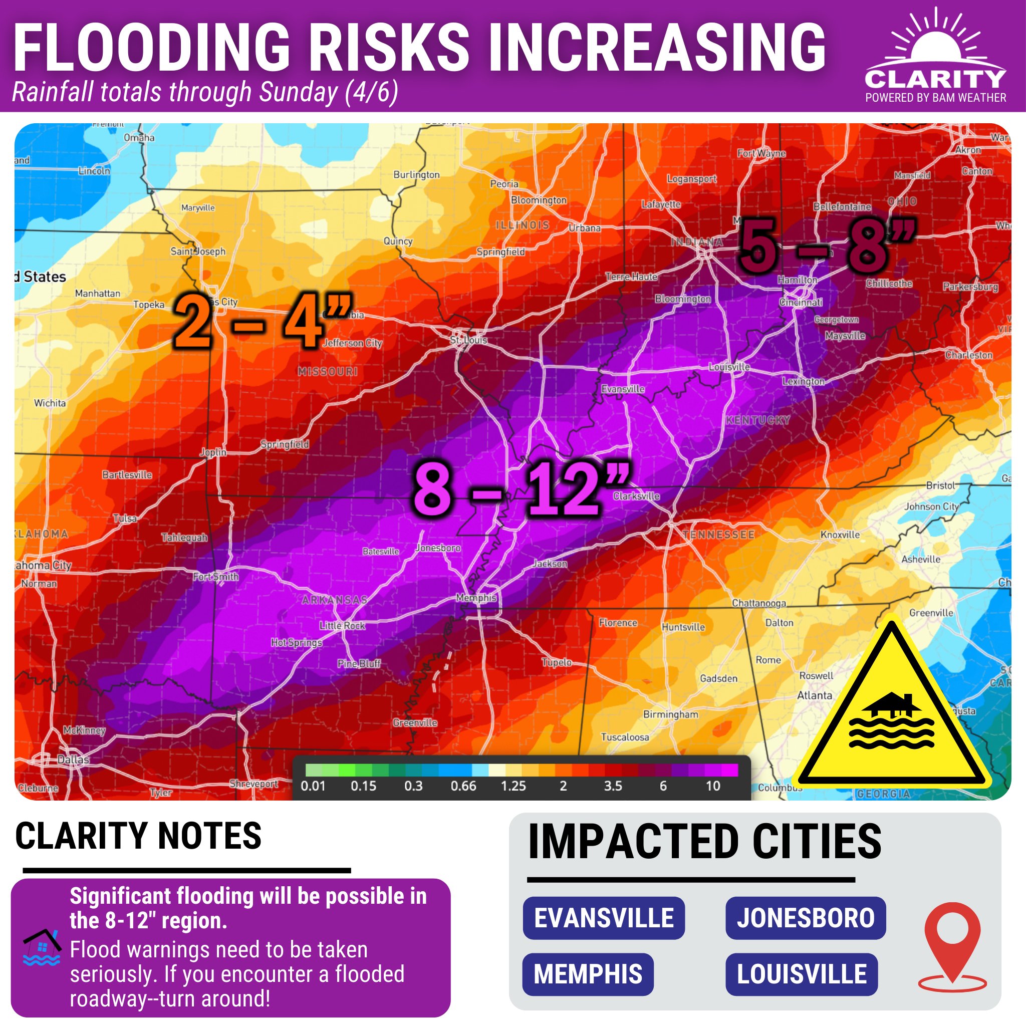
April kicks off on a chilly note on April Fool's Day, but we're going to a warm, but very wet stretch the day after that will last through the first weekend of the month. A stretch so wet that many places could risk making it to the top 10 wettest Aprils ever during the first days of the month right before we start dealing with the effects of the March SSW the week after. Models have actually had such a wet start to the month zeroed in for the past several days.
GFS 18z:

Euro 12z:

https://x.com/webberweather/status/1904243702932918584


-
1
-
 1
1
-


Spring 2025 Med/Long Range Discussion
in Tennessee Valley
Posted
12z Euro:

12z GFS:
