

Spartman
-
Posts
1,202 -
Joined
-
Last visited
Content Type
Profiles
Blogs
Forums
American Weather
Media Demo
Store
Gallery
Posts posted by Spartman
-
-
5 hours ago, snowman19 said:
I have a feeling this is going to be a very wet and humid summerA very wet 2025 altogether, perhaps
-
1 hour ago, dewydews said:
Good, now are you going to stop crying like a little bitch? Everyone's tired of your nonsense, so shut the fuck up.
YOU SHUT UP!

Well, excuse me if I ever posted on this forum in the first place! I DIDN'T COME HERE TO BE INSULTED!
 Hope you get banned for this kind of comment, you troll. This is not the place for these type of insults.

-
 2
2
-
 3
3
-
 1
1
-
-
-
9 hours ago, so_whats_happening said:
Since this thread turned into a semi Climate thread warmer oceans and atmosphere allow for more water vapor leading to hefty rain events. Feast or famine seems to be the name of the game as of now with weather patterns.
Just hope we have not turned on the faucet like we did in summer of 2018.
We may have already turned on the faucet. Same thing happened in 2011. Several wet months that year, especially the Spring and Fall. One of the wettest years ever for many, followed by the dreaded Winter 2011-12.
-
1
-
-
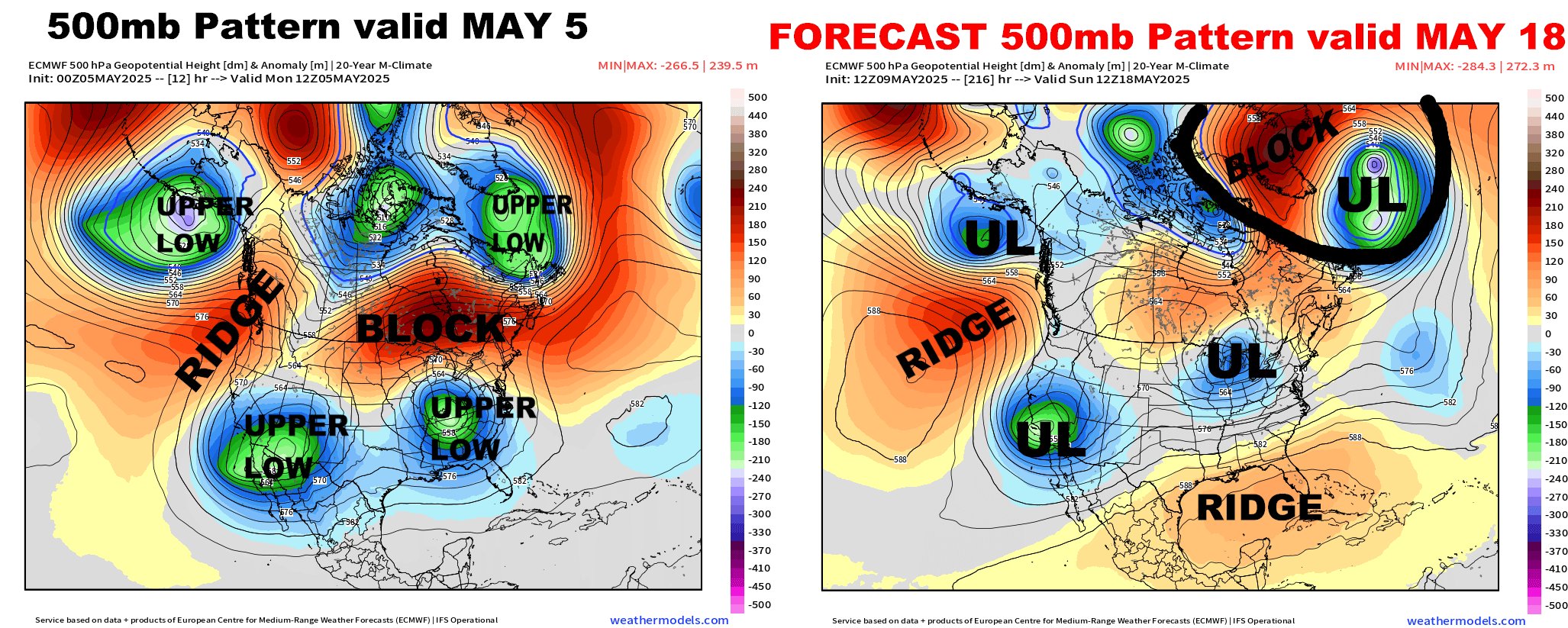
On 5/14/2025 at 12:44 PM, LibertyBell said:
these weird stuck ULL are also responsible for our rainy spring, I'm completely done with them.
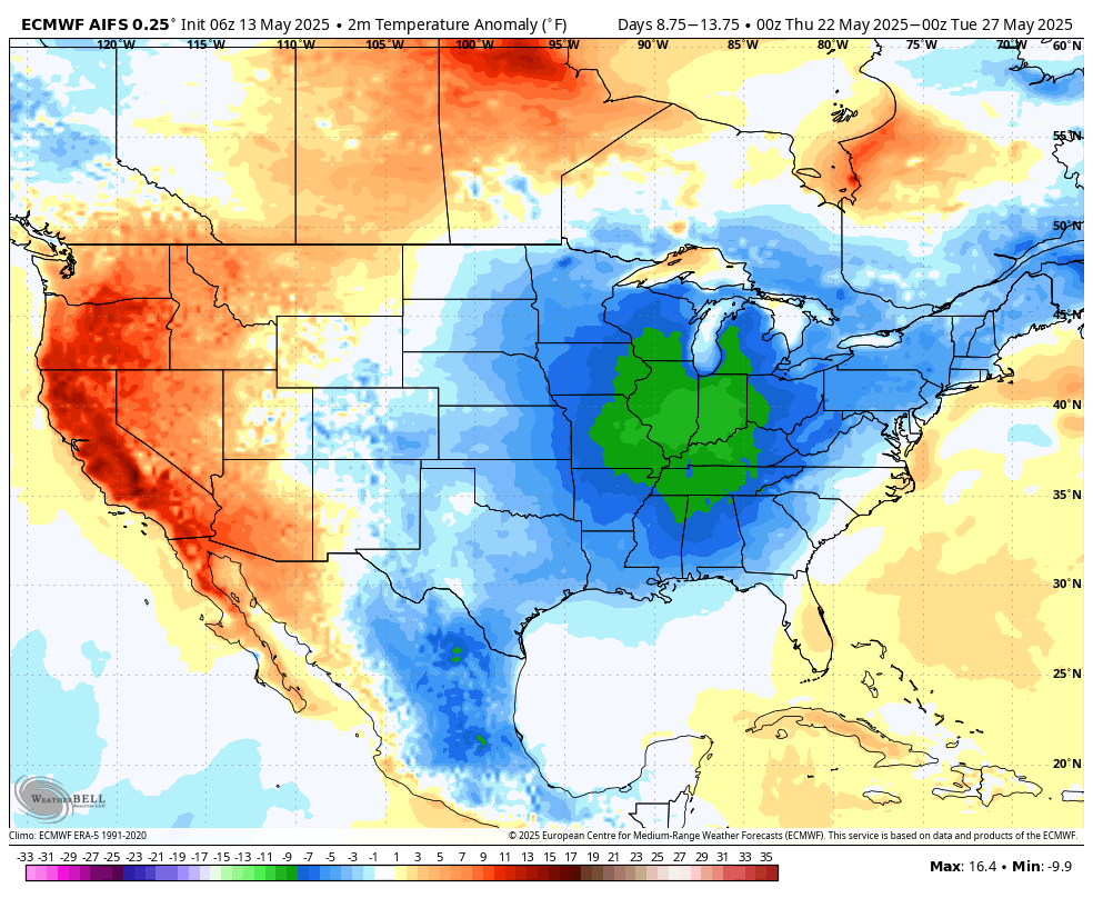
Feels like we've been cheated out a Spring this year. Too many cutoff lows this month, for sure. September 2011 had something similar when two cutoff lows, combined, dominated over half the days of the month resulting in a record wet September.
Looks like it may very continue into next month.

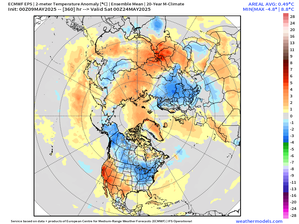
The end of the 00z Euro run:

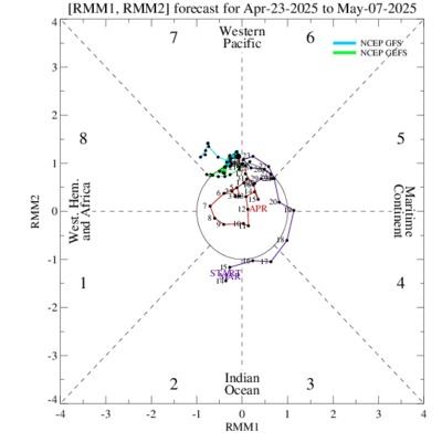
Also, the MJO's been stuck in the Circle of Death phase all month.

According to JB, the last time MJO's stuck in the Circle of Death the entire month of May was back in May 2012, though that was followed by a very hot summer.
https://x.com/BigJoeBastardi/status/1922477577555366262-
1
-
-
18 hours ago, Powerball said:
Definitely wouldn't be fine if I lived in Ohio...
Wouldn't be fine when JB officially starts talking about Memorial Day weekend, as of this morning.
https://x.com/BigJoeBastardi/status/1922282897592971662
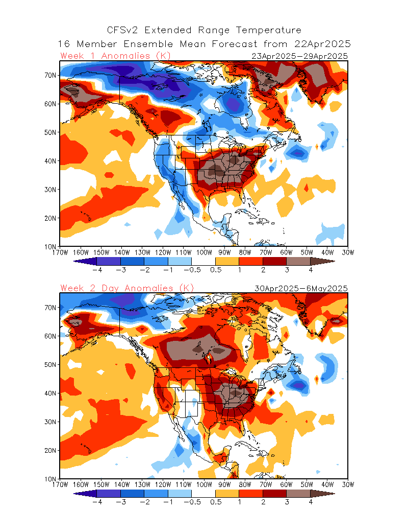
CFS v2 and CPC agree.
CFS v2:
CPC:

There are a lot of times that cold Memorial Day weekends have been followed by cooler than normal summers like 2003, 1996, or 1992.
Also, the NAO and PNA will be negative by that time while the AO is near neutral.
-
5 hours ago, WmsptWx said:
I think this is going to be the story until La Nina takes back over in fall. Cold summer coming.
This year is shot. Ready for 2026 already.
-
3 hours ago, Powerball said:
^^^Fine with me!!!
Not fine according to 18z GFS.
Thursday May 22 (some spots stuck in the mid to upper 40s):
The day before Memorial Day (stuck in the low to mid 50s):

-
6-10 day:


8-14 day: Just in time for Memorial Day weekend :sarcasm:


-
 1
1
-
-
8-14 day:

Lookin' wet

12z Euro:

18z GFS:
Judah bringing up Greenland Blocking leading to a chilly 4th week of May as the large disruption by March's polar vortex comes to an end.
https://x.com/judah47/status/1920869876068970801
Another Omega Block shaping up the week before Memorial Day weekend?
https://x.com/WxRiskGrains/status/1921357712945734046 -
2 hours ago, Jackstraw said:
Yeah, I saw an 87 out in weenie land on my P&C. Not ready, never ready until after Memorial day, then bring it because its only gonna last 4 months at most by then

Speaking of Memorial Day, the 18z GFS run has a bit of an ugly look for this Memorial Day weekend with a potential cutoff low and being stuck in the 50s
Saturday May 24th:

Sunday May 25th:


-
-
21 hours ago, Baum said:
"BY EARLY NEXT WEEK THERE IS
GREATER SPREAD IN GUIDANCE REGARDING WHERE THAT UPPER LOW WILL
END UP. "LOT Forecasters:

12z Euro:

12z GFS:

12z Canadian:

Both 12z GFS and Euro runs are hinting a cutoff low and blocking pattern just before Memorial Day weekend. Quite trainwrecky, for sure.

12z GFS:


12z Euro:

This month really needs a Reset button.
-
 1
1
-
-
000
SXUS71 KILN 070651
RERDAY

RECORD EVENT REPORT
NATIONAL WEATHER SERVICE WILMINGTON OH
251 AM EDT WED MAY 07 2025

...RECORD DAILY MAXIMUM RAINFALL SET AT DAYTON OH...

A RECORD RAINFALL OF 1.16 INCHES WAS SET AT DAYTON OH YESTERDAY,
TUESDAY, MAY 6, 2025. THIS BREAKS THE OLD DAILY SITE RECORD OF 0.91
INCHES SET IN 1971.


$$
Only in the middle of the 1st week of May, but already have 3" of rain for the month already. No way May's going to be drier than normal by the time the month is over. Keep the stretch of wetter-than-normal months coming over the next several months, especially with some of the near-biblical rains, and we can forget having a summer this year.

-
5 hours ago, Powerball said:
That extremly late-in-the-season PV split during early April kind of helped to reset the pattern from what was looking to be a torchy Spring (after the unusually warm/dry March).
That said, there are early indications of a transition to more heat/ridging by mid-month.
Wouldn't count on it. Models hinting another cutoff low for next week.
12z GFS:

12z Canadian:

It gets worse on the 12z GFS run that it keeps us pretty much in Cutoff Land for a good portion of the month, especially about a week after next.

-
Better be just a blip

12z GFS regarding May 18th, highs stuck in the 40s:


-
1
-
-
6 hours ago, snowman19 said:
I’m starting to wonder if we see a weak La Niña develop. I’ve been saying cold-neutral and I still think that’s the favored outcome but the door seems to be opening for a possible weak Nina to develop this summer/fall. It appears a strong -IOD is taking shape, that, along with a continued -PDO, -PMM and the surface/subsurface/trade wind/SOI trends are seemingly opening the door for a possible weak Niña
Might as well

-
Don't be pushing for a repeat of this past weekend now, NWS ILN!
From NWS ILN's recent Long TermEnsemble guidance seems to be in fairly good agreement showing an influx of very dry air from the N into the daytime Friday, even with the details regarding the digging S/W into the ern Great Lakes and NE CONUS still somewhat uncertain. Should this feature dig to the SW a bit more into the ern OH Vly, some of the driest air may be shunted a bit more to the W of the local area into Saturday, but latest guidance still maintains a dry fcst locally during this period. This being said, the ensemble data points toward a cutoff low that develops further to the W closer to the ILN FA Friday into Saturday, which would likely mean daytime temps that may be quite a bit cooler than the blended fcst currently suggests. Certainly the trends portend that we may have another cutoff low to contend with immediately to our E into Saturday and the interaction between the digging S/W NE CONUS trof and the lumbering broad cutoff low in the S mid MS Rvr Vly will be watched closely for adjustments to the fcst. The exact evolution of this pattern into next weekend still has some uncertainties at these time ranges given the weak flow and interaction between various relatively weak systems. But for now, near to slightly below normal temperatures and drier conditions are favored mid to late week before a gradual warming trend evolves by late next weekend into early next week. -
2 hours ago, madwx said:
thinking things will trend drier and warmer over the next 10 days but definitely some cool days mixed in, especially this week. looking at a change to SW flow and more active conditions around the 15th which should last through the end of the month (this is tied to indian ocean convection which climatologically flares up around this time - hence late May being a classic tornado stretch for the plains)
Mainly cool days for the upcoming week for sure
MondayA chance of showers before 1pm, then a chance of showers and thunderstorms between 1pm and 2pm, then showers likely and possibly a thunderstorm after 2pm. Mostly cloudy, with a high near 62. Southeast wind around 8 mph. Chance of precipitation is 60%. New rainfall amounts of less than a tenth of an inch, except higher amounts possible in thunderstorms.Monday NightA chance of showers and thunderstorms. Mostly cloudy, with a low around 48. Southwest wind around 6 mph. Chance of precipitation is 40%. New precipitation amounts between a tenth and quarter of an inch, except higher amounts possible in thunderstorms.TuesdayA chance of showers, with thunderstorms also possible after 2pm. Mostly cloudy, with a high near 66. Southwest wind 6 to 10 mph. Chance of precipitation is 50%. New rainfall amounts between a tenth and quarter of an inch, except higher amounts possible in thunderstorms.Tuesday NightPartly cloudy, with a low around 50.WednesdayPartly sunny, with a high near 74.Wednesday NightMostly cloudy, with a low around 52.ThursdayMostly sunny, with a high near 69.Thursday NightMostly clear, with a low around 44.FridaySunny, with a high near 70.Friday NightPartly cloudy, with a low around 47.SaturdayMostly sunny, with a high near 74.Saturday NightPartly cloudy, with a low around 52.SundayMostly sunny, with a high near 77. -
35 minutes ago, IronTy said:
GFS says no.
Euro says just barely.

12z GFS keeps an upper low pretty much near to sea while 12z Euro has an upper low centered on Pennsylvania


-
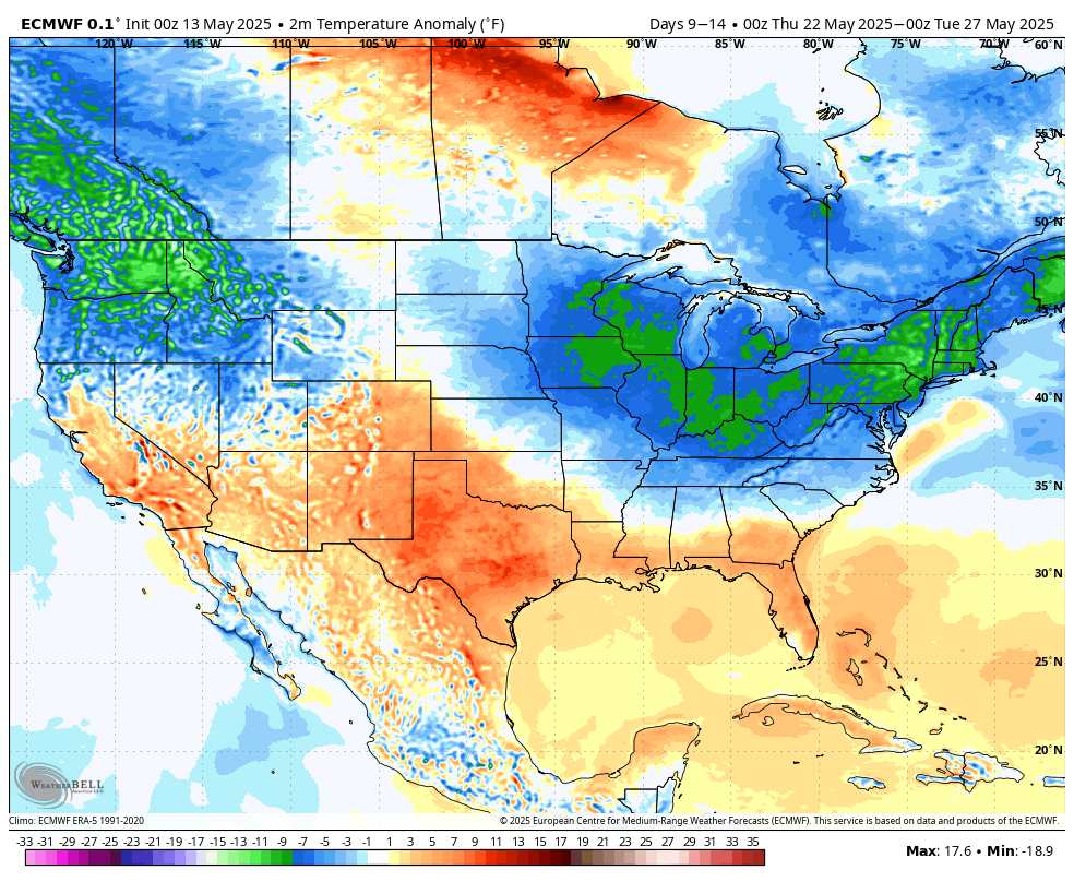
Not good if you're looking for sustained warmth in the foreseeable future

-


NAO, PNA, and AO all going negative by mid-month:

MJO currently in Phase 8, but goes back to COD very soon
-
19 hours ago, Baum said:
From LOT AFD Highlights yesterday at this time:
ABOVE NORMAL TEMPERATURES AND DRY CONDITIONS OVER THE WEEKEND AND INTO EARLY NEXT WEEK.
Ugly miss and turn of events.

Yep, weekend's gonna suck for sure.
-
1
-
-
Cutoff low associated with the Omega Block this weekend into next week? Definitely.
But back-to-back cutoff lows late next week? That's got to be an insult to injury. Time to start thinking about writing off the month already?IND:
.LONG TERM (Saturday through Thursday)...
Issued at 255 AM EDT Fri May 2 2025

The long term period will be characterized by a somewhat stagnant
pattern featuring a couple of cutoff upper level low pressure
centers, which will impact the area over the weekend into early next
week, with the second following mid to late week.

This will lead to seasonably cool and dreary conditions through the
weekend into Monday, with near constant chances for showers and
occasionally a few thunderstorms. As the first low departs, a break
in rain chances is expected Monday night into Tuesday night before
the threat for showers returns Wednesday onward.

Differences in model handling of the blocky pattern and particularly
the second low pressure system leads to lower confidence and thus
lower PoPs later in the forecast period.

Temperatures will moderate mid to late week as the mid to upper
level cold pool associated with the first low departs, though as
with precipitation chances, uncertainty is higher in this regard, as
some guidance shows a connection to a longwave trough developing
with the second low, which could allow another intrusion of cooler
air into the region.

Nonetheless, the story of the next week or so will be temperatures
near to below normal and frequently damp and dreary conditions.
ILN:
.LONG TERM /SATURDAY NIGHT THROUGH THURSDAY/...
Surface wave will slowly exit to the east Saturday night, taking
widespread showers with it. However, behind the wave, a cut-off upper
level low will remain wobbling over the Ohio Valley Sunday through
Tuesday. Cool air aloft associated with the cut-off low will bring
mostly cloudy skies and scattered showers during the day along with
below normal temperatures.

The low will slowly shift off to the east into mid-week. Guidance is
understandably uncertain with what follows in this blocky pattern.
One potential solution is another cut-off low to replace the first
(i.e., cool and damp). However, differences in placement of this
second upper low could lead to different sensible weather, so will
keep chance PoPs and near-normal temperatures until there is a
little more agreement in the guidance.


May 2025 General Discussion
in Lakes/Ohio Valley
Posted
Probably picking the wrong time for that in the Elwood area.