

Spartman
-
Posts
1,214 -
Joined
-
Last visited
Content Type
Profiles
Blogs
Forums
American Weather
Media Demo
Store
Gallery
Posts posted by Spartman
-
-
-
5 hours ago, Maxim said:
Aren’t you the one who cries like a petulant child any time Dayton fails to reach 90° during the summer? Quite ironic coming from a clown such as yourself, whose perspective holds no weight to me (or even anyone with half a brain). Almost seems like projection on your part, it’s strange. Regardless, you come off as the village idiot, and somehow you seem proud of it.
Village idiot? Village idiot?!
I have a right to reply or post on this forum. If you don't like our posts, why are you here anyway?
Commie!

-
 1
1
-
-
Got 2.65" of rain this morning. Now at 8.63" for the month, currently the 3rd wettest May on record. The record is 9.05" in May 1995. With some more rain on the way through the upcoming week, might as well just go for broke.
Top 5 Wettest Mays (DAY):
1. 9.05" - 1995
2. 9.01" - 1938
3. 8.63" - 2026 (as of 5/23)
4. 8.55" - 1989
5. 8.40" - 1990-
 1
1
-
-
Garbage pattern over the next week as we'll get to have an Omega Block to close out the month.
https://weather.com/2026/05/22/forecast/national/omega-block-pattern-flood-threat-temperature-flip
18z GFS:
12z Euro:
-
 1
1
-
-
NWS ILX in Lincoln, IL bringing up a blocking pattern taking place for Memorial Day weekend heading into next week.
Heading into next week, global deterministic models suggest the development of a Rex block over the Plains. The progression of the associated upper low will ultimately dictate rain and storm potential through early next week. Current indications suggest that areas south of I-72 are best positioned for rainfall as the low portion of the block pivots up the Mississippi Valley while the high-pressure side loiters over the Corn Belt. There is stronger model agreement regarding temperatures, with mid-to- upper 80s heat forecast to return by the middle of next week. -
On 1/27/2026 at 3:36 PM, Brian D said:
Memorial Day is showing a threat of shwrs/stms. Possible some energy from the W may sneak along the boundary. But the pattern for late May actually looks rather cool, so it may get shunted south if it does move out. The weekend in general looks bookended with frontal activity.
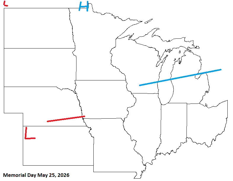
The long Memorial Day weekend this year is looking like a washout, for sure.
-
3 hours ago, Brian D said:
Looks like for the rest of May, the areas that really need the precip should see some improvement.


Looking biblical. This is a repeat of May 2003.
-
6 hours ago, A-L-E-K said:
my guy maxim woke up and chose violence
back half of the month showing some promise, need that 540 line up around the hudson bay where it belongs
Nope, Maxim woke up and chose trolling
-
1
-
-
CPC sticks a fork in May this year

-
1
-
-
-
5.96" of precipitation for the month, just 0.04" shy of the 10th wettest March on record of 6" back in 1907.
-
000 SXUS71 KILN 230545 RERDAY RECORD EVENT REPORT NATIONAL WEATHER SERVICE WILMINGTON OH 145 AM EDT MON MAR 23 2026 ...RECORD HIGH TEMPERATURE SET AT DAYTON OH... A RECORD HIGH TEMPERATURE OF 86 DEGREES WAS SET AT DAYTON OH YESTERDAY. THIS BREAKS THE OLD RECORD OF 84 DEGREES SET IN 1907. $$ -
Not our month for a lot of dry weather, according to BAM

https://x.com/bam_weather/status/2027565955266572494 -
Warm-ups coming during the month, but get ready to be cheated out of them with endless rain. The upcoming week is going to suck and will be a total washout.

-
Signs of a record wet March and perhaps the whole Spring?
12z GFS:
12z Euro:

-
3
-
 1
1
-
-
Looking like a garbage pattern for the final week of the month
-
2 hours ago, Malacka11 said:
Yeah basically looks like the rest of the season can be written off at this point. First torch is already locked in and after that I'd rather just save the ol' climo luck points for next season
Repeat of February 2018 incoming
-
 1
1
-
-
4 hours ago, TimChgo9 said:
Cloudy, cold, but today we get out of the deep freeze with temps a 31 for a high.
Going to be that kind of a week, for sure.
-
31 minutes ago, michsnowfreak said:
Blue sky snowblind day to start February. After a low of 2, the high of 27 felt almost mild. It was the first time we hit 20° in 10 days.
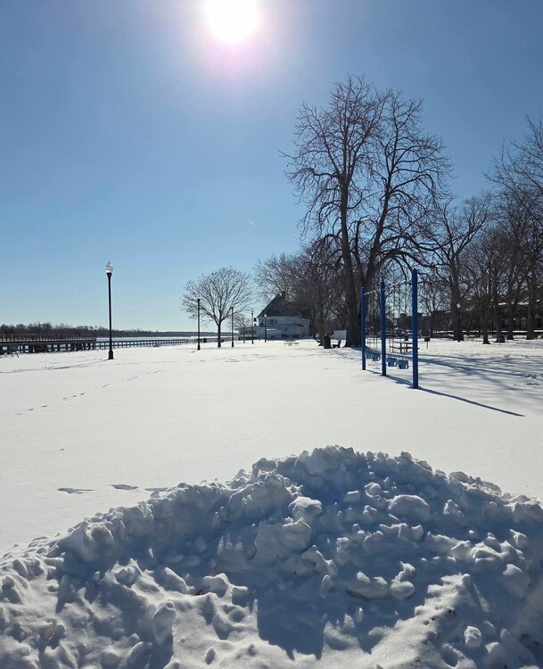
Same here. A clear day today was a great way to start the month before it gets all downhill again tomorrow.
-
1
-
-
-
-
The final month of Meteorological Winter is near. Plenty of cold, but not much snow or sun over the next week.

-
At 0.1" of snow for this month right now. Currently tied for 2nd least snowiest January with 1989.
-
Today's CFSv2 weeklies hold off any cold until the beginning of February


May 2026 General Discussion
in Lakes/Ohio Valley
Posted
Wettest May on record with 10.31" for the month (previously 9.05" set in 1995). Washout of a month. Good riddance.