

Spartman
-
Posts
1,202 -
Joined
-
Last visited
Content Type
Profiles
Blogs
Forums
American Weather
Media Demo
Store
Gallery
Posts posted by Spartman
-
-
Another of meteorological summer, another month of relentless rain for 2025 (especially some days of biblical rainfall)

-
On 6/29/2025 at 10:05 PM, cyclone77 said:
Not even close.
Finished the month with 6.21" of rain for this June, just 0.45" away from reaching the top 10 wettest Junes on record.
Top 10 Wettest Junes (DAY)
1. 10.59" - 1958
2. 9.54" - 1980
3. 9.09" - 1903
4. 7.88" - 2015
5. 7.59" - 1924
6. 7.43" - 2017
7. 7.32" - 1902
8. 7.22" - 1932
9. 7.13" - 1928
10. 6.66" - 1986 -
After 7 straight days of 90s, the heat wave is over
-
It begins today for some. Got the first 90 of the year here.
-
First 90 of the year today. Cincinnati and Columbus didn't, though the latter got 89'd.
-
4 hours ago, Jackstraw said:
It's starting to get biblical here. Another 2.5in last night. I have serious flood issues now. Creeks over its banks. Waters about 6ft from the back deck. I just dropped 150ft of new fence posts Sun/Mon. Those are damn near floating, gonna have to be redone damn it. Fields around here are drowning. Kinda wacky as its fairly isolated to just this area. 9 inches since Friday. Thats half a summers worth in 4 days. Man the muggles are gonna suck this weekend when we start hitting 90/70 dews. South Carolina low country is chasing me. Had enough of this shit.
Another consecutive wet month in the making....
Wettest year on record coming soon for many by the time Winter comes, even though we're barely halfway through 2025.
-
9 hours ago, snowman19 said:
We have been in a very rainy, cool pattern since the last week of March. That looks to come to a real abrupt end next week as the pattern does a 180Had a streak of wet months since February here, so this month looks to continue the stretch. The last dry month was back in January.
-
19 hours ago, Brian D said:
Cool n wet wx through the weekend with NE winds off the Lake.
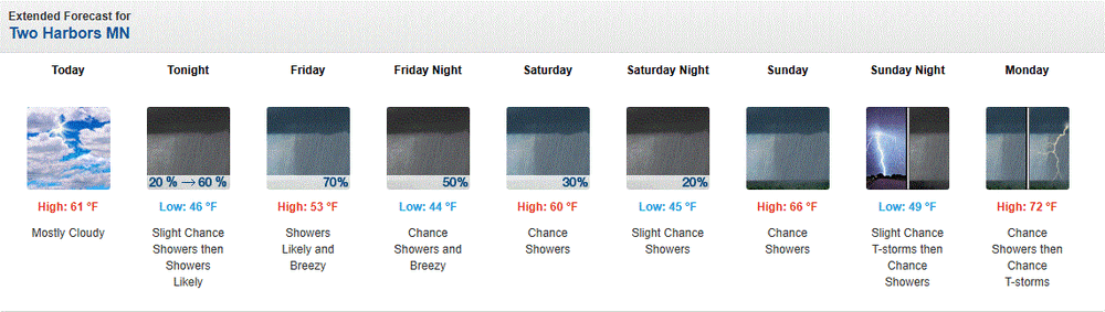
Going to be a long crappy Father's Day weekend for many
-
2 hours ago, A-L-E-K said:
Sucks 4 u

-
4 hours ago, frd said:
The long range still shows no real extreme heat. Next week might be trending downward with temps as a more Easterly flow may set up.
The main heat areas are out West. Precip is never that far away. Granted the actual amounts may vary.
.thumb.png.8f6a0ac8b350094e848b680ade1de055.png)
July will be rockin'

-
 1
1
-
-
On 3/26/2025 at 2:26 PM, Brian D said:
On Father's Day, I'm expecting a front moving into the W sub with fair wx in the E areas.
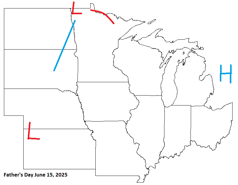
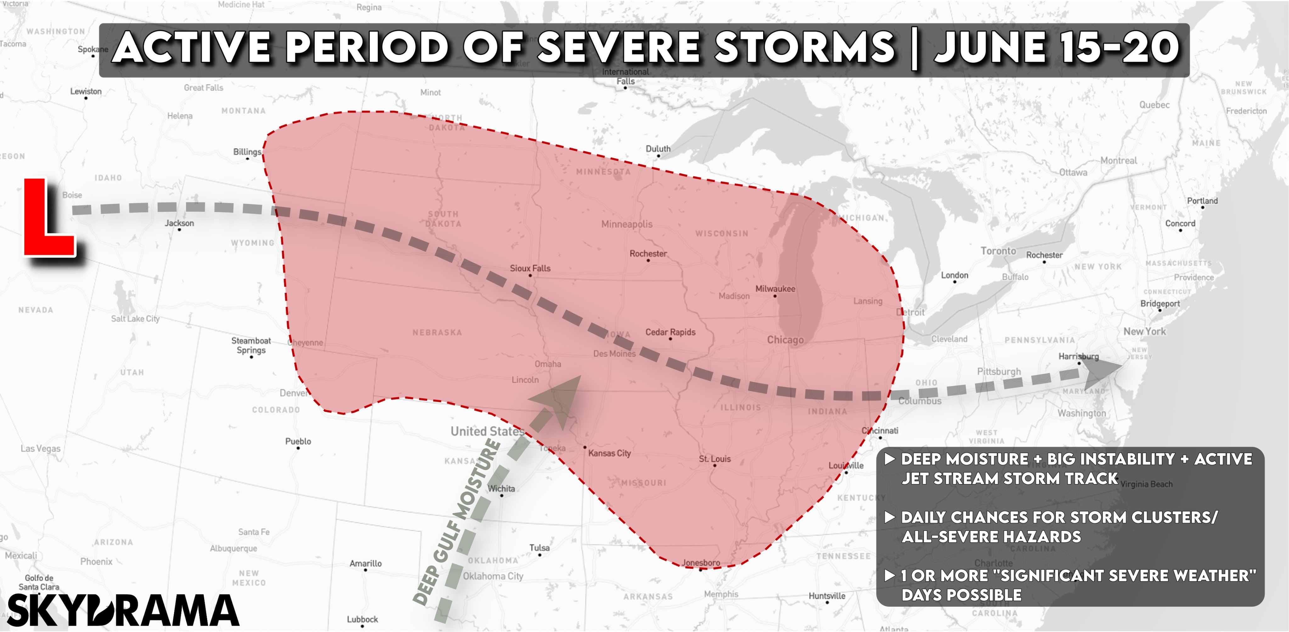
Looking real active for Father's Day weekend for many
https://x.com/skydrama/status/1932062862060437972-
1
-
-
Certainly a lame May this year. Good riddance.
000
CXUS51 KILN 010530
CF6DAY
PRELIMINARY LOCAL CLIMATOLOGICAL DATA (WS FORM: F-6)

                                          STATION:   DAYTON OH
                                          MONTH:     MAY
                                          YEAR:      2025
                                          LATITUDE:   39 54 N
                                          LONGITUDE:  84 12 W

  TEMPERATURE IN F:       :PCPN:    SNOW:  WIND      :SUNSHINE: SKY     :PK WND
================================================================================
1   2   3   4   5  6A  6B    7    8   9   10  11  12  13   14  15   16   17  18
                                     12Z  AVG MX 2MIN
DY MAX MIN AVG DEP HDD CDD  WTR  SNW DPTH SPD SPD DIR MIN PSBL S-S WX    SPD DR
================================================================================

 1  78  62  70  11   0   5 0.28  0.0    0 13.5 36 240   M    M   8 13     50 250
 2  76  60  68   8   0   3 0.16  0.0    0 10.9 25 240   M    M   8 38     32 230
 3  60  48  54  -6  11   0 0.66  0.0    0 13.6 32  60   M    M  10 1      44  50
 4  63  47  55  -5  10   0 0.67  0.0    0  6.7 21  20   M    M  10 13     27  10
 5  60  47  54  -7  11   0 0.07  0.0    0  5.6 10 220   M    M   9 1      14 150
 6  70  51  61   0   4   0 1.16  0.0    0 12.8 26 270   M    M  10 1      35 260
 7  74  51  63   2   2   0 0.00  0.0    0  4.2 16  10   M    M   6        16  10
 8  70  47  59  -3   6   0 0.00  0.0    0 10.8 23  10   M    M   6 1      29 360
 9  64  41  53  -9  12   0 0.00  0.0    0  9.8 17 360   M    M   1 1      24  30
10  76  44  60  -2   5   0 0.00  0.0    0  3.2  8 210   M    M   3        11 210
11  80  50  65   3   0   0 0.00  0.0    0  8.4 16  40   M    M   6        20  70
12  72  59  66   3   0   1 0.17  0.0    0 10.2 17 110   M    M   9 1      24 100
13  76  63  70   7   0   5 0.27  0.0    0  6.0 16 230   M    M   9 138    20 230
14  73  60  67   4   0   2 0.03  0.0    0  7.8 18 210   M    M   9 138    23 180
15  86  63  75  11   0  10 0.00  0.0    0 10.8 21 200   M    M   5        30 200
16  83  62  73   9   0   8 0.50  0.0    0 13.9 31 230   M    M   7 13     51 230
17  70  60  65   1   0   0 0.09  0.0    0 16.6 30 260   M    M   5 13     40 260
18  73  56  65   0   0   0 0.00  0.0    0  9.0 14 320   M    M   5        20 330
19  76  50  63  -2   2   0 0.00  0.0    0  7.0 16  60   M    M   6        23  70
20  63  52  58  -7   7   0 0.53  0.0    0 13.4 22 130   M    M   9 1      29 100
21  67  54  61  -5   4   0 0.07  0.0    0 14.9 29 260   M    M  10 1      38 270
22  58  47  53 -13  12   0 0.02  0.0    0 14.3 22 280   M    M   9 1      30 260
23  64  43  54 -12  11   0 0.01  0.0    0 10.9 24 280   M    M   4        34 290
24  68  45  57  -9   8   0 0.00  0.0    0  6.0 15 350   M    M   4        23 290
25  66  47  57 -10   8   0 0.00  0.0    0  5.0 15 360   M    M   7        18 360
26  71  46  59  -8   6   0 0.00  0.0    0  9.8 18  50   M    M   6 8      35  30
27  66  56  61  -6   4   0 0.03  0.0    0 11.3 18  90   M    M   M 1      25  90
28  64  55  60  -8   5   0 0.05  0.0    0    M  9 210   M    M   M 1      13 210
29  74  58  66  -2   0   1    T  0.0    0  6.8 15 270   M    M   9 18     21 290
30  73  57  65  -3   0   0 0.23  0.0    0  6.7 22 320   M    M   9 138    32 320
31  69  53  61  -7   4   0 0.00  0.0    0 11.9 22 330   M    M   5 8      29 340
================================================================================
SM 2183 1634       132  35  5.00  0.0    291.8          M      204
================================================================================
AV 70.4 52.7                               9.7 FASTST   M    M   7    MAX(MPH)
                                 MISC ---->    36 240                 51 230
================================================================================
NOTES:
# LAST OF SEVERAL OCCURRENCES

COLUMN 17 PEAK WIND IN M.P.H.

PRELIMINARY LOCAL CLIMATOLOGICAL DATA (WS FORM: F-6) , PAGE 2

                                          STATION:   DAYTON OH
                                          MONTH:     MAY
                                          YEAR:      2025
                                          LATITUDE:   39 54 N
                                          LONGITUDE:  84 12 W

[TEMPERATURE DATA]      [PRECIPITATION DATA]       SYMBOLS USED IN COLUMN 16

AVERAGE MONTHLY: 61.6   TOTAL FOR MONTH:   5.00    1 = FOG OR MIST
DPTR FM NORMAL:  -2.4   DPTR FM NORMAL:    0.49    2 = FOG REDUCING VISIBILITY
HIGHEST:    86 ON 15    GRTST 24HR  1.23 ON  5- 6      TO 1/4 MILE OR LESS
LOWEST:     41 ON  9                               3 = THUNDER
                        SNOW, ICE PELLETS, HAIL    4 = ICE PELLETS
                        TOTAL MONTH:   0.0 INCH    5 = HAIL
                        GRTST 24HR  0.0            6 = FREEZING RAIN OR DRIZZLE
                        GRTST DEPTH:  0            7 = DUSTSTORM OR SANDSTORM:
                                                       VSBY 1/2 MILE OR LESS
                                                   8 = SMOKE OR HAZE
[NO. OF DAYS WITH]      [WEATHER - DAYS WITH]      9 = BLOWING SNOW
                                                   X = TORNADO
MAX 32 OR BELOW:   0    0.01 INCH OR MORE:  18
MAX 90 OR ABOVE:   0    0.10 INCH OR MORE:  10
MIN 32 OR BELOW:   0    0.50 INCH OR MORE:   5
MIN  0 OR BELOW:   0    1.00 INCH OR MORE:   1

[HDD (BASE 65) ]
TOTAL THIS MO.   132    CLEAR  (SCALE 0-3)   1
DPTR FM NORMAL     7    PTCLDY (SCALE 4-7)  16
TOTAL FM JUL 1  4796    CLOUDY (SCALE 8-10) 14
DPTR FM NORMAL  -339

[CDD (BASE 65) ]
TOTAL THIS MO.    35
DPTR FM NORMAL   -59    [PRESSURE DATA]
TOTAL FM JAN 1    60    HIGHEST SLP M ON M
DPTR FM NORMAL   -51    LOWEST  SLP 29.53 ON 16

[REMARKS]
#FINAL-05-25#
First colder-than-normal month since February and the third colder-than-normal month of 2025 (Yes, there was a cold January and February this year).
-
Scott Sabol has some sort of "What went wrong?" writeup regarding this Spring
https://sabolscience.blogspot.com/2025/05/why-has-spring-been-so-wetcool.html?m=1 -
-
1 hour ago, TheClimateChanger said:
Looking like it could be a very smoky June on tap.
Like June 2023?
-
First month of meteorological summer is near. Looks like we virtually start up warm after the month begins, but it looks to be a head-fake as it goes downhill again by the end of next week.
-
9 hours ago, A-L-E-K said:
12z Euro:

12z GFS:
-
Let the can-kicking begin. You're welcome.

https://x.com/commoditywx/status/1927771823401230607BAM bringing up 2014 in one of his recent tweets, especially for the upcoming month.

https://x.com/bam_weather/status/1927872832618336344In other news, the SOI has had daily significant rises over the past several days.
Date Tahiti (hPa) Darwin (hPa) Daily Contribution 30 day Av. SOI 90 day Av. SOI 29 May 2025 1016.49 1012.15 21.54 2.95 5.11 28 May 2025 1016.80 1012.00 25.07 2.16 4.87 27 May 2025 1016.16 1010.80 29.36 0.86 4.61 26 May 2025 1015.39 1010.80 23.46 -0.51 4.31 25 May 2025 1014.17 1010.55 16.03 -1.20 4.14 24 May 2025 1014.48 1009.90 23.38 -1.77 4.09 23 May 2025 1012.50 1010.10 6.68 -2.75 3.88 22 May 2025 1011.49 1011.10 -8.71 -3.23 3.82 -
2 hours ago, cyclone77 said:
Bring on the ring of fire. This pattern's boring.
Garbage over the next couple days starting tomorrow, but a slow warm-up by next weekend to end the month.
-
From IND's Long Term:
.Next week...

The overall weather pattern begins to shift next week as the upper
jet becomes more west-southwesterly aloft and the storm track lifts
northward into Indiana. Closer to the surface, high pressure begins
to lose its influence over the state as a developing area of low
pressure in the Plains and associated frontal boundaries lift
northward into Indiana. Low pressure is expected to ride along the
warm front extending over the Ohio Valley and provide perhaps the
best opportunity for more widespread rain and embedded thunderstorms
Monday night through Tuesday. The focus for greatest convective
coverage will again be over southern counties in closest proximity
to the warm front and track of the surface low. By Wednesday, an
upper low will be in place over the Upper Great Lakes while Indiana
is in in the wake of the passing surface low to the east. While it
is difficult to forecast subtle waves within the upper jet this far
out, this pattern would support continued mostly cloudy conditions
with showers as weak waves rotate around the upper low to the north.
Keeping the forecast more pessimistic mid week based on the overall
weather pattern.

Confidence decreases mid to late next week and into the following
weekend as some longer range models have been consistent in showing
another cut off low pattern developing. Guidance usually struggles
with patterns featuring weakly forced systems, so confidence remains
low in the finer details this far out. For now, keeping a close eye
on the potentially cool and wet pattern going into early June as any
warm up back to normal may be fairly brief.

Should the forecast pan out with highs remaining below 70 through at
least Tuesday here at Indy, this would mark a consecutive string of
8 straight days of sub-70 degree weather extending back to this past
Tuesday 5/20. The last time Indianapolis experienced this for such a
long period of time this late in the Spring was from 5/25 to 6/2 in
1889. The search for a return to more persistent warmth likely is
still 7-8 days out and possibly beyond with 80s likely to return by
early in the week of June 2.
Yep, another cutoff low in the middle of next week heading into the first week of June.

So far, DAY and CMH have had 15 days with measurable rainfall for this month as of yesterday. It will add up a bit next week. The record for most days with measurable rainfall for DAY is 21 days in May 2003 while CMH's record is 22 days in May 2004. Could be creeping toward the record by the end of next week. -
On 5/22/2025 at 2:56 PM, mississaugasnow said:
Ive given up on summer ever arriving haha. Lets just get to fall

-
2 hours ago, Stevo6899 said:
As if this shit doesn't suck enough, you gotta keep reminding us how sick in the head you are. Who enjoys this shit in may.
Very few, if anyone at all like JB, in May. Supposed to be stuck in the mid to upper 50s here tomorrow.
Hell, not even in the Northeast because they're expecting a late-season Nor'easter tomorrow.
https://x.com/BenNollWeather/status/1925166136024600730
-
3 hours ago, Malacka11 said:
This cooldown is bullshit.
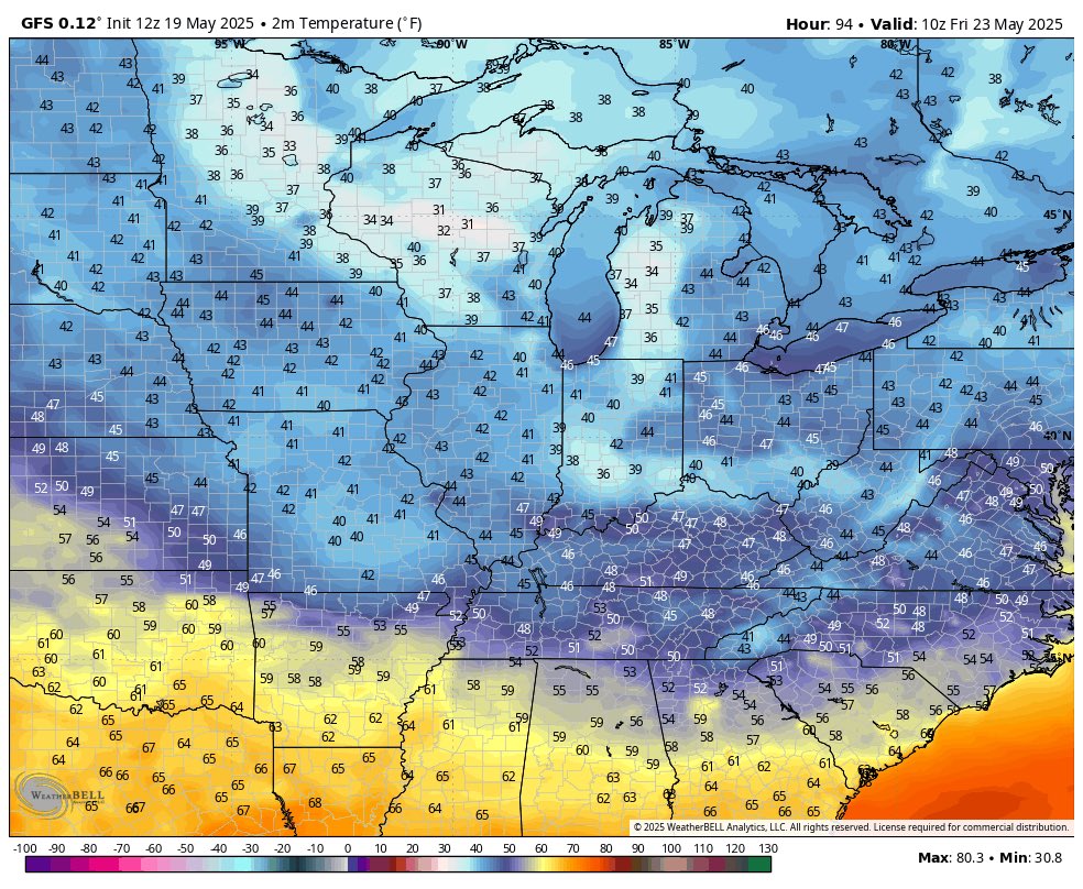
GFS says it's gonna be rather chilly come Friday morning
-
On 5/17/2025 at 9:40 AM, cyclone77 said:
Yeah it feels like we flipped the calendar back a few pages to be sure.
+1
Currently have a departure of +1.2 for this month so far, as of May 18th, but the upcoming cooler than normal stretch this week into next week would make May the coldest month of Spring 2025 by the time the month is over.

.png.b8d007507926352523d20712fa540f1b.png)


Summer 2025 Medium/Long Range Discussion
in Lakes/Ohio Valley
Posted
https://x.com/WxRiskGrains/status/1939524075975581933