

CCHurricane
-
Posts
541 -
Joined
-
Last visited
Content Type
Profiles
Blogs
Forums
American Weather
Media Demo
Store
Gallery
Posts posted by CCHurricane
-
-
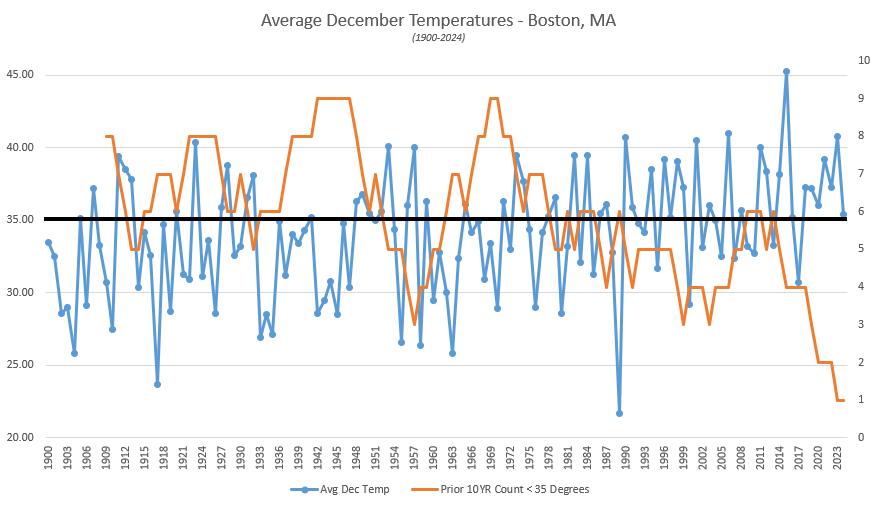
Here in Boston we are currently tracking for our "coldest" December since 2017. Zoom out a bit further however, and it just goes to show how the broader shift in climate is moving the goalposts as to what is perceived as being "cold".
- 2000-2010: 6 of 10 years @ 35 degrees or colder
- 2010-2024: 2 of 14 years @ 35 degrees or colder
-
All things equal, 12Z EURO also showing southern FL landfall, albeit in a much better location and with a weaker system.
Southern FL is mostly Wildlife Area vs. property development further North, yet this thing will be ripping from west to east in terms of forward momentum.

-
 1
1
-
-
12z GFS not backing down. Landfall as CAT 3 just south of Fort Meyers, with it traversing the Florida peninsula in less than 6 hours.

-
2
-
-
00z GFS coming in with a beast...splitting the uprights between Western Cuba and Cancun.

-
On 10/17/2024 at 2:58 PM, powderfreak said:
It was legit. We got 14-15” in two days. Settled to 12” on the ground.


awesome stuff, thanks for the confirm! Hopefully a sign of winter to come...
-
Mount Mansfield Snow Stake reporting 12 inches of snow? That can't be correct...is it?
Would be an a record high for this early in the year, dating back to 1954.
-
2 minutes ago, Blue Ridge said:
SRQ is still transmitting altimeter data, but nothing else.
https://mesowest.utah.edu/cgi-bin/droman/meso_base_dyn.cgi?stn=KSRQ&unit=0&timetype=LOCAL
Looks like a few +100mph gusts may have caused issues.
-
St Pete new high gust to 91mph @ 10:15PM.
Did we lose the Sarasota Airport station? Looks like updates have ceased.
-
8 minutes ago, WolfStock1 said:
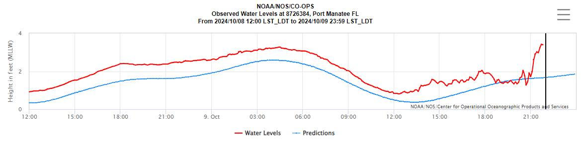
Fat lady hasn't sung yet on the surge in Tampa Bay.
Believe there’s some nuance to this data based on this gauge location. Looks to be exposed to a north wind. The three other Tampa Bay gauges all are running many feet BELOW normal, as the ocean has evacuated towards Tampa Bay’s mouth.
-
 6
6
-
-
7 minutes ago, SnowGoose69 said:
00Z Euro makes landfall at St. Pete Beach
Goalposts narrowing between Treasure Island & Longboat Key. Regardless of Milton's exact landfall location, impacts will be devastating, yet on a relative basis a St. Pete Beach landfall would be close to a worst case scenario...
-
00z Hurricane Models at or just prior to landfall. Not nearly as much weakening as was previously modeled.
HAFS-A/B take an E/ENE track from these points of reference. HWRF and HMON continue to put St. Pete (and the mouth of the Tampa Bay waterway) in the bullseye.

-
5
-
-
A narrowing of spread on the 00Z GEFS.
A few members still north of Tampa, with a Venice outcome looking less likely. Goal posts look to be focusing around the Bradenton cluster.

-
1
-
-
00Z GFS looks a bit quicker in terms of gaining latitude, yet doesn't look to translate to a further north landfall. Another Bradenton Beach landfall.
00Z ICON brought Tampa landfall back into play.

-
3
-
-
18Z GFS shifted slightly north, bringing a Tampa Bay mouth landfall back in to the picture.

-
3
-
 1
1
-
-
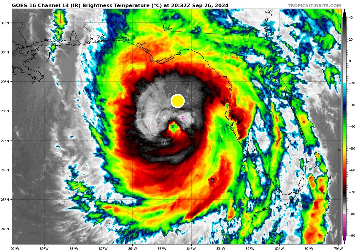
7 minutes ago, MUWX said:
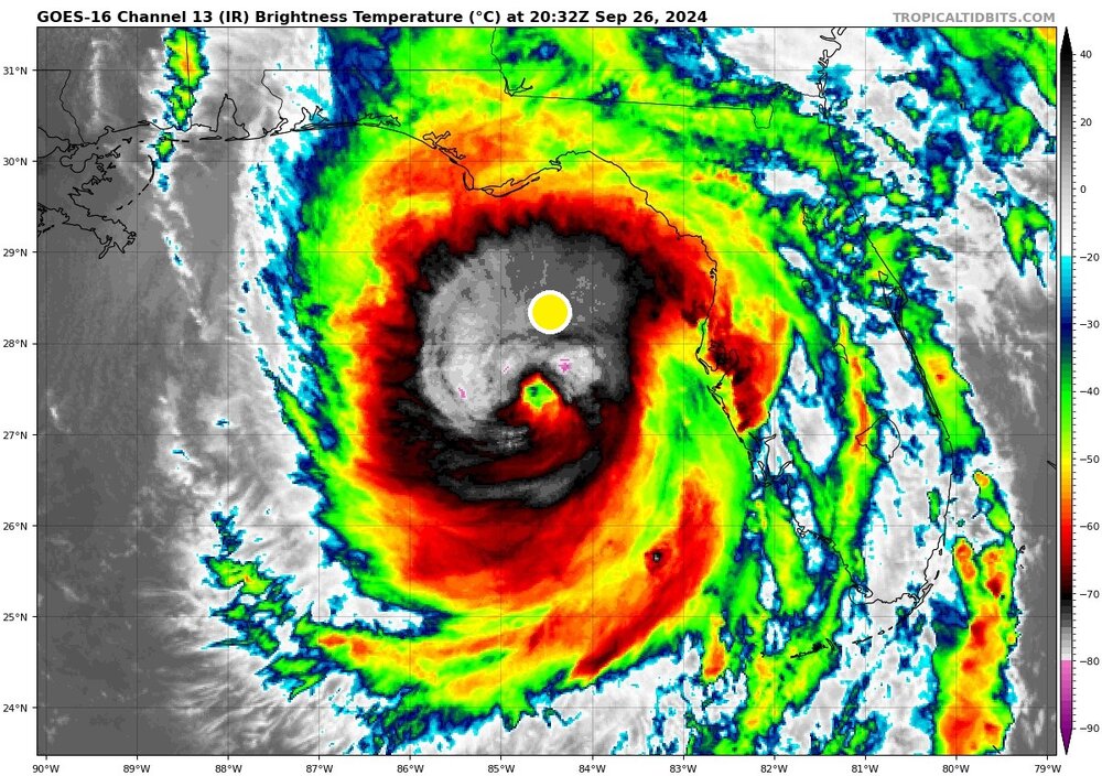
Andy Hazelton pointed out that yesterdays 12z HAFS-B model run has been incredibly accurate so far, and it depicts Milton going to 880 mb tonight. Could be an absolutely historic night and insane model verification.
potentially more damaging than the pressure, would be the HAFS-A / HAFS-B / HWRF track, which continue to be on the northern side of the model suite. A Clearwater / Treasure Island vs. Bradenton landfall will make a significant difference those within the Tampa Bay waterways.
-
1
-
-
Will be interesting to see if Milton follows the same model trends that Helene did.
For Helene, I believe the hurricane models consistently showed a further west landfall than the Operational ones, with the NHC stubbornly sticking by the more west track (despite Helene being outside the cone of uncertainty as it approached landfall).
Wonder if we’ll see the same Hurricane Model bias, which is somewhat already beginning to show, with Clearwater / St. Pete still in play vs. the Operational shift to the south.
-
9 minutes ago, RU848789 said:
As I mentioned earlier in the thread, one of my pet peeves with the NHC is them not always providing a location/windspeed/pressure of the landfall point for the center of their track. I know they like to highlight that "users are reminded to not focus on the details of the forecast as there remains significant uncertainty in the eventual track and intensity of Milton" but I still think they should share at least the landfall forecast, as people want to know and without that info, people end up doing their own estimations of landfall location and strength, which is worse, IMO.
For example, the 11 pm advisory contains the point off the coast in the map below (27.1N 83.3W), but guessing exactly where exactly landfall will be has some uncertainty as one has to look at the track and eyeball it. It's certainly a bit south of the 5 pm track (the little grey dropped pin was the point NHC gave at 5 pm, i.e., 27.9N 82.6W), which is why I would guess Anna Maria Island, due west of Bradenton, which would mean the storm would still kind of go NE into Tampa Bay, but barely; the 11 pm track represents about a 15 mile shift SE from the track at 5pm (by my eyeball and I'd rather not be relying on my eyeballs, lol) and and another 10-20 mile shift might be enough to spare Tampa the worst surge.
The NHC "knows" the landfall point - I just wish they'd share it. As an aside, is there some service out there that actually calculates it?
https://www.nhc.noaa.gov/refresh/graphics_at4+shtml/032137.shtml?gm_track#contents
Check the "Track" option and zoom in
-
2
-
-
6 minutes ago, Brasiluvsnow said:
I have not read thru the thread but I have a question = How often has a Hurricane that has affected Florida originated from the Gulf don't they usually come up from the southern Gulf or loop around after they were initially heading west ? A hurricane starting directly from the southwestern Gulf, like Milton did, and heading due east into Florida's west coast is definitely IMO not common but has THIS ever happened in the past ? Thanks for any replies
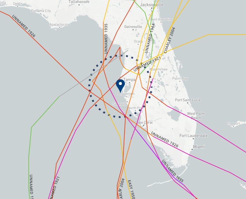
While it's happened before, historically its very infrequent for the Tampa Bay area.
Looks like the last major hurricane (> Cat 3) to impact the Tampa region, with a west to east or southwest to northeast track, was back in 1921.
-
1
-
 1
1
-
-
-
5 minutes ago, wthrmn654 said:
31? Which buoy is that by chance the one that's less then 31 miles away is showing 20 feet now
https://www.ndbc.noaa.gov/station_page.php?station=42036
Approx Buoy Location in YELLOW
.png.9b4f3c08855bca26733d5488ef6cc5c3.png)
.png.39ecf5d7857d3eed63a4bd90b4abcef3.png)
-
1
-
-
3 hours ago, DavisStraight said:
How were the last two years up North?
Using the Mansfield Snow Stake (Stowe,VT) as a proxy...last three years.
- 2021-2022 was a challenging year throughout
- 2022-2023 struggled for most of the winter, yet rallied with some late season (albeit short lived) magic
- 2023-204 followed a similar path, pockets of decent storms followed by snowmelt below average, with March delivering a short lived season ending snowfall bump.
.thumb.png.03edb46f94e4623714dc85da3a73ec54.png)
-
2
-
1
-
19 hours ago, weatherwiz said:
This site has a slew of different products you can create graphs for. I wish it was a little more user friendly but its top notch
Thank you, will explore and get used to the UI.
-
1
-
-
Question for the group here; while the xmACIS2 database is great at visualizing historical info across basic variables (temp, snowfall, precip), is anyone aware of a resource that includes additional data such as dewpoints, humidity levels, etc?
-
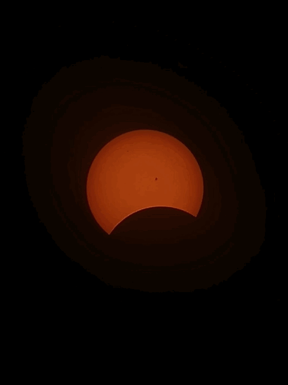
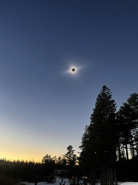
Road tripped from Boston up just south of Jackson, ME.
Totality is a whole other ballgame.
Kudos to my buddy’s Samsung Galaxy, wildly good camera setup for a phone!
-
8
-


.png.a320e05dbf169d2c43fdf25d8b7ccd34.png)

December 2024 - Best look to an early December pattern in many a year!
in New England
Posted
00z NAM turning back the clock a few days to show a nice moderate event tomorrow evening, with a Cape Cod jackpot if it can stay cold enough. Likely cut these numbers by 25-50%…but would be a beautiful and COLD weekend.