Buffalo Bumble
-
Posts
1,613 -
Joined
-
Last visited
Content Type
Profiles
Blogs
Forums
American Weather
Media Demo
Store
Gallery
Posts posted by Buffalo Bumble
-
-
6 hours ago, weatherbo said:
Nam NOT backing down on snow or qpf. This could be one for the books.
Weenie flag flying.
What’s your elevation?
-
Sorry to hijak the thread but my daughter just left the Harp to take a run in the snow falling in Boston in hopes of some good vibes to push the Bills over the Dolphins. No bad will towards the Pats intended!
-
1 hour ago, Terpeast said:
I used to live there during college. It was always extremely muddy throughout the year.
You guys are killing me with these Buffalo posts (I lurk in here b/c you have great long range discussion). Seeing people running through the neighborhood yesterday in shorts and t-shirts with 867” of snow on the ground was quite amusing. Hope you guys bust out of the snow drought soon!
-
 8
8
-
-
19 hours ago, wxeyeNH said:
I live in NH but just checking out this thread. Wow. So sorry for all the people that lost their lives. It must have been a horrible way to go, slowly freezing in your car or outside. I know we talk about climate change and events. I am curious as to the lake water temperatures this fall. Were they above normal which would lead to heavier lake events? If so I wonder if the lake water was closer to normal might the snow bands be slightly weaker? Of course a storm of this magnitude would produce heavy snow no matter what but warmer lake water temperatures in the future may increase the likely hood of heavier lake effect. Snow
IMO any increase in lake temps due to AGW has a negligible if not totally de minimis affect on lake effect snow totals. The intensity of lake affect snow depends on so many variables. Wind direction in lower and upper levels, wind speed, available moisture and, yes, air/lake water temp differential. I think if this same event happened and the lake temp was 3 degrees warmer because of AGW, maybe somewhere gets one inch more. Negligible.
I’m sure there’s a scientific analysis you could run to pin this down but my hunch is the numbers would show little to no effect.
-
2
-
-
Picked up about 8” here (Chaumont) last night as the Lake Ontario band strengthened and moved through. A calm, moderate snow with cotton ball flakes is falling now as this five day storm draws to a close. Headed home to Buffalo tonight where I’ll be greeted by 3-4 feet of snow in my driveway and along my sidewalks and probably 5’ at the end of the driveway. Woohoo!
-
1
-
-
12 minutes ago, BuffaloWeather said:
Death toll is up to 27
This is hard to hear and so tragic.
-
 3
3
-
-
Been posting on Discord but for posterity’s sake here’s a quick rundown of the event so far from Chaumont, northern Jefferson County…Blizzard conditions quickly developed behind the cold front on Friday. Snow fell throughout the night with frequent wind gusts over 60mph. The blizzard raged all day Saturday, no drop in winds. Snowfall wasn’t heavy here but visibility ranged from zero to less than 1/4 mile. No relief through Christmas Eve night. Winds slightly lessened on Christmas morning as heavy snow moved in (to this point, Lake Ontario wasn’t producing heavy lake effect snow due to pretty extreme wind sheer). On and off heavy snow during Christmas Day, heaviest just south of here on the northern Tug. Winds dropped to 20-40mph by Christmas night. Heavy snow ongoing now as the band shifted north overnight. 24-30” on the ground in protected areas here. On the backend of the storm now but conditions are still intense with the heavy snow and gusty winds. I’ll post some photos later…
-
4
-
-
9 hours ago, BuffaloWeather said:
I got this drift on my live stream tonight
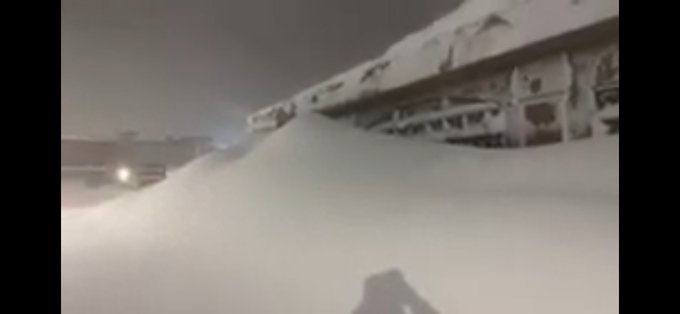
Heres the full walk
Rich, this was epic!! Awesome job!
-
 1
1
-
-
3 hours ago, London snowsquall said:
Currently in prince Edward county west of Kingston ON just north of lake Ontario. Blizzard conditions most of the time. Son in law rescued local farmer lost in a nearby field. He was totally lost and disoriented. The local road in front of daughter's house is impassable with 5 ft. drifts. Top wind gust locally to 128kph. Here - this is definitely a blizzard.
I’m just on the other side of the border, in Chaumont, NY. I can attest to the blizzard! Not too much snow here, guessing about 8” since yesterday, but visibility has been between 0 and 1/4 mile for going on 30 hours with frequent gusts well over 50mph. Looks like you had the brunt of the snow over there today as winds have been more S/SW.
-
1 hour ago, BuffaloWeather said:
This storm will rival the Blizzard of 1977.
Absolutely. Just the videos so far are unreal.
-
4 hours ago, BuffaloWeather said:
Check your pms stash.
Childish I know, but this made me lol. Read it slowly…
-
 1
1
-
-
53 minutes ago, SunWX said:
Long time reader, first time poster. Before I ask question I just want to take a moment and thank all the contributors to this forum over the years, its been a great resource for the big storms and I have learned a lot.
I have a friend who was going to drive from Montreal to Pittsburgh via I-81 and I-90 on Saturday (tomorrow) and I told him no way, as he would be driving along the southern boarders of Lake Ontario and Lake Erie (the wall of the storm). My question is, he agreed to postpone traveling till Sunday (normally a 10 hour drive) so do you think the highways in those hard hit regions will be open or clear by Sunday afternoon?
Personally I don't think so, but I was being optimistic if the Saturday night and Sunday morning accumulation is less than predicted.
If your friend is taking 81, tomorrow might actually be the better day. The lake effect should be “off” both highways as it gets directed into Canada on S/SW winds. Traveling down 81 on Sunday will probably involve driving through a band somewhere, same on the 90 south of BUF. Other option is take 87 to the 90 on Sunday.
EDIT: Tomorrow is definitely better for that drive.
-
About 3” here in the last hour with just one but very impressive thunder snow.
-
1
-
-
12 minutes ago, wxcwman said:
When does the main event start
Looks like winds have shifted to SW over the west end of L Erie so I would think a few more hours for a new band to fully form. So around 7pm is my guess.
-
10 minutes ago, BuffaloWeather said:
Kbuf upgraded again...

That’s like a Sierra’s forecast during an atmospheric river event. Actually, this is like a 30 mile wide atmospheric river, Great Lakes style…
-
1
-
-
13 minutes ago, Typhoon Tip said:
I was but a small boy in Kalamazoo Michigan - I didn't become a "masshole" until I was early teenage and moved to this region of New England... But Kalamazoo resides just barely east of the western Michigan LE belt. Once in a blue moon the belt would shit and the 1/16th mi vis would hide the city-scape. By and large..we were always watching the white wall just to our west. It was horror for a fledgling little obsessive weather dweeb. Pure torture! Alas, there would be no chase at an 9-year old.
Actually, there was often another band that was NE of the city two. The really infuriating days was when the afternoon sun was setting behind a fuzzy gray wall west, while NE belt was brilliantly lit, and we had meager scattered virga busted CU with a flurry or two over head. Those bands were notorious 8"ers... there. 18" in Van Burren County. There's actually under an Advisory tonight for the season's first LE event.
I miss that some... Some of the best one's are when it got so cold the whole structure just deteriorated into this cryo mist... I delivered papers in 0 F, with chalks dust blowing sideways and the orb of the sun dimly visible ... It was like a tundra scene.
Dude…we lived dual adolescent lives but off different Great Lakes. I grew up about 20 miles west of Syracuse, or 15 miles south of the Lake Ontario snow belt. Many midwinter days after arctic fronts passed by under cobalt blue skies with temps in the teens and a stiff W/NW wind while the northern sky was black as night. My ground was frozen with 1/4” post FROPA snow cover while competing school districts to the north were canceling sporting events due to 36-48” episodes. First chase to the far northern kingdom 15 miles away post drivers license was enlightening.
-
4
-
1
-
-
2 minutes ago, Typhoon Tip said:
Are you here for a longish while? If you're a snow monger ...you'd be right to return this next week. Some guidance has the LE climo snow hose suffocating the typical zones back there...
Back to BUF on Monday, chasing the lake effect snow next week as the snow monger in me compels me to do.
-
1 minute ago, Typhoon Tip said:
You may have been able to prevent some of your humility if you'd considered that "earlier last week" aspect. Lol. Maybe our expectations in the wild ranges of autumn are just little high ? Unless by earlier in the week you mean the day before - but that sounds like it was 5 forecast.
Haha, totally my bad. I saw a New England bomb and totally got sucked in. All model runs after that were just noise.
-
Personal Boston forecast bust…In town visiting my daughter today. Based on model runs earlier last week I said forget about any outdoor stuff today. Told her to plan for rain at best, tempest at worst. Got busy at work and didn’t check forecast before arriving last night. After spending the day bar hopping downtown with temps in the low 70’s and a comforting summer breeze I’ve lost all credibility as a weather hobbyist. Boston weather humbled me today, I’m sure the Bruins will do the same to “my” Sabres tonight.
-
2 hours ago, winter_rules said:
We had a dusting at 11:15pm, 10 inches of white concrete on the ground at 2:15am. Also broke a bunch of branches and trees, and we haven’t had power since about 2:30am, not expecting it back for quite a while. Maybe tomorrow?
A big branch took down our overhead electric service and pulled the pole to a 45° angle rather than pull the mount off the house!
The sound from 2am to about Noon when I left for work was wild. At 2am we could hear branches snapping (and the following muffled crash down to the ground) in the dark every 1-2 minutes all around us. By Noon it had slowed down to probably one every 5 minutes. I started trying to put broken branches into a pile but quit after two nearby branches broke overhead and came crashing down. Not cool. We have quite a mess to clean up.
That’s exactly what we experienced during the October 2006 storm. Like continuous musket shots. Don’t envy you at all, the mess is both difficult to clean and depressing seeing the impact to trees. We can still see evidence of the 2006 storm to this day in lopped off tree tops and funky shaped trees.
-
2
-
-
I’ve been thinking we’ve had a long stretch of weekends with mostly bad weather. So I checked…Every weekend since December 1st has had at least one day with precip. Doesn’t mean every weekend has been a washout or snowy but not a single Sat/Sun with no precip since 12/1. Didn’t look back farther than that…It’s our climo I guess.
-
2
-
1
-
1
-
-
Is April really a spring month here? You could make a case for it being a winter month. Mild temps are generally in advance of a cold front and last a couple days or less, base weather is cloudy/damp/cool to cold/occasional snow showers. So Jan through April = winter; May and June = spring; July through Sept = summer; Oct = fall; Nov and Dec = winter. That’s 6 months of winter.
-
2
-
-
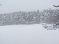
Periods of moderate snow all morning. Deep, deep mud in the yard. Numb hands walking the dog. Thanks April.
-
1
-
-
1 hour ago, BuffaloWeather said:
That’s absolutely terrifying. Puts the risk of chasing let alone driving in heavy snow rates in clear perspective. And that person literally diving out of the way…
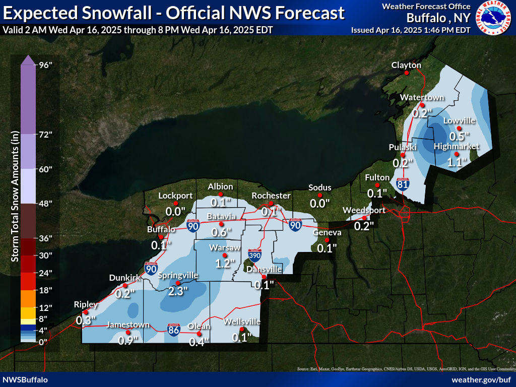
April 2023 General Discussion
in Lakes/Ohio Valley
Posted
Incredible setup. Look forward to reading your posts the next couple days.