

burgertime
-
Posts
11,230 -
Joined
-
Last visited
Content Type
Profiles
Blogs
Forums
American Weather
Media Demo
Store
Gallery
Everything posted by burgertime
-
NAM looks closer at 5h to the 6z Euro than the GFS out to 63.
-
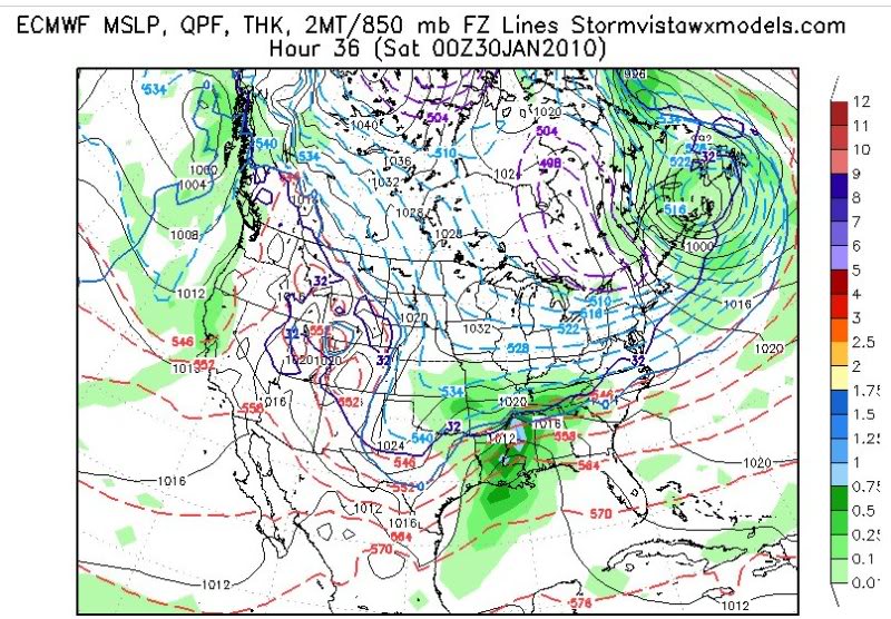
This storm is very similar to the late Jan 2010 storm. I had to go back to my archives but this is what the models showed then. This had less cold air to work with and we ended up with loads of sleet after an initial thump of snow. There was more confluence in the NE which def helped keep it south.
-
Just looking at the map on my phone it looks like thermals would be good enough for snow verbatim up to 93 or so in upstate but it for sure is on the edge. Not much margin there but could be wrong of course.
-
Gonna be inches if 6z is correct.
-
Radar by p-type.
-
For folks in upstate and NC this is before the switch over happens. Points I-40 north see the switch over last. That is still a big dump of snow up front and matches what @HKY_WX was saying yesterday.
-
By hour 96 it's a sleet fest for NC and upstate. The GFS keeps those waves at 500 seperate and doesn't slingshot the low directly into the wedge. This looks more likely.
-
Out to 90 the 6z GFS keeps NC all snow. Upstate area of SC is also snow but on the edge. GA mainly ZR.
-
6z GFS looks better than the Euro out to 84. Front end thump of snow inbound for upstate SC and most of NC.
-
It's better than the euro with the HP but thermals are on a razor's edge for upstate and north. I do think overall it looks better than the Euro but I'm on my phone at the moment and at 84 hours it should be taken with a grain of salt.
-
I haven't been around for many of them but usually there's always some issue like no real high pressure, no real cold air source to our north, relying on dynamics etc.. That's where the NW trend kills chances. Correct me if I'm wrong but you usually don't see this setup where there is tons of arctic air to our north, hp systems in place and this sort of retreat. Just looks wonky to me...but I'm out of practice.
-
Look I wasn't buying the all snow 30 inches in most spots....but I'm suspect of the Euro solution. There's a 1040 high that books it at the last second and all the super cold air gets beat by the storm. It's possible but I'd wait to see what 6z and the models show for later today.
-
Lol it's good to see some things never change around. Everyone there's a cliff diving thread specifically for this. I'm in the camp that it's unlikely a low would plow that far north but we shall see. Timing in that baja low is everything and unfortunetly we still have some time before we know when it will actually kick.
-
I wouldn't let be Euro scare anyone too much. There's really cold air aloft and a strong high funneling it in. Climo says that cold air should be thicker.
-
Sorry I meant warmer than the GFS
-
Euro looks warmer lots of ZR and sleet for NC.
-
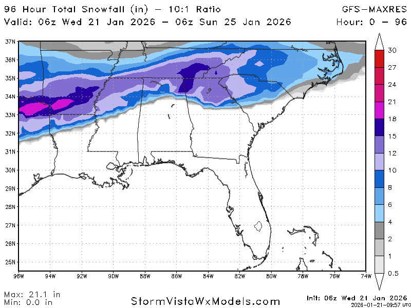
AI GFS out to 138
-
GFS ENS and CMC says yes. GFS and ICON say no. Euro we will see. I think you can't rule it out because it all depends on that airmass...which does look good. I think a safe bet would be that you get a mix of everything with mostly snow. The downside is that if you get a coating of ice on trees then snow on top that leads to trouble. Hopefully though it starts as snow and mixes when it gets lighter.
-
GFS ENS does cool off for most of NC but a lot of easern NC has ZR on this run.
-
Ensemble is a lot warmer at 850's. Would be a lot of ZR across NC.
-
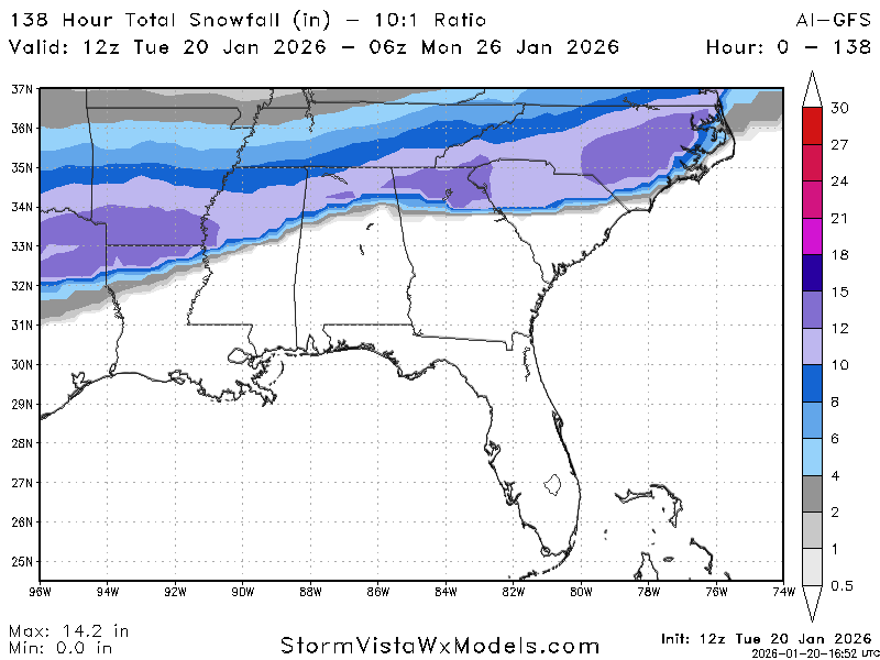
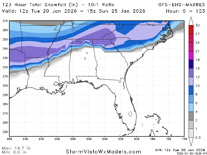
GFS ENS out to 123
-
Gotcha, thanks!
-
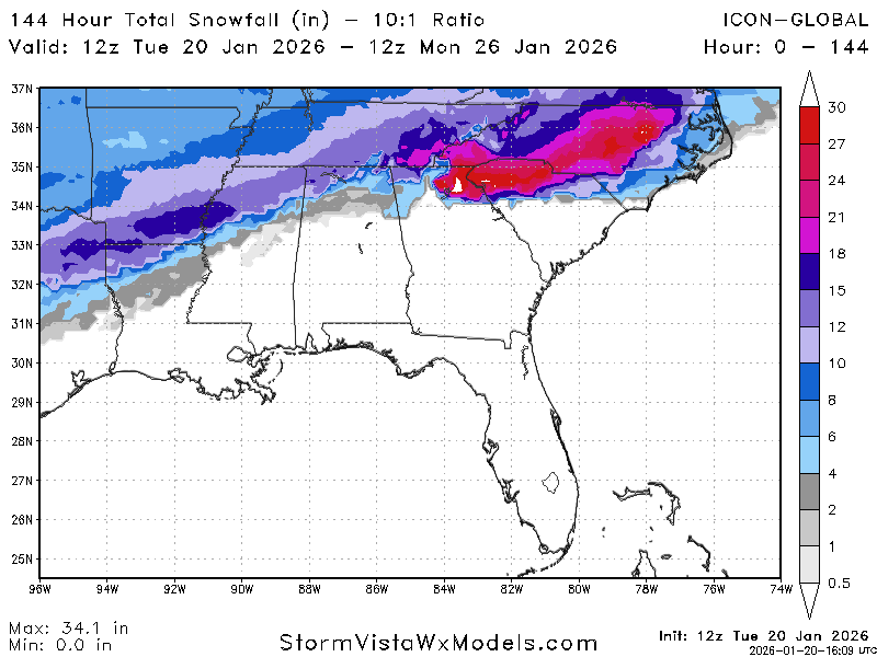
ICON 12z
-
Has the Canadian been verifying well over there? It is absolute garbage here. Euro and ICON seem to always be on top of things in my neck of the woods while the CMC is usually trash.
-
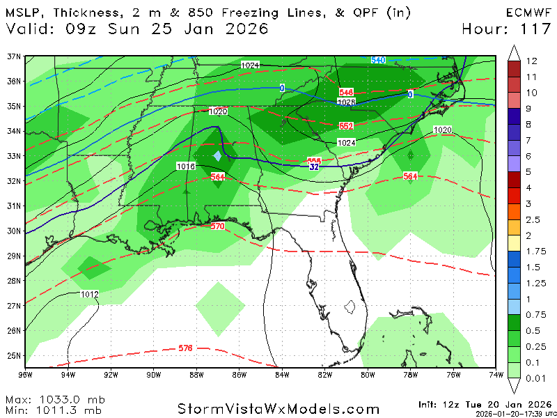
For those interested here is the MSLP with sfc temp and 850 line...


