

Rvarookie
-
Posts
698 -
Joined
-
Last visited
Content Type
Profiles
Blogs
Forums
American Weather
Media Demo
Store
Gallery
Posts posted by Rvarookie
-
-
If you lost power and had to be stuck living with either Ji or Trix who would you pick?

-
 1
1
-
 4
4
-
 1
1
-
-
13 minutes ago, Sernest14 said:
There's a few bands - i think it's trending a little drier with us but still most have us between .8" - 1"+ in total precip.
Thanks I suspect at this point we won’t really know what’s in the bag of goodies or how much of each type until it falls. I know it def felt cold out there for full sun
-
1
-
-
Is it trending drier? Or shifting precip elsewhere?
-
How we looking?
-
Just now, Ji said:38 minutes ago, Deck Pic said:Drier...but still a pretty good run...not any significant changes
Freaking off runs
I guess tonight will be the typical Ji pre-storm meltdown? Can’t wait to read it later!
-
1
-
-
Any thoughts on wind for down in RVA? It wasn’t windy at all last week during ice, but suspect this one looks little breezier which could add more stress
-
Hoping folks that haven’t cashed in much this year get some lovin from this one.
-
34 minutes ago, Inudaw said:
All aboard ice storm 2.0 2021?
Might as well enjoy it instead of fighting it. Just make sure to stock up on liquor since abc bailed on us last go around

-
2
-
-
21 minutes ago, eaglesin2011 said:
Yeah, this is starting to look like the normal sleet fest that we normally get around here.. Maybe a couple inches before change over to sleet the freezing rain/rain
Today will be interesting to see how warm we get ...Forecast is mid 50s
.
Crazy to see va beach sitting at 65 this am
-
1
-
-
I’ll take ice over cold rain. It was pretty cool to experience but having power likely made it fun lol
-
My neighborhood looked so rough this AM. Can’t imagine how it would have been if the ice happened overnight. My electricity and heat were extra appreciated today
-
This next blob might be do me in
-
1 minute ago, RVASnowLover said:
What’s coming our way
What do the models say?
-
2 minutes ago, mikeeng92 said:
Not good. The only way this gets worse is freezing rain with the sun down.
Agree. I think daylight saved us
-
Just now, Snowmadness said:
HRRR looks like 7 more hours of this....ugh. Trees are already creeking loudly with ice.
Radar looks lighter?
-
Trees looking stressed in midlo.
-
Turn lights out and close the blinds?
-
1
-
-
Roads look good out
-
Roads were fine but was a pain to get into car. Skating rink everywhere
-
13 minutes ago, cyclogenesis said:
February 12, 2021
this Friday night
856 PM EST
So, now that everyone know WHAT to expect and WHEN to expect it, I thought I’d open with the topic of UNDERSTANDING the MECHANICS of what’s going on here.
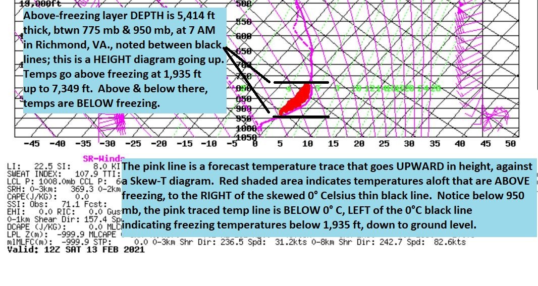
First, we take a LOOK at the mechanics in play: How does the TEMPERATURE profile change WITH HEIGHT? That tells the KEY as to what precipitation type you’re going to get. That is what this attached visual graphic I’m producing here details.
The pink-traced line is a forecast temperature that goes UPWARD in HEIGHT, centered at 7 AM on Saturday morning, over Richmond, Virginia, just after the start of the freezing rain event.
The background of thin, black lines is the skewed temperature scale that angles right-ward with height.
If the pink-traced line STAYS LEFT of the 0°C thin, black line, this means the temperature stays freezing all the way upward in height, if the pink traced line LIES to the LEFT of the 0°C thin black line. In such a case, precipitation would fall as snow. If the pink-traced line STAYS RIGHT of the 0°C thin, black line all the way up, staying RIGHT of it, then it all falls as rain.
But what happens if the pink-traced, (forecast temperature line), crosses over between above-freezing and below freezing?? Then, it can either be FREEZING RAIN, (in this case for tomorrow), or in other times as sleet or even snow some other times.
The DEPTH of the above-freezing layer aloft and the MAGNITUDE, of HOW WARM dictate as to whether it converts to freezing rain, sleet, or snow.
For tomorrow’s case in Richmond, VA on Feb. 13th, I’ve calculated the ABOVE-FREEZING LAYER DEPTH to be 1,650 meters, which is about 5,414 feet in DEPTH, ALOFT, of above-freezing temperatures. (Refer to my visual attachment of the Skew-T).
From ground level, up to 1,935 ft, temperatures are forecast to STAY either BELOW FREEZING or right at Freezing, 32°F. Then between 1,935 ft altitude on upward to ~ 7,349 ft, the temperature goes ABOVE freezing, with the WARMEST peaking at 4°C to 4.5°C between the 900 mb to 850 mb layer about 12 Noon, midday. This layer depth of above-freezing temperatures neither grows nor shrinks in depth throughout the day Saturday, except that the magnitude gets just a little warmer at the 900 to 850 mb layer.
So what happens?? Take it from the top! Falls first as snow, ABOVE 7,500 ft, then begins melting to liquid cold rain in that 775 mb to 950 mb layer of ABOVE-FREEZING temperatures, between 7,349 ft to 1,935 ft. (Refer to my visual attachment of the Skew-T). Then in that last 1,900 ft down to the surface it HITS on contact as freezing rain, SO LONG AS THE SURFACE temperature stays either BELOW or AT 32°. (But why doesn’t it freeze back to snow or sleet between 1,900 ft and the surface??) Great question! The problem here is that the warm layer depth is so deep whose magnitude gets as warm as 4°C, that there isn’t time for the rain drops to freeze back to snow. If the boundary layer temperature was WAY BELOW freezing in the lowest 2,000 ft, as in like mid 20’s or lower, then MAYBE you could get some sleet out of it. There is a pronounced layer right at 975 mb that gets briefly near there, so it’s possible to get a few ice pellets, but predominantly will be freezing rain.
(What determines freezing rain in this case??) So, the depth measurement of the above-freezing layer is about 1,650 meters, and the AVERAGE temperature within that above-freezing layer is running about 1.7°C, almost 2°C. (Refer to my visual attachment of the Skew-T). It does briefly peak to as warm as 4.0 to 4.5°C around midday and afternoon Saturday. With that depth & mean virtual temperature on the Tau Technique, at 1,650 meters & 1.7°C, this equates to a translation of FREEZING RAIN as the dominant type of precipitation, AS LONG AS YOUR SURFACE temperature is at least 32° or below. As soon as the temperature flips to 33° and above, then the jig is up! All the modeling data that I reviewed from Friday points to this being mostly an icing, freezing rain event; however you may occasionally observe some liquid rain mixed in, especially in the afternoon, and some ice pellets, or sleet during the morning. Mostly, should be rain freezing on contact, and may take time to see the ice accretion build by late morning.
That RED-SHADED AREA is that layer DEPTH that is ABOVE-FREEZING, located between an altitude of 1,935 ft and 7,349 ft above ground level.
-- cyclogenesis

Thanks for dropping the knowledge! Awesome write up
-
1
-
 1
1
-
-
16 minutes ago, cyclogenesis said:
February 12, 2021
this Friday afternoon
510 PM EST
Quite an interesting event coming up!! Here's what the latest forecast models from Friday show:
Both of the higher definition forecast models indicate this SHOULD remain mostly a FREEZING RAIN event, in their hour-by-hour indications.
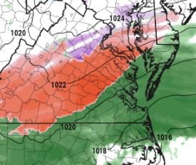
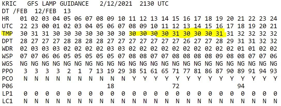
This morning's NAM MOS vs. GFS MOS had a discrepancy in their Saturday afternoon temperatures, whereby Nam kept FREEZING TEMPS at 32°, and GFS MOS went ABOVE freezing to 33° at 1 PM onward in Richmond.
HOWEVER.... newest GFS LAMP guidance from 21Z this afternoon is REVISING these hour-by-hour Saturday AFTERNOON temperatures DOWNWARD, indicating a temperature between 30° - 32° from 7 AM to 4 PM Saturday, through the afternoon.
Looking at the forecast precipitation TYPE.... All models I reviewed are unanimous at pointing towards freezing rain, and ICING for the Richmond area. I do think there will be some periods of SLEET or ice pellets mixed in, and in any outlying areas, where temperatures hover at 33°, then that will yield a cold rain, at a surface temp of 33°, and above.
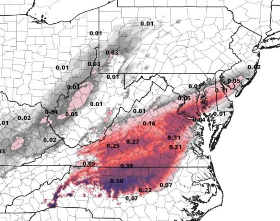
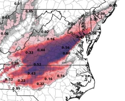
The amounts rendered are the following:
FREEZING RAIN / ICE amounts for Richmond --
HRRR -- 18Z Fri fcst iteration -->> 0.31" of ice, (freezing rain). TIMING 3 AM Saturday -- 7 PM Saturday night
GFS -- 12Z Fri. fcst -->> 0.46" of ice; freezing rain ; Timing 3 AM Saturday thru 10 PM Saturday night
GFS -- 18Z Fri. fcst -->> 0.26" of ice; freezing rain
WRF -- 12Z Fri. fcst -->> 0.56" of ice; freezing rain ; TIMING 4 AM Saturday -- 9 PM Saturday night.
NAM -- 12z Fri. fcst -->> 0.37" of ice; freezing rain; TIMING 1 AM Saturday -- 7 AM Sunday. (That's stretching it!)
NAM -- 18z Fri. fcst -->> 0.44" of ice, freezing rain
This yields an AVERAGE consensus of: 0.4" (4/10"). That is significant icing which will topple trees & tree branches, and cause power lines to sag. It is also enough significant ICING to completely CRIPPLE & DISABLE the entire road infrastructure, both secondary roads and primary roads. I can't emphasize enough to STAY OFF the MOTORWAYS, and avoid driving, starting late tonight, through all of Saturday, Saturday night & Sunday morning.
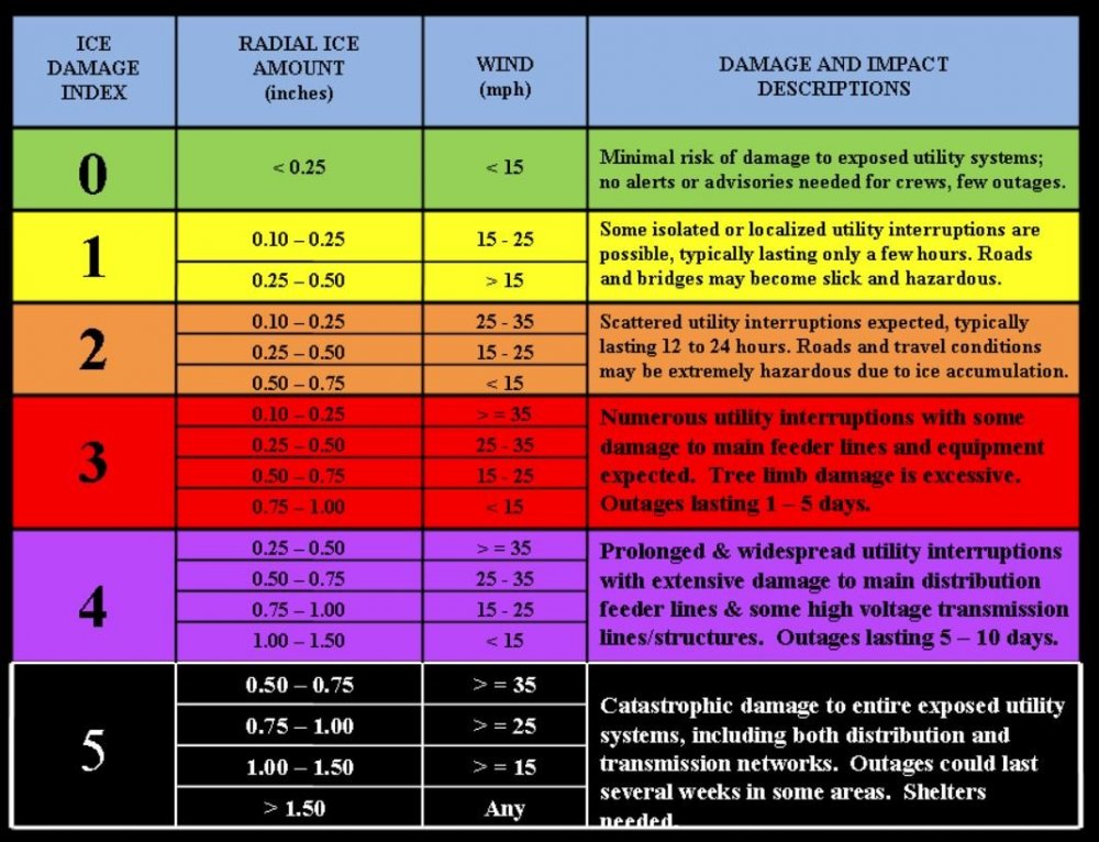
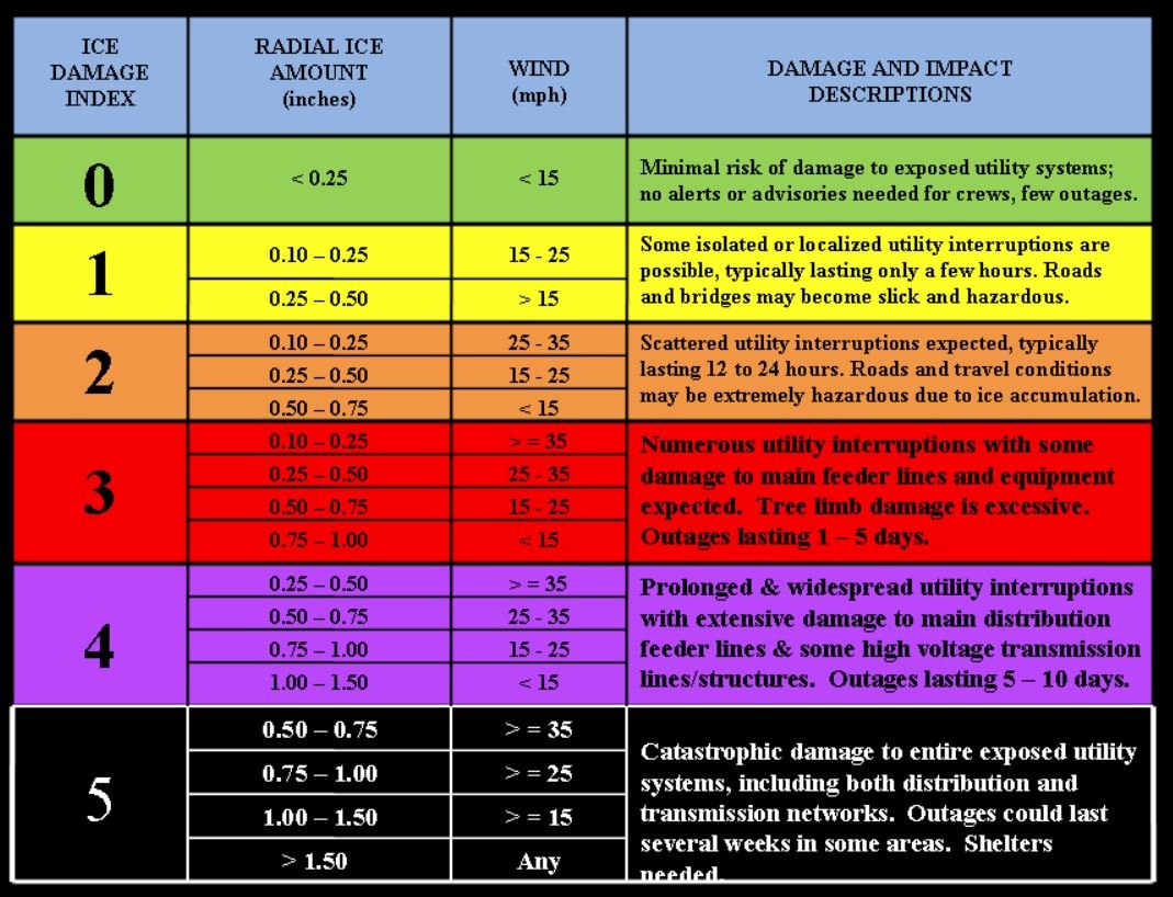
The fortunate GOOD news out of this is that WIND SPEED forecasts are expected to REMAIN BELOW 15 mph.
On the ice damage index, very damaging ice storms occur when WIND SPEEDS GET OVER 15 mph, and winds are forecast to stay below that.
Not to let your guard down, though, because lessons learned from the Dallas interstate 75 -100 car pile-up occurred in only light icing. When I checked back at all the observations at the 3 airports in Dallas - Ft. Worth, Dallas Love Field's ICE ACCRETION sensor ONLY RECORDED just 0.08" of ice accumulation ; LESS than 1/10", but still tragedy of lost control of vehicles occurred so early in the morning on a bridge pitched at a slight decline was enough to send chaos through the air. Also, yesterday, storm reports in Central Texas near Austin, during their ice storm showed surrounding communities of 40,000 left with NO POWER, when icing of 1/4" to 1/2" was encountered yesterday there.
So now, just think about the STEEP & ARCHED curvature to the infrastructure INSIDE the Richmond city limits on Interstates 64 and 95. Everyone should AVOID travelling on the roads, period. Just think of that infamous "stay-at-home" order you'd seen issued a little less than a year ago, and let this ICING event from yesterday in Dallas, be a reminder for tomorrow, in Richmond & surround areas, to STAY OFF THE ROADS altogether, from EARLY Saturday morning, all day Saturday, Saturday night & Sunday morning.
Bridges, hills & curves on the roads are especially dangerous, and Richmond's got plenty of them. Just stay at home and don't drive, from Saturday morning through Sunday morning.
How to inspect the icing?? Go look at THIN tree branches, and feel for the icing. It should be SLICK. The tree branches will SQUEAK in the wind or as you pull on them. Also, chain link fences & antennas on vehicles are other good places to inspect icing. Many vehicles on their undersides, and on SIDE MIRRORS will often show hanging icicles, if out in exposed weather, away from garages and overhangs.
Here are the corresponding attachments that supplement this writing, supporting the ICING AMOUNT TOTALS....
-- cyclogenesis

My man! Thanks!
-
My snow/sleet/mix bag of goodies from last night is already crusted and perfect for sledding in RVA, so I’ll pass on the ice storm.
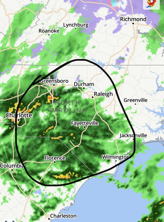
Also I’m little upset that these maps now always cut off at short pump instead of RVA

-
26 minutes ago, H2O said:
I just think it could be a little more directed. Call them out like you just did but in your first post. Cause it made it sound like it was more blanket and I hate being lumped in with the real debs. Thats all. I'll see myself out and not comment any more for a while.
Hope you get dumped on soon man
-
Finally got in some good rates but still can’t shake the sleet/mix. Regardless still nice to look at it and hopefully able to salvage some sledding tomorrow
-
2
-
February Banter 2021
in Mid Atlantic
Posted
Think Ji is married?