

canderson
-
Posts
23,845 -
Joined
-
Last visited
Content Type
Profiles
Blogs
Forums
American Weather
Media Demo
Store
Gallery
Posts posted by canderson
-
-
22 minutes ago, paweather said:
Get your ice picks ready
Looks like it'll still be near 40 Friday afternoon and above freezing Saturday and Sunday. Whatever sticks probably will melt quick.
-
 1
1
-
-
That huge rain dryslot working its way into the LSV reminds me of how this season has gone lol
-
24 minutes ago, pasnownut said:
really needed to look at the girl in the middle to see what she was doing. Not sure many/any women ever did "that" while stalking me....
She’s a proud Iowa State University graduate.
-
 1
1
-
-
1 minute ago, Mount Joy Snowman said:
You'll have a blast. If you don't mind me asking, where are you going and which cruise line are you using?

-
6
-
-
Got up to 63. Sweated a little in our long afternoon walk.
Going to be a rainy Tuesday and Thursday/Friday. -
60 and full sun today, rain Tuesday, sun and newer 63 Wednesday, cloudy and 38 Thursday before precip arrives, and Friday will be in the mid 40s. I’ve seen this rodeo - a solid nonevent (accumulation wise) for anyone in the LSV. We never ever win with this setup. But maybe we’ll get a nice snowglobe look!
-
1
-
-
Monday looks niiiiice. Sunny and 60.
This late week storm looks like a nothingburger in the LSV due to temps. Maybe some sleet/snow mix but mostly all rain - it’ll be warm and nothing will stick regardless.
-
1 minute ago, Bubbler86 said:
Euro is still mostly a nothing burger for the LSV. A very slight improvement from 0Z if looking for LSV ice. Mostly rain or light/borderline too warm frz. Concentrates the ice storm in Northern PA.

My guess is we getting most rain and maybe a little sleet. Another stork wheee warm arm rushes in quicker than precip - the tend all season.
-
29 minutes ago, MAG5035 said:
I had to leave for the day right after the snow squall ended this morning, which best estimate I could get was about an inch. This apparently happened at 336pm this afternoon and it came with a 40.3mph sustained.
Attn: @canderson lol
Damn you win lol. My highest was 49. It’s really calmed down in the past hour - gusts now just in the upper 20s.
-
Appears a gust knocked out KCXY - my highest so far has been 49.
-
10 minutes ago, Voyager said:
When the squall hit. This is the 10 minute video I shot timelapsed down to 2.5 minutes...
Fun video! You got better stuff than we did. Also the truck at 55 seconds looks like it’s going 95 mph down a city alley!
-
1
-
-
3 minutes ago, Bubbler86 said:
We have sustained 35, gusts over 50 right now.
It’s so cold and windy Fetterman was wearing long pants and a real coat.
-
Just now, Atomixwx said:
What were you protesting?
No protest - was a rally some local educators held to drum up support their upcoming unionization vote.
-
Just got home from standing outside at the capitol for an hour - holy god is it windy.
-
Put down a real nice coating of snow on all non paved surfaces. Still snowing but much lighter now.
-
Visibility is down to half a block. That’s an official NWS measurement, right?
-
Squall is here. Major wind too.
-
Got a 2 pm rally to attend at the Capitol - this should be an adventure.
-
As expected, wind headlines up for tomorrow for the entire CTP coverage area.
...WIND ADVISORY IN EFFECT FROM 9 AM TO 7 PM EST SATURDAY...
* WHAT...West winds 15 to 25 mph with gusts up to 50 mph
expected.* WHERE...Portions of central Pennsylvania.
* WHEN...From 9 AM to 7 PM EST Saturday.
* IMPACTS...Gusty winds could blow around unsecured objects. Tree
limbs could be blown down and a few power outages may result.
Blowing snow will reduce visibility and cause poor travel
conditions during and after snowfall.* ADDITIONAL DETAILS...Snow showers are expected and dangerous
snow squalls are also possible, mainly north and west of
Interstate 81. Blowing snow and reduced visibility can be
expected during and after snowfall. -
CTP might need to reissue wind headlines for tomorrow and tomorrow night. Looks just as windy if not moreso than last night and today.
-
1
-
-
Have had multiple 40+ mph gusts since 4 a.m. Peak is 53 mph. Sustained currently at 28 mph.
-
2 hours ago, Anduril said:
We lost power just before the front roared through around 330ish and then it was a gail. Some pretty impressive bursts of wind since then as well. I think our garbage can might be over the river...
I'd take a look but I would be blown across the river myself.
-
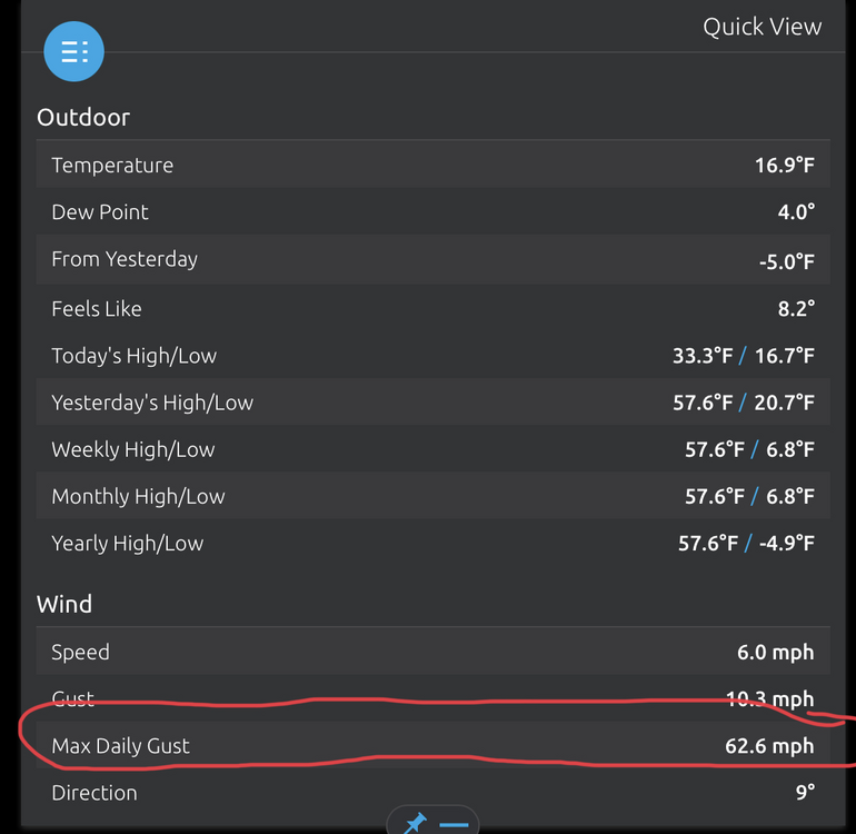
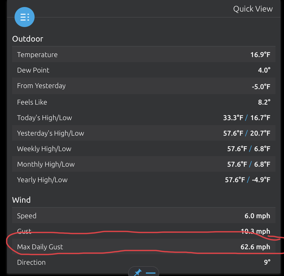
This baby threw down a 53 mph gust Still gusting high minutes after it’s passed
-
Line woke me up - thunder, insane wind.
Central PA - Winter 2021/2022
in Upstate New York/Pennsylvania
Posted
63. Birds are singing loudly this morning, first time I can recall since the fall.