

backedgeapproaching
-
Posts
3,771 -
Joined
-
Last visited
Content Type
Profiles
Blogs
Forums
American Weather
Media Demo
Store
Gallery
Posts posted by backedgeapproaching
-
-
7 hours ago, Ginx snewx said:
You really are in a good snowy spot.
For a SVT valley location it is pretty decent as some spots can not be (DDH, etc) Retention obviously is not great--but it's bad anywhere west of the spine up and down VT. 1500ft and up on the East Slope would be the ideal spot.
-
1.1" on .07" LE
-
Coming down nicely with some good snow growth..looks like maybe .5" down. Couple inches would be a win tonight for here.
-
 1
1
-
-
7 minutes ago, dendrite said:
Kenny G and The Rippingtons while waiting for the hourly current conditions update around the top of the hour. The music of my childhood.
And you always wanted to see the big snowflake in the extended forecast (obviously the current conditions too).
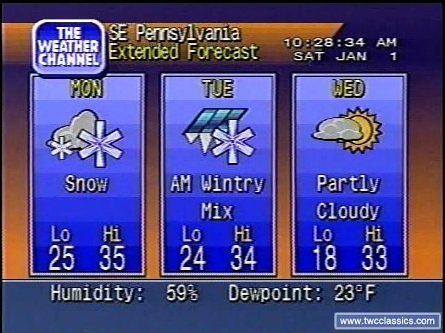
Tuning in just praying for that double snow icon..They had a different one for "Snow" before that one I think.
-
1
-
-
3 hours ago, CoastalWx said:
That was more organized than this will ever be. NGM was the more aggressive model. 16” fluff at my locale now from that.
Looks like a little more than just a innocuous clipper:
Deform right over Boston
-
Mitch taking an substantial early clubhouse lead season to date, still plenty of holes to be played though
")

-
11 minutes ago, Ginx snewx said:
Bob Maxson NBC 30 Ct
29 spot in Greenville, so seems plausible

-
2
-
-
1 hour ago, mreaves said:
Had 4" on the deck this morning. There was less here at work in Montpelier and a colleague coming in from the Morrisville area said there was reall nothing until she got to just outside Montpelier. I was sort of surprised. It wasn't snowing when I went to bed at 11:00, the forecast didn't call for anything and everything indicated that the storm was starting to crank further east. A little bit of a positive bust for my back yard.
Some of the meso models last night were backing a band up near your area around 12am or so, always nice to wake up to a surprise.
Total here is 13.6" after some fluff last night in that same banding that was hitting Albany area. Missed out on the jack area to the south, but can't complain for early DEC.

-
9.0" as of noon. Missed the big stuff, but nice and wintry again. Been gusty at times here on the Western slopes. See if we can somehow squeak out a few more inches later today tonight to get 12"
Interestingly, had almost exact same total and precip at 7am as the Peru COOP at 1700' up the hill.
8.3" with .76LE here
8.3" with .79LE at Peru COOP
-
55 minutes ago, powderfreak said:
Already nearing 20” in spots just northwest of Albany.
Malta in Southern Saratoga County with 20”. Rotterdam with 18”, Glenville with 17”.
And it all looks like dense snow. No fluff.
27" Duanesburg NY (west of ALB)
Albany revenge tour continues. Bunch of biggies past few years.
-
1
-
 1
1
-
-
1 minute ago, Logan11 said:
Woodford had 19" as of a few hours ago.
They always get 2ft in every storm...
That is pretty much right in line with the Bennington reports(from my plow guy who lives there) and Mitch. Pretty much 10-20" in that zone...with more to come.
-
4 minutes ago, HoarfrostHubb said:
Weir Lundstat felt the 14” at the base of Mt Snow was legit
For Sure, Mt Snow is the most south of all SVT resorts.
-
1 hour ago, PowderBeard said:
That's wild. 8-9" at Mount Snow on the cam but they are reporting 14", Stratton reporting 11", Magic at 8".
The Stratton and Magic numbers sound right. That intense WCB banding never quite made it past extreme SVT. They even had 10-16" in Bennington VT from what I hear-the snowhole of the state.
-
Smidge over 5" here now. 22F and has been coming down nicely for a few hours, dense powder consistency. A little too far north in SVT I think to get in on the super S+ happening in ALB and near Mitch.
First plow of the season needed on driveway. 12" would be high max here I think if everything broke right.

-
2
-
-
Heading back home a day early today to get ahead of whatever this turns into.
Always room to adjust up if needed

-
Out of town, but also hearing about some big time boomers rolling through SVT.
-
Decent size bust in SVT...nowhere had more than a few inches. Saw Mitch had 3"..think that was probably the max in all of SVT.
Peru Coop at 1700' only reported .8". Stratton only 2". Warm nose and not a lot of total QPF (outside of the VT/MA border where they had closer to a 1")
Had .7" here after the flip last night, never even flipped below 800' in town--rain only.
-
8 minutes ago, Lava Rock said:
this area actually has quite a bit of soil/sand as the area directly below my weather station is the septic leach field. Of all places where the grass should grow well, yet it doesn't. I mentioned before about rototilling this mess in Spring and reseeding, but the risk is constant sun and without daily watering for weeks on end, it would probably burn out before it got well established. It would probably be best to wait until Fall, but having to look at this all next Summer is painful.
I know its been along battle, not sure what is going on there. You have some clumping green grass--mostly likely some type of Fescue, but could also be some undesirable grass for a home lawn like Orchard grass, but at least its green.
I just looked again at that pic from May you posted a few pages back, I dont know why it didnt bounce back in the fall? Does it do this every year? When was it seeded?
-
3 minutes ago, #NoPoles said:
Looks like the forecast has changed a bit. It had rain on Wednesday and some passing snowshowers for Thursday. Now the forecast is leaning towards frozen stuff on Wednesday and snow on Thursday...
How did you make it in the event yesterday? Hopefully the few hundred feet you are lower than Alex didn't affect accum.
-
42 minutes ago, redbanknjandbigbasslakepa said:
I think at your elevation you’ll do much better. I’d expect a good 8-12” at Searsburg Pass.
That's aggressive with modeled warm nose and being that far south and east near the VT/MA line. It would really have to rip once all levels cooled. Definitely a tricky forecast.
-
Couple tenths here tonight as some orographic snow kicked up in the past hour
-
6 minutes ago, alex said:
I find you need some really strong winds for it to matter. In most cases the difference is not very noticeable until you get to Whitefield or towards Littleton
Right, as PF mentioned your tucked in close, similar to me with the greens, so not as much distance for the downslope waterfall effect. Where is Nopoles, i guess a little further out?
-
RGEM is interesting, nukes this little sucker CVT/NVT up through NH and NW Maine.
ALY totally MEH on this event in their AFD
-
16 minutes ago, #NoPoles said:
SE is downslope here?
Just looking at the topography looks like downsloping from S, SE, E. As you and Alex know though you can reap the rewards on the Nw/N upslope flow.
HIE is known as the one of the biggest SE downslope pits I believe. Look at every 3k nam precip map, you could have March 93 redux coming up the coast and I swear it would print out .25" qpf for whitefield. It does the same for DDH, always a ridiculous minimum in any SE flow event. A bit overdone, but you get the idea.
-
1
-


NNE Cold Season Thread
in New England
Posted
Nam gone wild with the clipper tom in SVT/CVT: