

BombsAway1288
-
Posts
1,376 -
Joined
-
Last visited
Content Type
Profiles
Blogs
Forums
American Weather
Media Demo
Store
Gallery
Posts posted by BombsAway1288
-
-
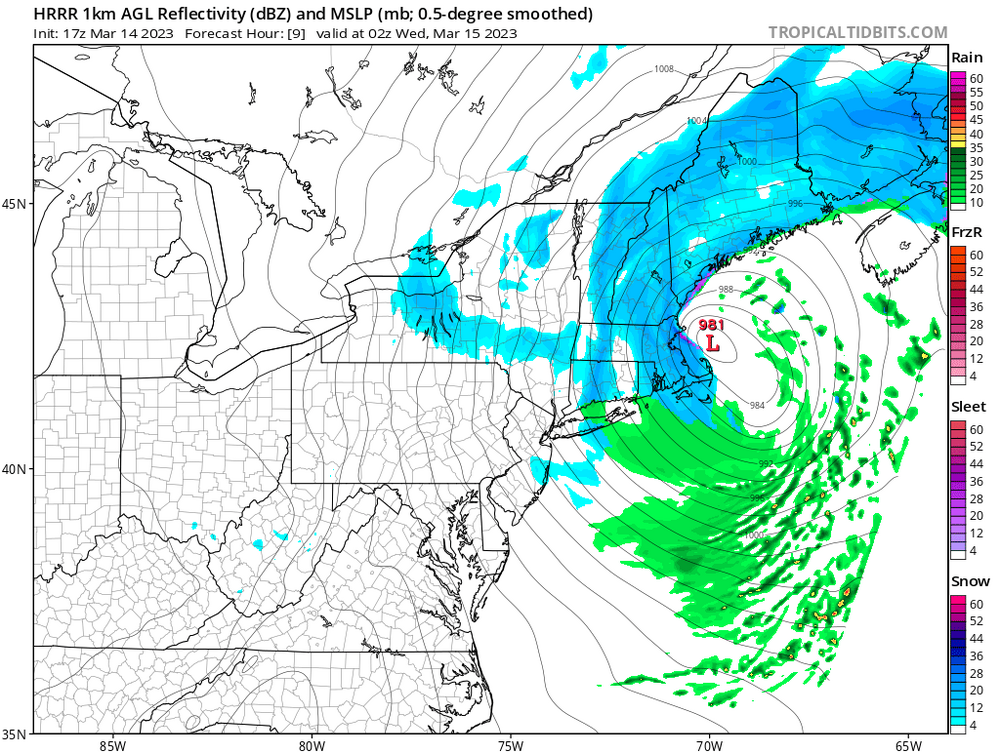
Another underperforming aspect of this has been the wind. Been pretty pedestrian so far away from immediate beaches but probably because the storm is just bombing out now so I’ll hold out hope until later.
-
21 minutes ago, wkd said:
If people would look at the "total positive snow-depth change" instead of the 10:1 total snowfall maps their expectations would be more realistic.
It wasn’t about taking the 10:1 maps verbatim in a marginal setup like this, at least I wasn’t. It was about the constant rates that never materialized in the early afternoon like muddy said. Models didn’t show the dryslot getting this far north. 6+ on the coast was always going to be dependent on heavy rates after the flip and going to town for hours. That never happened
-
 1
1
-
-
8 minutes ago, Massplow said:
What are the chances we get some accumulation on asphalt in the Sharon/Mansfield/dedham areas. Have a full crew of plow drivers and shovelers and dont know what to tell them at this point
Probably nothing. Anywhere south of the pike is probably cooked
-
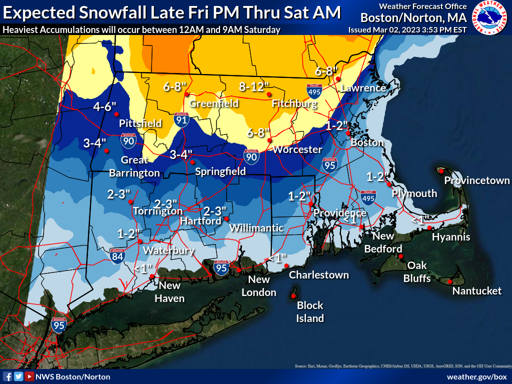
That BOX map will bust bad in BOS and probably most of eastern mass. Maybe an inch or 2 if everything comes together right but certainly not 4-6
-
 1
1
-
 1
1
-
-
2 minutes ago, KoalaBeer said:
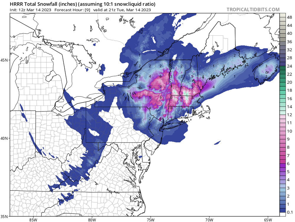
Has it really been that bad though? Honestly I haven’t paid a ton of attention but this is the 12z run from this morning valid 21z today showing 1-2 inches max for Boston at 10:1 which we knew to toss those ratios anyways…
It was mostly right that run but that’s because it showed a low amount of snow EMA.
You know damn well now that it shows 6”+ over the same area it will be wrong. Winter 22-23 -
Band south of BOS is shutting down and another mega dryslot is coming in off the ocean.
This whole CCB thing is really working out well -
9 minutes ago, KoalaBeer said:
HRRR gets going down there for a while later today through this evening. Willing to bet they get 4-6.
 7 minutes ago, MuddyWx said:
it's been wrong all day in this area :/
Couldn’t get a 6 hour forecast right. How can this be trusted?
That ain’t happening. Not this winter at least -
2 minutes ago, weathafella said:
Over/under on BOS getting measurable?
Under. White rain/snow mix until sunset then Gradually tapering showers.
Awful performance by mesos outside of higher terrain -
10 minutes ago, Ginx snewx said:
Euro run out of Ray's basement

Obviously overdone a bit NW of 495 waaay overdone 495 SE. that has 0 shot of verifying the way radar looks now
-
Gotta think the O/U for Logan in this is 6”? If that CCB gets cranking it should stack up decently fast. Def good trends towards that last night
-
38 minutes ago, RikC said:
Yup, BOX upgrades BOS NE to warnings. Guess they’re finally buying the CCB in the afternoon.
Hoping for a few hours of blizzard conditions before it gets dark -
1 hour ago, 40/70 Benchmark said:
It is. Get a clue.
I mean storm wise sure, but major snow amounts aren’t happening in eastern sections like implied.
48 hours out was way too much time to be so sure especially when everything has been so inconsistent.
If that idea reverses in the next 2 cycles then major credit to you. Hope it does -
Looks like somebody went waaaay over their head last night with definite statements like “severe storm” and “big one” for EMass. Not even close lol
-
1
-
-
Coast is toast with this. Hugger=rain. BM=rain
-
 1
1
-
2
-
-
Great so the 1st wave is too suppressed and the 2nd is a hugger and congrats interior. Sweet! I think the coast is toast. Can’t win a single thing this winter
-
 1
1
-
1
-
2
-
-
It’s always a week away. Last Saturday they were honking for this Saturday and everyone was getting excited. Now it looks like the better chance is next Wednesday. Usually never works out when that’s happened all season. Always a week away….
-
1
-
1
-
2
-
-
32 minutes ago, WinterWolf said:
I don’t think we know a whole lot yet. If anybody thought this was gonna keep a big dog look for 6-7 days, they were on shrooms. We’re approaching the mid range and it’s doing what always happens…it’s trying to figure out what ultimately happens. It could comeback to something major, or it could follow the tenor, and deamplify to nothing.
Things are evolving and trending, and I honestly don’t think we know how this ultimately plays out yet, and what wave becomes dominant, if any?
Thing is I think we all really know how this is eventually gonna play out. Something in the atmosphere will stop this storm from becoming reality. It has all season so there’s no reason to think otherwise
-
5 hours ago, George001 said:
That’s the goal, while being a weenie is fun sometimes constant wishcasting doesn’t really contribute to the discussion. Nobody wants to hear “blizzard incoming” and get a few inches of slush a couple days later. I’m starting to find that it’s more enjoyable to track when I’m actually being realistic and objective. Just because a couple runs of the gfs had a Miller B with 12+ inches of snow and no mixing whatsoever for my area doesn’t mean it’s time to start calling for a blizzard. A lack of high pressure to the north and east or southeast winds ripping over us at the height of the storm doesn’t exactly scream big snow, regardless of what the clown maps say.
Heeeey. Now there’s a sensible post. Glad to see you’ve changed your tune. That’s all I/everyone else asked. Good stuff
-
28 minutes ago, MJO812 said:
Euro!
Euro control!
I thought we were supposed to just follow the ensembles?
12z will be back over Detroit, guaranteed. -
4 hours ago, MuddyWx said:
Yikes! And just like that there goes that “great look”. It’s ovah!
-
1
-
-
Barely anything in Chelsea/DT Boston. Maybe and inch of slush. Changed over to rain/sleet around 3am.
What’s the deal with the CCB? That would be only way BOS can add to this otherwise Logan will report less than a inch-
1
-
-
1 hour ago, HoarfrostHubb said:
Would love to know what model the Wunderground app is mostly based on for their app snowfall algorithm. Has me at 8-12 tonight and 3-5 tomorrow. GFS ?
Wondering the same thing. Has me for 6” here. I’ll believe it when I see it.
It did do very well on Tuesday FWIW
-
6 minutes ago, 8611Blizz said:
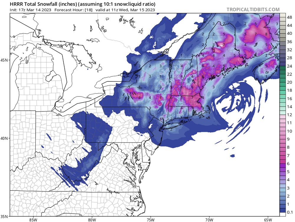
BOX upping the totals for some area's but not buying much improvement for the coastal area.
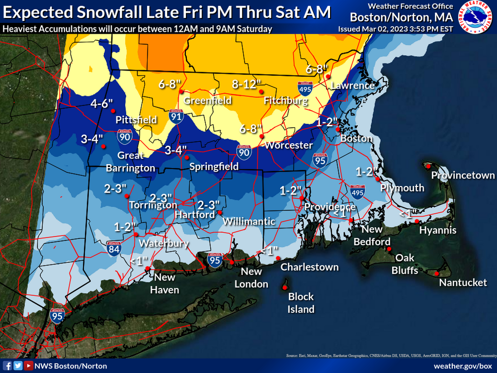
Gotta think it’s gonna end up at least double that for BOS especially coming at night but I get the conservative approach for now
-
Bust here for sure. Maybe an inch early on but raining since mid morning and all washed away.
Only the solidified ice pack from last Thursday remains


Last Hurrah Obs Thread: 3/13-15/23
in New England
Posted
Can’t believe BOX still has a warning up for Suffolk and eastern Essex. They need to drop that asap