

BombsAway1288
-
Posts
1,428 -
Joined
-
Last visited
Content Type
Profiles
Blogs
Forums
American Weather
Media Demo
Store
Gallery
Posts posted by BombsAway1288
-
-
NHC giving in.
Major shift west on track.
Almost all of NE is in the cone now
-
 1
1
-
-
3 hours ago, LibertyBell said:
well to be fair at least he posted the ensembles this time lol
The charts are bad, period. Whether it's the ensembles or the op, the algorithm that makes up the chart is severely messed up or something as another poster pointed out earlier.
-
2 hours ago, CIK62 said:
This is the GFS ENS., so some of the extremes might be muted out, but no BN days here:

Why do you keep posting these? They're waaaaay off and not even off by a little bit. I've seen day 1 forecasts that are a solid 10 degrees too warm. Garbage.
-
2
-
 1
1
-
-
1 hour ago, AmpedVort said:

Your posts are nonsense.
I mean posting and deciphering 488hr CFS forecast maps and finding eye's in invest's? Really?
I advise you to come back to earth and post some logical things before you're not allowed to post anymore period.
-
2
-
-
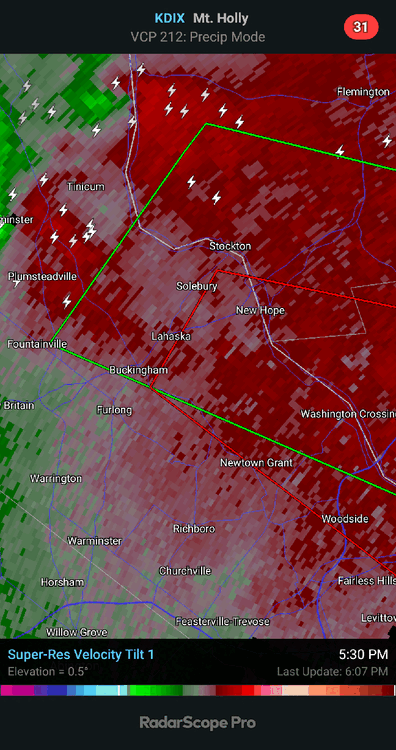
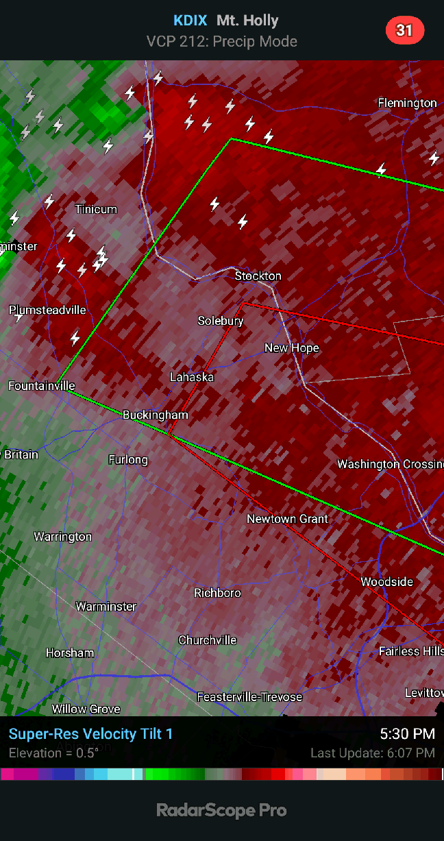
2 minutes ago, Stormlover74 said:
Tornado warned again
If that's not a tornado on the ground right now then idk what is
-
The couplet over Ocean County is absolutely insane.
I've never seen anything like that in NJ before. Insane
-
3 minutes ago, HailMan06 said:
This aged well
It was pretty meh north of Rt. 80 tbh.
Some models had this blowing up in NYC/NE NJ through 10-11pm. Unless there's serious development on the backside, looks like most of it is through by 8pm
-
Maybe starting to weaken?
Heading for SW Monmouth County now
-
4 minutes ago, Rjay said:
Rotation looks broad now. I don't think it's still on the ground. Could be cycling.
You're spot on.
Think it's cycling back up now, unfortunately.
-
2 minutes ago, Rjay said:
Large debris ball with that one.
Mercer County needs to take cover now.
-
1
-
-
Pretty good rotation showing up over Bedminster.
Heading for Monmouth County eventually
-
2 hours ago, CIK62 said:
And remember the GFS is +4 to +7 in the LR around these parts: (I got to 91* ultimately today and beat Central Park.)

Those are really the numbers the GFS is spitting out for NYC? The next 2 days don't jive, 88 degree low for Central Park? And if that's saying that 88 is the low just before midnight tonight, well it's 87 now so that's way off. Unless I'm reading it all wrong of course.
Also, grossly overestimating the highs. KNYC's reporting hotspot of KLGA was 3 degrees under what this is spitting out, let alone Central Park.
What am I missing here?
-
1
-
-
1 hour ago, Snowlover11 said:
meh congrats who got hammered, guess we will see later on if anything comes thru

Don't ever expect storms to hold together as they approach NE Bergen County/ Southern Westchester-Northern Bronx.
If you're in Yonkers, you're literally 1 mi across the river from me so pretty much the same weather and constantly watch storms break up/weaken as they approach the area. It's like a storm graveyard and very frustrating all the time even though we have all the ingredients.
We'll see how they act later.
-
1
-
 3
3
-
-
5 hours ago, Brian5671 said:
Flash Flood watch up for much of the area now
Last time they hoisted FFW 24hrs in advance it failed miserably. They're the pro's so I guess time will tell.
-
Fully expect temps to beat guidance all week as usual
-
3 hours ago, bluewave said:
In the opposite direction, this was the 5th coolest July daily maximum temperature at LGA. None of the top 5 had a 100° day occurrence near the date. The closest would be 1941 but it came up just short.
Almanac for LAGUARDIA AIRPORT, NY
June 30, 2021Daily Data Observed Normal Record Highest Record Lowest Max Temperature 100 85 100 in 2021 66 in 1967 Almanac for LAGUARDIA AIRPORT, NY
July 3, 2021Daily Data Observed Normal Record Highest Record Lowest Max Temperature 67 86 107 in 1966 67 in 2021 Time Series Summary for LAGUARDIA AIRPORT, NY - Month of Jul
Click column heading to sort ascending, click again to sort descending.RankYearLowest Max TemperatureMin Max Dates1 1978 62 7-4…62…7-6….85 - 1956 62 7-6….62…7-2…94 2 1941 64 7-4….64…7-2…98 3 1972 65 7-5…65…7-2….72 - 1964 65 7-9….65….7-1….97 4 2005 66 7-8….66…7-11….92 5 2021 67 6-30…100….7-3…67 - 1961 67 7-15….67…7-18…89 Can you provide a link to where you find this info? TYIA
-
8 minutes ago, SnoSki14 said:
Yeah I'm gonna say hell no to the multi 100F readings.
Does it have any credibility?
What the euro numbers showing?
-
Did Central Park make it to 51 today? Saw the hourly reports no higher than 50 but wondering if it made it to 51 between hours to tie the record.
@donsutherland1 What other record low max's were set today in the NE?
-
20 hours ago, jm1220 said:
If Boston measured officially from Fenway Park Central Park would probably be beat by 10” or more. 2/1 screwed them over big time from the onshore flow. The storm wasn’t matured enough at our latitude to screw us over that bad.
That one was one of the craziest gradients I've ever seen.
Went from white rain and a slushy 1" of accumulation at the water to over 18" not even 5 miles inland.
You guys got hammered. Brother in NNJ reported close to 2 feet!
-
Sounds like this is heading toward a whole lot of nothing in the end.
On to warmer things.
-
41 minutes ago, IowaStorm05 said:
So you guys think this could be it?
In terms of long term cold/wintery pattern, this is probably it. Nothing exciting to finish out February.
March can def deliver a blockbuster storm (I have no idea what the indices are showing for it though) but in terms of long deep cold, snowpack sticking around etc... yeah it's probably done on that level. But hey, I'm just an amateur
")
-
1
-
-
3 hours ago, wxsniss said:
A subset of SNE totals... generally 4-7" ORH east:
KBOS 5.7 / East Boston 6.5 / Charlestown 7.1 / Dorcester 7.0
As many expected, jack was Milton 7.3:
...Suffolk County...
  Charlestown             7.1  1127 PM  2/19  General Public
  Dorchester              7.0  1113 PM  2/19  Ham Radio
  West Roxbury            6.8  1031 PM  2/19  Ham Radio
  East Boston             6.5  1045 PM  2/19  General Public
  Roslindale              6.0  1010 PM  2/19  Public
  Logan AP                5.7  1215 AM  2/20  Airport
  Chelsea                 5.6  1105 PM  2/19  Trained Spotter
  Allston                 5.4  1140 PM  2/19  Broadcast Media
...Plymouth County...
  Whitman                 7.2  1237 AM  2/20  Trained Spotter
  Rockland                6.0  1100 PM  2/19  Trained Spotter
  Middleboro              5.1  1158 PM  2/19  Ham Radio
...Norfolk County...
  Milton                  7.3  1121 PM  2/19  Trained Spotter
  Westwood                7.0  1000 PM  2/19  Public
  Weymouth                6.6  1144 PM  2/19  Public
  2 W Walpole             6.0  1218 AM  2/20  Public
  Walpole                 5.5  1000 PM  2/19  NWS Employee
  Sharon                  5.5   827 PM  2/19  Trained Spotter
  Randolph                5.3  1030 PM  2/19  Trained Spotter
  Millis                  5.0  1002 PM  2/19  Trained Spotter
  Foxboro                 5.0  1133 PM  2/19  NWS Employee
...Worcester County...
  Northbridge             6.0  1053 PM  2/19  General Public
  Fitchburg               5.1   920 PM  2/19  Co-Op Observer
  Lunenburg               5.1   918 PM  2/19  Trained Spotter
  Worcester               4.9  1028 PM  2/19  CWO
  Worcester AP            4.9  1216 AM  2/20  Airport
...Barnstable County...
  Marstons Mills          4.7  1244 AM  2/20  Ham Radio
  west harwich            3.8   416 PM  2/19  Ham Radio
  Barnstable              3.6   855 PM  2/19  NWS Employee
...Essex County...
  Topsfield               6.0   952 PM  2/19  Public
  Peabody                 5.5   830 PM  2/19  Public
  Swampscott              5.0  1000 PM  2/19  Public
  Ipswich                 5.0   951 PM  2/19  Trained Spotter
...Middlesex County...
  Wilmington              6.5  1151 PM  2/19  Public
  West Newton             6.2  1107 PM  2/19  General Public
  Framingham              5.5  1027 PM  2/19  General Public
CONNECTICUT

...Hartford County...
  Burlington              4.5   802 PM  2/19  Trained Spotter
  Collinsville            4.0   853 PM  2/19  General Public
  South Windsor           4.0  1112 PM  2/19  Trained Spotter
  North Granby            3.7   756 PM  2/19  Trained Spotter
  West Hartford           3.5   853 PM  2/19  Broadcast Media
RHODE ISLAND

...Kent County...
  TF Green AP             6.7  1215 AM  2/20  Airport
...Providence County...
  East Providence         4.5  1000 PM  2/19  Public
  Providence              3.0  1100 PM  2/19  Public
Boooo! KBOS should of been 6".
Maybe they were throwing the NWS a bone by not having a WSW end up verifying

-
20 minutes ago, wxsniss said:
Hard to see how KBOS is not over 6" given 4.5" at 7pm and best returns of the event 8-10pm...
What a fun event. Not a blockbuster, but still had its own charm.
Guidance was actually pretty decent... we were guarded after Tuesday's debacle but guidance actually verified pretty well.
The other thing that threw people off: Euro was simply not good on this. Not a good winter in general for it.
Robust solutions on GFS / UK / RGEM proved correct in handling the reinvigorated low Thurs-Fri.
Just looking at 12z Wednesday guidance... best guidance:
NAM, RGEM, GFS, UK
GFS father > v16, though too robust in northeast MA up into southeast NH/ME
I think it does.
6.5" final here and I'm basically next to Logan.
-
36 minutes ago, dmillz25 said:
Visiting family and friends. Snowfall in Boston is beautiful imo
It really is. No city like it with snowfall.
Picturesque and pure New England.
Very happy I moved here even though NNJ wasn't that bad either.

August 2021
in New York City Metro
Posted
Well said.
This might be a landfalling TC somewhere in the Northeast but it won't be a super strong/windy system.
Will also be likely weakening upon approach