

BombsAway1288
-
Posts
1,428 -
Joined
-
Last visited
Content Type
Profiles
Blogs
Forums
American Weather
Media Demo
Store
Gallery
Posts posted by BombsAway1288
-
-
1 hour ago, snowman19 said:
You’re so stupid it makes me angry. Are you naturally this dumb or did you have to take a class?
No. Just seen your posts throughout the years.
I think most would agree. Done.
-
 1
1
-
-
1 hour ago, Typhoon Tip said:
Woah woah woah... c'mon now. To be fair, no model is handling this progressive wave tumbling pattern very well. The Euro did something similar at 240 hours just 4 or so cycles ago, having Indian Summer balm ... to runs later, gone. It's not a GFS sucks thing - either - when you are talking about Nov 25... I mean, that can't possible be a rationally fair metric - folks probably shouldn't be looking at that range if they are using that against performance - just being fair.
I would just ignore everything that guy says.
He's a known troll in the NYC forum and is 5 posted because of it.
Just posts in here to shit on Anthony or cause some 300hr+ GFS run shows a ridge while most have been talking cold and snow. Anything to go against cold and snow.
-
 1
1
-
2
-
-
10 minutes ago, donsutherland1 said:
2011, 2012 and 2020 were cold. 2020 had the coldest mean temperature (39.0F) since 1925 and the 2nd coldest on record.
Thanks. Of course the temp difference could of been a result of some colder years and not necessarily a warm 1980's.
2011 and 2012 were the super cold years after the October snowstorm and Sandy respectively, I think
-
 1
1
-
-
7 minutes ago, donsutherland1 said:
A warmer than normal Halloween will conclude a warm October in which many locations in the region will see their warmest monthly minimum temperatures on record for October.
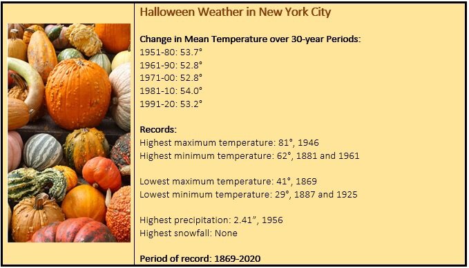
Interesting that the mean temp for 10/31 went down in the most recent set of averages. Must have been some warm Halloween's in the 80's.
-
28 minutes ago, nycsnow said:
Ida rain did more damage in nyc then 50mph winds would do and city was back within 2 days. Some wind would really make this a high impact event with just a few inches of rain it’s not a major impact event there’s not gonna be ida rain amounts
Wind threat wasn't there with Ida, just copious amounts of rain in like a 4 hour period. If the winds deliver on this one there will be tree problems, maybe not so much in the city cause its the city but in surrounding suburbs where there are more trees then there could be problems
-
1
-
-
2 minutes ago, nycsnow said:
Halloween wouldn’t be cancelled from 50mph winds imo
It would from tons of uprooted trees but there would probably be enough lead time to restore order by Sunday
-
1
-
-
1 hour ago, David-LI said:
Based off 12z NAM, most rainfall occurs overnight tonight into tomorrow. Winds don't seem to be very strong until late in the evening tomorrow as the low pivots back.
If the winds are really that strong we run the risk of numerous power outages thanks to freshly saturated ground ala March 2010
-
1 hour ago, LibertyBell said:
You're not supposed to have this in October, October is historically the sunniest month of the year. This is a spring time pattern (or November pattern)
Is it really? That doesn't sound right.
-
On 9/3/2021 at 2:44 PM, donsutherland1 said:
Revised to include 9/1:
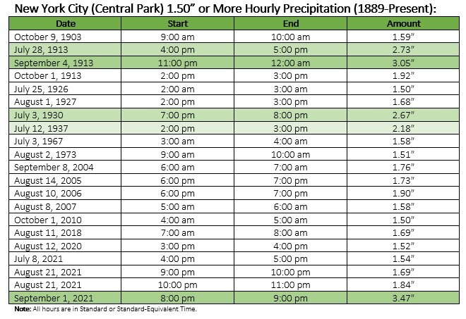
Pretty amazing that 3 of the top 6 amounts happened within basically a 2 month span in 1913 on all separate events.
-
1
-
-
Just now, tamarack said:
Lot of NJ transplants in this sub-forum. We came to Maine in Jan. 1973.
Yeah there's tons of us. Must be the most of any state outside of New England.
-
32 NJ transplant (and die-hard Yankees fan) who's back and forth for work.
Winter's are spent up here though
")
-
10 minutes ago, Spaizzo said:
That's absolutely insane.
Just your everyday stovepipe tornado plowing by the toll booths on the NJ Turnpike lol.
What an unbelievably historic day unfolding from here down to the Mid-Atlantic.
-
1
-
-
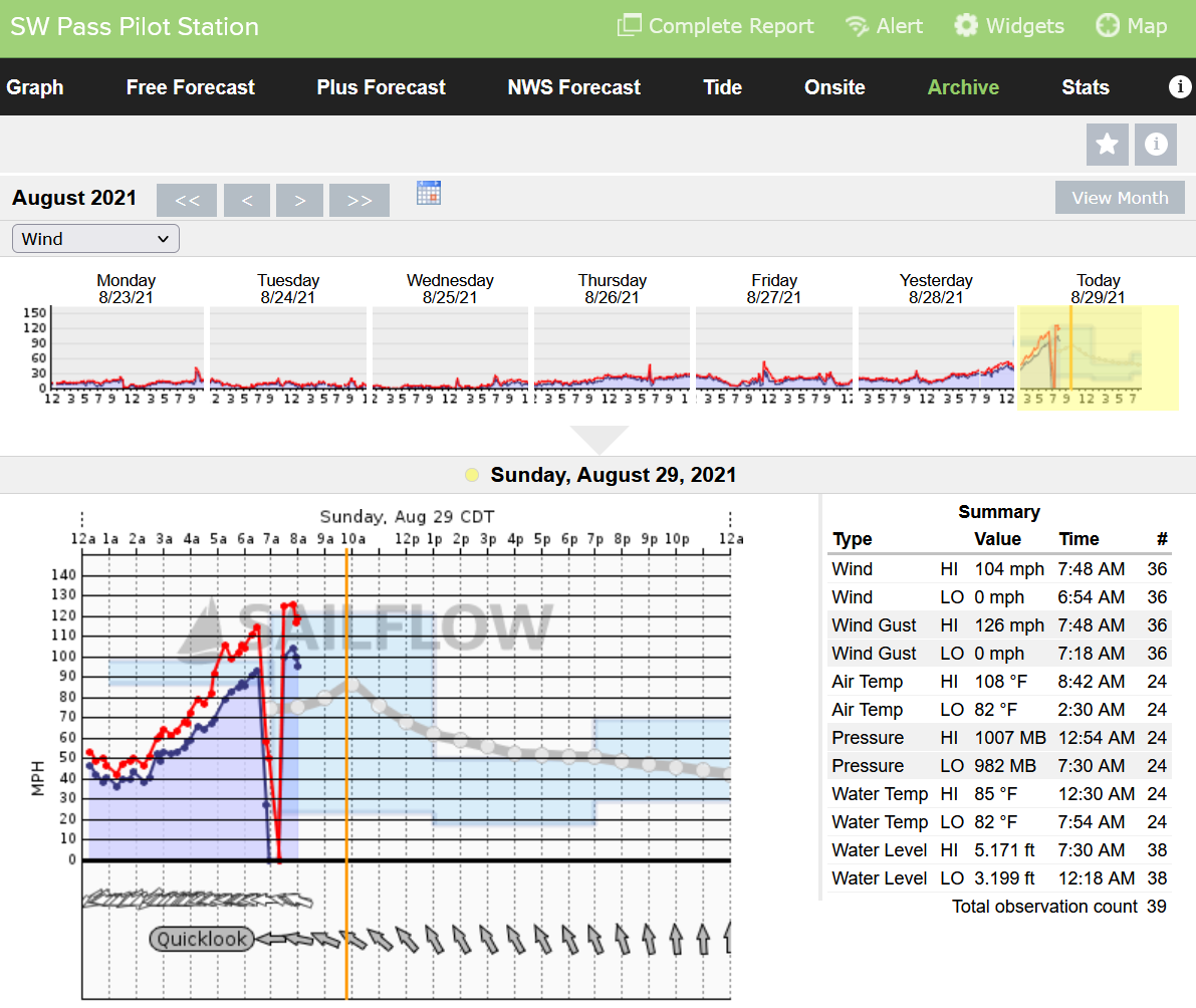
1 minute ago, wxeyeNH said:
As of 545pm east time I still have not seen any storm chaser video that is showing true high end Cat 3 conditions. I am just comparing some of the Youtube videos of past major storms. Maybe no ones position if directly under the worst of the eyewall. Reed Timmers video in Houma definitely has not shown true near white out conditions as we saw many times with Michael. Ida's radar and satellite presentation is so impressive so chasers must be just missing the inner eyewall.
The 2 tweets on the previous page were good enough for me. Truly major hurricane conditions.
Storm chasers for the most part are not going to put themselves in the extreme heart of the danger right on the coast (Grand Isle, Golden Meadows).
-
10
-
-
8 minutes ago, Prospero said:
This station went through the eye:

Pressure only got down to 982mb?
-
Anybody have a Weather Channel streaming link?
-
6 hours ago, DotRat_Wx said:
I think Boston broke all time low temp last night 84F
Didn't pull it off last night but they did tie the record max low for 8/24 with a low of 71 which tied many years, 1947 being the most recent.
KBOS broke the record max low on 8/25 by only getting down to 76 which broke the record of 74 from 1998 (was tied with 3 others from previous years).
Also, came within 1 degree for the record max low on 8/26 with a low of 75 (Record-76 in 1948). Quite the stretch!
Hopefully these will be the last high low temps of the summer. Nights are just waaaay too muggy.
-
15 minutes ago, SnowGoose69 said:
They are actually working through the storm because winds just are not strong enough. There's been several big outages 1-3K out on the E End and they've repaired them within an hour. I doubt LI gets more than 20-30K outages at this rate which means even if you somehow go out you're back probably by tomorrow at worst
Probably correct with the track shifting east as much as it did from yesterday morning.
TS winds are only what? 30 mile radius? And even then it’s inconsistent gusts.
LI was spared (wind wise) outside of the twin forks and even there it’s less cause of the east shift.
Like many, including myself have been saying, the story with this storm is the freshwater flooding and tidal flooding
-
I don’t think I’ve ever been more tempted to take a day trip to Foxwoods.
-
1
-
-
4 minutes ago, MJO812 said:
Hmon Is pretty far west this run so far

Don’t think an NJ/NYC/LI is off the table yet, especially with how far south and west it’s moving now
-
3
-
-
5 minutes ago, ineedsnow said:

They really don't move much in that 18 hrs lol, wow.
Freshwater flooding and the higher than normal tides will be the story here.
Trending in the ugly direction for a lot of people at the moment.
-
 1
1
-
-
34 minutes ago, TauntonBlizzard2013 said:
How strong?

Mainly lots of trees down and outdoor furniture being blown around.
Guess of a tornado is purely from all the tree's down.
-
Might have been a very brief tornado in Clinton.
Some of the pictures and videos coming out of there show some pretty strong damage.
-
3 hours ago, LibertyBell said:
hmmm if this storms hits eastern NE it will likely only be a TS when it gets into the much colder waters up there. It's only chance of making a landfall as a hurricane is in the tristate area
That's not true.
Could easily still make landfall anywhere between Montauk and Nantucket as a hurricane.
All options are still on the table.
-
1
-
-
2 minutes ago, justinj said:
Looks like wind not too big of a concern?
Don't think it ever was.
Surge and rain would be the story with this.


Friday, November 12, 2021 Severe Potential
in New England
Posted
3 overlapping tornado warnings right over Providence.
That's something you don't see everyday around here