

BombsAway1288
-
Posts
1,376 -
Joined
-
Last visited
Content Type
Profiles
Blogs
Forums
American Weather
Media Demo
Store
Gallery
Posts posted by BombsAway1288
-
-
Complete scalping in Chelsea with the grass getting covered. Kinda surprised honestly. Was expecting 100% rain at this point
-
 1
1
-
-
45 minutes ago, HIPPYVALLEY said:
BOX not impressed.
Burlington more bullish.
BOX has the right idea. Maybe a tad light along the border but not by more than a couple of inches. I see they’ve learned their lesson from all the bullish calls this year in marginal situations.
Anybody south of a ALY-MHT-PSM line expecting more than an inch or so of snow is going to be disappointed. It’s April. The airmass is decent for this time of the year but needs to be better for SNE
-
2 hours ago, 40/70 Benchmark said:
29" on the season with average of like 62".
Try 9” with an average of 50”. Being at almost 50% of average isn’t that bad compared to a lot of others here.
Still sucks though
-
1
-
-
21 minutes ago, Winter Wizard said:
Um?

Not sure what that’s about, an error obviously.
Scattered dustings in Chelsea. Boston metro inside 128 has got to be the lowest relative to average in all of NE at this point. Sad last couple of winters here
-
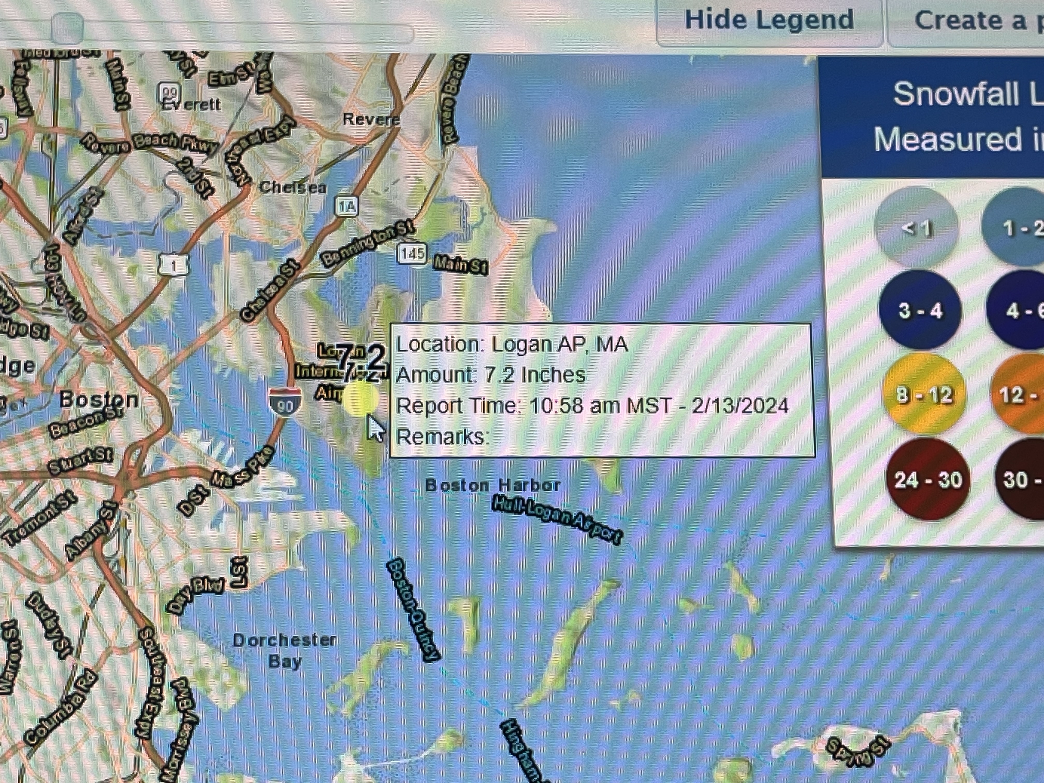
All rain Boston with a temp of 35. Logan will record 0.0 out of this
-
1
-
-
7 minutes ago, AstronomyEnjoyer said:


Wagons north. Still looking good pike region but the north ticks need to stop now. If they continue at this pace until go time it’ll be congrats rt. 2 north
-
1
-
-
7 minutes ago, NotSureWeather said:
Can you please stop posting these maps that are including a two week run? It’s a bit misleading for someone not checking the dates.
Yeah these are getting a bit ridiculous for the lead time. We really don’t need to see how much qpf an 18z run spit out for events that are 2 weeks away
-
 1
1
-
-
We’re killing it on the coast. A whole coating! I’m surprised it’s even that tbh
-
They’re on another level down there in all seasons. Consistently 90+ and humid all summer, 80’s in peak climo winter. No thanks
-
Thinking this is very similar to 1/7 for the coastal plain inside 128. Lots of white rain and frustration. It’s always something here it seems, 1/7 the ocean was too warm still, now we have a cooler ocean but crappy airmass that can’t overcome it. Congrats interior nw of 495. We now suck on the coast for snow
-
4 minutes ago, Damage In Tolland said:
Thats a pretty big shadow/ downslope area
Probably does pretty well on east flow events but gets screwed from any other direction it looks like
-
1
-
-
50 minutes ago, AstronomyEnjoyer said:
18z HRRR and 3km NAM have decided to up the freezing rain threat. Check out the FRAM estimates and the total ZR QPF on the 3k NAM. Not sure I've ever seen green show up on one of those before.


That’s going to be really bad for those areas. Those maps are almost always too bonkers but even if it’s 25% right then that’s some significant icing
-
6 hours ago, MJO812 said:
Ugggh that storm
That storm really was awful for the coastal areas of the northeast. I was only 12 y/o and in NNJ then but clearly remember the infamous snow map that the weather channel had up 1.5 days before the start of almost all of PA-NJ-SNE in purple saying 2-3 feet, locally more. Then remember that Sunday night the bust started going public with a now 3”-6” forecast, heartbreaking.
That one hurt, so did 1/05 and 1/15. Just missed in NNJ-NYC while SNE got croaked in all of them. Got our revenge so to speak in 1/16 but the pain of those others was too much and moved up here 6/17, for personal reasons too.
Sorry for the side track down memory lane. Please move to banter if need be -
3 hours ago, alex said:
That’s my actual house, right across from it. Also looking pretty good tonight.
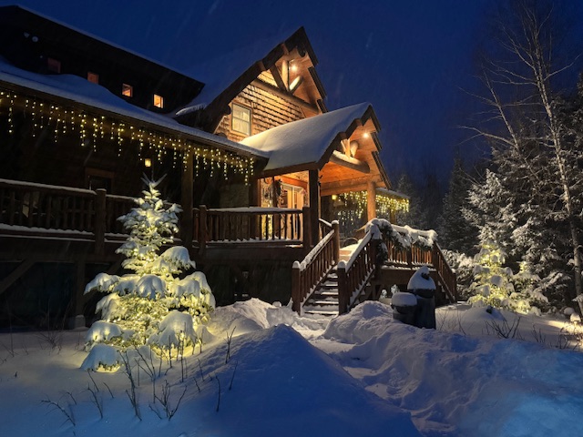
Wow, beautiful! That’s even more of a dream. Good on you for living it out. YOLO
-
7 minutes ago, alex said:
Starting to look like a winter of yore
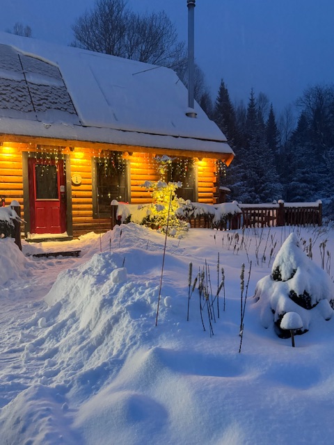 6 minutes ago, NorEastermass128 said:
@alex You, sir, are living my best life.

Yeah that truly looks like a fantasy.
You sir have an awesome house in an awesome place with an awesome job. I envy you but am happy someone here with a passion gets to live it out
-
3
-
-
3 minutes ago, STILL N OF PIKE said:
The euro , nam , hrrr and RGEM were all too mild for the N side of Boston and the 128 W and N side as well
They certainly were. This definitely exceeded my expectations with 3-4”. Was thinking a sloppy 1-2” before the changeover.
Glad the entire sub-forum got accumulating snow. It’s been a long time since that’s happened, 1/29/22 I think?
-
Back down to 30 with freezing drizzle in Chelsea. Roads were awful throughout this event until the changeover. I was driving up rt. 1 and 95 at 345 this morning and it was snow packed, no treatment whatsoever so I can only imagine how bad they’ll get again as it gets colder and colder. Seems the plows were kind of caught off guard at least with the initial thump this morning, came in very early or they were just banking on it not sticking too well
-
1
-
-
7 minutes ago, RUNNAWAYICEBERG said:
No 18z eps comment from the pros…?
I think it’s pretty obvious why it isn’t getting talked about. This place will be a ghost town after Tuesday.
Time to close the shades until February and even that should have low expectations. Fully expect an improved pacific to do nothing in terms of winter weather for the coast, it will find a way to not work out-
1
-
 1
1
-
-
1 hour ago, LSC97wxnut said:
Of course the best squall of the day comes after dark.
At least you got a squall period.
Tough crowd -
It’s snowing below 0 in northern Arkansas. That’s something you don’t see every year, this airmass means business. Wonder if it’s some sort of record for that area
-
Boston gets the 7-10 split along with Metrowest. Hopefully Tuesday delivers something to whiten things up
-
9 minutes ago, CCHurricane said:
unfortunately for southern spots, those precip types are incorrect. Soundings indicate much warmer temps.
A low riding over the cape will do that even with an arctic airmass behind it
-
4 minutes ago, Sn0waddict said:
HRRR looked closer to the NAM then it did the GFS, which probably means nothing.
You’re right, it doesn’t really mean anything. HRRR really shouldn’t be used outside of 24 hrs or even 12-18 hours.
It’s great for picking up where heavy bands will setup in an ongoing coastal, not so much a medium range synoptic system -
2 hours ago, qg_omega said:
Incredible warmth has been the story since 12/1 this winter, along with incredible amounts of rain. Classic strong El Niño winter and more warmth just a few days away.
Wrong. It’s gonna be way below normal next week and even after that the warmth might but muted
2 hours ago, qg_omega said:Looks like it, I’m not on the February is going to be great because El Nino’s are backload. Even this week’s cold has trended warmer.
I wouldn’t have expected you saying that. You really know how to spin things for your agenda. I’ll give you last year, you were correct that it was gonna be warm and snowless even though you would have predicted that no matter what but to just shit on next weeks cold and bit even acknowledge the fact that it looks like the pacific is changing just truly shows what you’re trying to do.
No changes
-
1
-
1
-


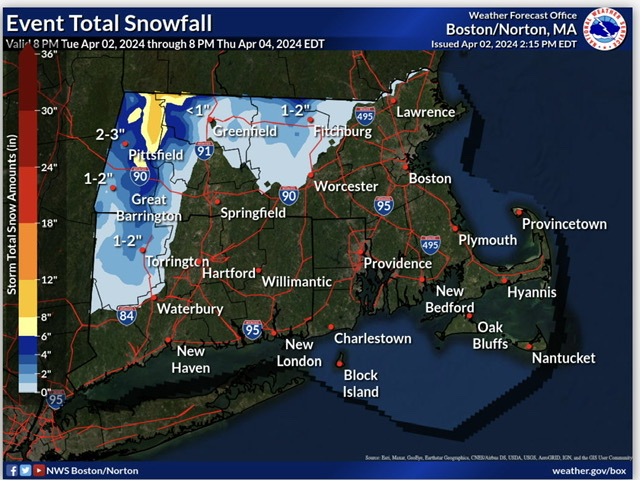
Significant Miller B Nor'easter Apr 3rd-4th OBS
in New England
Posted
Man this storm is slow to pull away. Getting the last clouds from it now.
Basically directly impacted SNE weather for 4 full days. Impressive