

Fozz
-
Posts
37,601 -
Joined
-
Last visited
Content Type
Profiles
Blogs
Forums
American Weather
Media Demo
Store
Gallery
Posts posted by Fozz
-
-
I’ll take what the GFS is showing, but only if it is not even 1 inch further north.
It’s wild how much more amped it is than 2 runs ago. Of course I don’t remotely believe it. But we seem to have a chance.
-
6 minutes ago, Ji said:
weakest noreaster of all time lol
It actually reminds me of this strung out storm from 20 years ago.
http://www.raymondcmartinjr.com/weather/2005/28-Feb-05.html
Check the surface maps… 984 low off the coast but we had snow TV all day until it finally picked up just a bit after sunset.
We should’ve gotten 12-18” but instead it was like 3-6. I think the GL low stole a lot of the energy.
-
4 minutes ago, Ji said:
amazing
What the hell gives? Is it the 987 low in the maritimes that’s stealing the energy?
-
This has to be one of the earliest ends to winter that I can remember.
-
 1
1
-
 1
1
-
 1
1
-
-
2 hours ago, nj2va said:
Today was a 10/10 late February day.
Obviously I’d much rather see a 8-12” storm but this is as good as it gets if snow isn’t in the picture.
So much better than 25 degrees and wasted cold.
-
 1
1
-
-
1 hour ago, winter_warlock said:
The way the models flipflopped on the last big storm possibility,... I dont beleive anything the models show outside of 72 hours. Showing temps 4 to 7 degrees below normal would be nice in January but 4 to 7 degrees below normal For March 8th isn't all that cold.. especially with that march sun angle lol
March 8 can be pretty cold if -5 anomalies are timed with a storm.
Now if this were April 8, then yeah we’d be finished.
-
On 2/21/2025 at 1:48 PM, spud said:
Hi! Long time lurker here. I have a snowball that has been in my freezer since 12/25/2002. My daughter made it and it seemed like a great thing to save at the time. She is all grown up with her own kids and surprisingly doesn’t want it, lol. Sooo, is there any science or other reason to save this? It was a great looking snowball one time.

You might be the only person alive who still has a piece of winter 2002-03 in your possession. Hold on to it as long as you can.
-
 1
1
-
-
4 hours ago, CAPE said:
Probably, but there is always a chance for a fluke, especially in March. The thing is, we probably see some -NAO action develop again, but not until late March/early April when it is completely effing useless, unless you want cold and damp at that point.
I wouldn’t write off late March completely (depending on location) if we somehow end up with a great setup, but by then it will be a race against time and every week will count.
In the past 12 years I’ve seen a total of at least 3 solid accumulating snow events after March 20th, with one of them being a low end MECS.
-
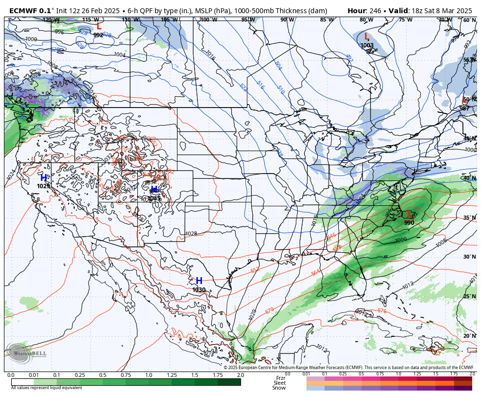
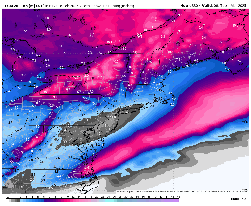
The 6z GFS at 300 hours has a very amped storm that buries the far N/W crowd but screws everyone else with driving 33 degree rain.
Way too far out to have any emotion about it but I’m glad to see the signal.
-
1
-
1
-
-
25 minutes ago, psuhoffman said:
Nope it’s time to take sides. It’s too important. And of you’re not willing to be part of the solution you’re part of the problem. Ban me because I won’t stop. I can’t be silent anymore.
I really think you’ll make a much bigger difference elsewhere.
You are very intelligent, thoughtful, and you know what you’re talking about, so I think the best way to take sides and stand up for what you believe in is in the real world. Not on a weather board.
-
2
-
-
2 hours ago, Maestrobjwa said:
I kinda understand it too. It's become quite intertwined with what's going on in many people's lives right now. However, be that as it may...Given how politics will ultimately cannibalize any other topic or conversation, it's nearly impossible to have that AND stick to the main topic this forum was created for in the first place: weather. So no matter what's going on (and again, i definitely get it),...it would be extremely difficult for the two to coexist without dissolving into who knows what (a la the recently nuked Hood). We're all gonna miss psu here, though! Hope he comes back eventually.
Ideally I wish we could talk about political topics without it becoming about parties or politicians or which side is better, and just keep it a thoughtful discussion about the issues, which I think psuhoffman was aiming to do.
But I understand why most of the staff wants to avoid even that, especially knowing what it can lead to.
And yet if these developments are deeply affecting both our best winter weather poster as well as the owner of this board, then it gets hard to avoid completely.
Alas, there is no perfect answer, and I think we can all agree that we really need a solid, area wide snowstorm before the season ends.
-
1
-
-
1 hour ago, psuhoffman said:
I think around March 6-10th might be our best but final window. As the pacific pattern retrogrades there will be a brief window when there is still antecedent cold left and as a trough builds off the west coast it could favor an amplification in the east. After that the ridge in the WPO will cause some SER and in March any is too much. I'm not convinced its a long term pattern change and we go warm and stay warm but we probably don't have time for another recycle. It might turn colder again towards March 20 but by then we would need a once in 30 year type anomaly to get any snow of significance in the area, even up here.
I probably won't be able to post much longer...so if this is it...its been fun. Wish I could have gone out with a win!
You are one of the most valuable contributors here, and most of us greatly appreciate your knowledge and insights.
As far as politics, I know many of us are headed for some very hard times, and it’s important to speak out.
However, there are a lot of much more effective places to make a difference and have a real impact, than on a weather forum where political talk isn’t allowed.
I don’t want you to leave because of this. If you can’t resist politics, I can invite you to discord channel that many of us have joined, where you’re free to speak your mind all you want.
-
1
-
 2
2
-
1
-
-
1 hour ago, notvirga! said:
I’m not ready for winter to be over. This winter has been an awful tease; really thought I’d finally see a 6” plus snow storm in northern Baltimore Co or least get close to climo. Neither had happened
Nor am I.
March can deviate from the seasonal trend and more than once it has brought the biggest storm of the season. But it has to be a big one to be worth it for me.
Give me 8”+, or give me spring.
-
8 hours ago, bncho said:
lol


-
1 hour ago, Fozz said:
Is it really too much to ask for one dynamic 8-12” snowstorm north of I-70?
It’s like the GFS just heard my wish
49 minutes ago, psuhoffman said:Ok now it’s trolling me
-
5 minutes ago, psuhoffman said:
Good grief

-
1
-
-
Is it really too much to ask for one dynamic 8-12” snowstorm north of I-70?
I’ll take a repeat of March 2018, it looked and felt like midwinter.
-
1
-
-
12 minutes ago, psuhoffman said:
This years snow hole looks about like the Nina snow anomaly map. Just worse and it extends northeast more because we never got the 1-2 typical Nina miller b storms that save NYC-Boston. But not sure this should be all that shocking. Nina’s often have a snow hole between where the southern and southern streak storms set up and it’s often over Maryland northwest of the bay.
Where is that Nina snow anomaly map? I don’t think I’ve seen it
-
15 minutes ago, mitchnick said:
Anybody look at the long range Gfs? Another NC/VA Blizzard. Lol
Oh look, another winter storm for Houston and Pensacola with heavy snow for the same areas getting it Wednesday
-
40 minutes ago, high risk said:
We should all acknowledge as a group that, even if the NAMs are spectacularly wrong on this event, we’re going to miss them like deceased grandparents when they’re retired next year.
Really? Tracking weather won’t be the same without them.
So then which meso models will take their place?
-
1
-
-
3 minutes ago, yoda said:
12z 3km NAM 10:1

Kuchera

Nice jump north. Now let’s do another 50 miles
-
1
-
-
21 hours ago, DDweatherman said:
I love ya Fozz but no way I’m agreeing with this. March 2001 was a BECS for a couple days and then 48 hours out a rug pull, then Boxing Day and Snowquester had WSWarnings in effect when they busted.
losing this 100 hours out and it being dead by 60+ hours out is way different. Yeah it sucked Saturdays 12z gfs came around then they tanked, but it’s a different class.
My point was not that this is the same level as March 2001. Obviously that was a lot more traumatic for those who remember it.
My point is that people will remember this month for this failed storm that could have been, that we thought for several days was real.
-
49 minutes ago, AlexD1990 said:
Nice to see at least there might still be some tracking for a week or two. I'm demented in that I want to at least have a shot through St Patrick's Day ( you can thank 2014 and 2015 for spoiling me and thinking that snow is possible this for South at that date lol)
Yeah if we’re in the game for more storms in March then bring it on. We’ll have plenty more time afterwards for warmth and flowers.
-
1
-
-
54 minutes ago, psuhoffman said:
I can’t believe this is gonna produce nothing for us.

This is one of our worst wasted opportunities in a long long time. This must be how Matt Ryan felt.
This is exactly why I bring this up as a rugpull that will be remembered. Not because it was a bust at the 11th hour, but because this was such an amazing opportunity with that upper level setup that got completely wasted.
-
1
-


March Medium/ Long Range
in Mid Atlantic
Posted
Like I said, give me a MECS or give me spring. I don’t want anything in between.