

Rankin5150
-
Posts
1,026 -
Joined
-
Last visited
Content Type
Profiles
Blogs
Forums
American Weather
Media Demo
Store
Gallery
Posts posted by Rankin5150
-
-
Just now, griteater said:
It's overnight into early morning for Western Carolinas
Grit,
Thank you so very much for all your analysis and PBP. You are a Redtag in my book...all day-EVERY DAY! How much did you end up with in your backyard? Hoping this ULL holds a good surprise for us (or at least the ones who got the shaft on round one). Thanks in advance!
-
3 minutes ago, griteater said:
A visual of the upper low dropping down thru Nebraska and Kansas - https://www.tropicaltidbits.com/sat/satlooper.php?region=atlpac-wide&product=wv-mid
What do you think from what you are seeing, with the formation of the ULL? Does this thing have some horsepower? Or do you think we will just get on and off snow showers? It will be interesting to see where this sets up shop at...
-
ULL's are so tough to forecast. I remember when NWS was calling for 1-2" and when it got going, they came back with the famous "there is a fly in the ointment" in their Forecast Disscusion and we ended up with thundersnow and 10-12" inches on the ground, when it was all said and done. This was from the early 2000's. Do you remember that storm @Queencitywx? I believe we were on the Wright Weather at the time.
-
I cannot get over how heavy it is. We have a pink and blue echo over us, but it is ALL snow and SO HEAVY. It is piling up fast. Almost an inch. From timing it, I would say 1" per hr rates ATTM
-
 3
3
-
-
3 minutes ago, DopplerWx said:
I have never seen flakes this big in my life, unreal!!
SAME HERE! I have the huge returns over me. ALL snow and ground covered.
-
Rippin em here is South Belmont. Looks to be all snow now. Ground starting to cover up!
-
4
-
-
2 hours ago, burgertime said:
Here is the HRR snow map...
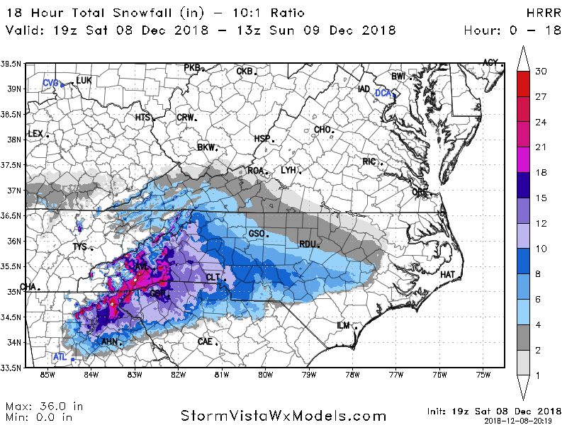
In my dreams man! I wish! I fear the mixing. I think these heavy bands rolling in will cool it off enough for at least a couple of hours of wet snow before back and forth mixing. Thanks for Posting on here the past couple of days!
-
12 minutes ago, griteater said:
FV3 Loop

I wonder roughly how many hours do you think this model recognizes that we have primarily snowfall?
-
12 minutes ago, FallsLake said:
That looks reasonable. I was here for that 2002 storm and it was horrible. We lost a car from a pine tree breaking in half, all of our fence line, and my wife watched as a tree was pulled over from its root ball because of the ice weight. **I like (a little) ice on the trees, but to an extent.
Sorry this happened to you all. I am glad everyone was ok. Our Daughter (now 16 yrs old) was born 12 weeks early and had spent 8 weeks in the Neonatal intensive Care Unit. They released her from the Hospital the evening before go time of the storm. We were without power for 7 days. THANK GOD for Propane Gas Logs to heat our house. I begged for them to keep her there for a few more days and no dice.
-
1
-
-
19 minutes ago, DopplerWx said:
fv3 holds serve, pretty close to 06z

I sure hope this one has the best verification score! WOW. The unrealistic weenie in me loves this one, albeit, it seems to have been the most consistent model the entire process (so far)!
-
3 minutes ago, BFF said:
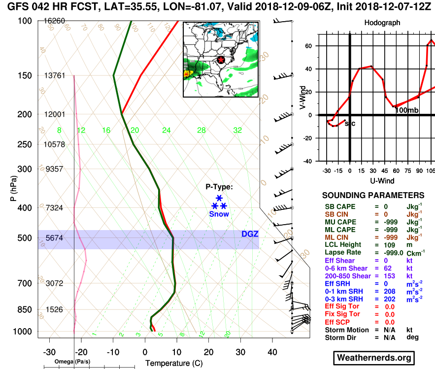
Not a bad sounding right there for CLT at H42. Fully saturated in the DGZ.
Thanks! I have my fingers crossed for the Belmont and Charlotte area(s). Good luck!
-
Just now, burgertime said:
For folks along I-85 GSP to CLT as usual it's gonna be a battle between sleet and snow but if we can get just enough cold air those totals could easily be higher.
I think it will still be some significant totals. I would not be surprised to wring out 8-12" total, based on a blend of all the models right now. My excitement meter is rising fo sho!
-
1
-
-
Just now, Cheeznado said:
Pinch me, I will be headed to AVL tomorrow very early- if they get over 18" (and that seems to be a growing consensus) it will be the biggest snow storm ever there- also I have never personally seen that much snow in one storm.
You will LOVE IT! I experienced 17" from the February, 2004 Storm and I talk about it to this day. It was so unreal to see it that deep. Brought the rabid weenie out in me. We even had thundersnow during the storm. AWESOME!
-
5 minutes ago, burgertime said:
To John Wow's point if you look at hi-res precip type you can see now it's more of a rain/snow battle then flips to sleet for most. I still think this trends colder and you get snow creeping further south. Plus with so much moisture and again thickness right on the edge it should flip it to snow for the most part.
I like where I am at in Belmont, NC
-
6 minutes ago, burgertime said:
Go home NAM you're drunk. This run is bonkers...just bonkers. Backs up FV3 too...just insane. Guess my gut was right

I cannot wait to see the clown map for the NAM, just to compare to the FV-3
-
Just now, burgertime said:
This is at hour 48 with more on the way. GSP in the heat of this has low enough 850's and thickness is good enough to keep it all snow until someone digs through the sounding data.
I see you got my message! This is awesome! Hope it keeps trending!
-
With this being so close to the start of the Winter Storm tomorrow, I feel we need to remember to not lose sight of looking at Radar Trends. They can tell a lot. For example, look at the expansiveness of the moisture. WOW! Someone is MOST DEFINITELY GOING TO GET CLOCKED!
http://www.intellicast.com/National/Radar/Current.aspx?animate=true
i KNOW this is Intellicast Radar, but I am posting this for the ease of viewing, to help any newbies, etc.
-
4
-
-
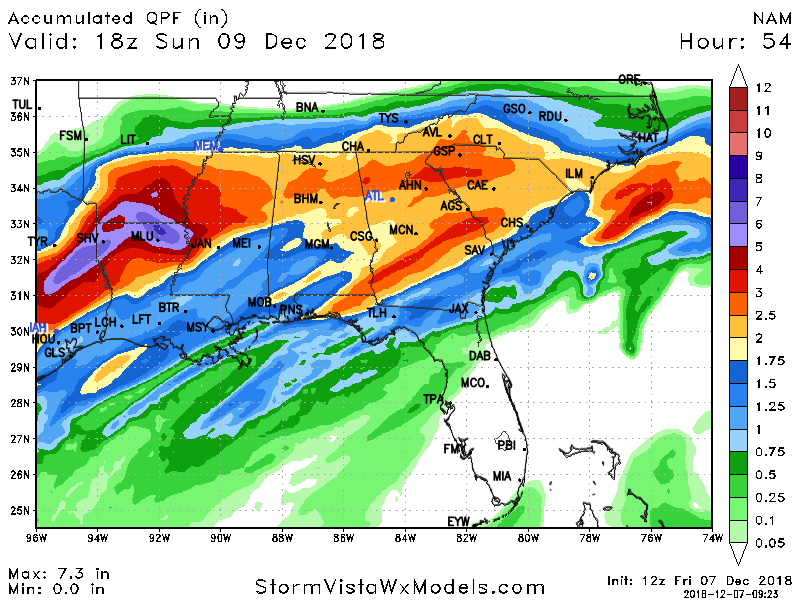
1 hour ago, burgertime said:
I think FV3 seeing ALL precip as snow. Has close to 3 inches of QPF for most of that 30 inch area...850's look pretty good. So cut the actual snow ratio down a bit and you're still at like 12-20 inches if that were to verify.
What if it is correct? I see all the models trending south, hence, this has to mean the cold air is stronger/dryer? I would think this has to bode well for us snow hounds?
-
7 minutes ago, griteater said:
Yeah, they can be modeled too warm with CAD, but that's at the surface. The warmth is going to pour in aloft out of the SE and East. Tough forecast. The FV3 solution of holding the cold via strong ascent (strong rising motion is a cooling mechanism thru the column) isn't out of the question, but I don't think it's right. Time will tell
BINGO!!! This is what I was looking for. I could not put the words together on what I was thinking. Thanks.
-
Just now, griteater said:
Prior to the 00z runs I said 1-3 of snow/sleet/slop for Charlotte, then up to 1 inch with the backside snow showers on Monday. I would now change that to 3-6 of snow changing to sleet, then up to an inch of snow on Monday. This precip should come in fast and furious Saturday evening and overnight.
Awesome! Is there still the chance that we get hit with a major front end thump and it keeps the layers colder than progged, which would limit mixing? I wonder what the odds would be? I would say 7 times out of 10 (this may be conservative) the CAD in winter storms has been forecasted too warm by the models. Is that a fair statement?
-
I am rooting for the FV3-GFS ALL. THE. WAY! That is too good to be true, albeit, it has been the MOST consistent model the ENTIRE time. Wow posted a comparison earlier which was eye opening. What to think? I cannot get over it. I know NWS and all the other Meteorologists are like "which way to go?"
-
1
-
-
11 minutes ago, griteater said:
That's a long event

Grit,
Correct me if I am wrong, but we are on the cusp of a DOOZY of a storm for our areas, if this verifies. I mean...this is a long duration with more snow than mixing. Correct? I also notice the other Models starting to move in the direction of the FV3-GFS. No? Thank you for putting this together. Looks awesome!
-
10 minutes ago, kvegas-wx said:
Burger showing up for a PBP tonight?
I corresponded with Burger this morning and he told me to pass along to everyone that he would be tied up, but he wished he could. He will check back in ASAP.
-
Just now, SnowDawg said:
I'm viewing on WxBell so I'm not sure about the rules on me sharing that but I will say for your location your mean is probably around a foot maybe a little more on that run. Compare that to the last run where it was probably 9 or so and then even better if you consider how far north the 12z run went when that areas mean dropped all the way to around 5-6. So a pretty substatial trend south over the last 2 GEFS runs.
Thank you so much! I really appreciate that. This is what I was THINKING on the mean. This sounds awesome and hoping it is a trend that will stick. For it to show in this timeframe is great. I know from tracking storms from WWB and since the inception of American Weather, I have seen CAD perform colder than progged, I am feeling this in my gut for this system. Thanks again and good luck!
December 8-10 Winter Storm Obs
in Southeastern States
Posted
Hey there Jerry! It has been forever! I hope all is well with you and yours!
Best,
Jason