

sarcean
-
Posts
206 -
Joined
-
Last visited
Content Type
Profiles
Blogs
Forums
American Weather
Media Demo
Store
Gallery
Posts posted by sarcean
-
-
4 minutes ago, wxduncan said:
The totals towards CLT and south might be knocked down a bit. But I-40 west(Hickory,Morganton,Lenoir,Mtns) look just fine even Brad P. said totals could be underdone for those areas.
I'm in Greensboro but plan to go to Boone or Banner Elk Sat night if the Triad somehow busts. I'm confident I'll find a monster of a storm past a certain elevation.
-
2 minutes ago, Iceagewhereartthou said:
Are we sure that's not their "high end" map? They used to put out 3 different ones; one for low end totals, one for high end, and one for the middle road (and most likely).
nope that is there expected
this is there "high end map"

-
I'm sure it could of been posted but can't believe GSP has put out these amounts already

-
2 minutes ago, Queencitywx said:
3K NAM has the snow line advancing southward at 60.
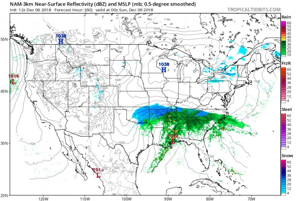
Real interested to how NAM-3K picks up precip types as it comes more into play
-
Just now, AsheCounty48 said:
ICON has started, let's see if we can get a better solution.
hasn't ICON been on its own island these last few days?
-
7 minutes ago, mclean02 said:
Yeah I hope they are wrong but normally when they are meh or have low confidence about a storm they are right quite a bit. I hope that changes today !
It's basically RAH vs every model at this point. They will have to cave if these models keep it up (atleast for the Triad) today or tomorrow or they risk it being too late too sound an alarm.
I understand they don't want their torecacts to busts but I don't remember a winter storm ever getting this general model concensus for this many days straight
-
 2
2
-
 1
1
-
-
RAH is still almost refusing to acknowledge the possibility of significant snow
Wintry precipitation is still likely this weekend and confidence in said occurrence is high, however the exact timing, amounts and p-types are still uncertain due to continued model differences and
thus low confidence. Best chances for wintry precipitation are still
along and north of the US-1 corridor.

Overview: A pair of upper level lows/troughs will develop  on Saturday, one off the Southern Rockies/Desert Southwest and the other over the Northern High Plains/SW Canada. The former will shift eastward then east-northeastward through the ARKLATEX and into the TN Valley while the latter will dive south-southeastward, deepening
over the Plains/Midwest. The southern stream low will become absorbed into the stronger northern stream low over the MS/TN Valley Monday/Monday night as it continues its southward dive toward the
Gulf. Expect strong moisture advection into the Gulf Coast states and Southeast US ahead of the system Saturday and Sunday. Cold, high pressure will dominate at the surface over the Great Lakes region, ridging into western/central NC through the period in a CAD setup.
Meanwhile, a surface low will develop along the Gulf Coast on Saturday in response to the upper level system. The surface low is
expected to move along the Gulf Coast, through the panhandle of FL and northeast along the Carolina coast, while the wedge remains in place over northwestern portions of the area. As a result, there will be a very strong pressure gradient from west to east across NC on Sunday/Sunday night. Even the slightest shift in track, timing, temperature, etc. will result in significant impacts to the
forecast.

Timing: The latest medium-range models suggest precipitation will likely move into central NC very slowly from the south-southwest late Saturday or Saturday night. The ECMWF continues to be a tad
slower than the GFS, though the timing has come into significantly better agreement from 24 hours ago.

P-type: As mentioned above, a lot of uncertainty still remains with respect to wintry precipitation, as any small change/difference in timing, temperature, thermal profile, etc. will impact the p-type. As past events would suggest, a purely snow event is not likely as there is usually a mix of wintry p-types. Expect precipitation to
start as rain across the far south and southwest, though chances are looking decent for a mix of rain/snow across the northwest half of
central NC when precipitation moves in overnight. A mix of p-types, especially over the northwest half of central NC, is likely overnight as temperatures fall, while the southeast could remain
rain for the duration. Expect several p-type changes throughout the
event, especially along and north of US-1, with snow, sleet and freezing rain all possibilities. Regardless of p-type, liquid equivalents could range from one to two inches. Will hold of on getting too cute with any snow amounts at this time given the degree of uncertainty and how the varying p-types would impact accumulations.

Temperatures: Highs on Sunday expected to top out in the low to mid 40s while Sunday will be much colder in the NW, with highs topping out around freezing while the SE should reach into mid 40s again.
Lows both Saturday and Sunday nights will be similar, upper 20s to
mid 30s Saturday night and low 30s to around 40 degrees Sundayb night. Monday highs in the upper 30s to mid 40s expected at this time. -KC

Monday night through Wednesday: Medium range model guidance in
general agreement depicting a deep upper level low traversing the SE U.S., initiating yet another deepening sfc wave just offshore of SC/southern NC. The string dynamics associated with the upper level low and the potential for the sfc wave to sling moisture back into central NC. The models have trended a little farther south with the system and attendant precipitation. Thus, expect a chance of rain or rain/snow mixed primarily focused across the southern counties Monday night. If the system drifts just a little farther north, could see a threat for snow across the northern counties with some light accumulation possible. Min temperatures generally in the 20s to the lower 30s.

The upper level system and associated coastal low will sweep quickly eastward and offshore Tuesday with improving weather conditions into mid week. If there is any residual snow/ice pack across the Piedmont, could see temperatures Tuesday night drop into the teens. Away from the snow/ice pack, expect overnight lows in the 20s. Afternoon highs will remain well below normal with high temperatures in the 40s expected, closer to 50 across the far south southeast by
mid week. -WSS
-
11 minutes ago, Bamabuilder86 said:
How do y’all think I-40 will be on Monday in terms of travel? Obviously this could be a huge storm but how well is it usually handled? I need to be traveling west on I-40 Monday morning from black mountain
Good chance i40 gets shut down at some point atleast from Asheville to Statesville
-
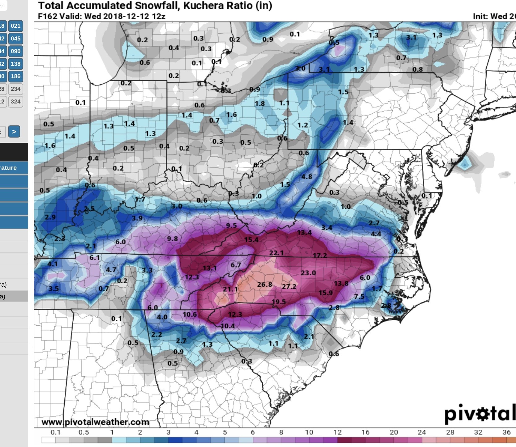
16 minutes ago, Brick Tamland said:
This might be more realistic.
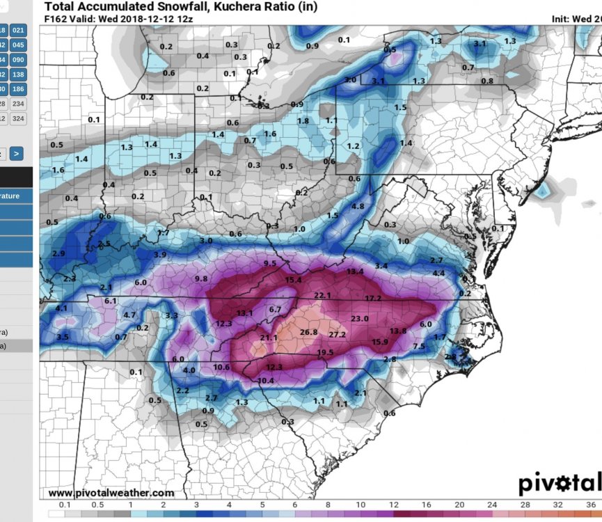
History has told me there is nothing realistic about Greensboro getting 23" but would love to see it
-
3
-
 2
2
-
-
Greensboro just updated before they were calling for rain/sleet with only slight snow...

Now
Saturday NightSnow likely, mainly after 1am. Cloudy, with a low around 30. Chance of precipitation is 60%.SundaySnow before 1pm, then rain. High near 34. Chance of precipitation is 80%.Sunday NightA chance of snow before 11pm, then snow and sleet likely between 11pm and 4am, then snow likely after 4am. Cloudy, with a low around 31. Chance of precipitation is 60%.MondayRain and snow likely. Cloudy, with a high near 39. Chance of precipitation is 60%.Monday NightA chance of snow. Mostly cloudy, with a low around 27. Chance of precipitation is 40%. -
Every model is saying RAH is being too conservative, this storm is REALLY going to catch some people by surprise. Guess they don't care about calling it safe since the event is on a weekend?
-
when does the 3K NAM window come into play? isn't it suppose to be quite accurate sniffing our precip types
-
Just now, Orangeburgwx said:
Not only that it keeps bobbing between north one run and south the next... Someone (I'm thinking the I85 corridor around Atlanta) is going to be drilled by a nasty ice storm
I know there is a question of how far south and east the snow will get (and how cold it will be) but here in the triad (Greensboro) up to the high country in Boone have been in a great spot nearly every model run by every model .
NWS is still calling it conservative with lots of mixed precip in the forecast
-
I am just waiting for the rug to be pulled out from under this storm but model after model keeps showing the same (more or less). I can't recall this level of model consistently from this far out possibly ever.
-
2
-
-
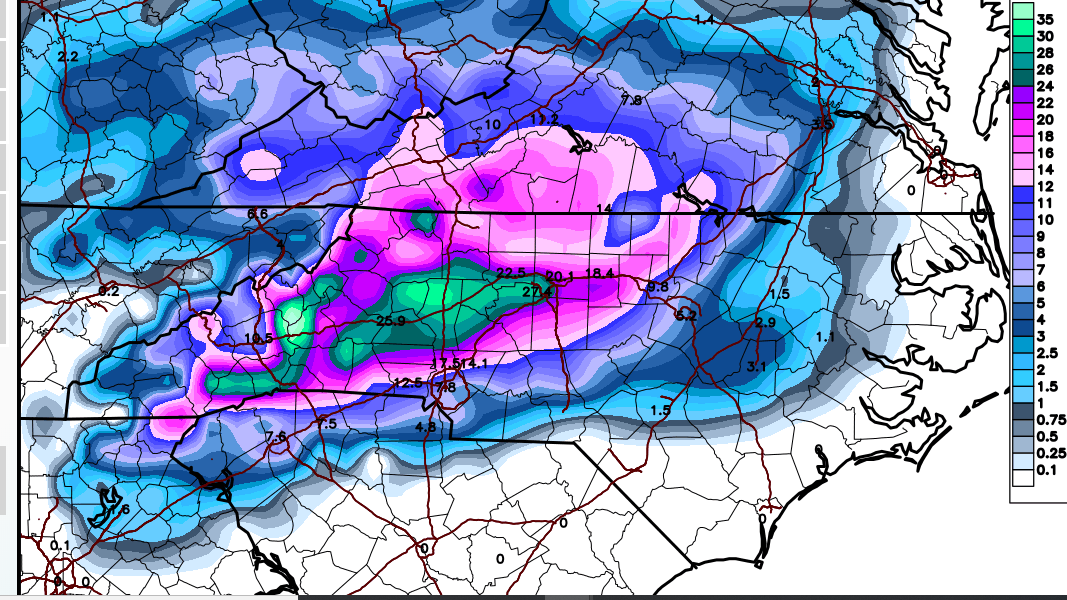
30 minutes ago, burgertime said:
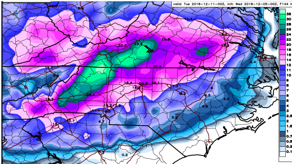
Storm keeps going until Tuesday. Somewhere around GSO gets 18-21 inches if it were all snow.
I would take that in a heart beat. Would be an incredible storm.
I've lived in Greensboro since 2005 and never remember over 10 inches
-
1
-
-
21 minutes ago, Poimen said:
The 0Z FV 3 and 6Z GFS were great runs for the NC Piedmont.
I would like to cash out and take this to the bank
Hell I would be very happy with half that
-
1
-
-
17 minutes ago, Brick Tamland said:
I guess i can live with a foot+in Greensboro but really hoping Boone / Banner Elk jackpots wifh 2 feet
But really the size of that green area is absurd
-
1
-
-
10 minutes ago, Ericjcrash said:
No one can prepare for 2' except local municipalities off the lakes lol.
A few years ago I went up to Snowshoe, West Virginia for the 3 foot blizzard that also hit DC (was something to behold), plan on being in Boone/Banner Elk this weekend. Had never been in snow like that before, One of those things I will remember forever.

-
1
-
-
Hard to think we are not on the brink of a potentially historic storm for atleast some of North Carolina
-
I feel relatively confident in Greensboro that there will be enough cold and liquid to make something significant happen
-
2
-
-
1 minute ago, Queencitywx said:
I really doubt this storm ends up as 100% snow for anyone except the mountains, including the foothills. The ratio of sleet to snow obviously grows as you push further east but the question is how much sleet. I do feel pretty confident right now that it's either going to be sleet or snow at this juncture IMBY.
There is so much QPF that there doesn't need to be all snow to be a great storm. With nearly 2" of liquid...even if it is a 6:1 or 8:1 ratio for a decent portion of the event, it will still be significant.
-
3 minutes ago, HKY_WX said:
I'll be in Banner Elk this wknd lol... Will be interesting dor sure... As grit noted, this stj low has the hallmarks of a memorable el Nino snow/ice maker ala def 02 and feb04.
I plan on going to Banner Elk to Sugar Mountain...if I can make it! If these snow totals are even remotely close travel will be damn near impossible past Boone.
-
Where can I see all the euro ensembles?
-
Hoping it stays cold enough here in Greensboro / the Triad about 30 miles from the VA border for a mostly snow event


December 8-10, 2018 Winter Storm
in Southeastern States
Posted
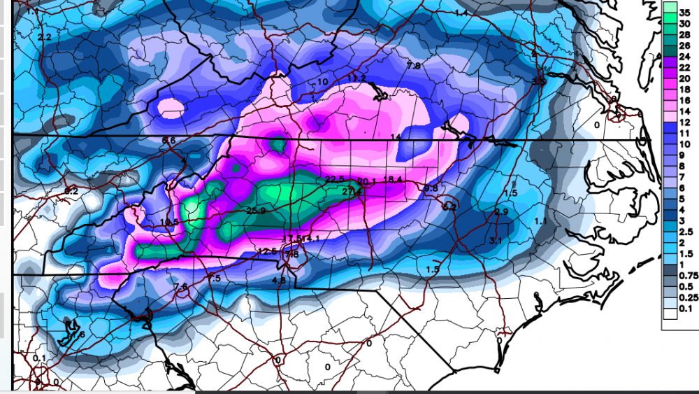
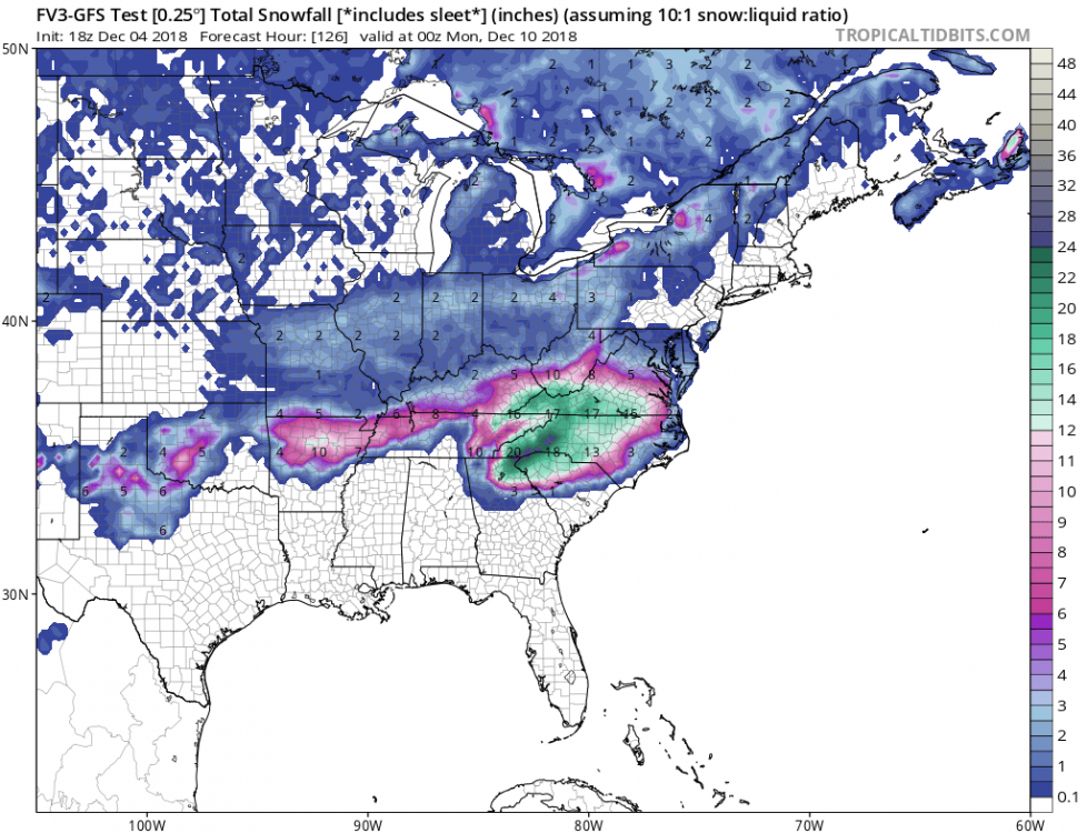
beautiful totals for here in the Triad...i would love for that to verify